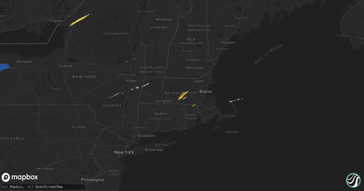
Hail Map on March 29, 2020
Get this storm
March 29 map
$229
one time, instant access
Download today. No call, no setup
Keep the $229
Bought the map and want the full workflow? Apply the entire $229 to a subscription within 7 days. None of it is wasted.
Every map, not just this one
This buys you this map. Subscription and you get every map we run, in the markets you choose from a few cities to whole states to nationwide. Plus real-time alerts the moment a storm fires.
Contact data
Name, contact info, occupancy, even credit band for addresses in the footprint. You go from where it hit to who to call.
Become the source they trust
Unlimited branding weather history reports on demand. You already have the documented answer ready for the property owner, and you are the one who showed up with it.
Property data and RoofTrace estimates
Pull up any address you have got, its value and the exact code rules for that jurisdiction, straight from One Click Code. Then RoofTrace estimates the squares, pitch, and roof value, priced the way you price.
States Impacted by Hail Map on March 29, 2020
Storm reports
Georgia
| Date | Description |
|---|---|
| 03/29/20202:12 AM CDT | At 712 AM EDT, a severe thunderstorm was located over Ellijay, moving east at 55 mph. HAZARD...60 mph wind gusts and quarter size hail. SOURCE...Radar indicated. IMPACT...Hail damage to vehicles is expected. Expect wind damage to roofs, siding, and trees. Locations impacted include... Ellijay, Blue Ridge, East Ellijay, Morganton, Hemp, Talona, Tails Creek, Margret, Higdon, Hurst, Loving, Dial, Springer Mountain Shelter, Cartecay, Pisgah, Mineral Bluff, Cherry Log, Mountaintown, Stover Creek Shelter and Colwell. |
Virginia
| Date | Description |
|---|---|
| 03/29/20204:10 PM CDT | Tree down on mountain valley road a couple of miles north of axton. Tree briefly blocking the road. |
| 03/29/20201:38 AM CDT | At 638 AM EDT, severe thunderstorms were located along a line extending from near Rogersville to 10 miles southeast of Russellville to near Newport, moving east at 75 mph. HAZARD...60 mph wind gusts. SOURCE...Radar indicated. IMPACT...Expect damage to roofs, siding, and trees. Locations impacted include... Johnson City, Kingsport, Greeneville, Newport, Gate City, Jonesborough, Tusculum, Surgoinsville, Weber City and Parrottsville.This includes the following highways... Interstate 26 in Tennessee between mile markers 1 and 17. Interstate 40 in Tennessee between mile markers 434 and 436. Interstate 81 in Tennessee between mile markers 23 and 65. |
| 03/29/20201:11 AM CDT | At 610 AM EDT, severe thunderstorms were located along a line extending from 7 miles east of Tazewell to near Maryville, moving northeast at 60 mph. HAZARD...60 mph wind gusts and penny size hail. SOURCE...Radar indicated. IMPACT...Expect damage to roofs, siding, and trees. Locations impacted include... Morristown, Sevierville, Jefferson City, Newport, Rogersville, Gatlinburg, Dandridge, Sneedville, Rutledge and Pigeon Forge.This includes the following highways... Interstate 40 in Tennessee between mile markers 401 and 435. Interstate 81 in Tennessee between mile markers 1 and 25. |
New York
| Date | Description |
|---|---|
| 03/29/20204:30 PM CDT | A local report indicates 1.00 inch wind near 2 S GOUVERNEUR |
| 03/29/20204:22 PM CDT | Time based on radar |
| 03/29/20201:24 PM CDT | Multiple large trees down. |
| 03/29/20201:12 PM CDT | Large tree down |
| 03/29/20201:08 PM CDT | Tree down on house on ransom rd. |
| 03/29/20201:07 PM CDT | Tree and power lines down on stony road between pleasant view and genesee in lancaster. |
| 03/29/20201:05 PM CDT | Siding and signs down at walden and transit. Time is based on radar. |
| 03/29/20201:04 PM CDT | A local report indicates 68 MPH wind near BUFFALO AIRPORT |
| 03/29/202012:22 AM CDT | At 521 PM EDT, a severe thunderstorm was located near West Fowler, moving northeast at 55 mph. HAZARD...60 mph wind gusts and quarter size hail. SOURCE...Radar indicated. IMPACT...Minor hail damage to vehicles is possible. Expect wind damage to trees and powerlines. Locations impacted include... Potsdam, Gouverneur, Canton, De Kalb, Fowler, Colton, Degrasse, Hermon, Richville, Pierrepont, Russell, Fine, Rossie, Pitcairn, Stark, Edwards, West Parishville, Talcville, South Edwards and North Gouverneur. |
| 03/29/202012:11 AM CDT | At 511 PM EDT, a severe thunderstorm was located 8 miles south of Redwood, or 8 miles north of Fort Drum, moving northeast at 50 mph. HAZARD...Quarter size hail. SOURCE...Radar indicated. IMPACT...Minor damage to vehicles is possible. Locations impacted include... Redwood, Philadelphia, Theresa, Antwerp, Plessis, Oxbow and Muskellunge Lake. This includes Interstate 81 near exit 49. |
| 03/28/202010:10 PM CDT | At 310 PM EDT, a severe thunderstorm was located over Warsaw, or 11 miles northwest of Letchworth State Park, moving northeast at 65 mph. HAZARD...60 mph wind gusts and quarter size hail. SOURCE...Radar indicated. IMPACT...Minor damage to vehicles is possible. Expect wind damage to roofs, siding, and trees. Locations impacted include... Geneseo, Letchworth State Park, Perry, Warsaw, Avon, Mount Morris, Attica, Pavilion, Conesus and Bristol. This includes Interstate 390 between exits 6 and 10. |
| 03/28/20209:56 PM CDT | At 255 PM EDT, a severe thunderstorm was located over East Branch Dam, moving northeast at 50 mph. HAZARD...60 mph wind gusts and quarter size hail. SOURCE...Radar indicated. IMPACT...Hail damage to vehicles is expected. Expect wind damage to trees, roofs, and siding. This severe thunderstorm will be near... Elk River around 300 PM EDT. Betula and Sizerville around 310 PM EDT. Keating Summit and Roulette around 320 PM EDT. Coudersport around 330 PM EDT.Other locations impacted by this severe thunderstorm include Austin,Oswayo, Sweden Valley, Ski Denton Ski Area and Ulysses. |
| 03/28/20209:41 PM CDT | At 241 PM EDT, severe thunderstorms were located along a line extending from near Albion to near Batavia, moving east at 50 mph. HAZARD...60 mph wind gusts and nickel size hail. SOURCE...Radar indicated. IMPACT...Expect damage to roofs, siding, and trees. Locations impacted include... Rochester, Greece, Irondequoit, Chili, Brockport, East Rochester, Hilton, Webster, Fairport and Brighton. This includes the following highways... Interstate 390 between exits 11 and 12. Interstate 90 between exits 47 and 45. |
| 03/28/20209:03 PM CDT | At 202 PM EDT, severe thunderstorms were located along a line extending from near Sanborn to West Seneca, moving northeast at 55 mph. HAZARD...60 mph wind gusts and nickel size hail. SOURCE...Radar indicated. IMPACT...Expect damage to roofs, siding, and trees. Locations impacted include... Akron, Alden, Batavia, Gasport, Medina, Albion, Darien Lakes State Park, Newfane, Marilla, Pembroke, Bennington and Akron. This includes Interstate 90 between exits 48A and 48. |
| 03/28/20208:24 PM CDT | At 122 PM EDT, severe thunderstorms were located along a line extending from 26 miles southwest of Niagara Falls to near Lake Erie State Park, moving northeast at 50 mph. HAZARD...60 mph wind gusts and nickel size hail. SOURCE...Radar indicated. IMPACT...Expect damage to roofs, siding, and trees. Locations impacted include... Buffalo, Cheektowaga, Niagara Falls, West Seneca, North Tonawanda, Lackawanna, Kenmore, Dunkirk, Silver Creek, Angola, and Perrysburg. This includes Interstate 90 between exits 60 and 49. |
| 03/28/20208:18 PM CDT | At 117 PM EDT, a severe thunderstorm was located near Erie, moving northeast at 50 mph. HAZARD...60 mph wind gusts and quarter size hail. SOURCE...Radar indicated. IMPACT...Minor damage to vehicles is possible. Expect damage to trees and power lines. Locations impacted include... Erie, North East, Northwest Harborcreek, Harborcreek, Lawrence Park, Wesleyville, McKean, Northwest Harborcr and Avonia. |
Indiana
| Date | Description |
|---|---|
| 03/29/202011:20 AM CDT | Report from mping: 1-inch tree limbs broken; shingles blown off. |
| 03/29/20207:04 AM CDT | At 1203 AM EDT, a severe thunderstorm was located over Patriot, moving east at 40 mph. HAZARD...60 mph wind gusts. SOURCE...Radar indicated. IMPACT...Expect damage to trees and power lines. Locations impacted include... Covington, Florence, Independence, Erlanger, Fort Thomas, Newport, Edgewood, Alexandria, Elsmere, Fort Mitchell, Villa Hills, Highland Heights, Taylor Mill, Fort Wright, Southgate, Crescent Springs, Walton, Crestview Hills, Park Hills and Lakeside Park.This includes the following Interstates... I-71 in Kentucky between mile markers 71 and 77. I-75 in Kentucky between mile markers 167 and 190. |
Kentucky
| Date | Description |
|---|---|
| 03/29/20207:54 AM CDT | At 1254 AM EDT, a severe thunderstorm was located 12 miles southeast of Springfield, moving east at 45 mph. HAZARD...60 mph wind gusts. SOURCE...Radar indicated. IMPACT...Expect damage to roofs, siding, and trees. Locations impacted include... Danville, Harrodsburg, Junction City, Burgin, Brumfield, Alum Springs, Caldwell Manor, Parksville, Forkland and Faulconer. |
| 03/28/202011:23 PM CDT | At 422 AM EDT, severe thunderstorms were located along a line extending from near Strunk to 9 miles northeast of Wartburg, moving northeast at 70 mph. HAZARD...70 mph wind gusts and penny size hail. SOURCE...Radar indicated. IMPACT...Expect considerable tree damage. Damage is likely to mobile homes, roofs, and outbuildings. Locations impacted include... La Follette, Oneida, New Tazewell, Tazewell, Jacksboro, Huntsville, Harrogate, Jellico, Caryville and Rocky Top.This includes Interstate 75 in Tennessee between mile markers 125 and161. |
| 03/28/202010:47 PM CDT | At 346 AM EDT, severe thunderstorms were located along a line extending from 8 miles north of Monterey to 7 miles southwest of Crossville, moving northeast at 65 mph. HAZARD...60 mph wind gusts and quarter size hail. SOURCE...Radar indicated. IMPACT...Hail damage to vehicles is expected. Expect wind damage to roofs, siding, and trees. Locations impacted include... Oneida, Wartburg, Oliver Springs, Huntsville, Helenwood, Harriman, Winfield, Sunbright, Oakdale and Rugby. |
Connecticut
| Date | Description |
|---|---|
| 03/29/20203:52 AM CDT | At 852 PM EDT, a severe thunderstorm was located near Glocester, or 11 miles north of Coventry, moving northeast at 40 mph. HAZARD...Quarter size hail. SOURCE...Radar indicated. IMPACT...Minor hail damage to vehicles is possible. Locations impacted include... Pawtucket, Woonsocket, Cumberland, North Providence, Franklin, Johnston, North Attleborough, Attleboro, Walpole, Mansfield, Smithfield, Lincoln, Central Falls, Norton, Killingly, Foxborough, Bellingham, Burrillville, North Smithfield and Norfolk. |
| 03/29/20203:34 AM CDT | At 834 PM EDT, a severe thunderstorm was located over Sturbridge, or 16 miles southwest of Worcester, moving northeast at 55 mph. HAZARD...Quarter size hail. SOURCE...Radar indicated. IMPACT...Minor hail damage to vehicles is possible. Locations impacted include... Worcester, Marlborough, Shrewsbury, Milford, Hudson, Westborough, Grafton, Holden, Webster, Southbridge, Ashland, Auburn, Northbridge, Hopkinton, Northborough, Oxford, Clinton, Holliston, Millbury and Charlton. |
Alabama
| Date | Description |
|---|---|
| 03/28/20209:52 PM CDT | At 251 AM CDT, a severe thunderstorm was located near Arley, moving northeast at 70 mph. HAZARD...60 mph wind gusts and quarter size hail. SOURCE...Radar indicated. IMPACT...Hail damage to vehicles is expected. Expect wind damage to roofs, siding, and trees. Locations impacted include... Southwestern Huntsville, Decatur, Madison, Cullman, Hartselle, Arab, Redstone Arsenal, Hanceville, Priceville and Good Hope. |
| 03/28/20209:42 PM CDT | At 242 AM CDT, a severe thunderstorm was located near Fayetteville, moving northeast at 65 mph. HAZARD...60 mph wind gusts and quarter size hail. SOURCE...Radar indicated. IMPACT...Hail damage to vehicles is expected. Expect wind damage to roofs, siding, and trees. Locations impacted include... Winchester, Fayetteville, Lynchburg, Decherd, Estill Springs, Tims Ford Lake, Lincoln, Howell, Hurdlow and Mimosa. |
| 03/28/20209:33 PM CDT | At 233 AM CDT, a severe thunderstorm was located near Paulette, or 13 miles southwest of Pickensville, moving northeast at 60 mph. HAZARD...Golf ball size hail and 60 mph wind gusts. SOURCE...Radar indicated. IMPACT...People and animals outdoors will be injured. Expect hail damage to roofs, siding, windows, and vehicles. Expect wind damage to roofs, siding, and trees. Locations impacted include... Aliceville, Gordo, Carrollton, Pickensville, McMullen, Garden, Benevola, Johnston Lake, Bevill Lock And Dam, Gainesville Lake Campground, Dillburg, George Downer Airport, Owens, Kirk, Pioneer and Cochrane. |
| 03/28/20209:27 PM CDT | At 227 AM CDT, severe thunderstorms were located along a line extending from near Brilliant to near Eldridge to near Fayette, moving northeast at 75 mph. HAZARD...Ping pong ball size hail and 60 mph wind gusts. SOURCE...Radar indicated. IMPACT...People and animals outdoors will be injured. Expect hail damage to roofs, siding, windows, and vehicles. Expect wind damage to roofs, siding, and trees. Locations impacted include... Jasper, Haleyville, Carbon Hill, Lynn, Arley, Double Springs, Addison, Kansas, Nauvoo, Eldridge, Curry, Houston Recreational Area, Camp McDowell, Smith Dam, Nesmith, Ashbank, Brushy Lake, Poplar Springs, Ashridge and Falls City. |
| 03/28/20209:08 PM CDT | At 208 AM CDT, severe thunderstorms were located along a line extending from near Lamar County Airport to near Vernon to near Millport, moving northeast at 75 mph. These are very dangerous storms. HAZARD...Baseball size hail and 70 mph wind gusts. SOURCE...Radar indicated. IMPACT...People and animals outdoors will be severely injured. Expect shattered windows, extensive damage to roofs, siding, and vehicles. Locations impacted include... Winfield, Fayette, Guin, Brilliant, Glen Allen, Belk, Gu- Win, Lake Buttahatchee, Bluff, Twin, Tucker, Bazemore, Wayside, Richard Arthur Field, Bevill State College Fayette, Hubbertville, Fowlers Crossroads, Texas and Piney Grove. |
| 03/28/20208:53 PM CDT | At 152 AM CDT, severe thunderstorms were located along a line extending from 6 miles southeast of Aberdeen to near Caledonia to near Columbus, moving northeast at 60 mph. HAZARD...Golf ball size hail and 60 mph wind gusts. SOURCE...Radar indicated. IMPACT...People and animals outdoors will be injured. Expect hail damage to roofs, siding, windows, and vehicles. Expect wind damage to roofs, siding, and trees. Locations impacted include... Vernon, Sulligent, Millport, Kennedy, Detroit, Beaverton, Blooming Grove, Lamar County Airport, Crews, Bedford, Cody, Henson Springs, Lamar County Public Lake, Star, Pine Springs, Hightogy and Melborne. |
| 03/28/20208:50 PM CDT | At 150 AM CDT, a severe thunderstorm was located over Columbus AFB, moving northeast at 55 mph. HAZARD...60 mph wind gusts and quarter size hail. SOURCE...Radar indicated. IMPACT...Hail damage to vehicles is expected. Expect wind damage to roofs, siding, and trees. Locations impacted include... New Hamilton. |
| 03/28/20208:37 PM CDT | At 137 AM CDT, a severe thunderstorm was located over Leighton, or 7 miles east of Muscle Shoals, moving northeast at 65 mph. HAZARD...60 mph wind gusts and quarter size hail. SOURCE...Radar indicated. IMPACT...Hail damage to vehicles is expected. Expect wind damage to roofs, siding, and trees. Locations impacted include... Muscle Shoals, Tuscumbia, Rogersville, Ardmore, Killen, Town Creek, Lexington, Leighton, Elkmont and Anderson. |
North Carolina
| Date | Description |
|---|---|
| 03/29/20202:06 AM CDT | At 705 AM EDT, severe thunderstorms were located along a line extending from near Weber City to Oak Grove to near Erwin, moving east at 75 mph. HAZARD...60 mph wind gusts. SOURCE...Radar indicated. IMPACT...Expect damage to roofs, siding, and trees. Locations impacted include... Johnson City, Kingsport, Bristol Tn, Bristol Va, Elizabethton, Abingdon, Erwin, Mountain City, Jonesborough and Central.This includes the following highways... Interstate 26 in Tennessee between mile markers 15 and 37. Interstate 81 in Tennessee between mile markers 62 and 75. Interstate 81 in Virginia between mile markers 1 and 34. |
Rhode Island
| Date | Description |
|---|---|
| 03/28/20208:20 PM CDT | Broadcast media |
Ohio
| Date | Description |
|---|---|
| 03/29/20207:19 AM CDT | At 1218 AM EDT, a severe thunderstorm was located near Waynesfield, moving northeast at 65 mph. HAZARD...60 mph wind gusts. SOURCE...Radar indicated. IMPACT...Expect damage to trees and power lines. Locations impacted include... Kenton, Ada, Forest, Russells Point, Lakeview, Dunkirk, Alger, Waynesfield, Belle Center, Chippewa Park, Blanchard, Roundhead, Mcguffey, Patterson, Dola, Grant, Silver Creek, Jumbo, Huntersville and Walton. |
Massachusetts
| Date | Description |
|---|---|
| 03/29/20205:13 AM CDT | At 1012 PM EDT, a severe thunderstorm was located over Marion, moving northeast at 55 mph. HAZARD...Quarter size hail. SOURCE...Radar indicated. IMPACT...Minor hail damage to vehicles is possible. Locations impacted include... New Bedford, Plymouth, Marion, Provincetown, Middleborough, Wareham, Sandwich, Bourne, Fairhaven, Carver, Lakeville, Acushnet, Freetown, Mattapoisett, Rochester and Truro. |
| 03/29/20204:52 AM CDT | At 952 PM EDT, a severe thunderstorm was located over Westport, or 7 miles south of Fall River, moving northeast at 55 mph. HAZARD...Quarter size hail. SOURCE...Radar indicated. IMPACT...Minor hail damage to vehicles is possible. Locations impacted include... New Bedford, Fall River, Plymouth, Dartmouth, Marion, Middleborough, Wareham, Portsmouth, Fairhaven, Tiverton, Westport, Carver, Lakeville, Acushnet, Freetown, Mattapoisett, Rochester and Little Compton. |
| 03/29/20203:55 AM CDT | At 854 PM EDT, a severe thunderstorm was located over Shrewsbury, moving northeast at 55 mph. HAZARD...Quarter size hail. SOURCE...Radar indicated. IMPACT...Minor hail damage to vehicles is possible. Locations impacted include... Worcester, Newton, Framingham, Marlborough, Shrewsbury, Chelmsford, Natick, Needham, Milford, Wellesley, Dedham, Westford, Acton, Hudson, Westborough, Grafton, Concord, Sudbury, Holden and Webster. |
| 03/29/20203:47 AM CDT | At 847 PM EDT, a severe thunderstorm was located over Hawley, or 13 miles southeast of North Adams, moving east at 60 mph. HAZARD...Quarter size hail. SOURCE...Radar indicated. IMPACT...Minor hail damage to vehicles is possible. Locations impacted include... Greenfield, Orange, Deerfield, Monroe, Athol, Montague, Sunderland, Northfield, Bernardston, Buckland, Conway, Shelburne, Leverett, Erving, Ashfield, Colrain, Gill, Charlemont, Royalston and Goshen. |
| 03/29/20203:41 AM CDT | At 841 PM EDT, a severe thunderstorm was located near Savoy, or 7 miles south of North Adams, moving east at 65 mph. HAZARD...Quarter size hail. SOURCE...Radar indicated. IMPACT...Damage to vehicles is expected. Locations impacted include... North Adams, Adams, Cheshire, Florida, Savoy, Windsor, Whitcomb Summit, Soldiers Memorial Field, Rusek Whipple Square, Cheshire Harbor, Arnoldville, Renfrew, Savoy Center, Town Crest Village, Brier, Little Egypt, East Renfrew, Maple Grove, Eastern Summit and Zylonite. |
| 03/28/20209:05 PM CDT | A local report indicates 1.00 inch wind near NEW BEDFORD |
| 03/28/20207:56 PM CDT | Amateur radio |
| 03/28/20207:53 PM CDT | Trained spotter |
| 03/28/20207:50 PM CDT | Near the spencer line |
| 03/28/20207:47 PM CDT | A local report indicates 1.00 inch wind near SAVOY |
Tennessee
| Date | Description |
|---|---|
| 03/29/20207:52 AM CDT | At 1252 AM CDT, a severe thunderstorm was located near Lexington, or 16 miles northeast of Florence, moving northeast at 65 mph. HAZARD...60 mph wind gusts and nickel size hail. SOURCE...Radar indicated. IMPACT...Expect damage to roofs, siding, and trees. Locations impacted include... Pulaski, Loretto, St. Joseph, Elkton, Minor Hill, Goodspring, Leoma and Iron City.This includes Interstate 65 between mile markers 6 and 11. |
| 03/29/20207:45 AM CDT | At 1244 AM CDT, a severe thunderstorm was located over Underwood-Petersville, or near Florence, moving northeast at 60 mph. HAZARD...60 mph wind gusts and quarter size hail. SOURCE...Radar indicated. IMPACT...Hail damage to vehicles is expected. Expect wind damage to roofs, siding, and trees. Locations impacted include... Florence, Killen, Lexington, St. Florian, Underwood-Petersville, Green Hill, Center Star, Zip City and Kingtown. |
| 03/29/20207:39 AM CDT | At 1238 AM CDT, a severe thunderstorm was located near Lawrenceburg, moving northeast at 75 mph. HAZARD...70 mph wind gusts and ping pong ball size hail. SOURCE...Radar indicated. IMPACT...People and animals outdoors will be injured. Expect hail damage to roofs, siding, windows, and vehicles. Expect considerable tree damage. Wind damage is also likely to mobile homes, roofs, and outbuildings. Locations impacted include... Columbia, Lewisburg, Lawrenceburg, Mount Pleasant, Summertown, Cornersville, Ethridge, Lynnville, Henryville, Culleoka, I-65 East Of Columbia, Leoma and Farmington.This includes Interstate 65 between mile markers 25 and 46. |
| 03/29/20207:21 AM CDT | At 1220 AM CDT, a severe thunderstorm was located 8 miles north of Underwood-Petersville, or 13 miles north of Florence, moving northeast at 65 mph. HAZARD...60 mph wind gusts. SOURCE...Radar indicated. IMPACT...Expect damage to roofs, siding, and trees. Locations impacted include... Lawrenceburg, Loretto, St. Joseph, Leoma, Westpoint, Iron City and Cypress Inn. |
| 03/29/202012:23 AM CDT | At 523 AM EDT, a severe thunderstorm was located over Kingston, moving northeast at 75 mph. HAZARD...60 mph wind gusts and quarter size hail. SOURCE...Radar indicated. IMPACT...Hail damage to vehicles is expected. Expect wind damage to roofs, siding, and trees. Locations impacted include... Knoxville, Oak Ridge, Clinton, Lenoir City, Kingston, Loudon, Farragut, Oliver Springs, Midtown and Harriman.This includes the following highways... Interstate 40 in Tennessee between mile markers 349 and 396. Interstate 75 in Tennessee between mile markers 77 and 127. |
| 03/28/202011:31 PM CDT | At 430 AM EDT/330 AM CDT/, a severe thunderstorm was located 7 miles northwest of Dunlap, moving northeast at 70 mph. HAZARD...60 mph wind gusts and penny size hail. SOURCE...Radar indicated. IMPACT...Expect damage to roofs, siding, and trees. Locations impacted include... Dayton, Dunlap, Pikeville, Spring City, Palmer, Stinging Fork Falls State Park, Piney Falls State Park, Mount Crest, Evensville and Palio. |
| 03/28/202011:03 PM CDT | At 403 AM CDT, a severe thunderstorm was located 9 miles west of Rockwood, moving northeast at 80 mph. HAZARD...60 mph wind gusts. SOURCE...Radar indicated. IMPACT...Expect damage to roofs, siding, and trees. Locations impacted include... Crab Orchard.This includes Interstate 40 between mile markers 329 and 339. |
| 03/28/202010:10 PM CDT | At 309 AM CDT, a severe thunderstorm was located 9 miles north of Sewanee, or 11 miles southeast of Manchester, moving northeast at 80 mph. HAZARD...60 mph wind gusts. SOURCE...Radar indicated. IMPACT...Expect damage to roofs, siding, and trees. Locations impacted include... Gruetli-Laager, Tracy City, Altamont, Coalmont, Palmer, Beersheba Springs, Hillsboro and Pelham.This includes Interstate 24 between mile markers 117 and 135. |
| 03/28/20209:34 PM CDT | At 234 AM CDT, severe thunderstorms were located along a line extending from near Monterey to 7 miles northeast of Spencer, moving east at 75 mph. HAZARD...70 mph wind gusts. SOURCE...Radar indicated. IMPACT...Expect considerable tree damage. Damage is likely to mobile homes, roofs, and outbuildings. Locations impacted include... Crossville, Fairfield Glade, Crab Orchard, Pleasant Hill, Grimsley, Lake Tansi, Cumberland Mountain State Park, Slate Springs, Indian Rock Lake and Clarkrange.This includes Interstate 40 between mile markers 305 and 340. |
| 03/28/20209:20 PM CDT | At 220 AM CDT, a severe thunderstorm was located near Athens, moving northeast at 65 mph. HAZARD...60 mph wind gusts. SOURCE...Radar indicated. IMPACT...Expect damage to roofs, siding, and trees. Locations impacted include... Athens, Fayetteville, Meridianville, Hazel Green, Ardmore, Harvest, Lincoln, Elkmont, Cartwright and Elkwood. |
| 03/28/20209:03 PM CDT | At 203 AM CDT, severe thunderstorms were located along a line extending from 8 miles east of Woodbury to near Manchester, moving east at 80 mph. HAZARD...70 mph wind gusts and nickel size hail. SOURCE...Radar indicated. IMPACT...Expect considerable tree damage. Damage is likely to mobile homes, roofs, and outbuildings. Locations impacted include... McMinnville, Sparta, Smithville, Spencer, Monterey, Altamont, Morrison, Doyle, Beersheba Springs, Dowelltown, Centertown, Viola, Hamptons Crossroads, Bakers Crossroads, Virgin Falls State Natural Area, Burgess Falls State Park and Rock Island State Park.This includes Interstate 40 between mile markers 296 and 304. |
| 03/28/20208:33 PM CDT | At 132 AM CDT, a severe thunderstorm was located near Petersburg, or 10 miles northwest of Fayetteville, moving northeast at 70 mph. HAZARD...60 mph wind gusts and quarter size hail. SOURCE...Radar indicated. IMPACT...Hail damage to vehicles is expected. Expect wind damage to roofs, siding, and trees. Locations impacted include... Lynchburg, Petersburg, Chestnut Ridge, Howell, Belleville, Mimosa, Booneville and Boonshill. |
| 03/28/20208:32 PM CDT | At 132 AM CDT, severe thunderstorms were located along a line extending from 11 miles north of Shelbyville to near Petersburg, moving northeast at 70 mph. HAZARD...60 mph wind gusts. SOURCE...Radar indicated. IMPACT...Expect damage to roofs, siding, and trees. Locations impacted include... Shelbyville, Manchester, Woodbury, Tullahoma, Morrison, Wartrace, Bell Buckle, Centertown, Normandy, Christiana, Beechgrove, Raus, Fosterville, Summitville, Rover, Belfast, Deason, Bradyville, Unionville and Readyville.This includes Interstate 24 between mile markers 84 and 117. |
Mississippi
| Date | Description |
|---|---|
| 03/29/20207:37 AM CDT | At 1237 AM CDT, a severe thunderstorm was located over Terry, or near Byram, moving northeast at 50 mph. HAZARD...60 mph wind gusts and quarter size hail. SOURCE...Radar indicated. IMPACT...Hail damage to vehicles is expected. Expect wind damage to roofs, siding, and trees. This severe thunderstorm will be near... Whites around 1240 AM CDT. Richland and Florence around 1245 AM CDT. Pearl and Monterey around 1250 AM CDT. Flowood around 1255 AM CDT. Brandon around 100 AM CDT. Pelahatchie around 110 AM CDT. |
| 03/28/20209:04 PM CDT | At 204 AM CDT, a severe thunderstorm was located over Preston, moving northeast at 65 mph. HAZARD...60 mph wind gusts and half dollar size hail. SOURCE...Radar indicated. IMPACT...Hail damage to vehicles is expected. Expect wind damage to roofs, siding, and trees. This severe thunderstorm will be near... Gholson around 210 AM CDT. Macon around 225 AM CDT. Paulette and Cooksville around 230 AM CDT.Other locations impacted by this severe thunderstorm includeShuqualak and Scooba. |
| 03/28/20208:36 PM CDT | At 135 AM CDT, a severe thunderstorm was located over Dowdville, or 8 miles south of Edinburg, moving northeast at 75 mph. This is a very dangerous storm. HAZARD...Baseball size hail and 60 mph wind gusts. SOURCE...Radar indicated. IMPACT...People and animals outdoors will be severely injured. Expect shattered windows, extensive damage to roofs, siding, and vehicles. This severe thunderstorm will be near... Pearl River around 140 AM CDT. Philadelphia around 145 AM CDT. Burnside around 150 AM CDT. Nanih Waiya and Forestdale around 155 AM CDT.Other locations impacted by this severe thunderstorm include Tucker. |
| 03/28/20208:31 PM CDT | At 131 AM CDT, a severe thunderstorm was located over Starkville, moving northeast at 70 mph. HAZARD...60 mph wind gusts and quarter size hail. SOURCE...Radar indicated. IMPACT...Hail damage to vehicles is expected. Expect wind damage to roofs, siding, and trees. This severe thunderstorm will be near... Tibbee and Muldrow around 140 AM CDT. West Point and Waverly around 145 AM CDT. Columbus AFB around 150 AM CDT. Kolola Springs around 155 AM CDT. Caledonia around 200 AM CDT.Other locations impacted by this severe thunderstorm include Artesia. |
| 03/28/20208:30 PM CDT | At 130 AM CDT, a severe thunderstorm was located near Stallo, or 10 miles southwest of Louisville, moving northeast at 65 mph. HAZARD...60 mph wind gusts and quarter size hail. SOURCE...Radar indicated. IMPACT...Hail damage to vehicles is expected. Expect wind damage to roofs, siding, and trees. This severe thunderstorm will be near... Louisville around 140 AM CDT. Millcreek and Betheden around 145 AM CDT. Mashulaville around 150 AM CDT. Oktoc around 200 AM CDT. Brooksville around 205 AM CDT.Other locations impacted by this severe thunderstorm includeNoxapater. |
| 03/28/20208:11 PM CDT | At 111 AM CDT, a severe thunderstorm was located near Saltillo, or 7 miles north of Tombigbee State Park, moving northeast at 60 mph. HAZARD...60 mph wind gusts and quarter size hail. SOURCE...Radar indicated. IMPACT...Hail damage to vehicles is expected. Expect wind damage to roofs, siding, and trees. Locations impacted include... Tupelo, Fulton, Red Bay, Iuka, Tombigbee State Park, Tishomingo State Park, Saltillo, Guntown, Belmont, Mantachie, Tishomingo, Fairview, Burton, Midway, Pratts Friendship, Sandy Springs, Marietta, Golden, Paden and Oldham. |
| 03/28/20208:11 PM CDT | At 111 AM CDT, a severe thunderstorm was located over Leesburg, or 7 miles northwest of Morton, moving northeast at 45 mph. HAZARD...60 mph wind gusts and quarter size hail. SOURCE...Radar indicated. IMPACT...Hail damage to vehicles is expected. Expect wind damage to roofs, siding, and trees. This severe thunderstorm will be near... Forkville and Ludlow around 120 AM CDT. Harperville and Hillsboro around 130 AM CDT. Steele and Tuscola around 135 AM CDT.Other locations impacted by this severe thunderstorm include Lena,Walnut Grove, Sebastopol and Standing Pine. |
| 03/28/20208:02 PM CDT | At 102 AM CDT, a severe thunderstorm was located near Red Bay, moving northeast at 50 mph. HAZARD...60 mph wind gusts and quarter size hail. SOURCE...Radar indicated. IMPACT...Hail damage to vehicles is expected. Expect wind damage to roofs, siding, and trees. Locations impacted include... Russellville, Red Bay, Littleville, Belgreen, Vina, Posey Loop, Pogo, Cedar Creek Reservoir, Atwood and Srygley Church. |
Cities Impacted by Hail Map on March 29, 2020
- Gansevoort, NY
- Prattsville, NY
- Jewett, NY
- Windham, NY
- Rochdale, MA
- Leicester, MA
- Cherry Valley, MA
- Worcester, MA
- Fort Drum, NY
- Gouverneur, NY
- Evans Mills, NY
- Hermon, NY
- Theresa, NY
- La Fargeville, NY
- Antwerp, NY
- Philadelphia, NY
- West Kill, NY
- Fleischmanns, NY
- North Truro, MA
- Provincetown, MA
- Mirando City, TX
- Laredo, TX
- Oilton, TX
- Valatie, NY
- Kinderhook, NY
- Stuyvesant, NY
- Oxford, MA
- Millbury, MA
- Auburn, MA
- Shrewsbury, MA
- Charlton, MA
- West Boylston, MA
- Spencer, MA
- Boylston, MA
- Porter Corners, NY
- Lancaster, NY
- Cheshire, MA
- Lanesborough, MA
- Pittsfield, MA
- Old Chatham, NY
- East Chatham, NY
- Brainard, NY
- Purling, NY
- Acra, NY
- Round Top, NY
- Cairo, NY
- Hensonville, NY
- Realitos, TX
- Bruni, TX
- Sturbridge, MA
- Holden, MA
- East Brookfield, MA
- Paxton, MA
- North Smithfield, RI
- Cumberland, RI
- Manville, RI
- Woonsocket, RI
- Orchard Park, NY
- Akron, NY
- Alden, NY
- Elba, NY
- Lockport, NY
- Clarence Center, NY
- East Amherst, NY
- Bowmansville, NY
- Darien Center, NY
- Corfu, NY
- Buffalo, NY
- Oakfield, NY
- Batavia, NY
- Basom, NY
- East Pembroke, NY
- Depew, NY
- Clarence, NY
- Elma, NY