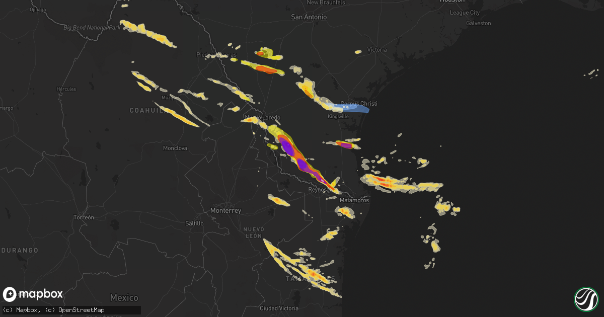
Hail Map on May 8, 2025
Get this storm
May 8 map
$229
one time, instant access
Download today. No call, no setup
Keep the $229
Bought the map and want the full workflow? Apply the entire $229 to a subscription within 7 days. None of it is wasted.
Every map, not just this one
This buys you this map. Subscription and you get every map we run, in the markets you choose from a few cities to whole states to nationwide. Plus real-time alerts the moment a storm fires.
Contact data
Name, contact info, occupancy, even credit band for addresses in the footprint. You go from where it hit to who to call.
Become the source they trust
Unlimited branding weather history reports on demand. You already have the documented answer ready for the property owner, and you are the one who showed up with it.
Property data and RoofTrace estimates
Pull up any address you have got, its value and the exact code rules for that jurisdiction, straight from One Click Code. Then RoofTrace estimates the squares, pitch, and roof value, priced the way you price.
States Impacted by Hail Map on May 8, 2025
Storm reports
Tennessee
| Date | Description |
|---|---|
| 05/08/20256:49 PM CDT | Public reported nickel to quarter size hail in crab orchard. Time estimated based on radar. |
| 05/08/20256:30 PM CDT | Quarter size hail. |
| 05/08/20256:26 PM CDT | Tennis ball size hail. |
| 05/08/20256:25 PM CDT | Photo of a large hail stone817 |
| 05/08/20256:25 PM CDT | Photo of a large hail stone estimated to be 2 inches in diameter... Via a social media post. Time is estimated from radar. |
| 05/08/20256:25 PM CDT | Ping pong ball size hail. |
| 05/08/20256:19 PM CDT | Golf ball size hail. |
| 05/08/20256:18 PM CDT | A local report indicates 1.25 inch wind near 4 ENE Pikeville |
| 05/08/20256:15 PM CDT | Golf ball size hail. |
| 05/08/20256:13 PM CDT | Quarter size hail. |
| 05/08/20256:07 PM CDT | Ping pong ball size hail. |
| 05/08/20255:58 PM CDT | Quarter size hail. |
| 05/08/20255:36 PM CDT | A local report indicates 1.00 inch wind near 4 NE Ten Mile |
| 05/08/20255:26 PM CDT | Report from mping: ping pong ball |
| 05/08/20254:59 PM CDT | Public reported quarter size hail on tramel branch rd. |
| 05/08/20254:56 PM CDT | Half dollar size hail on old liberty rd. . |
| 05/08/20254:56 PM CDT | Half dollar size hail on old liberty rd. |
| 05/08/20254:44 PM CDT | Public reported quarter to half dollar size hail on fite rd. |
| 05/08/20254:15 PM CDT | Several large branches were blown down along mcgavock pk. |
| 05/08/20254:15 PM CDT | Exact location is estimated. |
| 05/08/20254:03 PM CDT | Tspotter report shows 1 inch hail near mcgavock pike and briley parkway. |
| 05/08/20254:03 PM CDT | Tspotter report shows 1 inch hail near mcgavock pike and briley parkway. |
| 05/08/20254:00 PM CDT | Quarter size hail in ninemile. |
| 05/08/20253:58 PM CDT | Tree down on riverside drive near inglewood elementary school. |
| 05/08/20253:57 PM CDT | Quarter sized hail in inglewood tn. |
| 05/08/20253:56 PM CDT | Up to one inch hail on cahal ave. |
| 05/08/20253:55 PM CDT | A large tree was blown down at tanyard hollow rd near valley creek rd along with copious amounts of small hail. |
| 05/08/20253:55 PM CDT | A tree fell through the roof of a home on lichey ave. Time estimated from radar. |
| 05/08/20253:55 PM CDT | Half inch to one inch hail at ellington parkway and trinity ln. |
| 05/08/20253:54 PM CDT | Tspotter report showed a large tree down at cleveland park in east nashville. Time estimated from radar. |
| 05/08/20253:52 PM CDT | Tree down near the intersection of joseph ave and douglas ave. |
| 05/08/20253:45 PM CDT | Mix of quarter size 1.0 inch to golf ball 1.75 inch diameter hail that caused minor damage to vehicles. |
| 05/08/20253:40 PM CDT | Facebook report of quarter hail at wilson pk and concord rd. |
| 05/08/20253:30 PM CDT | Hail in a mixture of sizes... As large as ping pong balls. |
| 05/08/20253:30 PM CDT | Quarter sized hail in fieldstone farms... Franklin tn. Social media report. |
| 05/08/20253:28 PM CDT | 2 inch hail on hwy 96 in franklin... Tn. Reported via social media. |
| 05/08/20253:28 PM CDT | Report from mping: quarter |
| 05/08/20253:18 PM CDT | Ham radio operator reports quarter sized hail on old hillsboro rd near leipers fork. Time estimated. |
| 05/08/20253:17 PM CDT | Quarter sized hail in ashland city. Social media report. |
| 05/08/20252:59 PM CDT | A local report indicates 2.00 inch wind near 4 ESE Big Sandy |
| 05/08/20252:45 PM CDT | Hail up to quarter size was reported in charlotte. |
| 05/08/20252:35 PM CDT | A local report indicates 1.00 inch wind near 2 WSW Reagan |
| 05/08/20252:20 PM CDT | Photo of half-dollar sized hail on the west side of paris. |
| 05/08/20252:13 PM CDT | A local report indicates 1.00 inch wind near 3 SE Mifflin |
| 05/08/20252:05 PM CDT | Needmore rd and highway 200. |
| 05/08/20251:23 PM CDT | Corrects previous hail report from 4 ese big sandy. |
| 05/08/20251:14 PM CDT | Trees down on danville road. |
| 05/08/20251:13 PM CDT | Trees and power lines down on bain road. |
| 05/08/20251:13 PM CDT | A local report indicates 64 MPH wind near Big Sandy |
| 05/08/20251:13 PM CDT | A local report indicates 1.25 inch wind near Big Sandy |
| 05/08/20251:10 PM CDT | A local report indicates 1.50 inch wind near Springville |
| 05/07/20259:12 PM CDT | Report from mping: quarter |
| 05/07/20259:11 PM CDT | Quarter size hail. |
| 05/07/20258:30 PM CDT | Social media photo of hailstones up to quarter-sized. Time estimated from radar. |
| 05/07/20257:48 PM CDT | A local report indicates 1.00 inch wind near 4 NE Del Rio |
| 05/07/20257:45 PM CDT | Social media photo of very large hailstones... Estimated to be 2 inches in diameter. Time is estimated from radar. |
| 05/07/20257:40 PM CDT | A local report indicates 1.75 inch wind near 2 SE Del Rio |
| 05/07/20257:35 PM CDT | Social media photo of a very large hailstone... Estimated to be the size of a baseball. Time is estimated from radar. |
| 05/07/20257:30 PM CDT | Photo of lots of small hail around a 0.5 to 0.75 inch with the largest stones being around quarter size 1.0 inch in diameter. Time estimated by radar. |
North Dakota
| Date | Description |
|---|---|
| 05/07/20258:11 PM CDT | Asos station kmot minot airport. |
Virginia
| Date | Description |
|---|---|
| 05/08/20256:50 PM CDT | Report from mping: quarter |
| 05/08/20256:37 PM CDT | Measured with a caliper at 1.48 inches. |
| 05/08/20256:31 PM CDT | Large tree down across main street. |
| 05/08/20256:30 PM CDT | Large tree down across main street. |
| 05/08/20255:54 PM CDT | Time estimated from radar. |
| 05/08/20255:48 PM CDT | Quarter size hail |
| 05/08/20255:42 PM CDT | Corrects previous hail report from oak level. Time estimated from radar. |
| 05/08/20255:36 PM CDT | Time estimated from radar. |
| 05/08/20255:36 PM CDT | Time estimated from radar. Estimated to be 2 inches in diameter... Via a social media post. Time is estimated from radar. |
| 05/08/20255:24 PM CDT | A local report indicates 1.75 inch wind near 1 SW Bassett |
| 05/08/20255:00 PM CDT | Tree damage resulting in 15 customers without power. |
| 05/08/20254:54 PM CDT | Lasted until 6:10 pm. Start time estimated from radar. |
| 05/07/20259:45 PM CDT | Large tree downed at intersection of ashcake rd and slash dr. Time is radar estimated. |
| 05/07/20259:17 PM CDT | Power line downed at northwind place and causeway dr. Time radar estimated. |
| 05/07/20258:40 PM CDT | A local report indicates 1.00 inch wind near 5 N Natural Bridge |
| 05/07/20258:00 PM CDT | A local report indicates 1.00 inch wind near 2 WNW Stewartsville |
| 05/07/20258:00 PM CDT | A local report indicates 1.00 inch wind near 2 WNW Stewartsville |
| 05/07/20257:20 PM CDT | A large tree was blown down along runaway road. |
| 05/07/20257:19 PM CDT | Tree downed by thunderstorm winds on east elkhorn road. |
| 05/07/20257:18 PM CDT | A large tree was blown down along east elkhorn road. |
Kentucky
| Date | Description |
|---|---|
| 05/08/20256:57 PM CDT | Social media report of a tree down blocking the westbound lane of ky 476 between flintville and clayhole. Time estimated via radar. |
| 05/08/20256:57 PM CDT | Public and also media shared photos out of mcandrews... Ky showing 2 inch hail. Time estimated by radar. |
| 05/08/20256:50 PM CDT | A public report said 1 inch hail fell at the intersection open fork and bent branch rd. Time estimated from radar. |
| 05/08/20256:13 PM CDT | Picture on social media of a measured 2.5 inch hail stone found at the intersection of ky-194 and ky-1428 between 7:10 and 7:15 pm. |
| 05/08/20256:13 PM CDT | Cumberland gap national historic park made a social media post that the pinnacle road and hwy 988 sections in the park are closed until further notice due to clearing o |
| 05/08/20256:12 PM CDT | Corrects time of previous hail report from boons camp. Picture on social media of a quarter sized hail stone in boons camp. Time estimated via radar. |
| 05/08/20256:12 PM CDT | Corrects time of previous h825 local em reported estimated ping pong ball sized hail at residence and provided a photo. |
| 05/08/20256:10 PM CDT | Social media report of quarter sized hail in middlesboro at 7:10pm. |
| 05/08/20256:10 PM CDT | Social media video of large hailstones falling in emma. Size estimated to be around golf ball. Time estimated via radar. |
| 05/08/20256:00 PM CDT | Corrects previous hail report from 2 sse barboursville. Hail spotted by someone from the public and measured 1 inch. |
| 05/08/20256:00 PM CDT | Picture on social media of hail in the community of fisty. Hail was accumulating on the ground... With stones between quarter and half dollar size visible in the grass. |
| 05/08/20256:00 PM CDT | Social media picture of quarter to half dollar sized hail along south lake drive in prestonsburg. Time provided by poster and corroborated via radar. |
| 05/08/20255:48 PM CDT | Social media picture of half dollar sized hail along lotts creek road in perry county. Time estimated via radar. |
| 05/08/20255:45 PM CDT | Public posted photos of ping pong ball sized hail near the city of cordia. Time estimated by radar. |
| 05/08/20255:45 PM CDT | Social media report of measured quarter sized hail along upper second creek road in hazard. Timestamp of 6:45pm... Corroborated by radar. |
| 05/08/20255:45 PM CDT | Report from mping: quarter |
| 05/08/20255:41 PM CDT | Multiple social media pictures of quarter sized hail near woodland park in hazard. Time estimated via radar. |
| 05/08/20255:38 PM CDT | Social media pictures of quarter sized hailstones in someones hand and videos of small hail piles in gorman hollow in hazard. Time estimated via radar. |
| 05/08/20255:35 PM CDT | Social media report of quarter sized hail along browns fork road in perry county around 6:35 pm. Time corroborated via radar. |
| 05/08/20255:27 PM CDT | Video on social media of large quantities of hail falling in keaton. Quarter sized stones visible on the ground. Time estimated via radar. |
| 05/08/20255:27 PM CDT | Video on social media of lots of hail falling near the intersection of highland park avenue and the cumberland falls highway |
| 05/08/20255:16 PM CDT | Pictures of snapped telephone poles near the 1900 block of ky-225 were relayed from local ham radio operators. Time estimated from radar. |
| 05/08/20255:15 PM CDT | Re-sends previous hail report from bryants store due to iris error message. Pictures on social media of ping pong ball sized hail from 6:15 pm in the little poplar cree |
| 05/08/20255:14 PM CDT | Picture on social media of two very large hailstones near the intersection of e williamsburg street and state highway 478. They are in a womans hand and are 3 fingers w |
| 05/08/20255:07 PM CDT | Picture on social media of very large hail at mile marker 6 on williamsburg st in mccreary county near watters ridge rd. The hail is in someones hand and it is four fin |
| 05/08/20255:06 PM CDT | Social media picture of a few quarter sized hail stones in barbourville amongst piles of smaller hail on the ground. Time provided was 6:06 pm and radar corroborates th |
| 05/08/20255:05 PM CDT | Social media picture of a 2 inch hail stone near ky 700 and jennys branch road ne of whitley city. Time estimated via radar. |
| 05/08/20255:00 PM CDT | Social media report of at least quarter sized hail breaking windshields along log mountain in bell county around 6pm. |
| 05/08/20255:00 PM CDT | This is the previous hail report from 1 nw davisburg. It is in the wrong spot. The actual report was up the road closer to clear creek springs. Social media report of a |
| 05/08/20255:00 PM CDT | Trained spotter reports nickel to quarter sized hail north of whitley city. Time confirmed via radar. |
| 05/08/20254:55 PM CDT | Corrects the previous hail report from 1 nw davisburg. It was in the wrong spot. This report is now in the correct location... Up ky 190 closer to clear creek springs. |
| 05/08/20254:35 PM CDT | Hail larger than quarter size was reported near cutshin along ky 699 south of the 6 to 7 mile markers and hail of various sizes fell along the route to the perry county |
| 05/08/20254:34 PM CDT | A social media report showed a picture of a couple hail stones estimated be the size of golf balls in delta. Time estimated from radar. |
| 05/08/20254:30 PM CDT | Report from mping: golf ball |
| 05/08/20254:23 PM CDT | Social media picture of hail covering the ground north of keavy along 192. Majority of the stones are closer to quarter sized... But a few significantly larger stones a |
| 05/08/20254:20 PM CDT | Hail estimated at quarter size was reported to have fallen near the intersection of ky 1780 |
| 05/08/20254:20 PM CDT | Picture on social media of piles of melting large hail along michigan avenue in monticello. Some of the storms are at least quarter sized still... And the entirety of t |
| 05/08/20254:20 PM CDT | Hail estimated at quarter size was reported to have fallen near the intersection of ky 1780 and us 421. The event time is radar estimated. |
| 05/08/20254:15 PM CDT | Corrects time. Re-sends previous hail report from bryants store due to iris error message. Pictures on social media of ping pong ball sized hail from 5:15 pm in the lit |
| 05/08/20254:15 PM CDT | Multiple pictures of baseball sized hail in monticello. One such stone was near the intersection of hwy 3285/hwy 776. Time estimated via radar. |
| 05/08/20254:13 PM CDT | Pictures on social media of quarter to ping pong ball sized hail in essie. Time estimated via radar. |
| 05/08/20254:12 PM CDT | Pictures on social media of structure damage along cherry street in monticello from the large hail that fell. Multiple broken windows and tattered vinyl siding visible. |
| 05/08/20254:12 PM CDT | Picture on social media of a quarter sized hail stone in boons camp. Time estimated via radar. |
| 05/08/20254:12 PM CDT | Multiple reports of broken windows and damaged vinyl siding in monticello from the large hail this evening. At a residence along bob carrender road... There were photos |
| 05/08/20254:11 PM CDT | Large amounts of ping pong ball sized hail reported near the doughboy statue in downtown monticello. Time estimated via radar. |
| 05/08/20254:11 PM CDT | A local report indicates 1.00 inch wind near 1 SW Monticello |
| 05/08/20254:05 PM CDT | Trained spotter reported estimated golf ball size hail. Time estimated from radar. |
| 05/08/20253:41 PM CDT | Social media picture of golf ball sized hail on jacks fork road off 26. Time estimated via radar. |
| 05/08/20253:36 PM CDT | Delayed social media report of half dollar sized hail in rockholds. Report passed on by skywarn ham network. Time estimated via radar. |
| 05/08/20253:35 PM CDT | Hailstones ranging in size between 1.5 inches and 2.5 inches fell. |
| 05/08/20253:30 PM CDT | A local report indicates 1.00 inch wind near Goldbug |
| 05/08/20253:28 PM CDT | Report from mping: quarter |
| 05/08/20253:15 PM CDT | Social media video of lots of hail falling near the intersection of hooppole creek road and marydell road in eastern laurel county around 4:15 pm. Time confirmed by rad |
| 05/08/20253:06 PM CDT | Public shared video of small hailstones... With larger quarter sized hail embedded. This occurred on ky-225 in trosper near the intersection of number one hollow road. |
| 05/08/20253:05 PM CDT | Public report of 1.00 inch measured hail nw of fourmile... Time estimated via radar. |
| 05/08/20253:03 PM CDT | Social media pictures of at least egg sized hail in trosper around 4pm. The hail broke car windshields. Time estimated to be 4:03pm via radar. |
| 05/08/20253:03 PM CDT | Trained spotter reported half dollar sized hail at the intersection of east jellico road and ky 92. Time estimated via radar. |
| 05/08/20253:02 PM CDT | Public emailed picture of half dollar sized hail. |
| 05/08/20252:54 PM CDT | Public report of golf ball sized hail. |
| 05/08/20252:54 PM CDT | Public report of golf ball sized hail. |
| 05/08/20252:50 PM CDT | Picture of multiple hailstones compared with a penny ne of london. The largest stones are at least double the size of the penny. Time estimated via radar. |
| 05/08/20252:40 PM CDT | Damage to residence home near boxville. Shingle damage along with downspouts and gutters torn away from home. Hvac was turned on its side as well. |
| 05/08/20252:31 PM CDT | Public report of ping pong sized hail. |
| 05/08/20252:31 PM CDT | A local report indicates 2.00 inch wind near Utica |
| 05/08/20252:31 PM CDT | A local report indicates 1.00 inch wind near 1 ESE Morganfield |
| 05/08/20252:27 PM CDT | Public report of quarter sized hail. |
| 05/08/20252:16 PM CDT | Public report of quarter sized hail. |
| 05/08/20251:54 PM CDT | Trained spotter reported ping pong sized hail at the intersection of ky 187 and pine ridge dr. In sw grayson county. |
| 05/08/202512:38 PM CDT | Emergency manager reported golf ball sized hail. |
| 05/08/202512:30 PM CDT | Machine shop in mchenry reported quarter size hail. |
| 05/07/20257:05 PM CDT | Picture on social media of half dollar sized hail in pinsonfork... Ky. Time estimated via radar. |
| 05/07/20257:03 PM CDT | Social media picture of a measured 1 inch hailstone along upper blackberry road southwest of ransom... Ky. Time estimated via radar. |
| 05/07/20257:00 PM CDT | A picture of estimated golf ball sized hail was sent to the office from belfry. Time estimated from radar. |
| 05/07/20257:00 PM CDT | Social media report of hail along riley branch road... Near flint ridge cemetery. Mostly smaller stones... But a couple of quarters mixed in. Time provided by reporter. |
Texas
| Date | Description |
|---|---|
| 05/08/20256:49 PM CDT | Pictures and video on x showed ping pong to golfball size hail north of rio grande city. |
| 05/08/20256:39 PM CDT | Report from mping: golf ball |
| 05/08/20256:24 PM CDT | Ranch owner sent video of estimated quarter sized hail. |
| 05/08/20256:10 PM CDT | Two tractor trailers blown over 5 ssw of town |
| 05/08/20255:45 PM CDT | Corrects previous tstm wnd dmg report from 3 ese carrizo springs. Structural damage to front porch and sideways bent 10 foot post that is secured to the ground; broken |
| 05/08/20255:40 PM CDT | 500 acres of corn destroyed. |
| 05/08/20255:35 PM CDT | Hail up to quarter size at intersection of us 83 and us 277. Time estimated via radar. |
| 05/08/20255:35 PM CDT | 3 to 6 inch diameter branches snapped off a tree in carrizo springs near intersection of us 83 and us 277; in addition to the 1 inch diameter hail. |
| 05/08/20255:33 PM CDT | Snapped power poles and signage at td rentals on hwy 277 in carrizo springs. Time estimated via radar. |
| 05/08/20254:56 PM CDT | Report of estimated baseball hail size received by trained storm spotter at the intersection of fm2687 and fm649. |
| 05/08/20253:45 PM CDT | Structural damage to front porch and sideways bent 10 foot post that is secured to the ground; broken window from possible wind debris or hail as well. |
| 05/08/20253:05 PM CDT | Broadcast media shared resident report of estimated 1 inch hail in weslaco. Time estimated based on radar data. |
| 05/08/20253:05 PM CDT | Broadcast media shared resident report of estimated 1 inch hail in weslaco. Time estimated based on radar data. |
| 05/08/20253:04 PM CDT | Mesonet station rget2 bibe rgv. |
| 05/08/20253:00 PM CDT | Mesonet station twb98 gray ranch. |
| 05/08/20252:52 PM CDT | Broadcast media shared video from resident with estimated quarter-sized hail at the intersection of mile 9 and 1015. |
| 05/08/20252:52 PM CDT | Broadcast media shared video from resident with estimated quarter-sized hail at the intersection of mile 9 and 1015. |
| 05/07/202511:02 PM CDT | Multiple accidents reported along us 77. 2 18 wheelers flipped southbound. 1 18 wheeler reported flipped northbound. |
| 05/07/202510:38 PM CDT | Multiple power lines and transmission lines down throughout the city of driscoll. |
| 05/07/202510:29 PM CDT | Public reported overturned 18 wheeler at us-77 and fm 665. |
| 05/07/202510:05 PM CDT | Mobile home blown off foundation into the street... Roof blown off carport. |
| 05/07/202510:00 PM CDT | Large trees uprooted. |
| 05/07/20259:46 PM CDT | Reported that their hurricane fence was blown over with lots of tree limbs down. Time was estimated on radar. |
| 05/07/20259:45 PM CDT | 30 ft tree uprooted causing damage to house roof and siding near la paloma off of cr 18 and cr 93. |
| 05/07/20259:39 PM CDT | Member of the public provided facebook photo comment showing approximately 2 inch hail. |
| 05/07/20259:35 PM CDT | 80 transmission lines blown down upon survey. Time estimated from radar. |
| 05/07/20259:30 PM CDT | Received phone call of a power outage... Mobile homes being blown into the street... Blown off roofs and collapsed carports in petronila. Time is estimated. |
| 05/07/20259:30 PM CDT | Received phone call report of trees snapped. An anchored playground was broken... Roof blown off and multiple area of roof damage. |
| 05/07/20259:30 PM CDT | Pictures of barn roof damage from social media. Time is estimated. |
| 05/07/20259:25 PM CDT | Large trees snapped... Playground equipment broken... Roof blown off into nearby field. |
| 05/07/20259:17 PM CDT | Also reported pea-sized hail. |
| 05/07/20259:17 PM CDT | Report of two tractor trailers flipped over on hwy 281 and fm 1554. |
| 05/07/20259:17 PM CDT | Reports received through em of a barn demolished on fm 1554. |
| 05/07/20259:17 PM CDT | Reports of downed power lines and trees throughout the city of alice. |
| 05/07/20259:17 PM CDT | Asos station kali alice- pk wind time report differs from the actual passage of strong winds... So time on this report is estimated on radar. |
| 05/07/20259:14 PM CDT | Two to three ft diameter tree blown over and possibly hit with lightning. |
| 05/07/20259:10 PM CDT | Many uprooted trees and downed power poles. |
| 05/07/20259:00 PM CDT | Roof blown off of a horse barn and several large trees down. Report received via phone call. |
| 05/07/20259:00 PM CDT | Public report from social media: lost a barn and several homes lost parts of their roof. Time is estimated. |
| 05/07/20259:00 PM CDT | Photos received on social media of a collapsed metal building structure. |
| 05/07/20258:48 PM CDT | Video recording of metal shed/garage blown over with damage to farming equipment/vehicles. Time estimated off radar. |
| 05/07/20258:09 PM CDT | Report received via fb. Also recorded 1.4 inches of rainfall. Time estimated from radar. |
| 05/07/20258:03 PM CDT | Duval county ems reported a jack-knifed 18 wheeler n of freer. |
| 05/07/20257:50 PM CDT | Member of the public posted facebook photo verified location based on radar of a hailstone approximately 1.5 inches. |
| 05/07/20257:31 PM CDT | Trained spotted reported receiving estimated golf ball sized hail on vehicle driving on the expressway just ne of donna. |
| 05/07/20257:24 PM CDT | Member of the public posted facebook photo |
| 05/07/20257:18 PM CDT | A local report indicates 1.00 inch wind near 3 S Edinburg |
| 05/07/20257:18 PM CDT | Member of the public pasted a facebook comment of a photo of hailstone approximately 3 inches long and 1.5 inches wide. |
| 05/07/20257:18 PM CDT | Trained skywarn spotter reported golf ball sized hail around the intersection of wisconsin and veterans. |
| 05/07/20257:18 PM CDT | Member of the public posted a facebook photo comment showing an approximately golf ball sized hailstone taken at this location. |
| 05/07/20257:17 PM CDT | Report from mping: half dollar |
| 05/07/20257:15 PM CDT | Member of the public posted facebook photo comment with location and timestamp... Approximately 1 inch. |
| 05/07/20257:12 PM CDT | Member of the public left a facebook comment with video showing approximately golf ball sized hail at this intersection. Reported minor vehicle damage... As well as dam |
| 05/07/20257:10 PM CDT | Member of the public posted a photo comment via facebook showing approximately 1 inch hail. |
| 05/07/20257:10 PM CDT | Member of the public sent a photo through a facebook message showing hailstones approximately 2 inches. |
| 05/07/20257:10 PM CDT | Photo received from dhr health of a 2 inch sized measured hailstone that fell near dove and mccoll. |
| 05/07/20257:08 PM CDT | Member of the public posted facebook photo comment showing approximately golf ball sized hailstone. |
| 05/07/20257:07 PM CDT | Local em reported estimated ping pong ball sized hail at residence and provided a photo. |
| 05/07/20257:05 PM CDT | Member of the public sent photos through facebook message showing approximately golf ball-sized hail. |
| 05/07/20257:05 PM CDT | Report received from ham operator of 1 inch estimated hail falling for 10 minutes duration. |
| 05/07/20257:00 PM CDT | Member of the public posted facebook video of downed fence and trees. |
Alabama
| Date | Description |
|---|---|
| 05/08/20256:45 PM CDT | 1.5 inch hail on 87 towards zion chapel. Reported by public via social media. |
| 05/08/20256:40 PM CDT | Photos and videos on social media of hail around quarter size north of elba. |
| 05/08/20255:18 PM CDT | Numerous trees reported down between hwy 13 and hwy 5 in winston county. Time estimated by radar. |
| 05/08/20254:48 PM CDT | Public reports hail estimated to be quarter-sized with 2nd storm that moved over the location. Time estimated by radar. |
| 05/07/20258:06 PM CDT | Quarter size hail reported in boley springs. |
| 05/07/20257:58 PM CDT | A few trees were downed by outflow winds in the springfield community north of eutaw. |
| 05/07/20257:50 PM CDT | Quarter sized hail covering ground near union. Time estimated by radar. |
| 05/07/20257:25 PM CDT | Social media report of multiple trees down in the tabernacle area. |
| 05/07/20257:16 PM CDT | Public reported hail up to quarter-sized along cr 79. |
| 05/07/20257:14 PM CDT | Up to golf ball size hail in the tarentum/hamilton crossroads area. |
| 05/07/20257:10 PM CDT | Photo on social media of hail estimated at 2 inches in diameter from the roeton area in northeast coffee county. |
| 05/07/20257:10 PM CDT | Golf ball and larger size hail reported by ham skywarn spotter near the county line. |
| 05/07/20257:00 PM CDT | Public reported quarter size hail near victoria al via social media. Picture with quarter for comparison. |
Massachusetts
| Date | Description |
|---|---|
| 05/08/20255:40 PM CDT | Corrects previous hail report from west brookfield. |
| 05/07/20257:06 PM CDT | A local report indicates 1.00 inch wind near West Brookfield |
Missouri
| Date | Description |
|---|---|
| 05/08/20251:57 PM CDT | [landspout] public photo of a relatively robust looking landspout near wyatt... Mo. No damage reports have been received as of yet. |
| 05/08/20251:54 PM CDT | A local report indicates 1.75 inch wind near 1 ENE Wilson City |
North Carolina
| Date | Description |
|---|---|
| 05/08/20256:56 PM CDT | Tree down on car. |
| 05/08/20256:45 PM CDT | Mping user reported quarter-sized |
| 05/08/20256:40 PM CDT | Tree down on swicegood road. |
| 05/08/20256:35 PM CDT | A local report indicates 1.25 inch wind near Kings Mountain |
| 05/08/20256:31 PM CDT | Tree downed by thunderstorm winds on taylor road near stoneville. |
| 05/08/20256:20 PM CDT | Tree down off of u.s. 64. |
| 05/08/20256:16 PM CDT | Mping user reported quarter-sized |
| 05/08/20256:11 PM CDT | A tree was blown down off of smith road near the intersection with anglin mill road. |
| 05/08/20256:08 PM CDT | Half dollar size hail reported in the area of traphill in north carolina via social media picture. |
| 05/08/20255:56 PM CDT | Quarter size |
| 05/08/20255:50 PM CDT | Mping user reported half-dollar sized |
| 05/08/20255:46 PM CDT | 1.00 inch hail reported in the millers creek north carolina area via social media. |
| 05/08/20255:45 PM CDT | A local report indicates 1.50 inch wind near 1 NW Mulberry |
| 05/08/20255:33 PM CDT | A local report indicates 1.50 inch wind near 1 N Rutherfordton |
| 05/08/20255:24 PM CDT | A local report indicates 1.00 inch wind near Cashiers |
| 05/08/20255:22 PM CDT | A local report indicates 1.00 inch wind near 3 SSW Cooksville |
| 05/08/20255:22 PM CDT | A local report indicates 1.00 inch wind near 4 N Spindale |
| 05/08/20255:20 PM CDT | Public reported quarter-sized |
| 05/08/20255:17 PM CDT | Mping user reported quarter-sized |
| 05/08/20254:50 PM CDT | Dime to quarter size hail in dobson lasted for 10 to 15 minutes. |
| 05/08/20254:45 PM CDT | Hailed for 15 min. |
| 05/08/20254:39 PM CDT | Corrects previous hail report from 2 nnw rutherfordton. |
| 05/08/20254:37 PM CDT | A local report indicates 1.00 inch wind near Forest City |
| 05/08/20254:30 PM CDT | A local report indicates 1.00 inch wind near 2 SSE Patterson |
| 05/08/20254:29 PM CDT | Multiple trees down. |
| 05/08/20254:25 PM CDT | Alexander county emergency management reported three trees fell onto power lines in the sugarloaf mountain community. Time estimated from radar. |
| 05/08/20254:19 PM CDT | A local report indicates 1.75 inch wind near 1 W Hudson |
| 05/08/20254:18 PM CDT | Time estimated from radar. |
| 05/08/20254:10 PM CDT | Quarter size hail. |
| 05/08/20253:57 PM CDT | Tree reported down across the roadway at the intersection of pike road and wild cat road in moravian falls north carolina. |
| 05/08/20253:55 PM CDT | A local report indicates 1.50 inch wind near Woodfin |
| 05/08/20253:55 PM CDT | A local report indicates 1.50 inch wind near Woodfin |
| 05/08/20253:54 PM CDT | A local report indicates 1.00 inch wind near Old Fort |
| 05/08/20253:54 PM CDT | Time estimated from radar. |
| 05/08/20253:51 PM CDT | A local report indicates 1.00 inch wind near Sawmills |
| 05/08/20253:49 PM CDT | A local report indicates 1.00 inch wind near Dysartsville |
| 05/08/20253:40 PM CDT | Mping user reported quarter-sized hail. Report time verified by radar. And us 421. The event time is radar estimated. |
| 05/08/20253:40 PM CDT | Mping user reported quarter-sized |
| 05/08/20253:37 PM CDT | Broadcast media reported a viewer near swannanoa received golf-ball sized |
| 05/08/20253:35 PM CDT | A local report indicates 1.00 inch wind near 3 WSW Woodfin |
| 05/08/20253:28 PM CDT | Mping user reported quarter-sized |
| 05/08/20253:25 PM CDT | Video of golf ball size hail near downtown asheville via social media. |
| 05/08/20253:25 PM CDT | A local report indicates 1.00 inch wind near Marion |
| 05/08/20253:25 PM CDT | Reports and pictures of quarter size hail near woodfin... North carolina. |
| 05/08/20253:21 PM CDT | Mping user reported ping-pong ball |
| 05/08/20253:20 PM CDT | A local report indicates 1.00 inch wind near Morganton |
| 05/08/20253:20 PM CDT | Mping user reported quarter-sized |
| 05/08/20253:20 PM CDT | Emergency management reports golf ball sized hail. |
| 05/08/20253:17 PM CDT | Mping user reported quarter-sized |
| 05/08/20253:15 PM CDT | A local report indicates 1.00 inch wind near 1 NNW Downtown Ashevill |
| 05/08/20253:07 PM CDT | Mping user reported quarter-sized |
| 05/08/20252:47 PM CDT | A local report indicates 1.00 inch wind near 4 SSE Luck |
| 05/08/20252:40 PM CDT | Cocorahs observer reported pea-sized to half-dollar sized hail. Report time verified by radar. |
| 05/07/20259:05 PM CDT | Tree down on powerlines. |
| 05/07/20258:55 PM CDT | Tree down on doyle cox road. Report from scanner. |
| 05/07/20258:45 PM CDT | Tree down on minter school road. Report from scanner. |
| 05/07/20258:45 PM CDT | Mobile spotter reports numerous trees down along route 24 between carthage and cameron. |
| 05/07/20258:40 PM CDT | Tree down on south franklin drive. Report from scanner. |
| 05/07/20258:15 PM CDT | Tree down on candor-troy road. |
| 05/07/20258:00 PM CDT | Tree and limbs down resulting in power outage near nc 24/27. |
| 05/07/20257:50 PM CDT | Tree down resulting in power outage near ether. |
| 05/07/20257:50 PM CDT | Tree down on the 6600 block of clyde king road. Report via randolph co 911 email. |
| 05/07/20257:46 PM CDT | Multiple trees... Snapped power pole and powerlines down. |
| 05/07/20257:46 PM CDT | Multiple trees... Snapped power pole and powerlines down. |
| 05/07/20257:45 PM CDT | Large tree blocking both lanes on brady street extension. Report from randolph co 911 email. |
| 05/07/20257:45 PM CDT | Tree down on utility lines. |
| 05/07/20257:35 PM CDT | Tree down in the road blocking travel near old route 13 and old cox road. |
| 05/07/20257:29 PM CDT | Fallen trees and limbs on powerlines. |
| 05/07/20257:20 PM CDT | Tree down in road near the intersection of sharon avenue and portage parkway. Report via email from randolph co 911. |
| 05/07/20257:02 PM CDT | Mping user reported quarter-sized |
| 05/07/20257:00 PM CDT | Tree down on the 37600 block of pauls crossing road. |
Florida
| Date | Description |
|---|---|
| 05/08/20255:05 PM CDT | Trained spotter in edgewater reported hail the size of nickels and quarters |
| 05/08/20254:08 PM CDT | Trained spotter was located at sr-414 and marden rd. |
Mississippi
| Date | Description |
|---|---|
| 05/08/20254:29 PM CDT | Multiple trees and powerlines down on fire station rd and lock hill rd. Report relayed via broadcast media. |
| 05/08/20254:29 PM CDT | Multiple trees down along highway 182 corridor from maben to old westpoint rd. |
| 05/08/20254:16 PM CDT | Ping-pong ball size hail reported near walmart marketplace on hwy 12 in starkville. |
| 05/08/20254:06 PM CDT | Large tree down near hospital road in starkville. |
| 05/08/20254:05 PM CDT | Minor shingle and gutter damage at apt. Complex at msu. Few trees blown down. Estimated wind gusts 60 mph. |
| 05/08/20254:05 PM CDT | A local report indicates 1.75 inch wind near 2 NE Starkville |
| 05/08/20254:05 PM CDT | 2.25 inch hail reported on old west point rd between i-82 and martin king jr dr. Report relayed via storm chaser. |
| 05/08/20254:04 PM CDT | Golf ball size hail at msu research park. |
| 05/08/20254:03 PM CDT | Tree on a house on box end rd w. |
| 05/08/20254:03 PM CDT | Multiple trees downed in between old west point rd and martin luther king jr dr. |
| 05/08/20253:58 PM CDT | Ping pong size hail at fire station 3. Report relayed via broadcast media. |
| 05/08/20253:55 PM CDT | Numerous 2+ inch branches down. Intermittent pea size hail reported. |
| 05/08/20253:55 PM CDT | Corrects previous tstm wnd dmg report from 1 n starkville. Estimated wind gusts around 60 to 65 mph. Numerous 2+ inch branches down. Intermittent pea size hail reported |
| 05/08/20253:33 PM CDT | A local report indicates 1.00 inch wind near Maben |
| 05/08/20253:30 PM CDT | Local law enforcement reported multiple down trees and powerlines across maben ms. Five homes had minor storm damage. |
| 05/08/20252:45 PM CDT | A local report indicates 1.00 inch wind near 5 S Mantachie |
| 05/08/20252:12 PM CDT | Quarter-sized hail just south of tupelo high school. |
| 05/08/20252:06 PM CDT | Corrects previous hail report from 3 e furrs. Golf ball-sized hail on the pontotoc-lee county line along highway 6. |
| 05/08/20252:00 PM CDT | Photo of 2 inch hail in the furrs community. |
| 05/08/20251:51 PM CDT | Quarter-sized hail in the black zion community. |
Georgia
| Date | Description |
|---|---|
| 05/08/20255:45 PM CDT | [landspout] a video was relayed via social media showing a landspout near moody altman rd in baxley... Ga. No damage was reported by the appling county em. |
| 05/08/20255:39 PM CDT | A photo of hail was shared by the appling county em which estimated to be quarter sized. They also reported pea to nickel size hail fell in the baxley area. |
| 05/08/20252:32 PM CDT | A local report indicates 1.00 inch wind near 1 SSE Halfmoon Landing |
| 05/08/20251:14 PM CDT | Video relayed via social media shows quarter size hail on i-16 by the sinkhole road overpass. Time estimated from radar. |
| 05/07/20259:51 PM CDT | Report from mping: golf ball |
| 05/07/20259:50 PM CDT | Report from mping: ping pong ball |
| 05/07/20259:49 PM CDT | Report of 1.75 inch hail relayed via local emergency management near the intersection of bells ferry rd and high pointe dr. |
| 05/07/20259:48 PM CDT | 1.25 inch hail reported along 10 block of rowland springs ct near ga hwy 20. |
| 05/07/20259:47 PM CDT | Report from mping: ping pong ball |
| 05/07/20259:42 PM CDT | Report from mping: half dollar |
| 05/07/20259:35 PM CDT | A local report indicates 1.50 inch wind near 1 SW Cassville |
| 05/07/20259:32 PM CDT | Public called to report quarter sized hail between cassville and cartersville... Ga. |
| 05/07/20258:05 PM CDT | A few trees and a power line down near intersection of mask and brady road se of americus. |
West Virginia
| Date | Description |
|---|---|
| 05/08/20256:35 PM CDT | Tree damage resulting in 75 customers without power. |
| 05/08/20256:32 PM CDT | Tree down blocking spruce laurel road in clothier. Time estimated from radar. |
| 05/08/20256:10 PM CDT | Tree down on perry branch road in chapmanville. |
| 05/08/20256:10 PM CDT | A local report indicates 1.00 inch wind near Chapmanville |
| 05/08/20256:07 PM CDT | Tree down blocking entire road. Time estimated by radar. |
| 05/08/20256:05 PM CDT | One tree down on fort gay road in wayne county near route 37. Time estimated by radar. |
| 05/08/20256:00 PM CDT | Hail spotted by someone from the public and measured 1 inch. |
| 05/08/20256:00 PM CDT | Hail spotted by someone from the public and measured 1 inchlth of a 2 inch sized measured hailstone that fell near dove and mccoll. |
| 05/08/20254:55 PM CDT | Tree damage resulting in 295 customers without power. |
| 05/07/20257:35 PM CDT | Tree blocking one lane on coal river road. |
| 05/07/20257:29 PM CDT | Tree down blocking both lanes on the logan side of horsepen. Time estimated from radar. |
| 05/07/20257:25 PM CDT | Tree damage resulting in 150 customers without power. |
| 05/07/20257:21 PM CDT | Corrects previous tstm wnd gst report from 6 ne red jacket. Corrects previous non-tstm wnd gst report from 6 ne red jacket. Mesonet station ragw2 ragland. |
South Carolina
| Date | Description |
|---|---|
| 05/08/202512:33 AM CDT | Trained spotter sent pictures of at least quarter sized hail that was falling around 1:33 am. |
| 05/07/20258:38 PM CDT | A local report indicates 1.25 inch wind near 1 S Rock Hill |
| 05/07/20258:30 PM CDT | A local report indicates 1.00 inch wind near 2 SSW Lake Wylie |
| 05/07/20258:15 PM CDT | A local report indicates 1.00 inch wind near 6 WNW Rock Hill |
| 05/07/20258:14 PM CDT | Mping user reported half-dollar sized |
| 05/07/20257:52 PM CDT | Mping user reported quarter-sized |
| 05/07/20257:47 PM CDT | Mping user reported half-dollar sized |
Cities Impacted by Hail Map on May 8, 2025
- Bristol, FL
- Eastpoint, FL
- Rio Hondo, TX
- South Padre Island, TX
- Menard, TX
- Brady, TX
- Marathon, TX
- Fort Stockton, TX
- East Prairie, MO
- Gleason, TN
- Centertown, KY
- Beaver Dam, KY
- McHenry, KY
- McKenzie, TN
- Henry, TN
- Paris, TN
- Dryden, TX
- Eldorado, IL
- Raleigh, IL
- Springville, TN
- Mansfield, TN
- Register, GA
- Metter, GA
- Big Sandy, TN
- Sikeston, MO
- Brooklet, GA
- Pembroke, GA
- Cromwell, KY
- Horse Branch, KY
- Stewart, TN
- Waverly, TN
- Statesboro, GA
- Martin, TN
- Sharon, TN
- Fillmore, IN
- Cloverdale, IN
- Greencastle, IN
- Henderson, KY
- Robards, KY
- Sylvania, GA
- Harrisburg, IL
- Tennessee Ridge, TN
- Erin, TN
- Owensboro, KY
- Calhoun, KY
- Bertrand, MO
- Charleston, MO
- Pontotoc, MS
- Equality, IL
- Savannah, GA
- Hardeeville, SC
- Morgantown, KY
- Dresden, TN
- Ellabell, GA
- Tupelo, MS
- Belden, MS
- Comstock, TX
- Pinson, TN
- Junction, IL
- Morganfield, KY
- Puryear, TN
- Bluffton, SC
- Okatie, SC
- Herod, IL
- Caneyville, KY
- Leitchfield, KY
- Brownsville, KY
- Utica, KY
- Uniontown, KY
- Port Wentworth, GA
- Blue Springs, MS
- Henderson, TN
- Beech Bluff, TN
- Buchanan, TN
- Bee Spring, KY
- Clarkson, KY
- Waverly, KY
- Clay, KY
- Williamsburg, KY
- Jacks Creek, TN
- Midway, GA
- Reagan, TN
- Luray, TN
- Huron, TN
- Vanleer, TN
- McEwen, TN
- Plantersville, MS
- Bloomingdale, GA
- Hardyville, KY
- Canmer, KY
- Greensburg, KY
- Rutherfordton, NC
- Lake Lure, NC
- Mill Spring, NC
- Siler, KY
- Riceboro, GA
- Fulton, MS
- Mooreville, MS
- Leicester, NC
- Cumberland Furnace, TN
- Enville, TN
- Hot Springs, NC
- Donna, TX
- Okolona, MS
- Pooler, GA
- Mantachie, MS
- Hohenwald, TN
- Lexington, TN
- Sardis, TN
- Scotts Hill, TN
- Decaturville, TN
- Bath Springs, TN
- Charlotte, TN
- Nettleton, MS
- Pineville, KY
- Barbourville, KY
- Trosper, KY
- Weslaco, TX
- Dickson, TN
- Mercedes, TX
- Richmond Hill, GA
- Fort Stewart, GA
- Summertown, TN
- Guyton, GA
- Drakesboro, KY
- Central City, KY
- White Bluff, TN
- Ashland City, TN
- Union Mills, NC
- Mount Pleasant, TN
- Rockholds, KY
- Hendersonville, NC
- Kilmichael, MS
- Medon, TN
- Asheville, NC
- Alexander, NC
- Franklin, TN
- Marion, NC
- Fourmile, KY
- Twin City, GA
- Crossville, TN
- Pikeville, TN
- Marianna, FL
- Fletcher, NC
- Clifton, TN
- Linden, TN
- Nebo, NC
- Brentwood, TN
- Campbellsville, KY
- Eupora, MS
- Mathiston, MS
- Lancing, TN
- Winter Haven, FL
- Flat Lick, KY
- Wilkesboro, NC
- Fairview, NC
- Morganton, NC
- Amory, MS
- Hilham, TN
- Celina, TN
- Rockport, KY
- Edcouch, TX
- Santa Rosa, TX
- Laredo, TX
- Ferguson, NC
- Boomer, NC
- Maben, MS
- Pheba, MS
- Starkville, MS
- Swannanoa, NC
- Nashville, TN
- Walker, KY
- Stewart, MS
- French Camp, MS
- Quemado, TX
- Allons, TN
- Old Fort, NC
- Woodbine, KY
- Townsend, GA
- Corbin, KY
- Black Mountain, NC
- Smithville, MS
- Lynnville, TN
- Waynesboro, TN
- San Ygnacio, TX
- Auburndale, FL
- Artemus, KY
- Bremen, KY
- Harlingen, TX
- Antioch, TN
- Whites Creek, TN
- Madison, TN
- Bryants Store, KY
- Moravian Falls, NC
- Robbins, TN
- Somerset, KY
- Portal, GA
- Culleoka, TN
- Hudson, NC
- Granite Falls, NC
- Beverly, KY
- Stoney Fork, KY
- Helton, KY
- Manchester, KY
- Arlington, KY
- Clinton, KY
- Toone, TN
- Bolivar, TN
- Crystal City, TX
- Albany, KY
- Alpha, KY
- Weir, MS
- Bardwell, KY
- Garfield, GA
- Warbranch, KY
- Apopka, FL
- Mozelle, KY
- Roark, KY
- Ocoee, FL
- Essie, KY
- Stinnett, KY
- Big Creek, KY
- Hyden, KY
- London, KY
- Bostic, NC
- Monticello, KY
- Bimble, KY
- Marble, NC
- Murphy, NC
- Huntsville, TN
- Greenwood Springs, MS
- Byrdstown, TN
- Detroit, AL
- Hornsby, TN
- Bethel Springs, TN
- Hebbronville, TX
- Kingston Springs, TN
- Pegram, TN
- Zapata, TX
- Eagle Pass, TX
- Tremont, MS
- Lewisburg, TN
- Hermitage, TN
- Joelton, TN
- West Point, MS
- Columbus, MS
- Centerville, TN
- Santa Fe, TN
- Williamsport, TN
- Duck River, TN
- Primm Springs, TN
- Orlando, FL
- Keavy, KY
- Lenoir, NC
- Mount Juliet, TN
- Lawrenceburg, TN
- Taylorsville, NC
- Pioneer, TN
- Forest City, NC
- Beaverton, AL
- Sulligent, AL
- Burkesville, KY
- Gerton, NC
- Chappell, KY
- Jackson, TN
- Valdese, NC
- Douglas, GA
- Lebanon, TN
- Old Hickory, TN
- La Vergne, TN
- Whitleyville, TN
- Wartburg, TN
- Guerra, TX
- Connelly Springs, NC
- Guin, AL
- Hamilton, AL
- Ethridge, TN
- Tazewell, TN
- North Wilkesboro, NC
- Roaring River, NC
- Watertown, TN
- Armstrong, TX
- Yeaddiss, KY
- Wooton, KY
- Lily, KY
- Lascassas, TN
- Murfreesboro, TN
- Newcomb, TN
- Alexandria, TN
- Liberty, TN
- Auburntown, TN
- Smyrna, TN
- Nolensville, TN
- Gray, KY
- Hickory, NC
- Brilliant, AL
- Heidrick, KY
- Winfield, AL
- Fort Gay, WV
- La Follette, TN
- Haysi, VA
- Big Rock, VA
- Breaks, VA
- Whitley City, KY
- Calvin, KY
- Milton, TN
- Edgewater, FL
- New Smyrna Beach, FL
- Ellenboro, NC
- Mooresboro, NC
- Hiddenite, NC
- Pisgah Forest, NC
- Darien, GA
- Nicholls, GA
- West Green, GA
- Hamptonville, NC
- Stafford, VA
- Winfield, TN
- Gotha, FL
- Stearns, KY
- Dowelltown, TN
- Jellico, TN
- Goliad, TX
- Casar, NC
- Genoa, WV
- Wayne, WV
- Shelby, NC
- Lawndale, NC
- Carrizo Springs, TX
- Oak Hill, FL
- Encino, TX
- Middlesboro, KY
- Elkfork, KY
- Mills River, NC
- Alma, GA
- Horse Shoe, NC
- East Lynn, WV
- Dunlow, WV
- Kiahsville, WV
- Sandy Hook, KY
- Isonville, KY
- West Liberty, KY
- Martha, KY
- Keaton, KY
- Flatgap, KY
- Ranger, WV
- Ethelsville, AL
- Baker, FL
- Vale, NC
- Arden, NC
- Cashiers, NC
- Highlands, NC
- Batesville, TX
- Baxley, GA
- Miracle, KY
- Lynn, AL
- Nauvoo, AL
- Savannah, TN
- Cherryville, NC
- Roma, TX
- Andrews, NC
- Pine Knot, KY
- Rio Grande City, TX
- Lincolnton, NC
- Spindale, NC
- Stuart, VA
- Bassett, VA
- Henry, VA
- Harts, WV
- Branchland, WV
- Chapmanville, WV
- Blaine, KY
- Sitka, KY
- Stambaugh, KY
- College Grove, TN
- Arrington, TN
- Sapphire, NC
- Osteen, FL
- Hazard, KY
- Laurel Hill, FL
- Carrollton, AL
- Reform, AL
- Grover, NC
- Purlear, NC
- Millers Creek, NC
- Mims, FL
- Glenville, NC
- Sunbright, TN
- Dilley, TX
- Sanford, FL
- Patrick Springs, VA
- Scalf, KY
- Warren, MA
- West Brookfield, MA
- Cotulla, TX
- Critz, VA
- Spencer, VA
- Dobson, NC
- Elkin, NC
- Mount Airy, NC
- Sassafras, KY
- Big Creek, WV
- McGrady, NC
- Lowmansville, KY
- Louisa, KY
- Hays, NC
- Prestonsburg, KY
- Carrie, KY
- Hindman, KY
- Santa Elena, TX
- Sweetwater, TN
- Philadelphia, TN
- Big Wells, TX
- Asherton, TX
- Catarina, TX
- Lake Toxaway, NC
- Ten Mile, TN
- Andalusia, AL
- Florala, AL
- Spring City, TN
- Martinsville, VA
- Frakes, KY
- Rocky Mount, VA
- Lutts, TN
- Collinwood, TN
- Jacksonville, GA
- Glade Hill, VA
- Kings Mountain, NC
- Guntersville, AL
- Penhook, VA
- Ridgeway, VA
- Garciasville, TX
- Danville, WV
- Turtle Creek, WV
- Hewett, WV
- Pecks Mill, WV
- Lake, WV
- Yolyn, WV
- Chatham, VA
- Emmalena, KY
- Longwood, FL
- Pulaski, TN
- Petersburg, TN
- Frankewing, TN
- Madisonville, TN
- Vonore, TN
- Brevard, NC
- China Grove, NC
- Union Grove, AL
- Prospect, TN
- Ardmore, TN
- Grulla, TX
- Greenback, TN
- Maryville, TN
- Tallassee, TN
- Gastonia, NC
- Niota, TN
- Fayetteville, TN
- Mission, TX
- Edinburg, TX
- Jeffrey, WV
- Clothier, WV
- Amherstdale, WV
- River, KY
- Cumberland Gap, TN
- Stoneville, NC
- Iron City, TN
- Westpoint, TN
- Eskdale, WV
- Ewing, VA
- Harrogate, TN
- Uvalda, GA
- Kannapolis, NC
- Landis, NC
- Lyons, GA
- Caryville, TN
- Opp, AL
- Kimberly, WV
- Powellton, WV
- Montgomery, WV
- Kincaid, WV
- Robson, WV
- Bim, WV
- Ulysses, KY
- Pikeville, KY
- Decatur, TN
- Kinston, AL
- Gallagher, WV
- Robbinsville, NC
- Boons Camp, KY
- Paintsville, KY
- Vidalia, GA
- Stanleytown, VA
- Delmita, TX
- Chesnee, SC
- Elba, AL
- Houston, MS
- Woodland, MS
- Danbury, NC
- Walnut Cove, NC
- East Point, KY
- Assaria, KS
- Salina, KS
- Lindsborg, KS
- Athens, TN
- Dellrose, TN
- Rockwell, NC
- Loudon, TN
- Allen, KY
- Lake Mary, FL
- Ackerman, MS
- Mcallen, TX
- Clayhole, KY
- Jackson, KY
- Varney, KY
- Kimper, KY
- Mocksville, NC
- Spencer, TN
- Linefork, KY
- Whitesburg, KY
- Hallie, KY
- Cornettsville, KY
- Jack, AL
- Evensville, TN
- Garner, KY
- Leburn, KY
- Wharton, WV
- Defuniak Springs, FL
- Crab Orchard, TN
- Maitland, FL
- Winter Park, FL
- Inez, KY
- Debord, KY
- Sidney, KY
- Canada, KY
- McAndrews, KY
- Pinsonfork, KY
- Stone, KY
- Ransom, KY
- Pharr, TX
- Rockwood, TN
- Deland, FL
- Mulberry, TN
- Gordo, AL
- Cosby, TN
- Traphill, NC
- Sneedville, TN
- Smithville, TN
- Oneida, TN
- Cyclone, WV
- Brundidge, AL
- Helenwood, TN
- Teaberry, KY
- Beaver, KY
- McDowell, KY
- Harold, KY
- State Road, NC
- Ronda, NC
- Belvidere, TN
- Kelso, TN
- Englewood, TN
- Clover, SC
- Hartford, TN
- Fontana Dam, NC
- Americus, GA
- San Juan, TX
- Alamo, TX
- Fayetteville, WV
- Oceana, WV
- Naoma, WV
- Arnett, WV
- Bolt, WV
- Ariton, AL
- Fieldale, VA
- Gainesboro, TN
- Fowlerton, TX
- Tilden, TX
- York, SC
- Del Rio, TN
- Baxter, TN
- Buffalo Valley, TN
- Bloomington Springs, TN
- Chestnut Mound, TN
- Granville, TN
- Elmwood, TN
- Grethel, KY
- Enterprise, AL
- New Brockton, AL
- Vest, KY
- Daytona Beach, FL
- Rock Hill, SC
- Progreso, TX
- Sandy Ridge, NC
- Java, VA
- Nathalie, VA
- Salem, VA
- Daleville, VA
- Roanoke, VA
- Troutville, VA
- Eutaw, AL
- Catawba, VA
- Winchester, TN
- Tellico Plains, TN
- Wirtz, VA
- Moneta, VA
- Cuthbert, GA
- Morris, GA
- Grundy, VA
- Lumpkin, GA
- Cloverdale, VA
- Berry, AL
- Smyrna, SC
- Rose Hill, VA
- Knoxville, AL
- Albemarle, NC
- Locust, NC
- Smithville, GA
- Halifax, VA
- Denton, NC
- Freer, TX
- Calliham, TX
- Lawsonville, NC
- Vienna, GA
- Mount Vernon, KY
- Ralph, AL
- Sherwood, TN
- Axton, VA
- Logan, WV
- Speedwell, TN
- Plains, GA
- Loretto, TN
- South Pittsburg, TN
- Westfield, NC
- Callands, VA
- Fort Mill, SC
- Blue Ridge, VA
- Advance, NC
- Smiths Grove, KY
- Glasgow, KY
- Park City, KY
- Moundville, AL
- Akron, AL
- San Diego, TX
- Belfry, KY
- Williamson, WV
- Stopover, KY
- Phelps, KY
- Phyllis, KY
- Freeburn, KY
- Majestic, KY
- Matewan, WV
- Flintville, TN
- Pinehurst, GA
- Candler, NC
- Canton, NC
- McCarr, KY
- Fosters, AL
- Grandview, TN
- Arab, AL
- Woodville, AL
- New Hope, AL
- Bastian, VA
- Rocky Gap, VA
- Narrows, VA
- Somerville, AL
- Asheboro, NC
- Star, NC
- Troy, NC
- Grant, AL
- Hollywood, AL
- Fackler, AL
- Hartselle, AL
- Charlotte, NC
- Stevenson, AL
- Waxhaw, NC
- Scottsboro, AL
- Falkville, AL
- Arjay, KY
- Bankston, AL
- Fayette, AL
- New London, NC
- Catawba, SC
- Thurmond, NC
- Collinsville, VA
- Reliance, TN
- Carthage, NC
- Harmony, NC
- Union Grove, NC
- Leslie, GA
- Lexington, VA
- Glasgow, VA
- Natural Bridge, VA
- Chattanooga, TN
- Alice, TX
- Lancaster, SC
- East Bernstadt, KY
- Orange Grove, TX
- Dwale, KY
- Kingston, GA
- Stanville, KY
- Guild, TN
- Whitwell, TN
- Jasper, TN
- Lookout Mountain, TN
- Cartersville, GA
- White, GA
- Trenton, GA
- Tuckasegee, NC
- Gaylesville, AL
- Sewanee, TN
- Bishop, TX
- Robstown, TX
- Jonesville, VA
- Penitas, TX
- Sullivan City, TX
- Cleveland, TN
- Apison, TN
- Ringgold, GA
- Cohutta, GA
- Rossville, GA
- Cedar Bluff, AL
- Morris Chapel, TN
- Wildwood, GA
- Scaly Mountain, NC
- Corpus Christi, TX
- Columbus, NC
- Tryon, NC
- San Benito, TX
- La Feria, TX
- Hi Hat, KY
- Rock Island, TN
- Pippa Passes, KY
- Waterloo, AL
- Newburgh, IN
- Parrottsville, TN
- Union, SC
- Greeneville, TN
- Huntland, TN
- Carlisle, SC
- Whitmire, SC
- Sequatchie, TN
- Chester, SC
- Sharon, SC
- Rome, GA
- Pineville, NC
- Bulls Gap, TN
- Mosheim, TN
- Blair, SC
- McConnells, SC
- Sparta, GA
- Milledgeville, GA
- Gray, GA
- Haddock, GA
- Edgefield, SC
- Johnston, SC
- Eatonton, GA
- Ridge Spring, SC
- Ward, SC
- Ridgeway, SC
- Liberty Hill, SC
- Camden, SC
- Monetta, SC
- Madison, GA
- Cassatt, SC
- North Augusta, SC
- Clarks Hill, SC
- Bethune, SC
- Graniteville, SC
- White Plains, GA
- Greensboro, GA
- Bishopville, SC
- Trenton, SC
- Crawfordville, GA
- Berlin, MD
- Aiken, SC
- Lovely, KY
- Holden, WV
- Lenore, WV
- Dingess, WV
- Stollings, WV
- Warrenville, SC
- Batesburg, SC
- Bybee, TN
- Newport, TN
- Abbeville, SC
- Calhoun Falls, SC
- Florence, SC
- Salley, SC
- Williston, SC
- Windsor, SC
- Blackville, SC
- Springfield, SC
- Marion, SC
- Mullins, SC
- Nichols, SC
- Bamberg, SC
- Green Sea, SC
- Branchville, SC
- Smoaks, SC
- Reevesville, SC
- Ware, MA
- West Warren, MA
- Cottageville, SC
- New Tazewell, TN
- Cottage Grove, TN
- Smilax, KY
- Cana, VA
- Ararat, VA
- Claudville, VA
- Meadows Of Dan, VA
- Vinton, VA
- Buena Vista, VA
- Bronston, KY
- Wendover, KY
- Viper, KY
- Slemp, KY
- Tutor Key, KY
- Tomahawk, KY
- Hagerhill, KY