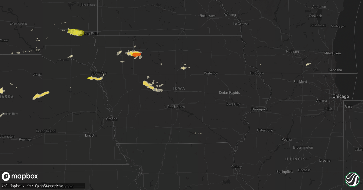
Hail Map in Iowa on September 19, 2018
Get this storm
September 19 map
$229
one time, instant access
Download today. No call, no setup
Keep the $229
Bought the map and want the full workflow? Apply the entire $229 to a subscription within 7 days. None of it is wasted.
Every map, not just this one
This buys you this map. Subscription and you get every map we run, in the markets you choose from a few cities to whole states to nationwide. Plus real-time alerts the moment a storm fires.
Contact data
Name, contact info, occupancy, even credit band for addresses in the footprint. You go from where it hit to who to call.
Become the source they trust
Unlimited branding weather history reports on demand. You already have the documented answer ready for the property owner, and you are the one who showed up with it.
Property data and RoofTrace estimates
Pull up any address you have got, its value and the exact code rules for that jurisdiction, straight from One Click Code. Then RoofTrace estimates the squares, pitch, and roof value, priced the way you price.
Storm reports in Iowa
Iowa
| Date | Description |
|---|---|
| 09/19/20183:49 AM CDT | At 848 PM CDT, a severe thunderstorm was located near Webb, or 13 miles southeast of Spencer In Clay County, moving east at 30 mph. HAZARD...Ping pong ball size hail. SOURCE...Radar indicated. IMPACT...People and animals outdoors will be injured. Expect damage to roofs, siding, windows, and vehicles. This severe thunderstorm will remain over mainly rural areas of northeastern Buena Vista and southeastern Clay Counties, including the following locations... Gillett Grove. |
| 09/19/20183:49 AM CDT | At 848 PM CDT, a severe thunderstorm was located near Silver Lake, or 13 miles southeast of Spencer In Clay County, moving east at 30 mph. HAZARD...60 mph wind gusts and quarter size hail. Rainfall to up to 3 inches per hour is possible as well. SOURCE...Radar indicated. IMPACT...Hail damage to vehicles is expected. Expect wind damage to roofs, siding, and trees. Locations impacted include... Emmetsburg, Five Island Lake, Silver Lake, Rush Lake, Lost Island Lake, West Bend, Ruthven, Mallard, Ayrshire, Cylinder, Plover, Curlew, Rodman, Kearney State Park, Lost Island Lake State Park and Emmetsburg Municipal Airport. |
| 09/18/20188:44 PM CDT | A local report indicates 1.75 inch wind near 3 W GILLETT GROVE |
All States Impacted by Hail Map on September 19, 2018
Cities Impacted by Hail Map on September 19, 2018
- Buna, TX
- Whitewater, WI
- Milton, WI
- Janesville, WI
- Johnstown, CO
- Loveland, CO
- Windsor, CO
- Greenville, IA
- Goodland, KS
- Spencer, IA
- Canistota, SD
- Ericson, NE
- Clearwater, NE
- Bartlett, NE
- Ewing, NE
- Elgin, NE
- Rockwell City, IA
- Saint Francis, KS
- Kanorado, KS
- Charlottesville, VA
- Barboursville, VA
- Keswick, VA
- Flagler, CO
- Lake City, IA
- Dickens, IA
- Webb, IA
- Max, NE
- McDonald, KS
- Scott, LA
- Primghar, IA
- Paullina, IA
- Salix, IA
- Emerson, NE
- Hubbard, NE
- Homer, NE
- Sergeant Bluff, IA
- Waterbury, NE
- Dakota City, NE
- Jasper, TX
- Jefferson, IA
- Purdum, NE
- Ainsworth, NE
- Brewster, NE
- Hartford, SD
- Humboldt, SD
- Monroe, SD
- Parker, SD
- Marion, SD
- Montrose, SD
- Farnhamville, IA
- Mittie, LA
- Pitkin, LA
- Oakdale, LA
- Akron, CO
- Kinder, LA
- Deer Trail, CO
- Moravia, IA
- Palisade, NE
- Henderson, TX
- Laneville, TX
- Woodrow, CO
- Mitchell, SD
- Platteville, WI
- Allen, NE
- Bridgewater, SD
- Glidden, IA
- Lohrville, IA
- Lanesboro, IA
- Ogden, IA
- Churdan, IA
- Scranton, IA
- Carroll, IA
- Grand Junction, IA
- Beaver, IA
- Jacksonville, FL
- Callahan, FL
- Dows, IA
- Bradford, IA
- Alden, IA
- Hampton, IA
- Iowa Falls, IA
- Royal, IA
- Sioux Rapids, IA
- Norfolk, NE
- Callaway, NE
- Plaucheville, LA
- Simmesport, LA
- Latimer, IA
- Bonesteel, SD
- Pilot Mound, IA
- Dayton, IA
- Spencer, SD
- Humboldt, IA
- Ayrshire, IA
- Gillett Grove, IA
- Linn Grove, IA
- Ruthven, IA
- Peterson, IA
- Saint Charles, SD
- Granville, IA
- Corsica, SD
- Cherokee, IA
- Meriden, IA
- Valentine, NE
- Lindon, CO
- Alexandria, SD
- Provencal, LA
- Cloutierville, LA
- Mora, LA
- Sutherland, IA
- Salem, SD
- Harrison, SD
- Emery, SD
- Bradenton, FL
- Yankton, SD
- Bassett, NE
- Geddes, SD
- Hayes Center, NE
- Yantis, TX
- Emory, TX
- Bird City, KS
- Kimball, SD
- Dallas, SD
- Gregory, SD
- Halsey, NE
- Troup, TX
- Lake Andes, SD
- Gothenburg, NE
- Unionville, IA
- Laurens, IA
- Marathon, IA
- Curlew, IA
- Everly, IA
- Crowley, LA
- Yuma, CO
- Otis, CO
- Bronson, IA
- Lawton, IA
- Mansfield, LA
- Rayne, LA
- Poteet, TX
- Benkelman, NE
- Stratton, NE
- Kit Carson, CO
- Deridder, LA
- Gowrie, IA
- Elton, LA
- Paton, IA
- Burwell, NE
- Ruckersville, VA
- Mission Hill, SD
- Salome, AZ
- Yulee, FL
- Delavan, WI
- Jeanerette, LA
- Kirbyville, TX
- Geneva, IA
- Logansport, LA
- Boxholm, IA
- Beckville, TX
- Mamou, LA
- Burke, SD
- Merna, NE
- Fairfax, SD
- Golden, CO
- Wheat Ridge, CO
- Denver, CO
- Chancellor, SD


