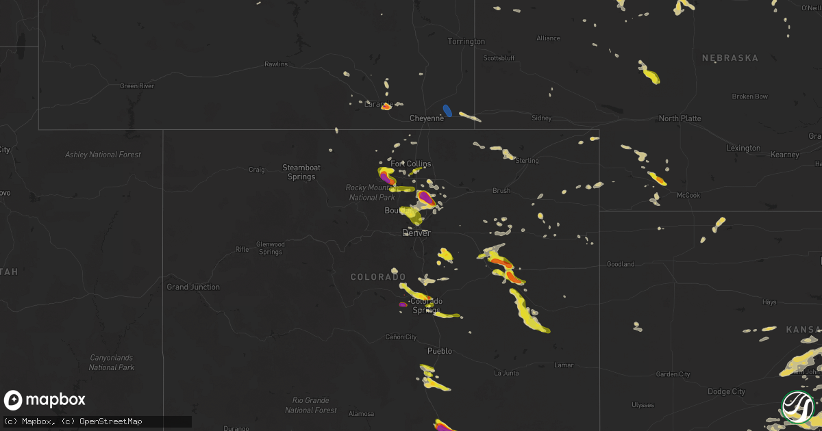
Hail Map on June 17, 2025
Get this storm
June 17 map
$229
one time, instant access
Download today. No call, no setup
Keep the $229
Bought the map and want the full workflow? Apply the entire $229 to a subscription within 7 days. None of it is wasted.
Every map, not just this one
This buys you this map. Subscription and you get every map we run, in the markets you choose from a few cities to whole states to nationwide. Plus real-time alerts the moment a storm fires.
Contact data
Name, contact info, occupancy, even credit band for addresses in the footprint. You go from where it hit to who to call.
Become the source they trust
Unlimited branding weather history reports on demand. You already have the documented answer ready for the property owner, and you are the one who showed up with it.
Property data and RoofTrace estimates
Pull up any address you have got, its value and the exact code rules for that jurisdiction, straight from One Click Code. Then RoofTrace estimates the squares, pitch, and roof value, priced the way you price.
States Impacted by Hail Map on June 17, 2025
Storm reports
South Carolina
| Date | Description |
|---|---|
| 06/17/20256:58 PM CDT | Social media report of a tree snapped in half in westminster. |
| 06/16/20258:54 PM CDT | Spotter estimated 50-60 mph winds near mineral springs road. Radar suggests a downburst in this area. |
| 06/16/20258:53 PM CDT | Sc dept of public safety reported a tree in the roadway along commerce blvd. Time estimated by radar. |
| 06/16/20258:33 PM CDT | Trees down in the cowpens area. |
| 06/16/20258:33 PM CDT | Trees down in the pacolet area. |
| 06/16/20258:30 PM CDT | Sc highway patrol reported trees down near augusta highway and golden jubilee road. |
| 06/16/20258:30 PM CDT | Sc highway patrol reported trees down near southland road and golden jubilee road. |
| 06/16/20258:30 PM CDT | Sc highway patrol reported trees down near i-26 in chapin. |
| 06/16/20258:26 PM CDT | Sc dept of public safety reported a tree down in the roadway along amicks ferry rd. Time estimated by radar. |
| 06/16/20258:23 PM CDT | Trees down in the pauline area. |
| 06/16/20258:23 PM CDT | Several trees and powerlines down in northeast spartanburg county. |
| 06/16/20258:23 PM CDT | Tree down on a house along lucerne drive. |
| 06/16/20258:22 PM CDT | Multiple trees and powerlines down around spartanburg. |
| 06/16/20258:17 PM CDT | Trees down on powerlines on the west side of spartanburg. |
| 06/16/20258:17 PM CDT | Tree down near lake bowen. |
| 06/16/20258:17 PM CDT | Frequent 50-60mph gusts observed. |
| 06/16/20258:17 PM CDT | Tree down across powerline in shannon forest. |
| 06/16/20258:16 PM CDT | Several trees down around the woodruff area... Some on powerlines. |
| 06/16/20258:16 PM CDT | Trees and powerlines down in roebuck. |
| 06/16/20258:13 PM CDT | Sc highway patrol reported trees down along highway 391 south of prosperity. |
| 06/16/20258:12 PM CDT | Spotter report with video. Estimated 50-60 mph winds near batesburg. |
| 06/16/20258:12 PM CDT | Tree down in inman. |
| 06/16/20258:07 PM CDT | Trees down in lyman. |
| 06/16/20258:07 PM CDT | Multiple trees and powerlines down. |
| 06/16/20258:07 PM CDT | Trees down on powerlines in the reidville area. |
| 06/16/20258:06 PM CDT | Tree down in landrum. |
| 06/16/20258:06 PM CDT | Tree down on powerline in campobello. |
| 06/16/20258:01 PM CDT | Several trees down around greer... A few of which fell on powerlines. |
| 06/16/20258:00 PM CDT | Trees and powerlines down in the harrison bridge rd area of simpsonville. |
| 06/16/20257:57 PM CDT | Trees and powerlines down in the i-85/pelham road area. |
| 06/16/20257:56 PM CDT | Trees down in taylors. |
| 06/16/20257:55 PM CDT | Trees and powerlines down in the five forks area. |
| 06/16/20257:52 PM CDT | Tree down partially blocking bridges road just west of holland road. |
| 06/16/20257:51 PM CDT | Picture of a snapped tree on the north side of greenville. |
| 06/16/20257:51 PM CDT | Trees and powerlines down in tigerville. |
| 06/16/20257:47 PM CDT | Powerlines down in mauldin. |
| 06/16/20257:47 PM CDT | Powerlines down in mauldin. |
| 06/16/20257:46 PM CDT | Trees and powerlines down in the slater-marietta area. |
| 06/16/20257:46 PM CDT | Trees and powerlines down in the travelers rest area. |
| 06/16/20257:43 PM CDT | Tree down on a house along notchwood court. |
| 06/16/20257:43 PM CDT | Trees and powerlines down in the moonville area. |
| 06/16/20257:41 PM CDT | Trees and powerlines down around powdersville. |
| 06/16/20257:37 PM CDT | Trees on powerlines in the piedmont area. |
| 06/16/20257:36 PM CDT | Trees and powerlines down in dacusville. |
| 06/16/20257:35 PM CDT | Several trees down in the easley area. |
| 06/16/20257:35 PM CDT | Trees down in pumpkintown. |
| 06/16/20257:30 PM CDT | Tree across the road at glassy mountain. |
| 06/16/20257:30 PM CDT | Social media report of trees and powerlines down in liberty. |
| 06/16/20257:26 PM CDT | Trees down near pickens high school. |
| 06/16/20257:25 PM CDT | Trained spotter estimated 60mph wind gusts along hwy 28 in anderson. |
| 06/16/20257:25 PM CDT | A couple trees down around iva. |
| 06/16/20257:25 PM CDT | Several trees reported down in the starr area. |
| 06/16/20257:20 PM CDT | Multiple trees down around central. |
| 06/16/20257:19 PM CDT | Social media report of trees and powerlines down in six mile. |
| 06/16/20257:15 PM CDT | Trees down around the pendleton area. |
| 06/16/20257:15 PM CDT | Trees down in the la france area. |
| 06/16/20257:09 PM CDT | Tree down on powerlines in tamassee. |
| 06/16/20257:04 PM CDT | Tree down across powerline in mountain rest. |
Kansas
| Date | Description |
|---|---|
| 06/17/20256:45 PM CDT | A local report indicates 1.50 inch wind near Geuda Springs |
| 06/17/20256:15 PM CDT | A local report indicates 60 MPH wind near Leon |
| 06/17/20256:13 PM CDT | A local report indicates 60 MPH wind near Leon |
| 06/17/20256:13 PM CDT | 10 inch diameter tree uprooted. |
| 06/17/20256:10 PM CDT | A local report indicates 1.75 inch wind near 3 E Wellington |
| 06/17/20255:57 PM CDT | A local report indicates 1.75 inch wind near Augusta |
| 06/17/20255:52 PM CDT | A local report indicates 1.00 inch wind near 1 NW Augusta |
| 06/17/20255:52 PM CDT | Power pole snapped and leaning onto a house. |
| 06/17/20255:51 PM CDT | A local report indicates 1.00 inch wind near 1 NW Augusta |
| 06/17/20255:42 PM CDT | A local report indicates 64 MPH wind near 4 SSE Benton |
| 06/17/20255:38 PM CDT | 2 foot diameter trees down. |
| 06/17/20255:35 PM CDT | Estimated 80 mph winds along with nickel sized hail. |
| 06/17/20255:35 PM CDT | Awos station k3au augusta municipal airport. |
| 06/17/20255:34 PM CDT | A local report indicates 2.75 inch wind near 5 SE Conway Springs |
| 06/17/20255:30 PM CDT | Asos station kict wichita eisenhower airport. |
| 06/17/20255:30 PM CDT | Power lines down. |
| 06/17/20255:22 PM CDT | A local report indicates 1.75 inch wind near 4 SSW Conway Springs |
| 06/17/20255:19 PM CDT | A local report indicates 1.00 inch wind near 3 W Andover |
| 06/17/20255:16 PM CDT | A local report indicates 61 MPH wind near Mcconnell Air Force Bas |
| 06/17/20255:13 PM CDT | 60 to 70 mph wind estimate at pawnee and oliver. |
| 06/17/20255:10 PM CDT | A local report indicates 1.25 inch wind near 2 NNW East Wichita |
| 06/17/20255:09 PM CDT | A local report indicates 60 MPH wind near 3 SSE Bel Aire |
| 06/17/20255:08 PM CDT | Several powerlines down throughout the metro. |
| 06/17/20255:06 PM CDT | Six inch diameter branches down. |
| 06/17/20255:01 PM CDT | Overturned semi truck based on view from highway camera. |
| 06/17/20254:59 PM CDT | A local report indicates 1.25 inch wind near Park City |
| 06/17/20254:49 PM CDT | A local report indicates 75 MPH wind near 4 S Maize |
| 06/17/20254:47 PM CDT | Tree limbs down with the 60 mph winds. |
| 06/17/20254:42 PM CDT | Estim |
| 06/17/20254:42 PM CDT | Estimated 60 to 70 mph winds near 34th n & ridge rd. |
| 06/17/20254:41 PM CDT | A local report indicates 62 MPH wind near 2 ESE Maize |
| 06/17/20254:41 PM CDT | A local report indicates a tornado near 1 SSW Harper |
| 06/17/20254:28 PM CDT | A local report indicates 60 MPH wind near Colwich |
| 06/17/20254:26 PM CDT | Law enforcement estimated 70 mph winds and nickel sized hail. |
| 06/17/20254:17 PM CDT | A local report indicates 1.25 inch wind near Mount Hope |
| 06/17/20252:39 PM CDT | A local report indicates 1.00 inch wind near 3 E Sterling |
| 06/17/20252:22 PM CDT | Kake relayed viewer report of quarter sized hail. Time is estimated from radar. |
| 06/17/20257:47 AM CDT | A local report indicates 60 MPH wind near 4 N Clearwater |
| 06/17/20257:40 AM CDT | A local report indicates 60 MPH wind near 4 N Clearwater |
| 06/17/202512:42 AM CDT | A local report indicates 70 MPH wind near Tyro |
| 06/16/202510:59 PM CDT | Asos station kwld strother field airport. |
| 06/16/202510:54 PM CDT | A local report indicates 71 MPH wind near Winfield |
| 06/16/20259:48 PM CDT | A local report indicates 62 MPH wind near 5 SW Conway Springs |
| 06/16/20259:24 PM CDT | A local report indicates 58 MPH wind near 2 N Derby |
| 06/16/20259:20 PM CDT | A local report indicates 59 MPH wind near 3 SE Haysville |
| 06/16/20259:12 PM CDT | A local report indicates 1.00 inch wind near 2 SW Downtown Wichita |
| 06/16/20259:12 PM CDT | Ks storm info estimates 60 to 65 mph and pea to dime sized hail. |
| 06/16/20259:06 PM CDT | Combined with dime sized hail. |
| 06/16/20258:54 PM CDT | Estimates 65 to 70 mph winds. |
| 06/16/20258:54 PM CDT | Estimates 65 to 70 mph winds. |
| 06/16/20258:47 PM CDT | A local report indicates 1.75 inch wind near Goddard |
| 06/16/20258:32 PM CDT | A local report indicates 1.25 inch wind near Garden Plain |
| 06/16/20257:23 PM CDT | A local report indicates 60 MPH wind near 3 W Winfield |
| 06/16/20257:13 PM CDT | A local report indicates 2.00 inch wind near Arkansas City |
| 06/16/20257:07 PM CDT | A local report indicates 3.81 inch wind near Arkansas City |
| 06/16/20257:07 PM CDT | A local report indicates 2.75 inch wind near Arkansas City |
| 06/16/20257:06 PM CDT | A local report indicates 1.75 inch wind near Arkansas City |
| 06/16/20257:03 PM CDT | A local report indicates 1.00 inch wind near Arkansas City |
Maryland
| Date | Description |
|---|---|
| 06/17/20251:33 AM CDT | One tree down due to thunderstorm winds at the intersection of liberty road and wards chapel road in randallstown. |
| 06/17/20251:33 AM CDT | One tree down due to thunderstorm winds at the intersection of liberty road and wards ch |
| 06/17/20251:33 AM CDT | One tree down due to thunderstorm |
| 06/17/20251:33 AM CDT | One tree down due to thunderstorm winds at the intersection of liberty road and wards cha |
| 06/17/20251:33 AM CDT | One tree down due t |
| 06/16/20259:14 PM CDT | Corrects previous tstm wnd dmg report from 2 nne myersville. One tree down due to thunderstorm winds along harp hill road. |
Kentucky
| Date | Description |
|---|---|
| 06/17/20256:13 PM CDT | Delayed report. Tree down on route 229 around 4 miles south of the intersection between ky-1189 and ky-229 and in the vicinity of camp ground school. Time estimated via |
| 06/17/20254:40 PM CDT | Tree reported on a truck along with powerlines. Time of report - probably from an earlier storm. |
| 06/17/20253:59 PM CDT | Social media report of a large tree down near the mouth of johnson fork in the hazel green area of wolfe county. Time estimated via radar. |
| 06/17/20252:47 PM CDT | Corrects previous tstm wnd dmg report from 2 ne hooker. Tree reported on a truck along with powerlines in the vicinity of 712 ephram creek rd. Time estimated from radar |
| 06/17/20252:30 PM CDT | Tree down at intersection of mill and 5th streets. Time estimated off of radar. |
| 06/17/20252:05 PM CDT | Delayed report of a downed tree at mile marker 34 on ky-80. Time provided by 911 call center and corroborated with radar imagery. |
| 06/16/202510:00 PM CDT | Tree down on a vehicle and utility lines. Could have been from an earlier storm. |
Colorado
| Date | Description |
|---|---|
| 06/17/20256:01 PM CDT | Recored by the lazy_td_farm_ |
| 06/17/20255:46 PM CDT | High_plains_coat_ |
| 06/17/20255:32 PM CDT | Delayed report with estimated time. Used radar to line it up with where the hail core was. |
| 06/17/20255:30 PM CDT | Report from mping: hen egg |
| 06/17/20255:29 PM CDT | Report from mping: half dollar |
| 06/17/20254:12 PM CDT | A local report indicates 1.50 inch wind near 8 SE Colorado City |
| 06/17/20254:08 PM CDT | A local report indicates 1.00 inch wind near 8 SE Colorado City |
| 06/17/20253:35 PM CDT | A local report indicates 1.00 inch wind near 7 E Colorado City |
| 06/17/20253:11 PM CDT | Report from mping: quarter |
| 06/17/20253:10 PM CDT | Report from mping: quarter |
| 06/17/20253:10 PM CDT | A local report indicates 1.00 inch wind near 3 NW Northglenn |
| 06/17/20253:08 PM CDT | Delayed report. |
| 06/17/20253:06 PM CDT | 8-10 inch diameter tree downed. |
| 06/17/20252:57 PM CDT | Report from mping: quarter |
| 06/17/20252:57 PM CDT | Report from mping: quarter |
| 06/17/20252:57 PM CDT | Report from mping: quarter |
| 06/17/20252:54 PM CDT | Report from mping: half dollar |
| 06/17/20252:54 PM CDT | Report from mping: quarter |
| 06/17/20252:52 PM CDT | A local report indicates 1.00 inch wind near 2 ESE Timnath |
| 06/17/20252:48 PM CDT | A local report indicates 1.00 inch wind near 2 WNW Lafayette |
| 06/17/20252:46 PM CDT | Report from mping: golf ball |
| 06/17/20252:45 PM CDT | Report from mping: golf ball |
| 06/17/20252:34 PM CDT | Report from mping: quarter |
| 06/17/20252:29 PM CDT | A local report indicates 1.50 inch wind near 7 SSW Black Forest |
| 06/17/20252:28 PM CDT | Report from mping: half dollar |
| 06/17/20252:28 PM CDT | A local report indicates 1.50 inch wind near 5 N Colorado Springs |
| 06/17/20252:26 PM CDT | Report from mping: quarter |
| 06/17/20252:26 PM CDT | A local report indicates 1.00 inch wind near 5 NE Manitou Springs |
| 06/17/20252:25 PM CDT | A local report indicates 1.00 inch wind near 5 NE Manitou Springs |
| 06/17/20252:23 PM CDT | Report from mping: quarter |
| 06/17/20252:21 PM CDT | A local report indicates 1.00 inch wind near 5 SSE Air Force Academy |
| 06/17/20252:20 PM CDT | A local report indicates 1.00 inch wind near 5 SSE Air Force Academy |
| 06/17/20252:19 PM CDT | A local report indicates 1.00 inch wind near 5 NE Manitou Springs |
| 06/17/20252:11 PM CDT | Mping report. |
| 06/17/20252:11 PM CDT | Report from mping: quarter |
| 06/17/20251:41 PM CDT | Confirmed tornado northeast of divide... In teller county. Rating was ef-1 with winds estimated at 106 mph. |
| 06/17/20251:40 PM CDT | Relayed ham radio reports of trees down and power lines down near teller county county road 511... And hwy 51. |
| 06/17/20251:15 PM CDT | Report from mping: ping pong ball |
| 06/17/202512:16 PM CDT | A local report indicates 1.00 inch wind near 7 N Limon |
| 06/17/202511:57 AM CDT | A local report indicates 1.00 inch wind near 3 ENE Colorado Springs |
| 06/17/202511:56 AM CDT | Report from mping: quarter |
| 06/17/202511:10 AM CDT | A local report indicates 1.00 inch wind near 1 SSE Agate |
| 06/17/20257:18 AM CDT | Report from mping: ping pong ball |
| 06/17/20257:07 AM CDT | Report from mping: quarter |
Mississippi
| Date | Description |
|---|---|
| 06/17/20256:04 PM CDT | Local law enforcement reported multiple trees and powerlines down across northeastern portions of lincoln county. |
| 06/17/20255:12 PM CDT | Law enforcement reported a tree down on lily rd. |
Indiana
| Date | Description |
|---|---|
| 06/17/20256:48 AM CDT | Large tree limb down |
| 06/16/20258:10 PM CDT | Report of a large ash tree down on quail valley drive. Time estimated from radar. |
Nebraska
| Date | Description |
|---|---|
| 06/17/20256:49 PM CDT | A local report indicates 1.50 inch wind near 7 E Hamlet |
| 06/17/20256:40 PM CDT | Investigation is needed on whether it is a landspout or tornado. |
| 06/17/20256:36 PM CDT | Imperial asos. |
| 06/17/20256:29 PM CDT | Recorded at mesonet station near benkelman. Id: home_ |
| 06/17/20253:20 PM CDT | Brief tornado touched down in a field... Verified by photos and timing estimated with radar. Damage to a center pivot irrigation system. |
Georgia
| Date | Description |
|---|---|
| 06/17/20256:54 PM CDT | Trees down in lavonia. |
| 06/17/20256:46 PM CDT | Tree and large limbs down along cliffs ridge rd. |
| 06/17/20256:43 PM CDT | Trees down in carnesville. |
| 06/17/20256:20 PM CDT | Tree down across 115 e in cleveland ga. |
| 06/17/20256:20 PM CDT | Tree down across |
| 06/17/20256:08 PM CDT | Tree down along the 4100 block of railroad street. |
| 06/17/20256:06 PM CDT | Tree down along south enota drive ne near the intersection with park hill drive. |
| 06/17/20256:04 PM CDT | Tree down along honeysuckle road near highway 129. |
| 06/17/20256:02 PM CDT | Tree down in alberta banks park. |
| 06/17/20255:59 PM CDT | Tree and wires down near the intersection of chestatee road and osceola trail. |
| 06/17/20255:59 PM CDT | Tree down along locklin road near the intersection with pope road. |
| 06/17/20255:58 PM CDT | Tree down near the intersection of ben parks road and jake kemp road. |
| 06/17/20255:58 PM CDT | Tree and wires down near the intersection of hopewell church road and letha road. |
| 06/17/20255:56 PM CDT | Tree down near the intersection of highway 81 and mystic drive. |
| 06/17/20255:55 PM CDT | Tree down along pine trail near twin creek drive. |
| 06/17/20255:55 PM CDT | Tree down on cool springs road near the intersection with chestatee road. |
| 06/17/20255:50 PM CDT | Tree down on a home near the intersection of testatee gap valley rd and bell shadows dr. |
| 06/17/20255:45 PM CDT | Tree down on building near the intersection of doe court and taylor road. |
| 06/17/20255:45 PM CDT | Trees down at the end of tolhurst rd. |
| 06/17/20255:38 PM CDT | Tree down on building near the intersection of howard way and luther way. |
| 06/17/20255:35 PM CDT | Tree reported down in the parking lot of an apartment complex on cedar run. |
| 06/17/20255:34 PM CDT | Tree down near the intersection of roswell road and northridge crossing. |
| 06/17/20255:33 PM CDT | Tree down along hopewell chase drive near the intersection with chastain court. |
| 06/17/20255:25 PM CDT | Trees down along woodall road. |
| 06/17/20255:22 PM CDT | Trees and wires down near the intersection of jones avenue and south main street. |
| 06/17/20255:19 PM CDT | Tree down on structure along the 200 block of bethany manor court. |
| 06/17/20255:12 PM CDT | Tree down on structure near the intersection of sureyya drive and sautee place. |
| 06/17/20255:03 PM CDT | Tree down along interstate 20 east near fulton industrial boulevard. |
| 06/17/20255:03 PM CDT | Tree down on structure near the intersection of jackie moore circle and nowlin circle. |
| 06/17/20254:47 PM CDT | Tree down near the intersection of green loop road nw and highway 140. |
| 06/17/20254:44 PM CDT | Multiple trees down near the intersection of boatner avenue and ridgeview drive. |
| 06/17/20254:40 PM CDT | Tree and wires down near the intersection of yeager road and carroll drive. |
| 06/17/20254:20 PM CDT | Tree down along cut log road near pine pitch road. |
| 06/17/20254:20 PM CDT | Tree reported down on a house near the intersection of cooper rd and steward rd. |
| 06/17/20254:15 PM CDT | Powerlines down on the 200th block of lowery road near rockmart. |
| 06/17/20254:12 PM CDT | Tree down on a vehicle near the intersection of lees chapel road and lovvorn road. |
| 06/17/20254:04 PM CDT | A few trees down along brewster field road and garmon road. |
Texas
| Date | Description |
|---|---|
| 06/17/20256:38 PM CDT | Time estimated from radar. |
| 06/16/20258:14 PM CDT | Measured by ttu mesonet. |
| 06/16/20258:00 PM CDT | Report from mping: quarter |
| 06/16/20257:59 PM CDT | Report from mping: quarter |
| 06/16/20257:58 PM CDT | Report from mping: quarter |
| 06/16/20257:53 PM CDT | Report from mping: golf ball |
| 06/16/20257:41 PM CDT | Report from mping: quarter |
| 06/16/20257:38 PM CDT | A local report indicates 1.75 inch wind near Woodrow |
| 06/16/20257:35 PM CDT | A local report indicates 1.75 inch wind near 3 WNW Woodrow |
| 06/16/20257:35 PM CDT | Photo shows several hailstones about 2 inches in diameter in the area of slide rd and fm-41. Time estimated from radar. |
| 06/16/20257:33 PM CDT | Backyard playground equipment lifted and blown a few dozen yards... Impacting and damaging a fence. Time estimated from radar. |
| 06/16/20257:33 PM CDT | Sliding glass doors blown in at the front of the academy sports store on quaker ave. Time estimated from radar. |
| 06/16/20257:33 PM CDT | Time estimated from radar. |
| 06/16/20257:25 PM CDT | A local report indicates 1.00 inch wind near 9 SW Darrouzett |
| 06/16/20257:25 PM CDT | A local report indicates 1.75 inch wind near 5 S Wolfforth |
| 06/16/20257:19 PM CDT | Measured by the ttu mesonet. |
| 06/16/20257:14 PM CDT | A local report indicates 1.00 inch wind near 5 E Wolfforth |
| 06/16/20257:10 PM CDT | Report from mping: half dollar |
| 06/16/20257:01 PM CDT | A local report indicates 1.00 inch wind near 9 SE Floydada |
| 06/16/20257:01 PM CDT | Corrects previous hail report from floydada. |
North Carolina
| Date | Description |
|---|---|
| 06/16/20258:59 PM CDT | Several trees and large limbs down in the casar... Belwood and fallston areas of northern cleveland county. |
| 06/16/20258:43 PM CDT | Trees and powerlines down on the west side of shelby. |
| 06/16/20258:38 PM CDT | Trees and powerlines downed around ellenboro. |
| 06/16/20258:34 PM CDT | Trees down in forest city. |
| 06/16/20258:27 PM CDT | Trees and powerlines down around the rutherfordton area. |
| 06/16/20258:18 PM CDT | Social media picture of several trees down in mill spring. |
| 06/16/20258:07 PM CDT | Trees down on utility equipment. |
| 06/16/20258:06 PM CDT | Several trees down in the tryon area. |
| 06/16/20258:02 PM CDT | Trees down on utility equipment. |
| 06/16/20257:42 PM CDT | Trees down on utility equipment. |
Arkansas
| Date | Description |
|---|---|
| 06/17/20256:55 AM CDT | Report from mping: quarter |
| 06/17/20256:26 AM CDT | Report from mping: quarter |
| 06/17/20251:38 AM CDT | Large tree knocked down by thunderstorm winds. Report relayed by broadcast media. |
| 06/17/20251:38 AM CDT | Large tree knocked down by thunderstor |
| 06/17/20251:38 AM CDT | Large tree knocked down by thunderstorm winds. Report relayed by broadcast media |
| 06/17/20251:38 AM CDT | La |
| 06/17/20251:38 AM CDT | Large tree knocked down by thunderstorm winds. Report relayed by broadcast media. |
| 06/17/20251:30 AM CDT | Emergency manager reports 3 homes with significant damage. Several other homes with minor damage. |
| 06/17/20251:30 AM CDT | Emergency manager reports 3 homes with significant damage. Several other homes with minor damage. Several chicken houses also damaged. Damage area is just to the north- |
| 06/17/20251:30 AM CDT | Emergency manager reports 3 homes with significant damage. Several other homes with minor damage. Several chicken houses also damaged. Damage area i |
Wyoming
| Date | Description |
|---|---|
| 06/17/20255:12 PM CDT | Mesonet station wy22 2.7 nw arlington |
| 06/17/20255:00 PM CDT | A local report indicates 1.00 inch wind near 18 SE Wright |
| 06/17/20254:55 PM CDT | A local report indicates 1.00 inch wind near 18 SE Wright |
| 06/17/20254:42 PM CDT | Mesonet station wy18 halleck ridge |
| 06/17/20254:38 PM CDT | Mesonet station kskl skyline |
| 06/17/20253:50 PM CDT | Numerous spotter reports of funnels and occasional touchdowns between 2:40pm and 3:00pm. Touchdown was not confirmed. Time and location are based on a more detailed pub |
| 06/17/20253:50 PM CDT | Numerous spotter reports of funnels and occasional touchdowns between 2:40pm and 3:00pm. Touchdown was no |
| 06/17/20253:35 PM CDT | Multiple reports of funnel clouds and brief tornado near manville. Verified with pictures... With location and time estimated by radar. Rated ef-u in coordination with |
| 06/17/20252:57 PM CDT | Mesonet station up015 5.7 w burns |
| 06/17/20252:40 PM CDT | Pea sized hail... Very heavy rainfall... And estimated 60 mph winds. |
| 06/17/20251:25 PM CDT | Multiple spotters reported a tornado. Exact location and time estimated from radar. |
| 06/17/20251:15 PM CDT | Photos of hail next to measuring tape. Location estimated based on radar. |
| 06/17/20251:13 PM CDT | Accumulating quarter sized hail on the east side of laramie. Report received via facebook. |
West Virginia
| Date | Description |
|---|---|
| 06/17/20259:14 AM CDT | One tree down due to thunderstorm winds along millvale/bloomery road. |
| 06/16/20259:14 PM CDT | Corrects previous tstm wnd dmg report from 2 nne millville. One tree down due to thunderstorm winds along millvale/bloomery road. |
Virginia
| Date | Description |
|---|---|
| 06/16/202510:45 PM CDT | Large tree down blocking road near intersection of beaver creek and possum hollow road. |
| 06/16/20259:00 PM CDT | Tree reported down. Time estimated from radar. |
Michigan
| Date | Description |
|---|---|
| 06/16/20257:30 PM CDT | Tree down onto a house. Time estimated from radar. |
Tennessee
| Date | Description |
|---|---|
| 06/16/20258:27 PM CDT | Trees downed. |
| 06/16/20258:15 PM CDT | 3 trees down in church hill area. Time estimated from radar. |
| 06/16/20258:12 PM CDT | Social media picture of a 1-3 inch diameter tree branch laying on ground after severe thunderstorm passage near mountain view road close to church hill tn. |
| 06/16/20258:08 PM CDT | Hail from penny to quarter sized fell approximately for 1 minute. Chipped the windshield of a car in a couple of places. At time of report |
South Dakota
| Date | Description |
|---|---|
| 06/17/20253:52 PM CDT | A local report indicates 1.25 inch wind near 3 NW Hot Springs |
| 06/17/20253:10 PM CDT | Report from mping: half dollar |
| 06/17/20253:07 PM CDT | Report from mping: quarter |
| 06/17/20252:32 PM CDT | A lot of pea sized hail... Also. |
North Dakota
| Date | Description |
|---|---|
| 06/17/20252:38 PM CDT | Report of a skinny rope funnel 3 quarters of the way down with a dust whirl in the field underneath. Picture also relayed via broadcast media. Ground circulation was br |
Alabama
| Date | Description |
|---|---|
| 06/17/20256:49 PM CDT | A tree was knocked down at 561 mill creek loop. Time estimated by radar. |
| 06/17/20256:49 PM CDT | A tree was knocked down at 561 mill creek loop. Time estimated by radar. |
| 06/17/20256:45 PM CDT | Corrects previous tstm wnd dmg report from 1 se cherokee. A tree was knocked down at 19 u.s. Highway 72. Time estimated by radar. |
| 06/17/20256:34 PM CDT | Corrects previous tstm wnd dmg report from 4 wnw cherokee. A tree was knocked down at 561 mill creek loop. Time estimated by radar. |
| 06/17/20255:45 PM CDT | Corrects previous tstm wnd dmg report from 3 ssw leighton. A power pole was knocked down at 2780 highway 157. Time estimated by radar. |
| 06/17/20255:45 PM CDT | A tree was knocked down blocking the entire roadway at the intersection of townsell lane and cr 83. Time estimated by radar. |
| 06/17/20255:19 PM CDT | Corrects previous tstm wnd dmg report from 9 nw russellville. A tree was knocked down at 4525 jones road. Time estimated by radar. |
| 06/17/20255:18 PM CDT | Corrects previous tstm wnd dmg report from 6 w lexington. A tree was knocked down blocking both lanes at the intersection of cr 33 and cr 39. Time estimated by radar. |
| 06/17/20254:54 PM CDT | A tree was knocked down onto cr 25 at cr 170 blocking the northbound lane. Time estimated by radar. |
| 06/17/20254:48 PM CDT | Corrects previous tstm wnd dmg report from 3 ene saint florian. A tree was knocked down just past mt. Zion church near the intersection of cr 27 and cr 122 blocking 3 q |
| 06/17/20254:48 PM CDT | Corrects previous tstm wnd dmg report from 3 e saint florian. A tree was knocked down at the intersection of cr 27 and cr 30. Another tree was leaning over the road. Ti |
| 06/17/20254:43 PM CDT | Corrects previous tstm wnd dmg report from 5 e waterloo. A tree was knocked down blocking the entire roadway at the intersection of townsell lane and cr 83. Time estima |
| 06/17/20254:43 PM CDT | Corrects previous tstm wnd dmg report from 5 e waterloo. A tree was knocked down blocking the entire roadway at the intersection of townsell l |
| 06/17/20254:10 PM CDT | Corrects previous tstm wnd dmg report from 3 n killen. A tree was knocked down onto cr 25 at cr 170 blocking the northbound lane. Time estimated by radar. |
| 06/17/20253:52 PM CDT | A couple trees down in the fruithurst area. |
| 06/17/20253:40 PM CDT | A couple trees down in the heflin area. |
| 06/17/20253:20 PM CDT | Numerous trees down across anniston... Including quintard ave... Rainbow cir... Conger rd... M st... And interstate 20. |
| 06/17/20253:04 PM CDT | A couple trees down in perry county... Including along highway 219. |
| 06/17/20252:55 PM CDT | Several trees down around talladega county... Mainly in and around the city of talladega. |
| 06/17/20252:18 PM CDT | Tree uprooted onto powerline. Time estimated based on radar. |
| 06/16/20257:54 PM CDT | A tree was knocked down at 19 u.s. Highway 72. Time estimated by radar. |
| 06/16/20257:32 PM CDT | A power pole was knocked down at 2780 highway 157. Time estimated by radar. |
| 06/16/20257:28 PM CDT | A tree was knocked down at 4525 jones road. Time estimated by radar. |
| 06/16/20257:12 PM CDT | A tree was knocked down blocking both lanes at the intersection of cr 33 and cr 39. Time estimated by radar. |
| 06/16/20257:10 PM CDT | A tree was knocked down just past mt. Zion church near the intersection of cr 27 and cr 122 blocking 3 quarters of the roadway. Time estimated by radar. |
| 06/16/20257:10 PM CDT | A tree was knocked down at the intersection of cr 27 and cr 30. Another tree was leaning over the road. Time estimated by radar. |
Oklahoma
| Date | Description |
|---|---|
| 06/17/20256:32 PM CDT | Hail up to ping pong ball size fell. |
| 06/17/20255:37 PM CDT | Ping pong ball size hail fell. Report via social media. |
| 06/17/20251:25 AM CDT | A local report indicates 62 MPH wind near 5 WNW Westville |
| 06/17/20251:25 AM CDT | Tree down on hwy 10 and cnty road 652 blocking one lane. |
| 06/17/20251:14 AM CDT | Social media report indicating damage to several green houses caused by thunderstorm winds. |
| 06/17/20251:00 AM CDT | Tornado debris signature detected. |
| 06/17/202512:55 AM CDT | Tree on house at 96th and newton place. |
| 06/17/202512:48 AM CDT | Tornado debris signature detected. |
| 06/17/202512:47 AM CDT | A local report indicates 60 MPH wind near 4 WSW Oologah |
| 06/17/202512:45 AM CDT | A local report indicates 72 MPH wind near 4 NW Talala |
| 06/17/202512:40 AM CDT | A local report indicates 64 MPH wind near 2 ENE Copan |
| 06/17/202512:37 AM CDT | Ef1 with damaged homes... Destroyed outbuildings... And damage numerous trees. |
| 06/17/202512:34 AM CDT | A local report indicates 60 MPH wind near 2 ENE Copan |
| 06/17/202512:31 AM CDT | Transformers being blown. Estimated 70mph. |
| 06/17/202512:10 AM CDT | A local report indicates 69 MPH wind near 2 S Wynona |
| 06/17/202512:08 AM CDT | Large tree branch broken off main trunk and fell on vehicle. Additional tree damage in neighborhood. |
| 06/17/202512:07 AM CDT | Thunderstorm wind gust measured at 62 mph. Multiple tree branches broken and blown down at apartment complex. |
| 06/17/202512:06 AM CDT | Wooden pergola blown off back porch. Damage occurred near intersection of south cypress place and west jackson street. |
| 06/17/202512:05 AM CDT | 6 inch limbs down 51st and yale. |
| 06/17/202512:00 AM CDT | A local report indicates 64 MPH wind near 8 ESE Foraker |
| 06/16/202511:58 PM CDT | Damage to promenade mall. |
| 06/16/202511:55 PM CDT | A local report indicates 62 MPH wind near 2 S Wynona |
| 06/16/202511:50 PM CDT | Multiple trees and tree limbs broken or damaged vicinity of eagle view rv park... East of the keystone dam and just south of highway 412. Time estimated by radar. |
| 06/16/202511:45 PM CDT | Numerous 10-12 inch thick limbs down. |
| 06/16/202510:05 PM CDT | A local report indicates 65 MPH wind near 3 SE Delaware |
| 06/16/20259:55 PM CDT | A local report indicates 71 MPH wind near 1 NNW Watonga |
| 06/16/20259:45 PM CDT | A local report indicates 65 MPH wind near Watonga 7W |
| 06/16/20259:40 PM CDT | Personal weather station. |
| 06/16/20259:27 PM CDT | A local report indicates 1.75 inch wind near 1 W Copan |
| 06/16/20259:20 PM CDT | A local report indicates 65 MPH wind near 4 N Putnam |
| 06/16/20259:20 PM CDT | A local report indicates 60 MPH wind near 10 S Bartlesville |
| 06/16/20259:14 PM CDT | A local report indicates 1.25 inch wind near 5 ENE Optima |
| 06/16/20259:05 PM CDT | Report from mping: ping pong ball |
| 06/16/20258:55 PM CDT | A local report indicates 63 MPH wind near 5 NW Camargo |
| 06/16/20258:53 PM CDT | Roof damage and power out. |
| 06/16/20258:47 PM CDT | Corrects previous tstm wnd gst report from foraker. |
| 06/16/20258:40 PM CDT | Report from mping: quarter |
| 06/16/20258:37 PM CDT | A local report indicates 1.25 inch wind near 8 SW Arnett |
| 06/16/20258:37 PM CDT | Half dollar sized hail reported by a trained spotter. |
| 06/16/20258:34 PM CDT | A local report indicates 63 MPH wind near 8 ESE Foraker |
| 06/16/20258:10 PM CDT | A local report indicates 65 MPH wind near 8 WSW Arnett |
| 06/16/20257:47 PM CDT | Quarter to ping pong ball sized hail noted on dot cameras. |
Pennsylvania
| Date | Description |
|---|---|
| 06/17/20254:11 PM CDT | Numerous trees down on wires off of york road. |
New Mexico
| Date | Description |
|---|---|
| 06/16/20259:00 PM CDT | Photo from public of golf ball size hail near philmont scout ranch. |
Cities Impacted by Hail Map on June 17, 2025
- Idalia, CO
- Cope, CO
- Akron, CO
- Yuma, CO
- Fort Collins, CO
- Nunn, CO
- Wellington, CO
- Pawnee, OK
- Cushing, OK
- Ripley, OK
- Stillwater, OK
- Glencoe, OK
- Yale, OK
- Maramec, OK
- Elizabeth, CO
- Parker, CO
- Otis, CO
- Byers, CO
- Wray, CO
- Kiowa, CO
- Woodrow, CO
- Jennings, OK
- Cleveland, OK
- Drumright, OK
- Hominy, OK
- Osage, OK
- Terlton, OK
- Fort Morgan, CO
- Haigler, NE
- Mannford, OK
- Marion, LA
- Murdock, KS
- Cheney, KS
- Deer Trail, CO
- Kingman, KS
- Lindon, CO
- Anton, CO
- Bristow, OK
- Garden Plain, KS
- Viola, KS
- Goddard, KS
- Conway Springs, KS
- Clearwater, KS
- Milton, KS
- Wellington, KS
- Peck, KS
- Belle Plaine, KS
- Haysville, KS
- Wichita, KS
- Derby, KS
- Udall, KS
- Mulvane, KS
- Oxford, KS
- Winfield, KS
- Bastrop, LA
- Pretty Prairie, KS
- Broken Arrow, OK
- Haskell, OK
- Haven, KS
- Mount Hope, KS
- Andale, KS
- Colwich, KS
- Saint Francis, KS
- Mcpherson, KS
- Agate, CO
- Windom, KS
- Galva, KS
- Cedar Vale, KS
- Limon, CO
- Laramie, WY
- Walden, CO
- Genoa, CO
- Lyons, KS
- Chase, KS
- Colorado Springs, CO
- Delaware, OK
- Little River, KS
- Nowata, OK
- Peabody, KS
- Marion, KS
- Hamilton, KS
- Cassoday, KS
- Eureka, KS
- Bazine, KS
- Sedalia, CO
- La Crosse, KS
- Burns, KS
- Florence, KS
- Alexander, KS
- Drake, CO
- Glen Haven, CO
- Virgil, KS
- El Dorado, KS
- Raymond, KS
- Jayess, MS
- Hugo, CO
- Bosler, WY
- Ellinwood, KS
- Hudson, KS
- Bison, KS
- Nekoma, KS
- Rush Center, KS
- Estes Park, CO
- Paris, AR
- Magazine, AR
- Woodland Park, CO
- Divide, CO
- Larned, KS
- St John, KS
- Monument, CO
- Larkspur, CO
- Cedar Point, KS
- Franktown, CO
- Mount Ida, AR
- Hillsboro, KS
- Arriba, CO
- Livermore, CO
- Belpre, KS
- Fountain, CO
- Mena, AR
- Royal, AR
- Lisman, AL
- Laurel, MS
- Cottonwood Falls, KS
- Bellvue, CO
- York, AL
- Ward, AL
- Garfield, KS
- Elbert, CO
- Loveland, CO
- West Point, NE
- Lyons, CO
- Hot Springs National Park, AR
- Hill City, SD
- Macksville, KS
- Matfield Green, KS
- Green Mountain Falls, CO
- Waldron, AR
- Canton, KS
- Alden, KS
- Elk Point, SD
- Manitou Springs, CO
- Peyton, CO
- Carr, CO
- Usaf Academy, CO
- Harvey, AR
- Chatsworth, IA
- Hawarden, IA
- Akron, IA
- Sterling, KS
- Berthoud, CO
- Long Pine, NE
- Geddes, SD
- Newport, NE
- Stuart, NE
- Inman, KS
- Lehigh, KS
- Olpe, KS
- Longmont, CO
- Nickerson, KS
- Hutchinson, KS
- Lead, SD
- Pavillion, WY
- Danville, AR
- Deadwood, SD
- Boulder, CO
- Salemburg, NC
- Roseboro, NC
- Autryville, NC
- Rapid City, SD
- Yoder, CO
- Cascade, CO
- Niwot, CO
- Louisville, CO
- Lafayette, CO
- Broomfield, CO
- Erie, CO
- Timnath, CO
- Windsor, CO
- Plainview, AR
- Sylvia, KS
- Smithville, GA
- Elmdale, KS
- Bluffton, AR
- Chanute, KS
- Vilas, NC
- Beulah, CO
- Goessel, KS
- Erie, KS
- Golden, CO
- Sheridan, AR
- Strong City, KS
- Milliken, CO
- Greeley, CO
- Hartford, KS
- Madison, KS
- Pueblo, CO
- Burns, WY
- Pine Bluffs, WY
- Hermosa, SD
- Keystone, SD
- Plevna, KS
- Fort Lupton, CO
- Platteville, CO
- Custer, SD
- Denver, CO
- Alton, IA
- Orange City, IA
- Platte, SD
- Arvada, CO
- Wheat Ridge, CO
- Zionville, NC
- Lincolnville, KS
- Brighton, CO
- Dacono, CO
- Abbyville, KS
- La Salle, CO
- Atkinson, NE
- Karval, CO
- Gridley, KS
- Leonard, MO
- Shelbyville, MO
- Henderson, CO
- Roscoe, MT
- Commerce City, CO
- Bushnell, NE
- Buhler, KS
- Bethel, MO
- Edgemont, SD
- Partridge, KS
- Grover, CO
- Fairburn, SD
- Westminster, CO
- Thornton, CO
- Kaycee, WY
- Boone, CO
- Sterling, CO
- Lance Creek, WY
- Anabel, MO
- Aurora, CO
- Colorado City, CO
- Hudson, CO
- Fishtail, MT
- Beattyville, KY
- Jackson, KY
- Haswell, CO
- Cheyenne, WY
- Hillsdale, WY
- Rye, CO
- Merino, CO
- Douglas, WY
- Le Mars, IA
- Stoneham, CO
- Buffalo Gap, SD
- Lusk, WY
- Gillette, WY
- Attica, KS
- Hot Springs, SD
- Slaughter, LA
- Lake, MS
- Remsen, IA
- Harper, KS
- Winner, SD
- Colome, SD
- Kingsley, IA
- Clinton, LA
- Glenrock, WY
- Cunningham, KS
- Walsenburg, CO
- Musella, GA
- Van Tassell, WY
- Lost Springs, WY
- Manville, WY
- Ewing, MO
- Taylor, MO
- Maywood, MO
- Burrton, KS
- Kit Carson, CO
- Oral, SD
- Maize, KS
- Sedgwick, KS
- Bentley, KS
- Arlington, KS
- Danville, KS
- Wesson, MS
- Lu Verne, IA
- Livermore, IA
- Hazlehurst, MS
- La Grange, MO
- Valley Center, KS
- Norwich, KS
- Argonia, KS
- Eads, CO
- Corwith, IA
- Renwick, IA
- Ovid, CO
- Quincy, IL
- Payson, IL
- Palmyra, MO
- Mcconnell Afb, KS
- Medicine Lodge, KS
- Lake City, KS
- Ursa, IL
- Kechi, KS
- Aguilar, CO
- Trinidad, CO
- Mystic, IA
- Julesburg, CO
- Pocahontas, IA
- Mayersville, MS
- Dalton, NE
- Andover, KS
- Milan, KS
- Rose Hill, KS
- Mission, SD
- Woodland, MS
- Cedarbluff, MS
- Newcastle, WY
- Rock River, WY
- Isabel, KS
- Pine Ridge, SD
- Mayfield, KS
- Fowler, IL
- Nashville, KS
- Bentonia, MS
- Greenwich, KS
- Benton, KS
- Smithdale, MS
- Summit, MS
- Turon, KS
- Augusta, KS
- Towanda, KS
- Douglass, KS
- Bogue Chitto, MS
- Brookhaven, MS
- Yazoo City, MS
- Benton, MS
- Sharon, KS
- Hooker, OK
- Tryon, NE
- Mullen, NE
- Shawnee, WY
- South Haven, KS
- Leon, KS
- Trinchera, CO
- Norcatur, KS
- Newell, SD
- Plymouth, IL
- Tennessee, IL
- Merriman, NE
- Zenda, KS
- Rushville, NE
- Caldwell, KS
- Port Gibson, MS
- Stratton, NE
- Spivey, KS
- Norton, KS
- Batesland, SD
- Madrid, NE
- Grant, NE
- Valentine, NE
- Anthony, KS
- Vicksburg, MS
- Claflin, KS
- Balko, OK
- Floydada, TX
- Hardesty, OK
- Trenton, NE
- Belle Fourche, SD
- Peerless, MT
- Macclenny, FL
- Geuda Springs, KS
- Rosalia, KS
- Lorenzo, TX
- Ralls, TX
- Crosbyton, TX
- Ropesville, TX
- Levelland, TX
- Harrison, NE
- Miller, SD
- Palisade, NE
- Lindsborg, KS
- Elsie, NE
- Wauneta, NE
- Leoti, KS
- Bushton, KS
- Glen Saint Mary, FL
- Marquette, KS
- Great Bend, KS
- Hayes Center, NE
- Hemingford, NE
- Marsland, NE
- Arkansas City, KS
- Gordon, NE
- Perryton, TX
- Keenesburg, CO
- Evans, CO
- Florissant, CO
- Johnstown, CO
- Mead, CO
- Crookston, NE
- Wolfforth, TX
- Kersey, CO
- Booker, TX
- Frederick, CO
- Firestone, CO
- Ellsworth, KS
- Lubbock, TX
- Atwood, KS
- Saint George, GA
- Cody, NE
- Geneseo, KS
- Medford, OK
- Braman, OK
- Greeneville, TN
- Tampa, KS
- Ramona, KS
- Culbertson, NE
- Durham, KS
- Gypsum, KS
- Sanderson, FL
- Wilson, TX
- Tahoka, TX
- Nichols, IA
- West Liberty, IA
- Dexter, KS
- Nardin, OK
- Maple City, KS
- Moundridge, KS
- Newkirk, OK
- Higgins, TX
- Lipscomb, TX
- Canadian, TX
- Follett, TX
- Lost Springs, KS
- Portland, MO
- Eureka, SD
- Bingham, NE
- Mcadoo, TX
- Roxbury, KS
- Blackwell, OK
- Shidler, OK
- Dresden, KS
- Jennings, KS
- Shattuck, OK
- Ionia, IA
- Chuckey, TN
- Ellsworth, NE
- Slaton, TX
- Kinsman, IL
- Stafford, KS
- Arnett, OK
- Ponca City, OK
- Sharon, OK
- Rogersville, TN
- Kaw City, OK
- Kingsport, TN
- Church Hill, TN
- Halstead, KS
- Durham, OK
- Crawford, OK
- Newton, KS
- Sun City, KS
- Coats, KS
- Haviland, KS
- Post, TX
- Freedom, OK
- Mooreland, OK
- Dickens, TX
- Spur, TX
- Lone Tree, IA
- Mount Carmel, TN
- Pawhuska, OK
- Thedford, NE
- Burbank, OK
- Peru, KS
- Bartlesville, OK
- Sedan, KS
- Wynona, OK
- Waynoka, OK
- Pratt, KS
- Vici, OK
- Leedey, OK
- Cheyenne, OK
- Guymon, OK
- Dacoma, OK
- Alva, OK
- Sawyer, KS
- Leasburg, MO
- Bourbon, MO
- Hammon, OK
- Taloga, OK
- Camargo, OK
- Seiling, OK
- Afton, TX
- Cherokee, OK
- Carmen, OK
- Mutual, OK
- Coldwater, KS
- Wilmore, KS
- New Haven, MO
- Barnsdall, OK
- Caney, KS
- Copan, OK
- Niotaze, KS
- Thomson, IL
- Butler, OK
- Nash, OK
- Newark, IL
- Sheridan, IL
- Millington, IL
- Custer City, OK
- Putnam, OK
- Longdale, OK
- Chester, OK
- Oakwood, OK
- Fairview, OK
- Turpin, OK
- Wann, OK
- Ramona, OK
- Dewey, OK
- Ochelata, OK
- Lenapah, OK
- Millbrook, IL
- Yorkville, IL
- Helena, OK
- Meade, KS
- Pond Creek, OK
- Goltry, OK
- Waldron, KS
- Tyrone, OK
- Ashland, KS
- Oologah, OK
- Collinsville, OK
- Vera, OK
- Skiatook, OK
- Talala, OK
- Ringwood, OK
- Cleo Springs, OK
- Jet, OK
- Aline, OK
- Thomas, OK
- Canton, OK
- Ames, OK
- Hitchcock, OK
- Watonga, OK
- Okeene, OK
- Isabella, OK
- Southard, OK
- Fay, OK
- Carrier, OK
- Lahoma, OK
- Meno, OK
- Enid, OK
- Liberal, KS
- Kismet, KS
- Beaver, OK
- Kremlin, OK
- Freeport, KS
- Chelsea, OK
- Claremore, OK
- Vinita, OK
- Geary, OK
- Greenfield, OK
- Weatherford, OK
- Kingfisher, OK
- Hennessey, OK
- Drummond, OK
- Okarche, OK
- Omega, OK
- Loyal, OK
- Calumet, OK
- Waukomis, OK
- Bison, OK
- Forgan, OK
- Iuka, KS
- Lamont, OK
- Hunter, OK
- Covington, OK
- Fairmont, OK
- Billings, OK
- Dover, OK
- Garber, OK
- Douglas, OK
- Marshall, OK
- Crescent, OK
- Adair, OK
- Big Cabin, OK
- Bluejacket, OK
- Gate, OK
- Laverne, OK
- Atlanta, KS
- Bluff City, KS
- Yukon, OK
- El Reno, OK
- Cashion, OK
- Piedmont, OK
- Tonkawa, OK
- Edmond, OK
- Guthrie, OK
- Verona, IL
- Protection, KS
- Englewood, KS
- Wakita, OK
- Perry, OK
- Orlando, OK
- Mulhall, OK
- Lucien, OK
- Bethany, OK
- Oklahoma City, OK
- Coyle, OK
- Red Rock, OK
- Morrison, OK
- Marland, OK
- Burden, KS
- Fargo, OK
- Woodward, OK
- Spencer, OK
- Perkins, OK
- Meridian, OK
- Luther, OK
- Wellston, OK
- Tryon, OK
- Chandler, OK
- Carney, OK
- Agra, OK
- Ralston, OK
- Fairfax, OK
- Cambridge, KS
- Jones, OK
- Choctaw, OK
- Harrah, OK
- Arcadia, OK
- Depew, OK
- Stroud, OK
- Davenport, OK
- Sand Springs, OK
- Sapulpa, OK
- Kellyville, OK
- Prue, OK
- Sperry, OK
- Tulsa, OK
- Kiefer, OK
- Mounds, OK
- Beggs, OK
- Glenpool, OK
- Okmulgee, OK
- Inola, OK
- Catoosa, OK
- Jenks, OK
- Bixby, OK
- Owasso, OK
- Chautauqua, KS
- Independence, KS
- Tyro, KS
- Coffeyville, KS
- S Coffeyville, OK
- Havana, KS
- Dearing, KS
- Salina, OK
- Rose, OK
- Pryor, OK
- Coweta, OK
- Hulbert, OK
- Muskogee, OK
- Chouteau, OK
- Spavinaw, OK
- Wagoner, OK
- Fort Gibson, OK
- Porter, OK
- Boynton, OK
- Strang, OK
- Oktaha, OK
- Taft, OK
- Locust Grove, OK
- Redbird, OK
- Morris, OK
- Afton, OK
- Peggs, OK
- Tahlequah, OK
- Proctor, OK
- Braggs, OK
- Vian, OK
- Park Hill, OK
- Gore, OK
- Colcord, OK
- Ketchum, OK
- Welling, OK
- Twin Oaks, OK
- Eucha, OK
- Siloam Springs, AR
- Jay, OK
- Summers, AR
- Gravette, AR
- Bunch, OK
- Westville, OK
- Gentry, AR
- Oaks, OK
- Watts, OK
- Kansas, OK
- Stilwell, OK
- Sulphur Springs, AR
- Maysville, AR
- Grove, OK
- Cookson, OK
- Decatur, AR
- Fayetteville, AR
- Lincoln, AR
- Bentonville, AR
- Hiwasse, AR
- Centerton, AR
- Springdale, AR
- Malvern, AR
- Arapaho, OK
- Newalla, OK
- Mcloud, OK
- Hinton, OK
- Hydro, OK
- Lookeba, OK
- Sentinel, OK
- Union City, OK
- Cimarron, NM
- Binger, OK
- Minco, OK
- Anadarko, OK
- Tuttle, OK
- Lonsdale, AR
- Newcastle, OK
- Pocasset, OK
- Williamsburg, MO
- Steelville, MO
- Durham, MO
- Cook Sta, MO
- Amber, OK
- Blanchard, OK
- Clarence, MO
- Monroe City, MO
- Benton, AR
- Norman, OK
- Shawnee, OK
- Greenwood, IN
- Indianapolis, IN
- Alexander, AR
- Little Rock, AR
- Earlsboro, OK
- Seminole, OK
- Washington, OK
- Huntsville, AR
- Hindsville, AR
- Rogers, AR
- Prairie Grove, AR
- Cave Springs, AR
- Lowell, AR
- Bella Vista, AR
- Eureka Springs, AR
- Garfield, AR
- Pea Ridge, AR
- Starr, SC
- Anderson, SC
- Belton, SC
- Williamston, SC
- Pelzer, SC
- Woodruff, SC
- Greer, SC
- Duncan, SC
- Moore, SC
- Spartanburg, SC
- Roebuck, SC
- Gaffney, SC
- Pacolet, SC
- Glendale, SC
- Cowpens, SC
- Monetta, SC
- Batesburg, SC
- Ridge Spring, SC
- Leesville, SC
- Gilbert, SC
- Lexington, SC
- Columbia, SC
- Irmo, SC
- West Columbia, SC
- Gaston, SC
- Cayce, SC
- Talladega, AL
- Lincoln, AL
- Munford, AL
- Eastaboga, AL
- Weaver, AL
- Anniston, AL
- Oxford, AL
- Heflin, AL
- Jacksonville, AL
- Piedmont, AL
- Fruithurst, AL
- Muscadine, AL
- Cedartown, GA
- Tallapoosa, GA
- Buchanan, GA
- Decatur, GA
- Scottdale, GA
- Clarkston, GA
- Avondale Estates, GA
- Tucker, GA
- Stone Mountain, GA
- Lithonia, GA
- Pine Lake, GA
- Norcross, GA
- Lilburn, GA
- Lawrenceville, GA
- Snellville, GA
- Suwanee, GA
- Duluth, GA
- Dacula, GA
- Auburn, GA
- Buford, GA
- Hoschton, GA
- Braselton, GA
- Winder, GA
- Jefferson, GA
- Oxford, GA
- Covington, GA
- Loganville, GA
- Monroe, GA
- Social Circle, GA
- Bogart, GA
- Good Hope, GA
- Bishop, GA
- Madison, GA
- Sherwood, AR
- North Little Rock, AR