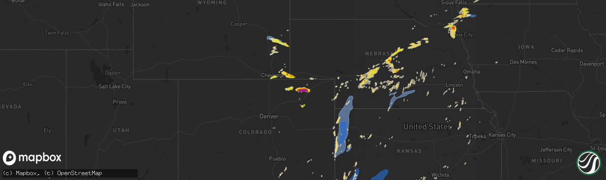
Hail Map on June 2, 2025
The weather event on June 2, 2025 includes Hail, Wind, and Tornado maps. 13 states and 665 cities were impacted and suffered possible damage. The total estimated number of properties impacted is 42,895.
Want more than just the map?
Turn this storm into a full workflow.
- Owner + property data so you know who to knock
- OnDemand branded weather history reports to win the "did we even have hail?" argument
- RoofTrace estimate so reps stop guessing numbers at the door
Bought this map? Upgrade within 7 days and we'll credit the $230. (10-15 min setup call)
Hail
Wind
Tornado
42,895
Estimated number of impacted properties by a 1.00" hail or larger5,931
Estimated number of impacted properties by a 1.75" hail or larger0
Estimated number of impacted properties by a 2.50" hail or largerStates Impacted by Hail Map on June 2, 2025
Storm reports
Nebraska
| Date | Description |
|---|---|
| 06/02/20256:48 PM CDT | Photo of several 1 inch hail stones and report of minor street flooding 638 to 648pm cdt. |
| 06/02/20256:39 PM CDT | A local report indicates 1.50 inch wind near 3 E Gates |
| 06/02/20256:39 PM CDT | Trained spotter reports ping pong ball size hail. |
| 06/02/20256:34 PM CDT | A local report indicates 1.00 inch wind near North Platte |
| 06/02/20256:31 PM CDT | Pws peak wind gust. |
| 06/02/20256:25 PM CDT | A local report indicates 70 MPH wind near Broken Bow |
| 06/01/202511:08 PM CDT | Small area of tree damage. Barn damaged. |
| 06/01/202510:54 PM CDT | Personal weather station reports gust to 64mph. |
| 06/01/202510:52 PM CDT | Personal weather station reports gust to 73mph. |
| 06/01/202510:40 PM CDT | Fire chief reports power poles down in kennesaw. |
| 06/01/202510:35 PM CDT | Personal weather station reports gust to 63mph. |
| 06/01/202510:34 PM CDT | Personal weather station reports gust to 72mph. |
| 06/01/202510:33 PM CDT | Personal weather station gust to 66mph. |
| 06/01/202510:32 PM CDT | Personal weather station gust to 58mph. |
| 06/01/202510:29 PM CDT | Personal weather station gust to 65mph. |
| 06/01/202510:28 PM CDT | Personal weather station gust to 62mph. |
| 06/01/202510:28 PM CDT | Personal weather station gust to 62mpph. |
| 06/01/202510:27 PM CDT | Photo on social media of tree damage in kearney. |
| 06/01/202510:27 PM CDT | Corrects previous tstm wnd gst report from 3 nne kearney. Personal weather station reports gust to 63mph. |
| 06/01/202510:27 PM CDT | Photo on social media of tree damage in kearney. |
| 06/01/202510:27 PM CDT | Photo on social media of tree damage in kearney. |
| 06/01/202510:25 PM CDT | Photo sent in of a car port covering blown on top of a mobile home. |
| 06/01/202510:25 PM CDT | Image sent in of a fallen tree. Hail under 1 inch and shingle damage was additionally reported. |
| 06/01/202510:20 PM CDT | Picture sent in of a large tree limb... Greater than 1 foot in diameter... Down across a car. |
| 06/01/202510:20 PM CDT | Pictures sent in of a few downed 6 inch estimated tree limbs. |
| 06/01/202510:20 PM CDT | Photo sent in of a large tree snapped in half. |
| 06/01/202510:12 PM CDT | Personal weather station gust to 58mph. |
| 06/01/202510:02 PM CDT | Awos reports gust to 61mph. |
| 06/01/202510:00 PM CDT | Personal weather station gust to 63mph. |
| 06/01/20259:56 PM CDT | Personal weather station gust to 64mph. |
| 06/01/20259:54 PM CDT | Personal weather station gust to 63mph. |
| 06/01/20259:40 PM CDT | Personal weather station gust to 64mph. |
| 06/01/20258:40 PM CDT | A local report indicates 58 MPH wind near 1 ESE Imperial |
| 06/01/20258:24 PM CDT | Weather link site parman reports 62 mph wind gust. |
| 06/01/20258:18 PM CDT | Lorens farm awn 64 mph gust. |
| 06/01/20258:16 PM CDT | Awn site ellis reports 58 mph wind gust. |
| 06/01/20258:11 PM CDT | Awn site lorens farm reports 64 mph wind gust. |
| 06/01/20258:10 PM CDT | Tree uprooted and fallen on a house in town. |
| 06/01/20257:16 PM CDT | The public estimated a 6 inch in diameter tree branch down. |
| 06/01/20257:08 PM CDT | Delayed report. Power poles damaged. Time estimated by radar. |
| 06/01/20257:03 PM CDT | In addition to quarter sized hail... 60-70 mph estimated winds blew over the rain gauge and broke some sticks. Rainfall was at least 1 inch. |
South Dakota
| Date | Description |
|---|---|
| 06/02/20256:15 PM CDT | Quarter to ping pong ball size hail. |
| 06/02/20256:10 PM CDT | Ping pong to golf ball size hail between mile markers 19 and 22 on interstate 29. A semi truck ran into another semi truck in the adjoining lane due to poor visibility |
| 06/02/20256:00 PM CDT | Large trees down across burbank road. |
| 06/02/20255:54 PM CDT | Tree and structure damage to an agricultural themed event venue. Fence at property also blown over. Additional damage 1 mile southeast of property on burbank road to ne |
| 06/02/20255:52 PM CDT | Machine shed destroyed with debris blown across road. A few large limbs broken off trees. Grain bin dented. |
| 06/02/20255:22 PM CDT | Report via social media. |
| 06/02/20255:21 PM CDT | A local report indicates 1.00 inch wind near Vermillion |
| 06/02/20255:21 PM CDT | Storage building destroyed by severe winds. 2.4 inches of rainfall in 15 to 20 minutes. Pea to dime sized hail. |
| 06/02/20255:20 PM CDT | Several large trees limbs down along with one large tree leaning on a house. Winds estimated at least 60 mph. |
Kansas
| Date | Description |
|---|---|
| 06/02/20256:54 PM CDT | A local report indicates 80 MPH wind near Sharon Springs |
| 06/02/20256:53 PM CDT | Awn site section 22 reports 64 mph wind gust. |
| 06/02/20256:50 PM CDT | Delayed report. |
| 06/02/20256:49 PM CDT | Ks-wallace. |
| 06/02/20256:44 PM CDT | Weather link site farm location reports 59 mph wind gust. |
| 06/02/20256:36 PM CDT | Weather link site section 32 reports 71 mph wind gust. |
| 06/02/20256:27 PM CDT | Report received from awn casade rodney observation site. |
| 06/02/20256:17 PM CDT | Nw_tribune_ks_ |
| 06/02/20255:30 PM CDT | A local report indicates 70 MPH wind near 5 W Liberal |
| 06/02/20255:15 PM CDT | Awos station keha elkhart awos site. |
| 06/02/20254:28 PM CDT | A local report indicates 1.00 inch wind near 4 SE Rolla |
| 06/02/20254:38 AM CDT | Delayed report... Courtesy of ksu mesonet. |
| 06/01/20259:55 PM CDT | Awos station koin oberlin decaying showers in the area. |
| 06/01/20259:27 PM CDT | Awn site selden reports 61 mph wind gust. |
| 06/01/20259:14 PM CDT | Pws site kksselde20 reports 58 mph wind gust. |
| 06/01/20258:35 PM CDT | Awos station koin oberlin. |
| 06/01/20258:29 PM CDT | Trained spotter reports winds around 40 with gusts to 60 mph. |
| 06/01/20258:25 PM CDT | Report of 60 mph winds between 8:15-8:30 pm lt. |
| 06/01/20258:25 PM CDT | Kzlf transmitter site. |
| 06/01/20258:15 PM CDT | Awos station ksyf st. Francis city. |
| 06/01/20258:10 PM CDT | Ksyf reports wind gust of 61 mph. |
| 06/01/20257:59 PM CDT | Awn site 3350 reports 62 mph wind gust. |
| 06/01/20257:58 PM CDT | Two inch diameter tree limb blown down. |
| 06/01/20257:50 PM CDT | Trained spotter estimates 60-70 mph wind gust. |
| 06/01/20257:47 PM CDT | Awn site 1730 rd q reports 62 mph wind gust. |
| 06/01/20257:46 PM CDT | Koel reports 67 mph wind gust with half mile visibility. |
| 06/01/20257:30 PM CDT | Corrects previous tstm wnd dmg report from 1 w edson. Camper tipped over on i-70 mm 26 westbound lanes on i-70 blocked at this location due to overturned vehicles. |
| 06/01/20257:30 PM CDT | Camper tipped over on i-70 mm 26. |
| 06/01/20257:30 PM CDT | Report of numerous blow overs from mm 32 east to mm 36 on i-70. |
| 06/01/20257:28 PM CDT | Downed limbs along the 900 block of broadway. |
| 06/01/20257:23 PM CDT | Awn site cm_kistler reports 58 mph wind gust. |
| 06/01/20257:19 PM CDT | Kgld reports 74 mph wind gust. |
| 06/01/20257:19 PM CDT | Weather link site rietcheck farms reports 79 mph wind gust. |
| 06/01/20257:19 PM CDT | Asos station kddc dodge city regional airport. |
Wyoming
| Date | Description |
|---|---|
| 06/02/20256:27 PM CDT | Emergency manager reports down trees and power outages around torrington. |
| 06/02/20256:15 PM CDT | Report from mping: half dollar |
| 06/02/20255:48 PM CDT | Picture on social media showing half dollar size hail. |
| 06/02/20255:27 PM CDT | Picture on social media showing quarter size hail. |
| 06/02/20255:09 PM CDT | Camp guernsey airport gust 64 mph. |
| 06/02/20254:52 PM CDT | Wydot sensor at coleman on interstate 25 measured a wind gust of 59 mph. |
| 06/02/20254:51 PM CDT | Report of quarter size hail. |
| 06/01/20259:37 PM CDT | Em shared picture in slack of a newer-build barn with the roof ripped off and laying on the camper next to it. |
Oklahoma
| Date | Description |
|---|---|
| 06/02/20256:41 PM CDT | Report from mping: quarter |
| 06/02/20254:35 PM CDT | A local report indicates 58 MPH wind near 3 SSE Boise City |
| 06/01/20258:52 PM CDT | A local report indicates 60 MPH wind near Cheyenne |
| 06/01/20257:35 PM CDT | Trees uprooted. Mping report. Time estimated from radar. |
| 06/01/20257:33 PM CDT | A local report indicates 74 MPH wind near 1 W Burns Flat |
| 06/01/20257:31 PM CDT | Report from mping: half dollar |
| 06/01/20257:15 PM CDT | A local report indicates 66 MPH wind near 6 SSE Elk City |
Colorado
| Date | Description |
|---|---|
| 06/02/20255:59 PM CDT | Mesonet station ucnc2 ute canyon. |
| 06/02/20255:26 PM CDT | Asos station kspd 8 s springfield. |
| 06/02/20255:24 PM CDT | Reported from kspd asos. |
| 06/01/20259:06 PM CDT | Mesonet station co035 i-76 sterling. |
| 06/01/20259:00 PM CDT | A local report indicates 1.50 inch wind near Sterling |
| 06/01/20258:50 PM CDT | A local report indicates a tornado near 4 ESE Logan Corners |
| 06/01/20258:41 PM CDT | A local report indicates 2.00 inch wind near 3 E Logan Corners |
| 06/01/20258:25 PM CDT | A local report indicates a tornado near 1 W Pawnee Pass |
| 06/01/20258:20 PM CDT | A local report indicates 2.00 inch wind near 5 WSW Pawnee Pass |
| 06/01/20257:55 PM CDT | Highway completely covered by hail. |
| 06/01/20257:47 PM CDT | A local report indicates 1.00 inch wind near 2 NW Stoneham |
Florida
| Date | Description |
|---|---|
| 06/02/202510:12 AM CDT | Report of 1.5-inch hail near intersection of i-4 and hwy 301. |
| 06/02/202510:10 AM CDT | A few reports of quarter size hail near the florida state fairgrounds. |
Texas
| Date | Description |
|---|---|
| 06/02/20256:43 PM CDT | Asos station kfst fort stockton. |
| 06/02/20256:43 PM CDT | Report of a fence and backyard antenna tower blown over. Time estimated by radar. |
| 06/02/20256:42 PM CDT | Corrects previous tstm wnd dmg report from fort stockton. Approximately 50 homes had minor roof damage and 20 power poles were broken due to severe winds and hail in th |
| 06/02/20256:42 PM CDT | Multiple reports of wind damage to power poles... Roofs... And older buildings in fort stockton. Time estimated by radar. |
| 06/02/20256:40 PM CDT | A single wide mobile home was reported to have been rolled on its side in the southeast part of fort stockton. Location is approximate. The time is estimated from radar |
| 06/02/20256:39 PM CDT | Approximately five power poles were reported to have been broken near the base near alamo elementary school. A wall of a nearby building was also partially blown inward |
| 06/02/20256:38 PM CDT | Metal roof panels were torn away from the baseball dugouts at pat taylor field. The time is estimated from radar. |
| 06/02/20255:59 PM CDT | A local report indicates 63 MPH wind near Smyer |
| 06/02/20255:58 PM CDT | Also up to nickel-sized hail. |
| 06/02/20255:33 PM CDT | A local report indicates 58 MPH wind near 6 ESE Lora |
| 06/02/20253:55 PM CDT | Multiple 1 inch diameter... And slightly larger tree branches snapped. |
| 06/02/20253:46 PM CDT | A local report indicates 70 MPH wind near 4 WNW Stratford |
| 06/02/20253:44 PM CDT | Tree and roof damage reported from severe thunderstorm outflow wind gusts. |
| 06/02/20253:44 PM CDT | West texas mesonet report. |
| 06/02/20253:41 PM CDT | A local report indicates 60 MPH wind near 3 NNE Umbarger |
| 06/02/20253:34 PM CDT | Multiple severe gusts of 59 to 63 mph starting around 3:25 pm and continuing through 3:35 pm. |
| 06/02/20253:30 PM CDT | A local report indicates 58 MPH wind near 1 NNW Lubbock Int. Airp |
| 06/02/20253:26 PM CDT | West texas mesonet report. |
| 06/02/20253:26 PM CDT | A local report indicates 61 MPH wind near 1 W Canyon |
| 06/02/20253:23 PM CDT | A local report indicates 58 MPH wind near 3 SW Dalhart |
| 06/02/20253:16 PM CDT | West texas mesonet report. Additional 58 mph gust also occurred at 3:20 pm cdt. |
| 06/02/20252:46 PM CDT | Updates previous tstm wnd gst report from 2 ne dimmitt. Peak gust from west texas mesonet. Severe gusts from 2:45 to 2:48 pm cdt. Additional severe gusts from 2:52 to 2 |
| 06/02/20252:46 PM CDT | Peak gust from west texas mesonet. Severe gusts from 2:45 to 2:48 pm cdt. |
| 06/02/20252:44 PM CDT | Delayed report. Public report received via social media of straight line wind damage south of amarillo. Pictures and video provided showed roofing blown off a metal out |
| 06/02/20252:21 PM CDT | West texas mesonet. |
| 06/02/20251:42 PM CDT | Corrects previous non-tstm wnd gst report from 11 wnw bootleg. |
| 06/02/20252:18 AM CDT | Report from mping: ping pong ball |
| 06/02/20252:12 AM CDT | 1 mobile home damaged... Another destroyed. P |
| 06/02/20252:12 AM CDT | 1 mobile home damaged... Another destroyed. Power out in the area. |
| 06/02/20252:12 AM CDT | A local report indicates 1.50 inch wind near 9 S Odessa |
| 06/02/20252:12 AM CDT | 1 mobile home damaged... Another destroyed. Power out in t |
| 06/02/20252:12 AM CDT | 1 mobile home damaged... A |
| 06/02/20252:12 AM CDT | 1 mobile home damaged... Another destroyed. Power out i |
| 06/02/20252:12 AM CDT | 1 mobile home dam |
| 06/02/20252:12 AM CDT | 1 mobile |
| 06/02/20252:12 AM CDT | 1 |
| 06/02/20252:12 AM CDT | 1 mobile home damaged... Another destr |
| 06/02/20252:10 AM CDT | *** 2 inj *** a single wide manufactured home was completely destroyed by straight-line winds from a microburst. The time is esti |
| 06/02/20252:10 AM CDT | Two single wide mobile homes were completely destroyed and a third was damaged due to straight-line winds from a microburst. Additionally... Two power poles were broken |
| 06/02/20252:10 AM CDT | *** 2 inj *** a single wide manufactured home was completely destroyed by straight-line winds from a microburst. The time is estimated from radar. |
| 06/02/20252:10 AM CDT | A single wide manufactured home was rolled onto its side onto two vehicles. This resulted in significant damage to the home and vehicles. The time is estimated from rad |
| 06/02/20252:09 AM CDT | A single wide mobile home was rolled onto its side towards the northeast... A portion of a metal roof panel was removed and blown across the street towards the northeas |
| 06/02/20252:08 AM CDT | Two single wide mobile homes lost their roofs and most walls. The time is estimated from radar. |
| 06/02/202512:17 AM CDT | 61 mph thunderstorm wind gust reported by mesonet station 25 in seminole. |
| 06/01/202511:45 PM CDT | Asos station kama amarillo |
| 06/01/20259:20 PM CDT | Fence blown down by thunderstorm winds. |
| 06/01/20257:31 PM CDT | Media viewer reported. |
| 06/01/20257:28 PM CDT | A local report indicates 70 MPH wind near 3 NNE Tahoka |
Minnesota
| Date | Description |
|---|---|
| 06/02/20256:35 PM CDT | Awos station kulm new ulm ap. |
| 06/02/20256:34 PM CDT | A dead... 2 foot diameter tree downed along 5th north street. Time estimated from radar. |
| 06/02/20256:34 PM CDT | Several large trees snapped at their base in german park. Time estimated from radar. |
| 06/02/20256:33 PM CDT | Several downed trees near the new ulm medical center. Time estimated from radar. |
| 06/02/20256:32 PM CDT | Delayed report from brown county spotters social media. Large tree branch down in sleepy eye mn... Time estimated from radar. |
| 06/02/20256:25 PM CDT | Tin roofing removed from a shed. Time estimated based on radar. |
| 06/02/20255:41 PM CDT | A few birch trees were downed from southwest to northeast and on the shoulder of us2. |
| 06/02/20255:41 PM CDT | Image of powerlines down... Confirmed by county officials on hwy 5 south of bird island. |
| 06/02/20255:35 PM CDT | Delayed report... Time estimated from radar. Lots of nickel to quarter size hail. |
| 06/02/20255:16 PM CDT | Delayed report... Time estimated from radar. Powerlines down 4 north of cosmos. |
| 06/02/20255:12 PM CDT | A local report indicates 1.25 inch wind near 1 ENE Olivia |
| 06/02/20255:11 PM CDT | Delayed report... Time estimated from radar. Half dollar sized hail near cr11 north of olivia. |
| 06/02/20255:08 PM CDT | Delayed report... Time estimated from radar of a few trees down and a semi flipped over on hwy 71 just north of olivia... Mn. |
| 06/02/20255:01 PM CDT | Delayed report... Time estimated from radar. Trees down on a property west of lake elizabeth. |
| 06/02/20255:00 PM CDT | Delayed report... Time estimated from radar. Photo of several downed power lines near roseland shared via x. |
| 06/02/20254:59 PM CDT | Report of damage to a metal outbuilding. |
| 06/02/20252:45 PM CDT | Wind gust estimated 55 to 60 mph... Scouring dirt from the fields creating near zero visibility for a brief time. |
| 06/02/20252:40 PM CDT | Measured by mndot rwis along hwy 9. |
| 06/02/20252:35 PM CDT | Several trees down... Including one on a trailer. Time estimated based on radar. |
| 06/02/20252:30 PM CDT | Several trees down... Including one on a farm building. Time estimated based on radar. |
| 06/02/20252:30 PM CDT | Measured at alexandria airport. |
| 06/02/20252:30 PM CDT | Trees and power lines reported down in glenwood. Time estimated based on radar. |
| 06/02/20252:25 PM CDT | Boat lifts and canopies overturned on lake reno. Time estimated based on radar. |
| 06/02/20252:20 PM CDT | Trees and power lines reported down in starbuck. Time estimated based on radar. |
| 06/02/20252:13 PM CDT | 61 mph gust measured with personal weather station. |
| 06/02/20252:10 PM CDT | A local report indicates 60 MPH wind near Barrett |
| 06/02/20251:55 PM CDT | Ten to 16 inch diameter trees and various limbs snapped off at a residence north of morris along hwy 59. Time estimated based on radar. |
| 06/02/20251:50 PM CDT | Two power poles snapped along highway 9. Young corn stalks were also damaged. Time estimated based on radar. Damage to more power poles... Trees and some outbuildings c |
| 06/02/20251:47 PM CDT | Ndawn observation site. |
| 06/02/20251:46 PM CDT | Ndawn observation. |
New Mexico
| Date | Description |
|---|---|
| 06/02/20256:07 PM CDT | Power lines down at mile markers 53-55 on highway 128 east of jal. Time estimated by radar. |
| 06/02/20252:13 PM CDT | Mesonet station gw0819 clovis. |
| 06/02/20252:08 PM CDT | Mesonet station gw0819 clovis. |
| 06/02/20252:06 PM CDT | Awos station kcvs cannon air force base. |
| 06/02/20252:01 PM CDT | Awos station kcvs cannon air force base. |
Iowa
| Date | Description |
|---|---|
| 06/02/20256:39 PM CDT | Wind destroyed a hog barn with debris on highway 60. |
| 06/02/20255:20 PM CDT | Hail from dime to quarter size. |
| 06/02/20255:05 PM CDT | Yard is covered with various sizes of hail... Many with flat tops from the briefly heavy rain. |
| 06/02/20254:16 PM CDT | Report from mping: quarter |
| 06/02/20254:12 PM CDT | Half dollar to ping pong size hail. |
| 06/01/20258:06 PM CDT | A local report indicates 1.75 inch wind near 7 N Ireton |
Cities Impacted by Hail Map on June 2, 2025
- Goree, TX
- Tampa, FL
- Gibsonton, FL
- Riverview, FL
- Brandon, FL
- Boca Grande, FL
- Seffner, FL
- Dimmitt, TX
- Adrian, TX
- Vega, TX
- Brentford, SD
- Immokalee, FL
- Mellette, SD
- Conde, SD
- Stratford, SD
- Miami, FL
- Opa Locka, FL
- Hollywood, FL
- Ortley, SD
- Hialeah, FL
- Peever, SD
- Grenville, SD
- Summit, SD
- Wilmot, SD
- Aguilar, CO
- Fort Lauderdale, FL
- Walsenburg, CO
- Bovina, TX
- Milbank, SD
- Beardsley, MN
- Ortonville, MN
- Clinton, MN
- Stockholm, SD
- Ochopee, FL
- Miami Gardens, FL
- Browns Valley, MN
- Quemado, NM
- Friona, TX
- Dumont, MN
- Graceville, MN
- Twin Brooks, SD
- Barry, MN
- Pompano Beach, FL
- Appleton, MN
- Chokio, MN
- Key Biscayne, FL
- Hereford, TX
- Boca Raton, FL
- Deerfield Beach, FL
- Morris, MN
- Hancock, MN
- Cyrus, MN
- Alberta, MN
- Holloway, MN
- Donnelly, MN
- Herman, MN
- Barrett, MN
- Norcross, MN
- Elbow Lake, MN
- Ashby, MN
- Evansville, MN
- Danvers, MN
- Delray Beach, FL
- Benson, MN
- Clontarf, MN
- Kensington, MN
- Starbuck, MN
- Hoffman, MN
- Garfield, MN
- Brandon, MN
- Farwell, MN
- Alexandria, MN
- Dalton, MN
- Battle Lake, MN
- Glenwood, MN
- Lowry, MN
- Villard, MN
- Carlos, MN
- Clitherall, MN
- Parkers Prairie, MN
- Miltona, MN
- Vining, MN
- Texico, NM
- Broadview, NM
- Clovis, NM
- Cannon Afb, NM
- Portales, NM
- Nelson, MN
- Osakis, MN
- Murdock, MN
- Brooten, MN
- Sunburg, MN
- Pennock, MN
- Belgrade, MN
- Sauk Centre, MN
- New London, MN
- Henning, MN
- Elrosa, MN
- Melrose, MN
- Deer Creek, MN
- Wadena, MN
- Hewitt, MN
- West Union, MN
- Happy, TX
- Canyon, TX
- Dalhart, TX
- Channing, TX
- Hartley, TX
- Augusta, AR
- Balmorhea, TX
- Laguna, NM
- Tulia, TX
- Silverton, TX
- Amarillo, TX
- Kress, TX
- Montevideo, MN
- Madison, MN
- Albuquerque, NM
- Clewiston, FL
- Bosque Farms, NM
- Maynard, MN
- Watson, MN
- Alcester, SD
- Lubbock, TX
- Idalou, TX
- Petersburg, TX
- Abernathy, TX
- New Deal, TX
- Hale Center, TX
- Wayside, TX
- Claude, TX
- Fritch, TX
- Panhandle, TX
- Stratford, TX
- Groom, TX
- Floydada, TX
- Clara City, MN
- Hudson, SD
- Kerkhoven, MN
- Plainview, TX
- Nazareth, TX
- Clarendon, TX
- Quitaque, TX
- Van Tassell, WY
- Hawarden, IA
- Rock Valley, IA
- Raymond, MN
- Lovington, NM
- Palm City, FL
- Indiantown, FL
- Tokio, TX
- Sioux Center, IA
- Rolla, KS
- Meadow, TX
- Castle Rock, CO
- Guymon, OK
- Franktown, CO
- Stinnett, TX
- White Deer, TX
- Pampa, TX
- Skellytown, TX
- Borger, TX
- Willmar, MN
- Fairview, SD
- Hugoton, KS
- Richfield, KS
- Texhoma, OK
- Keyes, OK
- Boise City, OK
- Lockney, TX
- Slaton, TX
- Ransom Canyon, TX
- Fort Stockton, TX
- Hector, MN
- Sacred Heart, MN
- Big Falls, MN
- Glendo, WY
- Renville, MN
- Cheyenne, WY
- Inwood, IA
- Doon, IA
- Granite Falls, MN
- Spicer, MN
- Prinsburg, MN
- Danube, MN
- Blomkest, MN
- Littlefork, MN
- Gruver, TX
- Spearman, TX
- Lake Lillian, MN
- Estancia, NM
- Broken Bow, NE
- Hardesty, OK
- Belen, NM
- Taylor, NE
- Burwell, NE
- Westbrook, MN
- Alvord, IA
- Mountainair, NM
- Anselmo, NE
- Johnson, KS
- Vermillion, SD
- Rock Rapids, IA
- Atwater, MN
- Wynot, NE
- Mclean, TX
- Perryton, TX
- Miami, TX
- Orr, MN
- Olivia, MN
- Manter, KS
- Grove City, MN
- Bird Island, MN
- Wheatland, WY
- Guernsey, WY
- Hartville, WY
- Newcastle, NE
- Ulysses, KS
- Rushmore, MN
- Kandiyohi, MN
- Cosmos, MN
- Lamberton, MN
- Storden, MN
- Burbank, SD
- Elk Point, SD
- George, IA
- Yoder, WY
- Fort Laramie, WY
- Jay Em, WY
- Orchard, NE
- Hooker, OK
- Moriarty, NM
- Sargent, NE
- Ewing, NE
- Chambers, NE
- Brady, NE
- Maxwell, NE
- Callaway, NE
- Litchfield, MN
- Redwood Falls, MN
- Hull, IA
- Tribune, KS
- Levelland, TX
- Ireton, IA
- Pecos, TX
- Worthington, MN
- Reading, MN
- Kendall, KS
- Lingle, WY
- Crane Lake, MN
- Morton, MN
- Franklin, MN
- Liberal, KS
- Tyrone, OK
- Burns, WY
- Brewster, MN
- Arnold, NE
- Hershey, NE
- Royal, NE
- Brunswick, NE
- Imperial, TX
- Satanta, KS
- Fairfax, MN
- Elbert, CO
- Plainview, NE
- Buffalo Lake, MN
- North Platte, NE
- Hollis, OK
- Merna, NE
- Carpenter, WY
- Clearwater, NE
- Lakin, KS
- Stapleton, NE
- Ropesville, TX
- Boyden, IA
- Orange City, IA
- Torrington, WY
- Kismet, KS
- Plains, KS
- Meade, KS
- Garden City, KS
- Holcomb, KS
- Morgan, MN
- Gould, OK
- Sleepy Eye, MN
- Pine Bluffs, WY
- Hospers, IA
- Sheldon, IA
- Ribera, NM
- Duke, OK
- Wolfforth, TX
- Smyer, TX
- Shallowater, TX
- Ponca, NE
- Lorenzo, TX
- Mobeetie, TX
- Canadian, TX
- Briscoe, TX
- Sheridan Lake, CO
- Mangum, OK
- Beaver, OK
- Vinson, OK
- Deerfield, KS
- Neligh, NE
- Veguita, NM
- Leoti, KS
- Balko, OK
- Lipscomb, TX
- Higgins, TX
- Booker, TX
- Laverne, OK
- Darrouzett, TX
- Follett, TX
- Gothenburg, NE
- Bushnell, NE
- Dixon, NE
- Gate, OK
- Winona, KS
- Jefferson, SD
- New Ulm, MN
- Gibbon, MN
- Winthrop, MN
- Lafayette, MN
- Lake Crystal, MN
- Courtland, MN
- Mankato, MN
- Nicollet, MN
- Saint Peter, MN
- Archer, IA
- Willow, OK
- Briggsdale, CO
- Tahoka, TX
- Weskan, KS
- Sayre, OK
- Fowler, KS
- Granite, OK
- Sharon Springs, KS
- Erick, OK
- Burlington, CO
- Yeso, NM
- Ansley, NE
- Westerville, NE
- Waterbury, NE
- Allen, NE
- Roswell, NM
- Rosston, OK
- Carter, OK
- Wallace, KS
- Edson, KS
- Goodland, KS
- Kanorado, KS
- Dill City, OK
- Sentinel, OK
- Cheyenne, OK
- Jackson, NE
- Ashland, KS
- Oakley, KS
- Oneill, NE
- Brewster, KS
- Emerson, NE
- Hubbard, NE
- Grinnell, KS
- Gove, KS
- Canute, OK
- Socorro, NM
- Hammon, OK
- Willard, NM
- Grant, NE
- New Raymer, CO
- Alamo, NV
- Leedey, OK
- Englewood, KS
- Forgan, OK
- Grainfield, KS
- Reydon, OK
- Sharon, OK
- Lynch, NE
- Fort Sumner, NM
- Wilson, TX
- Grover, CO
- Oconto, NE
- Madrid, NE
- Saint Francis, KS
- Foss, OK
- Mason City, NE
- Elsie, NE
- Wellfleet, NE
- Stoneham, CO
- Clinton, OK
- Venango, NE
- Mutual, OK
- Mooreland, OK
- Comstock, NE
- Park, KS
- Scotland, SD
- Vici, OK
- Arapaho, OK
- Las Vegas, NM
- Encino, NM
- Litchfield, NE
- Bessie, OK
- Corn, OK
- Merino, CO
- Taiban, NM
- Utica, KS
- Quinter, KS
- Waynoka, OK
- Ord, NE
- Ransom, KS
- Adrian, MN
- Chester, OK
- Weatherford, OK
- Imperial, NE
- Sweetwater, OK
- Hurley, SD
- Davis, SD
- Camargo, OK
- Taloga, OK
- Seiling, OK
- Alva, OK
- Hardtner, KS
- Ellis, KS
- Bigelow, MN
- Sterling, CO
- Arcadia, NE
- Loup City, NE
- Benkelman, NE
- Thomas, OK
- Custer City, OK
- Dodson, TX
- Brownell, KS
- Kiowa, KS
- Hazelton, KS
- Burlington, OK
- Fairview, OK
- Atwood, CO
- Elk City, OK
- Butler, OK
- Champion, NE
- Lenora, KS
- Haigler, NE
- Wallace, NE
- Wauneta, NE
- Aline, OK
- McDonald, KS
- Bird City, KS
- Stratton, NE
- Max, NE
- Palisade, NE
- Dodge City, KS
- Minneola, KS
- Wright, KS
- Ensign, KS
- Spearville, KS
- Montezuma, KS
- Ford, KS
- Peetz, CO
- Watonga, OK
- Wray, CO
- Snyder, CO
- Brush, CO
- Lexington, NE
- Cozad, NE
- Carmen, OK
- Dacoma, OK
- Fay, OK
- Dickens, NE
- Arnett, OK
- Cherokee, OK
- Fleming, CO
- Akron, CO
- Farnam, NE
- Eustis, NE
- Wellington, TX
- Moorefield, NE
- Stockville, NE
- Sidney, NE
- Canton, OK
- Miller, NE
- Amorita, OK
- Hayes Center, NE
- Maywood, NE
- Almena, KS
- Long Island, KS
- Curtis, NE
- Stamford, NE
- Eddyville, NE
- Elwood, NE
- Hitchcock, OK
- Okeene, OK
- Helena, OK
- Bertrand, NE
- Hazard, NE
- Loomis, NE
- Grandfalls, TX
- Cordell, OK
- Overton, NE
- Sumner, NE
- Orleans, NE
- Pleasanton, NE
- Beresford, SD
- Gail, TX
- Jet, OK
- Kingfisher, OK
- Crane, TX
- Elm Creek, NE
- Nash, OK
- Holdrege, NE
- Bloomington, NE
- Ames, OK
- Hennessey, OK
- Geary, OK
- Amherst, NE
- Kearney, NE
- Minden, NE
- Riverdale, NE
- Brule, NE
- Oakwood, OK
- Odessa, NE
- Franklin, NE
- Hildreth, NE
- Upland, NE
- Ravenna, NE
- Waukomis, OK
- Riverton, NE
- Cleo Springs, OK
- Longdale, OK
- Southard, OK
- Kenesaw, NE
- Shelton, NE
- Gibbon, NE
- Justiceburg, TX
- Odessa, TX
- Douglas, OK
- Greenfield, OK
- McCamey, TX
- Wood River, NE
- Midkiff, TX
- Doniphan, NE
- Enochs, TX
- Colony, OK
- Fairmont, OK
- Grand Island, NE
- Omega, OK
- Morton, TX
- Sudan, TX
- Cairo, NE
- Alda, NE
- Saint Paul, NE
- Palmer, NE
- Sutton, NE
- Midland, TX
- Edgar, NE
- Chapman, NE
- Marquette, NE
- Aurora, NE
- Saint Libory, NE
- Central City, NE
- Leonardville, KS
- Riley, KS
- Palmer, KS
- Linn, KS
- Green, KS
- Archer, NE
- Hydro, OK
- Hinton, OK
- Saint George, KS
- Westmoreland, KS
- Barnes, KS
- Loyal, OK
- Western, NE
- Dover, OK
- Odell, NE
- Clatonia, NE
- Garden City, TX
- Dorchester, NE
- Crete, NE
- Wilber, NE
- Lamesa, TX
- Ackerly, TX
- Stromsburg, NE
- Clarks, NE
- Beatrice, NE
- Greenleaf, KS
- Steele City, NE
- Brownfield, TX
- Diller, NE
- Wymore, NE
- Osceola, NE
- Silver Creek, NE
- Benedict, NE
- Seminole, TX
- Hallam, NE
- Cortland, NE
- Beattie, KS
- Blue Springs, NE
- Odonnell, TX
- Kermit, TX
- Burchard, NE
- Sprague, NE
- Roca, NE
- Martell, NE
- Post, TX
- Paxico, KS
- Fluvanna, TX
- Corning, KS
- Schuyler, NE
- Columbus, NE
- Steinauer, NE
- Tecumseh, NE
- Lewiston, NE
- Eskridge, KS
- Harveyville, KS
- Goldsmith, TX
- Maple Hill, KS
- Pawnee City, NE
- Goff, KS
- Oxford, NE
- Wilcox, NE
- Heartwell, NE
- Atlanta, NE
- Roseland, NE
- Holstein, NE
- Alma, NE
- Juniata, NE
- Axtell, NE
- Funk, NE
- Topeka, KS
- Gardendale, TX
- North Bend, NE
- Andrews, TX
- Ames, NE
- Hooper, NE
- Stanton, TX
- Muscotah, KS
- Louisville, NE
- Rulo, NE
- Crawford, OK
- Durham, OK
- Springfield, NE
- Buffalo, OK
- Medicine Lodge, KS
- Wilmore, KS
- Isabel, KS
- Protection, KS
- Nashville, KS
- Coldwater, KS
- Big Lake, TX
- Zenda, KS
- Spivey, KS
- Kingman, KS
- Exira, IA
- Brayton, IA
- Dryden, TX
- Murdock, KS
- Milton, KS
- Barnhart, TX
- Clearwater, KS
- Viola, KS
- Ozona, TX
- Conway Springs, KS
- Whitewater, KS
- Potwin, KS
- Comstock, TX
- Madison, KS