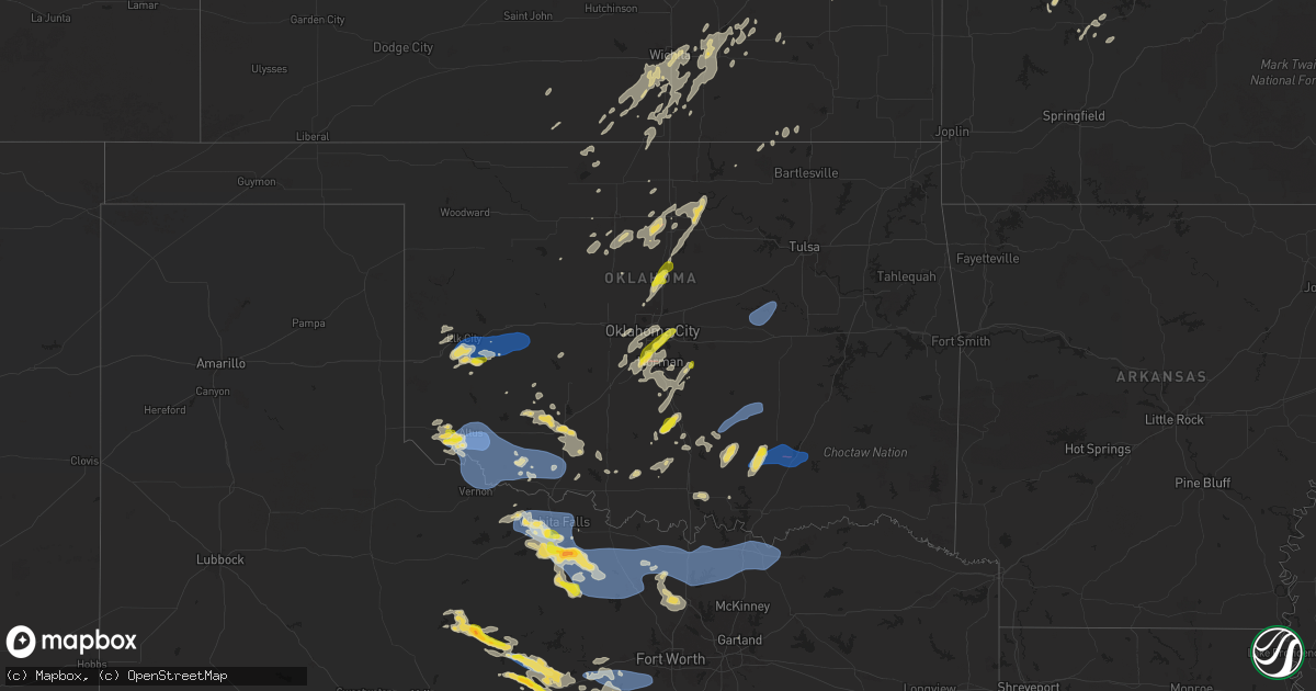
Hail Map on June 3, 2025
Get this storm
June 3 map
$229
one time, instant access
Download today. No call, no setup
Keep the $229
Bought the map and want the full workflow? Apply the entire $229 to a subscription within 7 days. None of it is wasted.
Every map, not just this one
This buys you this map. Subscription and you get every map we run, in the markets you choose from a few cities to whole states to nationwide. Plus real-time alerts the moment a storm fires.
Contact data
Name, contact info, occupancy, even credit band for addresses in the footprint. You go from where it hit to who to call.
Become the source they trust
Unlimited branding weather history reports on demand. You already have the documented answer ready for the property owner, and you are the one who showed up with it.
Property data and RoofTrace estimates
Pull up any address you have got, its value and the exact code rules for that jurisdiction, straight from One Click Code. Then RoofTrace estimates the squares, pitch, and roof value, priced the way you price.
States Impacted by Hail Map on June 3, 2025
Storm reports
Florida
| Date | Description |
|---|---|
| 06/03/20254:22 PM CDT | Fallen trees or limbs resulted in a power outage along dogwood drive. |
| 06/03/20254:14 PM CDT | Fallen trees or limbs resulted in a power outage along eddins lane. |
| 06/03/20254:10 PM CDT | Tree down near the intersection of navajo trail and spring creek highway. |
| 06/03/20254:05 PM CDT | Tree down on doctor martin luther king jr memorial road. |
| 06/03/20251:50 PM CDT | A tree fell onto the interstate 95 northbound blocking the middle and right lanes near at mile marker 320 which is south of international golf parkway and north of stat |
Texas
| Date | Description |
|---|---|
| 06/03/20256:56 PM CDT | A local report indicates 1.75 inch wind near 3 SSW Lake Arrowhead |
| 06/03/20256:10 PM CDT | Brief touchdown via photo evidence. Time estimated. |
| 06/03/20255:52 PM CDT | Report from mping: quarter |
| 06/03/20255:34 PM CDT | Power poles snapped/broken. Mping report. Time estimated from radar. |
| 06/03/20255:30 PM CDT | There were 5 trees blown down and numerous large branches were broken off at the fort griffin state historic site. |
| 06/03/20255:26 PM CDT | Powerlines blown down. Mping report. Time estimated from radar. |
| 06/03/20255:25 PM CDT | 3-inch tree branches broken. Mping report. Time is estimated from radar. |
| 06/03/20255:19 PM CDT | A local report indicates 74 MPH wind near 3 NW Lakeside City |
| 06/03/20255:17 PM CDT | A local report indicates 60 MPH wind near 1 N Iowa Park |
| 06/03/20255:16 PM CDT | Ksps. |
| 06/03/20255:13 PM CDT | A local report indicates 63 MPH wind near 2 NNW Lakeside City |
| 06/03/20255:05 PM CDT | Time estimated by radar. |
| 06/03/20251:26 AM CDT | Tree branches reported on county road 113. Time estimated by radar. |
| 06/03/202512:08 AM CDT | Large tree branches blocking road late night. Time estimated by radar. |
| 06/02/202511:58 PM CDT | Delayed report. A few transmission lines were damaged or snapped in this area near cr 263. Time estimated by radar. |
| 06/02/202511:15 PM CDT | Delayed report. Em reported one building suffered partial collapse of the roof. Time estimated by radar. |
| 06/02/202511:10 PM CDT | Mesonet station twb58 aquilla water supply district. |
| 06/02/202511:10 PM CDT | Mesonet station twb58 aquilla w |
| 06/02/202511:01 PM CDT | A few trees were blown down near denton tap road at hwy 121. |
| 06/02/202510:26 PM CDT | Report from mping: quarter |
| 06/02/202510:25 PM CDT | Media reports quarter sized hail falling in flat... Texas on highway 36. |
| 06/02/202510:20 PM CDT | Delayed report. Social media reported numerous trees snapped along county road 148 in bluff dale near the u.s. Highway 377. Time estimated by radar. |
| 06/02/202510:12 PM CDT | Measured wind gust of 62 mph in little elm by amateur radio. Sustained winds of 56 mph. |
| 06/02/20259:35 PM CDT | Facebook photos showed part of warehouse roof and wall collapsed near hwy 380 at western blvd. |
| 06/02/20259:31 PM CDT | Roof of an abandoned building blew into a gas station at 100 s first st in krum. No injuries. |
| 06/02/20259:31 PM CDT | Mping report received of quarter sized hail. |
| 06/02/20258:36 PM CDT | Trees down north of mineral wells. |
| 06/02/20257:30 PM CDT | A local report indicates 65 MPH wind near 9 NW Bowie |
Missouri
| Date | Description |
|---|---|
| 06/03/20255:59 PM CDT | Marion county dispatch reported a large tree blown onto power lines at the intersection of hamilton and dickerson streets... Knocking out power to about 100 residences. |
| 06/03/20255:59 PM CDT | Marion county dispatch reported a large tree blown onto power lines at the intersection of hamilton and dickerson streets... Knocking o |
| 06/03/20255:41 PM CDT | Corrects previous tstm wnd dmg report from 1 ne columbia. Wind gusts estimated at 50-55 mph. |
| 06/03/20255:06 PM CDT | Trees down blocking highway bb near rocheport. Time estimated from radar. |
| 06/03/20255:04 PM CDT | Knox county dispatch reported a tree down in the town of baring... Mo. Time estimated from radar. |
| 06/03/20255:01 PM CDT | Knox county dispatch reported power lines down in edina. Time estimated from radar. Dispatch received report at 5:15 pm. |
| 06/03/20255:00 PM CDT | Trees down. |
| 06/03/20254:56 PM CDT | Downed wires near county road 433. Time estimated from radar. |
| 06/03/20254:56 PM CDT | Downed wires near reed street. Time estimated from radar. |
| 06/03/20254:56 PM CDT | Downed tree and wires near halleck street. Time estimated from radar. |
| 06/03/20254:56 PM CDT | Downed tree and wires near county road 448. Time estimated from radar. |
| 06/03/20254:54 PM CDT | Downed tree and wires near chancellor street. Time estimated from radar. |
| 06/03/20254:52 PM CDT | Several downed trees and wires near county road 419. Time estimated from radar. |
| 06/03/20254:50 PM CDT | Downed tree limbs and wires near route 240. Time estimated from radar. |
| 06/03/20254:49 PM CDT | Reports of downed tree limbs in the macon area. Time estimated from radar. |
| 06/03/20254:48 PM CDT | Multiple broken power poles south of fayette. Time estimated from radar. |
| 06/03/20254:48 PM CDT | Downed tree and wires near sycamore street. Time estimated from radar. |
| 06/03/20254:48 PM CDT | Social media video of a downed tree at a residence. Time estimated from radar. |
| 06/03/20254:47 PM CDT | Mping report of downed tree limbs near holiday acres lake. Time estimated from radar. |
| 06/03/20254:45 PM CDT | Downed wires and power outages near billingsville road. Time estimated from radar. |
| 06/03/20254:45 PM CDT | Downed tree and wires near logan street. Time based on dispatch report and confirmed from radar. |
| 06/03/20254:45 PM CDT | Downed tree and wires near sportsman road. Time estimated from radar. |
| 06/03/20254:42 PM CDT | Tree limbs downed in la plata along us highway 63. |
| 06/03/20254:39 PM CDT | Downed wires near county road 345. Time estimated from radar. |
| 06/03/20254:35 PM CDT | Downed wires near route 3. Time estimated from radar. |
| 06/03/20254:32 PM CDT | Downed trees along route 3 north of clifton hill. Time estimated from radar. |
| 06/03/20254:32 PM CDT | Downed wires and power outages in the glasgow area. Time estimated from radar. |
| 06/03/20254:32 PM CDT | Downed wires and power outages in the |
| 06/03/20254:31 PM CDT | Downed tree limbs and wires in the blackwater area. Time estimated from radar. |
| 06/03/20254:31 PM CDT | Downed wires reported in greentop. Time estimated from radar. |
| 06/03/20254:29 PM CDT | Delayed report... Time estimated by radar. Uprooted tree and damage to small tree limbs at outlet park at pomme de terre. |
| 06/03/20254:29 PM CDT | Delayed report... Time estimated from radar. Damage to large tree limbs at the damsite campground at pomme de terre. |
| 06/03/20254:28 PM CDT | Emergency manager reports large trees down in pilot grove. |
| 06/03/20254:25 PM CDT | Social media photo of downed trees in nelson. Time estimated from radar. |
| 06/03/20254:24 PM CDT | Downed tree limbs and wires near route 5. Time estimated from radar. |
| 06/03/20254:23 PM CDT | Reports of downed trees in slater. Time confirmed from radar. |
| 06/03/20254:20 PM CDT | A local report indicates 62 MPH wind near Sedalia Memorial Arpt |
| 06/03/20254:18 PM CDT | Several downed trees in the southgate area. Photos via social media. Time estimated from radar. |
| 06/03/20254:17 PM CDT | Downed tree limbs and wires near route h. Time estimated from radar. |
| 06/03/20254:17 PM CDT | Several reports of downed tree limbs and power lines in sedalia and surrounding areas. Time estimated from radar. |
| 06/03/20254:12 PM CDT | Downed tree and wires near prather avenue. Time estimated from radar. |
| 06/03/20254:10 PM CDT | Downed wires near lincoln street. Time estimated from radar. |
| 06/03/20254:10 PM CDT | Several reports of large trees down in sedalia... Including one onto a vehicle on u.s. Highway 50. Time estimated from radar. |
| 06/03/20254:08 PM CDT | Mping report of downed and uprooted trees on the east side of slater. Time estimated from radar. |
| 06/03/20254:06 PM CDT | Social media photos of downed trees in slater. Time estimated from radar. |
| 06/03/20254:06 PM CDT | Downed wires and power outages near county road 111. Time estimated from radar. |
| 06/03/20254:03 PM CDT | Downed wires and power outages near cazzell. Time estimated from radar. |
| 06/03/20253:58 PM CDT | A local report indicates 1.00 inch wind near Warsaw |
| 06/03/20253:57 PM CDT | Tree damage and power lines down. |
| 06/03/20253:53 PM CDT | Social media reports and photos of trees down in marshall. Time estimated from radar. |
| 06/03/20253:52 PM CDT | Several downed trees...some up to 4 feet in diameter...reported north to northeast of browning. Time estimated from radar. |
| 06/03/20253:50 PM CDT | Large tree uprooted and split. Cornfield debris strewn across property. Heavy fire pit lifted and moved 10 feet. Metal framing twisted and bent. Metal chairs lifted and |
| 06/03/20253:44 PM CDT | Downed tree limbs near u.s. Highway 24 east of lexington. Time estimated from radar. |
| 06/03/20253:42 PM CDT | Downed wires and power outages reported in the norborne area. Time estimated from radar. |
| 06/03/20253:28 PM CDT | Side and door of machine shed blown off... Power pole snapped... And multiple large limbs down. Time estimated from radar. |
| 06/03/20253:27 PM CDT | Mping report of downed tree limbs in the lexington area. Time confirmed from radar. |
| 06/03/20253:23 PM CDT | Downed tree and wires near merle road. Time estimated from radar. |
| 06/03/20253:20 PM CDT | Private weather sensor. |
| 06/03/20253:16 PM CDT | Social media report of downed tree limbs near utica. Time estimated from radar. |
| 06/03/20253:06 PM CDT | Downed wires and power outages near route ee. Time estimated from radar. |
| 06/03/20252:59 PM CDT | Several reports of downed trees north of lake tapawingo. Time estimated from radar. |
| 06/03/20252:59 PM CDT | Downed wires and power outages near 203rd street. Time estimated from radar. |
| 06/03/20252:55 PM CDT | Downed wires and power outages near central street. Time estimated from radar. |
| 06/03/20252:54 PM CDT | Downed tree and wires near ley street. Time estimated from radar. |
| 06/03/20252:51 PM CDT | Downed wires and power outages near military club road. Time estimated from radar. |
| 06/03/20252:47 PM CDT | Social media report of downed power lines and bent over power poles near indian trails elementary. Time estimated from radar. |
| 06/03/20252:47 PM CDT | Downed wires near scott avenue. Time estimated from radar. |
| 06/03/20252:45 PM CDT | Relayed report of severe large tree limbs down across highway 7. Time estimated from radar. |
| 06/03/20252:44 PM CDT | Downed tree limbs and wires near missouri city road. Time estimated from radar. |
| 06/03/20252:40 PM CDT | Social media report and photo of downed tree damaging a vehicle near alexander road. Time estimated from radar. |
| 06/03/20252:40 PM CDT | Downed wires near current street. Time estimated from radar. |
| 06/03/20252:40 PM CDT | Downed tree onto a boat at a residence near jackson drive. Time estimated from radar. |
| 06/03/20252:40 PM CDT | Several downed trees near truman road east of route 291. Time estimated from radar. |
| 06/03/20252:40 PM CDT | Social media photos and reports of trees down on jones road. Time estimated from radar. |
| 06/03/20252:37 PM CDT | Storm survey team has noted damage consistent with a tornado. More information to come. |
| 06/03/20252:35 PM CDT | Em relayed images of multiple trees snapped... Downed over roadway... Or on homes. Time estimated from radar. |
| 06/03/20252:34 PM CDT | Private weather sensor. |
| 06/03/20252:30 PM CDT | Several downed or snapped trees near lees summit road. Time estimated from radar. |
| 06/03/20252:30 PM CDT | Downed wires near askew avenue. Time estimated from radar. |
| 06/03/20252:30 PM CDT | Multiple reports of downed trees between independence and raytown. Time estimated from radar. |
| 06/03/20252:30 PM CDT | Downed wires and power outages near crisp avenue. Time estimated from radar. |
| 06/03/20252:30 PM CDT | Em relayed images of large tree snapped/down just ne of intersection of 35th and crysler. Time estimated from radar. |
| 06/03/20252:27 PM CDT | Multiple reports of tree limbs and wires down in the raytown area. Time estimated from radar. |
| 06/03/20252:26 PM CDT | Downed tree onto a vehicle near 47th and maywood. Time estimated from radar. |
| 06/03/20252:26 PM CDT | Semi blown over near i-435 and raytown road. Multiple trees down east of this location. Time estimated from radar. |
| 06/03/20252:25 PM CDT | Confirmed tornado via radar and video footage. |
| 06/03/20252:23 PM CDT | Downed tree and wires near quincy avenue. Time estimated from radar. |
| 06/03/20252:23 PM CDT | Downed wires near robinhood lane. Time estimated from radar. |
| 06/03/20252:23 PM CDT | Downed tree limbs and wires near 66th street. Time estimated from radar. |
| 06/03/20252:19 PM CDT | Downed tree and wires near 70th street. Time estimated from radar. |
| 06/03/20252:12 PM CDT | Downed tree limbs and wires near walnut street. Time estimated from radar. |
| 06/03/20252:09 PM CDT | Downed wires and power outages east of platte city. Time estimated from radar. |
| 06/02/20259:01 PM CDT | Time estimated by radar. Tree down blocking allen road. |
| 06/02/20258:59 PM CDT | Time estimated by radar. Tree down blocking vaughan road. |
| 06/02/20258:54 PM CDT | Time estimated by radar. Trees down on blue springs drive. |
| 06/02/20258:46 PM CDT | Delayed report via email and pics. Trees down... Damage to roofing... Roof lifted off of patio. |
| 06/02/20258:38 PM CDT | Time estimated from radar. Emergency management reported multiple trees down in the gravois mills and laurie areas. |
| 06/02/20258:35 PM CDT | A local report indicates 61 MPH wind near 4 WSW Laurie |
| 06/02/20257:50 PM CDT | Photo of uprooted tree on car 10 miles north of wheatland on benton hickory county line. |
Oklahoma
| Date | Description |
|---|---|
| 06/03/20256:38 PM CDT | Delayed report. Tree and powerline damage in pauls valley. Time estimated from radar. |
| 06/03/20255:50 PM CDT | Report from mping: quarter |
| 06/03/20255:48 PM CDT | Report from mping: quarter |
| 06/03/20255:40 PM CDT | Significant tree damage along with damage to a garage and outbuildings along county road 3210. Possible tornado. Time is estimated from radar. |
| 06/03/20255:10 PM CDT | Power poles snapped/broken. Mping report. Time estimated from radar. |
| 06/03/20255:04 PM CDT | Tds observed from ktlx. |
| 06/03/20255:01 PM CDT | Spotter network report. |
| 06/03/20254:50 PM CDT | 3-inch tree branches broken. Mping report. Time estimated from radar. |
| 06/03/20254:49 PM CDT | Roof damage. Mping report. Time estimated from radar. |
| 06/03/20254:19 PM CDT | Ktik. |
| 06/03/20254:11 PM CDT | A local report indicates 1.25 inch wind near 3 E Valley Brook |
| 06/03/20254:11 PM CDT | Report from mping: quarter |
| 06/03/20254:11 PM CDT | Report from mping: half dollar |
| 06/03/20254:09 PM CDT | A local report indicates 68 MPH wind near 2 NE Okarche |
| 06/03/20254:05 PM CDT | A local report indicates 60 MPH wind near Okarche |
| 06/03/20254:04 PM CDT | Report from mping: quarter |
| 06/03/20253:48 PM CDT | Corrects previous hail report from 2 nw newcastle. |
| 06/03/20253:20 PM CDT | A local report indicates 76 MPH wind near 3 S Altus |
| 06/03/20252:55 PM CDT | 3-inch tree branches broken. Mping report. Time estimated from radar. |
| 06/03/20252:47 PM CDT | A local report indicates 60 MPH wind near 3 S Cordell |
| 06/03/20252:00 PM CDT | A local report indicates 70 MPH wind near 5 S Elk City |
| 06/02/20258:47 PM CDT | A local report indicates 69 MPH wind near 1 WNW Atoka |
| 06/02/20258:40 PM CDT | Delayed report. Large tree branches blown down. Time estimated from radar. |
| 06/02/20257:25 PM CDT | Fittstown |
| 06/02/20257:10 PM CDT | Numerous 3 to 4 inch branches down with a few 10 to 12 inch branches. |
| 06/02/20257:10 PM CDT | Power poles snapped/broken. |
| 06/02/20257:05 PM CDT | Reports of 14 inch tree limbs snapped near the ada walmart. Time estimated from radar. |
| 06/02/20257:05 PM CDT | Reports |
| 06/02/20257:05 PM CDT | Damage to barns and trees near cr 1650 and cr 3430 west of roff. |
| 06/02/20257:04 PM CDT | Delayed report. Large tree uprooted at ada city hall. Time estimated from radar. |
Iowa
| Date | Description |
|---|---|
| 06/03/20256:46 PM CDT | Trees down in muscatine. Time estimated from radar data. |
| 06/03/20256:30 PM CDT | A local report indicates 62 MPH wind near New London |
| 06/03/20256:25 PM CDT | A local report indicates 81 MPH wind near Burlington Regional Air |
| 06/03/20256:22 PM CDT | Farm shed destroyed. Time estimated from radar data. |
| 06/03/20256:07 PM CDT | Numerous trees down at rodeo park. Time estimated from radar information. |
| 06/03/20256:05 PM CDT | Widespread tree damage throughout all of fort madison from 53rd street to 6th street. Trees down on houses... Trees on roads. Time estimated from radar data. |
| 06/03/20255:52 PM CDT | Train derailed near new boston. One of two separate train derailed in area. Time estimated from radar data. |
| 06/03/20255:51 PM CDT | Train derailed near new boston. Second of two separate trains derailed in area. 30 cars derailed. Time estimated from radar data. |
Nevada
| Date | Description |
|---|---|
| 06/03/20255:45 PM CDT | Quarter sized hail at nellis and lake mead. |
| 06/03/20255:11 PM CDT | Report from mping: quarter |
| 06/03/20255:07 PM CDT | Trained spotter reported quarter sized hail at tropicana and valley view. |
| 06/02/202510:53 PM CDT | Asos station kdra desert rock airport. ( |
| 06/02/202510:53 PM CDT | Asos station kdra desert rock airport. |
| 06/02/202510:15 PM CDT | Mesonet station a25ai 2.0 n amargosa valley |
| 06/02/20259:15 PM CDT | Mesonet station a22ad 2.9 sw mercury |
| 06/02/20258:15 PM CDT | Gust 65 mph at 1815 at the test site due to a nearby thunderstorm. |
| 06/02/20258:00 PM CDT | 67 mph gust at 1800 and 73 mph gust at 1815 at the test site from a nearby thunderstorm. |
Kansas
| Date | Description |
|---|---|
| 06/03/20252:57 PM CDT | Downed tree limbs and wires near mohawk street. Time estimated from radar. |
| 06/03/20252:30 PM CDT | Downed tree limbs and wires near renner road. Time estimated from radar. |
| 06/03/20252:26 PM CDT | Downed power lines near 151st and pflumm. Time estimated from radar. |
| 06/03/20252:19 PM CDT | Downed tree and wires near 17th street. Time estimated from radar. |
| 06/03/20252:19 PM CDT | Downed tree limbs and wires near 62nd terrace. Time estimated from radar. |
| 06/03/20252:19 PM CDT | Downed tree onto a building near the ku medical center. Social media report and photo. Time estimated from radar. |
| 06/03/20252:16 PM CDT | Downed wires near greeley avenue. Time estimated from radar. |
| 06/03/20252:16 PM CDT | Downed wires and power outages reported north of leawood. Time estimated from radar. |
| 06/03/20252:16 PM CDT | Semi blown over on i-635 near parallel parkway. Time estimated from radar. |
| 06/03/20252:16 PM CDT | Downed tree and wires near cleveland avenue. Time estimated from radar. |
| 06/03/20252:12 PM CDT | Downed tree and wires near elizabeth avenue. Time estimated from radar. |
| 06/03/20252:12 PM CDT | Downed tree limbs and wires near riley street. Time estimated from radar. |
| 06/03/20252:12 PM CDT | Downed tree and wires near 82nd street. Time estimated from radar. |
| 06/03/20252:12 PM CDT | Downed tree limbs and wires near foster street. Time estimated from radar. |
| 06/03/20252:12 PM CDT | Social media video of a tree down at a residence in overland park. Time estimated from radar. |
| 06/03/20252:09 PM CDT | Several reports of downed tree limbs in the stanley and heritage park areas. Time estimated from radar. |
| 06/03/20252:05 PM CDT | Downed tree on tontine road near route 5. Time estimated from radar. |
| 06/03/20252:02 PM CDT | Downed wires and power outages near gilman road. Time estimated from radar. |
| 06/03/20252:02 PM CDT | Social media photo of a large tree uprooted in olathe. Time estimated from radar. |
| 06/03/20251:49 PM CDT | Downed wires and power outages near 7th street. Time estimated from radar. |
| 06/03/20251:45 PM CDT | Downed tree at intersection of high prairie road and 187th street. Time estimated from radar. |
| 06/03/20251:45 PM CDT | Several reports of downed wires and tree limbs near hillsdale recreation area. Time estimated from radar. |
| 06/03/20251:42 PM CDT | Downed trees and wires east of wellsville. Time estimated from radar. |
| 06/03/20251:40 PM CDT | Power pole down. |
| 06/03/202512:38 PM CDT | A local report indicates 1.00 inch wind near 3 N Oaklawn |
| 06/03/202512:21 PM CDT | A local report indicates 1.00 inch wind near 1 SSE El Dorado |
New Mexico
| Date | Description |
|---|---|
| 06/03/20256:20 PM CDT | A local report indicates 1.00 inch wind near 3 NE Farmington |
Illinois
| Date | Description |
|---|---|
| 06/03/20256:55 PM CDT | Wind gust of 60 mph recorded on home weather station. |
| 06/03/20256:48 PM CDT | 50 to 60 mph wind gusts with torrential rain. Relayed from ham radio. |
| 06/03/20256:48 PM CDT | 50 to 60 mph wind gusts with torrential rain. Relayed from ha |
| 06/03/20256:40 PM CDT | A local report indicates 72 MPH wind near 2 SW Lone Tree |
| 06/03/20256:35 PM CDT | Large tree branches down throughout town... Some whole trees down. Time estimated from radar data. |
| 06/03/20251:55 PM CDT | Chapel road blocked by 30-36 inch diameter tree broken. Time estimated by radar. |
| 06/03/20251:38 PM CDT | Broadcast media relayed a 6 to 8 inch diameter tree branch was downed on power lines near the intersection of jackson and douglas streets in woodstock. Time estimated b |
| 06/03/20251:30 PM CDT | Ildot station southwest of marengo reported 61 mph gust. |
| 06/03/20251:30 PM CDT | Power lines damaged along harmony road south of marengo. Relayed via broadcast media... Time estimated by radar. |
| 06/03/20251:30 PM CDT | Downed power lines and tree branches in harvard. Time estimated by radar. |
| 06/03/20251:30 PM CDT | Tree branch fell on house at 600 block of grant street in harvard. Power lines downed at 600 block of dewey street. Relayed via broadcast media... Time estimated by rad |
| 06/03/20251:29 PM CDT | Trained spotter reported 65 mph gust south of harvard. Relayed via social media. |
| 06/03/20251:27 PM CDT | Photos shared by social media show that the walls of a a 45 foot by 45 foot 1-story cinder block structure collapsed. Time estimated by radar. |
| 06/03/20251:02 PM CDT | Large tree branch downed along guilford road near midway village museum in rockford. Time estimated by radar. |
| 06/03/20251:00 PM CDT | Photo shared to social media shows tree branch downed into street in southeast side of rockford. Time estimated by radar. |
| 06/03/202512:57 PM CDT | Report of multiple downed wires around rockford. Relayed via broadcast media... Time estimated by radar. |
| 06/03/202511:51 AM CDT | Pws measured gust of 59.4 mph. |
| 06/02/20258:58 PM CDT | Report of large tree downed on il-72... As well as another tree down on power lines... All in davis junction. Time estimated by radar. |
| 06/02/20258:49 PM CDT | Private weather station kilroche34 reported 58 mph gust northwest of hillcrest. |
| 06/02/20258:38 PM CDT | Corrects previous tstm wnd dmg report from 1 sse oregon. A large tree was downed blocking daysville road south of us 64 just outside of oregon. The tree has since been |
| 06/02/20258:15 PM CDT | Time estimate by radar. Power lines have been downed by the thunderstorm winds. |
| 06/02/20257:28 PM CDT | 12 power poles snapped off. Time estimated from radar information. |
| 06/02/20257:22 PM CDT | Large tree down. |
| 06/02/20257:16 PM CDT | Half of a large tree down. |
| 06/02/20257:12 PM CDT | Power pole broken off. Relayed by media. Time estimated from radar data. |
| 06/02/20257:10 PM CDT | One half of large tree down. Time estimated from radar information. |
| 06/02/20257:10 PM CDT | Significant damage to mobile homes. Time estimated based on radar. |
| 06/02/20257:10 PM CDT | Numerous trees down. Possible tornado. Time estimated from radar data. |
| 06/02/20257:05 PM CDT | Widespread wind damage with reports of shed roofs ripped off and large trees down. |
| 06/02/20257:02 PM CDT | Grain bins damaged. Possible tornado. Time estimated from radar data. |
| 06/02/20257:01 PM CDT | Numerous tree branches down. |
Wisconsin
| Date | Description |
|---|---|
| 06/03/20256:20 PM CDT | Tree damage with numerous limbs and branches down on little green lake. Estimated 50 to 60mph winds. |
| 06/03/20251:49 PM CDT | Large tree branch down on clover rd in bloomfield... Wi. Time estimated based on radar. |
| 06/03/20251:37 PM CDT | Report of small tree limbs down and estimated wind speeds to 60 mph. |
| 06/03/20251:35 PM CDT | Tree down in delavan. Time estimated from radar. |
| 06/03/20251:28 PM CDT | Trees and limbs down in southwest walworth county. Time estimated from radar. |
| 06/02/202510:15 PM CDT | 59 mph gust measured at kenosha regional arpt. Time confirmed via radar data. |
Cities Impacted by Hail Map on June 3, 2025
- Long Island, KS
- Stamford, NE
- Orleans, NE
- Alma, NE
- Holdrege, NE
- Oxford, NE
- Atlanta, NE
- Bertrand, NE
- Loomis, NE
- Funk, NE
- Wilcox, NE
- Minden, NE
- Hildreth, NE
- Axtell, NE
- Heartwell, NE
- Holstein, NE
- Kenesaw, NE
- Juniata, NE
- Roseland, NE
- Medford, OK
- Caldwell, KS
- Anthony, KS
- El Dorado, KS
- Conway Springs, KS
- Augusta, KS
- Potwin, KS
- Towanda, KS
- Benton, KS
- Rose Hill, KS
- Douglass, KS
- Clearwater, KS
- Viola, KS
- Wichita, KS
- Goddard, KS
- Argonia, KS
- Milan, KS
- Andover, KS
- Milton, KS
- Leon, KS
- Mulvane, KS
- Belle Plaine, KS
- Bluff City, KS
- Derby, KS
- Eureka, KS
- Haysville, KS
- Mcconnell Afb, KS
- Rosalia, KS
- Freeport, KS
- Harper, KS
- Danville, KS
- Peck, KS
- Medicine Lodge, KS
- Isabel, KS
- Sayre, OK
- Cheyenne, OK
- Elk City, OK
- Kiowa, KS
- Rockford, IL
- Winnebago, IL
- Belvidere, IL
- Caledonia, IL
- Poplar Grove, IL
- Capron, IL
- Loves Park, IL
- Harvard, IL
- Machesney Park, IL
- Hebron, IL
- Genoa City, WI
- Roscoe, IL
- Burlington, WI
- Lake Geneva, WI
- Walworth, WI
- Sharon, WI
- Fontana, WI
- East Troy, WI
- Union Grove, WI
- Darien, WI
- South Beloit, IL
- Avalon, WI
- Waterford, WI
- Waukesha, WI
- Mukwonago, WI
- Williams Bay, WI
- Franksville, WI
- Elkhorn, WI
- Rochester, WI
- Rockton, IL
- Eagle, WI
- Big Bend, WI
- Clinton, WI
- Muskego, WI
- Springfield, WI
- Delavan, WI
- Beloit, WI
- Whitewater, WI
- Janesville, WI
- Kansasville, WI
- Pecatonica, IL
- Carter, OK
- Bison, OK
- Garden Prairie, IL
- Salem, WI
- Hales Corners, WI
- Caledonia, WI
- Milwaukee, WI
- Franklin, WI
- New Berlin, WI
- Dill City, OK
- Canute, OK
- Waukomis, OK
- Mayfield, KS
- Le Roy, KS
- Udall, KS
- Rock, KS
- Hennessey, OK
- Foss, OK
- Sentinel, OK
- South Milwaukee, WI
- Oak Creek, WI
- Greendale, WI
- Sturtevant, WI
- Saint Francis, WI
- Cudahy, WI
- Racine, WI
- Watonga, OK
- Wellington, KS
- Duke, OK
- Mangum, OK
- Gould, OK
- Kansas City, MO
- Independence, MO
- Cordell, OK
- Claude, TX
- Bessie, OK
- Clinton, OK
- Corn, OK
- Oswego, IL
- Plainfield, IL
- Lone Wolf, OK
- Naperville, IL
- Lawrence, KS
- Baldwin City, KS
- Ottawa, KS
- Edgerton, KS
- Wellsville, KS
- Eudora, KS
- Stilwell, KS
- Gardner, KS
- Bucyrus, KS
- Olathe, KS
- Overland Park, KS
- New Century, KS
- Spring Hill, KS
- De Soto, KS
- Lenexa, KS
- Leawood, KS
- Grandview, MO
- Romeoville, IL
- Bolingbrook, IL
- Bonner Springs, KS
- Shawnee, KS
- Linwood, KS
- Mission, KS
- Prairie Village, KS
- Kansas City, KS
- Joliet, IL
- Crest Hill, IL
- Lockport, IL
- Basehor, KS
- Tonganoxie, KS
- Riverside, MO
- Liberty, MO
- Buckner, MO
- Belton, MO
- Lees Summit, MO
- Greenwood, MO
- Pleasant Hill, MO
- Raymore, MO
- Douglas, OK
- Lake Powell, UT
- Hanksville, UT
- Olustee, OK
- Eldorado, OK
- Altus, OK
- Lone Jack, MO
- Grain Valley, MO
- Bates City, MO
- Blue Springs, MO
- Oak Grove, MO
- Odessa, MO
- Sibley, MO
- Lexington, MO
- Napoleon, MO
- Mayview, MO
- Levasy, MO
- Wellington, MO
- Orrick, MO
- Higginsville, MO
- Excelsior Springs, MO
- Missouri City, MO
- Camden, MO
- Henrietta, MO
- Hardin, MO
- Richmond, MO
- Pleasant View, CO
- Wakita, OK
- Jet, OK
- Lucien, OK
- Marshall, OK
- Covington, OK
- Ames, OK
- Amorita, OK
- Burlington, OK
- Elmer, OK
- Norborne, MO
- Sweet Springs, MO
- Blackburn, MO
- Edmond, OK
- Perry, OK
- Concordia, MO
- Rayville, MO
- Manchester, OK
- Nash, OK
- Oxford, KS
- Winfield, KS
- Billings, OK
- Flagstaff, AZ
- Newcastle, OK
- Blanchard, OK
- Guthrie, OK
- Norman, OK
- Oklahoma City, OK
- Altus Afb, OK
- Headrick, OK
- Tipton, OK
- Goltry, OK
- Quincy, MO
- Lamont, OK
- Hunter, OK
- Osceola, MO
- Garber, OK
- Fort Cobb, OK
- Warsaw, MO
- Frederick, OK
- Malta Bend, MO
- Coyle, OK
- Mulhall, OK
- Marshall, MO
- Roosevelt, OK
- Mountain Park, OK
- Meno, OK
- Nipton, CA
- Binger, OK
- Chillicothe, TX
- Odell, TX
- Vernon, TX
- Davidson, OK
- Hollister, OK
- Oklaunion, TX
- Loveland, OK
- Tuttle, OK
- Mustang, OK
- Orlando, OK
- Carrollton, MO
- Green Ridge, MO
- Sedalia, MO
- Ionia, MO
- Drummond, OK
- Mountain View, OK
- Cortez, CO
- Yellow Jacket, CO
- Sloan, NV
- Red Rock, OK
- Colorado City, AZ
- Hermitage, MO
- Lawton, OK
- Morrison, OK
- Dove Creek, CO
- Stillwater, OK
- Seligman, AZ
- Mora, MO
- Cole Camp, MO
- Stamford, TX
- Henderson, NV
- Haskell, TX
- Electra, TX
- Waverly, MO
- Dover, MO
- Corder, MO
- Bosworth, MO
- De Witt, MO
- Triplett, MO
- Bogard, MO
- Urbana, MO
- Elgin, OK
- Lincoln, MO
- Joshua Tree, CA
- Yukon, OK
- Pawnee, OK
- Throckmorton, TX
- Marland, OK
- Iowa Park, TX
- Stover, MO
- Ralston, OK
- Hurricane, UT
- Trenton, MO
- Jamesport, MO
- Chillicothe, MO
- Chula, MO
- Laredo, MO
- Humphreys, MO
- Browning, MO
- Galt, MO
- Milan, MO
- Green City, MO
- Green Castle, MO
- Novinger, MO
- Greentop, MO
- Queen City, MO
- Kirksville, MO
- Worthington, MO
- Brashear, MO
- Downing, MO
- Memphis, MO
- Baring, MO
- Rutledge, MO
- Brunswick, MO
- Miami, MO
- Hale, MO
- Tina, MO
- Smithton, MO
- Otterville, MO
- Hughesville, MO
- Pilot Grove, MO
- Bunceton, MO
- Tuba City, AZ
- Atlanta, MO
- Amber, OK
- Clifton Hill, MO
- Preston, MO
- Medicine Park, OK
- Higbee, MO
- Sedan, KS
- Fairmont, OK
- Fort Sill, OK
- Twentynine Palms, CA
- Wheatland, OK
- Boonville, MO
- Nelson, MO
- Franklin, MO
- Blackwater, MO
- New Franklin, MO
- Rocheport, MO
- Wooldridge, MO
- Columbia, MO
- Prairie Home, MO
- Harrisburg, MO
- Fayette, MO
- Clark, MO
- Washington, OK
- Choctaw, OK
- Elmore City, OK
- Pauls Valley, OK
- Grandfield, OK
- Devol, OK
- Chattanooga, OK
- Walters, OK
- Faxon, OK
- Geronimo, OK
- Cache, OK
- Randlett, OK
- Macon, MO
- Macks Creek, MO
- Maysville, OK
- Novelty, MO
- Foster, OK
- Wichita Falls, TX
- Leonard, MO
- Peru, KS
- Temple, OK
- Las Vegas, NV
- La Plata, MO
- Pawhuska, OK
- Hurdland, MO
- Shidler, OK
- Holliday, TX
- Gorin, MO
- Arbela, MO
- Wyaconda, MO
- Williamstown, MO
- Kahoka, MO
- Luray, MO
- Saint Patrick, MO
- Sheppard Afb, TX
- Canton, MO
- Alexandria, MO
- Bonaparte, IA
- Mount Sterling, IA
- Wayland, MO
- Farmington, IA
- Revere, MO
- Cantril, IA
- Woodson, TX
- Albany, TX
- Argyle, IA
- Donnellson, IA
- Ringling, OK
- La Belle, MO
- Wayne, OK
- Ewing, MO
- Tunas, MO
- Buffalo, MO
- Windyville, MO
- Anabel, MO
- Sturgeon, MO
- Edina, MO
- Clarence, MO
- Hallsville, MO
- Centralia, MO
- North Las Vegas, NV
- Paris, MO
- Knox City, MO
- Newark, MO
- Shelbyville, MO
- Bethel, MO
- Shelbina, MO
- Thompson, MO
- Loco, OK
- Lexington, OK
- Noble, OK
- Lewistown, MO
- Monticello, MO
- Wynnewood, OK
- Hillsboro, IA
- Salem, IA
- Montrose, IA
- Keokuk, IA
- West Point, IA
- Warsaw, IL
- Hamilton, IL
- Henrietta, TX
- Scotland, TX
- Breckenridge, TX
- Fort Madison, IA
- New London, IA
- Mount Pleasant, IA
- Saint Paul, IA
- Macomb, OK
- Lockridge, IA
- Stockport, IA
- Birmingham, IA
- Fairfield, IA
- Tecumseh, OK
- Douds, IA
- Keosauqua, IA
- Archer City, TX
- Windthorst, TX
- Healdton, OK
- Comanche, OK
- Duncan, OK
- Raton, NM
- Wilson, OK
- Springer, OK
- Davis, OK
- Purcell, OK
- Nauvoo, IL
- Mount Union, IA
- Danville, IA
- Yarmouth, IA
- Wever, IA
- Winfield, IA
- Middletown, IA
- Sperry, IA
- Denmark, IA
- Carthage, IL
- Niota, IL
- Burlington, IA
- Dallas City, IL
- West Burlington, IA
- Lomax, IL
- Basco, IL
- Elvaston, IL
- West Point, IL
- La Harpe, IL
- Mendon, IL
- Sutter, IL
- Loraine, IL
- Ratliff City, OK
- Ardmore, OK
- Graham, OK
- Supai, AZ
- Williams, AZ
- Sulphur, OK
- Farmington, NM
- Mill Creek, OK
- Tishomingo, OK
- Bellevue, TX
- Kingman, AZ
- Roff, OK
- Caddo, TX
- Milburn, OK
- Wapanucka, OK
- Coleman, OK
- Carman, IL
- Muscatine, IA
- New Boston, IL
- Oakville, IA
- Morning Sun, IA
- Illinois City, IL
- Gladstone, IL
- Wapello, IA
- Mediapolis, IA
- Stronghurst, IL
- Keithsburg, IL
- Aledo, IL
- Biggsville, IL
- Oquawka, IL
- Seaton, IL
- Taylor Ridge, IL
- Joy, IL
- Reynolds, IL
- Letts, IA
- Columbus Junction, IA
- Monmouth, IL
- Galesburg, IL
- Media, IL
- Raritan, IL
- Alexis, IL
- Cameron, IL
- Roseville, IL
- Little York, IL
- Gerlaw, IL
- Smithshire, IL
- Sciota, IL
- Kirkwood, IL
- Berwick, IL
- Blandinsville, IL
- Galva, IL
- New Windsor, IL
- Matherville, IL
- Ophiem, IL
- Knoxville, IL
- Alpha, IL
- Lynn Center, IL
- Milan, IL
- Sherrard, IL
- East Galesburg, IL
- Cambridge, IL
- Wataga, IL
- Altona, IL
- Oneida, IL
- Viola, IL
- Woodhull, IL
- Henderson, IL
- North Henderson, IL
- Rio, IL
- Victoria, IL
- Rapids City, IL
- Moline, IL
- Blue Grass, IA
- Andover, IL
- Buffalo, IA
- Osco, IL
- Cordova, IL
- Carbon Cliff, IL
- Princeton, IA
- Eldridge, IA
- Bishop Hill, IL
- Colona, IL
- Hampton, IL
- Hillsdale, IL
- Davenport, IA
- Andalusia, IL
- Bettendorf, IA
- Le Claire, IA
- Port Byron, IL
- Rock Island, IL
- Geneseo, IL
- Montpelier, IA
- East Moline, IL
- Pleasant Valley, IA
- Coal Valley, IL
- Orion, IL
- Silvis, IL
- North Rim, AZ
- Ranger, TX
- Cisco, TX
- Tupelo, OK
- Logandale, NV
- Needles, CA
- Moran, TX
- Bowie, TX
- Edwards, MO
- Boley, OK
- Castle, OK
- Paden, OK
- Okemah, OK
- Bristow, OK
- Ada, OK
- Fitzhugh, OK
- Atkinson, IL
- Annawan, IL
- Neponset, IL
- Kewanee, IL
- Albany, IL
- Sheffield, IL
- Erie, IL
- Camanche, IA
- Prophetstown, IL
- Long Grove, IA
- Stonewall, OK
- Allen, OK
- Sunset, TX
- Jacksboro, TX
- Olney, TX
- Loving, TX
- Strawn, TX
- Caliente, NV
- Mineral, IL
- Clinton, IA
- Fenton, IL
- Hooppole, IL
- Fulton, IL
- Tampico, IL
- Wyanet, IL
- Lyndon, IL
- Morrison, IL
- Montague, TX
- Chico, TX
- Bryson, TX
- Baileyville, IL
- Shannon, IL
- Freeport, IL
- Forreston, IL
- Forestburg, TX
- Saint Jo, TX
- Bridgeport, TX
- Alvord, TX
- Atoka, OK
- Coalgate, OK
- Muenster, TX
- Mohave Valley, AZ
- Dryden, TX
- Princeton, IL
- New Bedford, IL
- Deer Grove, IL
- Manlius, IL
- Walnut, IL
- Harmon, IL
- Milledgeville, IL
- Rock Falls, IL
- Chadwick, IL
- Sterling, IL
- Ohio, IL
- Amboy, IL
- Polo, IL
- Dixon, IL
- Woosung, IL
- Oregon, IL
- La Moille, IL
- Malden, IL
- Dover, IL
- Decatur, TX
- Eldena, IL
- Sublette, IL
- Van Orin, IL
- Fort Mohave, AZ
- Gordon, TX
- Gainesville, TX
- Lindsay, TX
- Era, TX
- Rosston, TX
- Stringtown, OK
- Versailles, MO
- Yucca, AZ
- Millsap, TX
- Mineral Wells, TX
- Santo, TX
- Madill, OK
- Valley View, TX
- Sanger, TX
- Collinsville, TX
- Whitesboro, TX
- Lipan, TX
- Weatherford, TX
- Cottonwood, AZ
- Mingus, TX
- Stephenville, TX
- Essex, CA
- Krum, TX
- Pilot Point, TX
- Howe, TX
- Tioga, TX
- Sherman, TX
- Gunter, TX
- Oglesby, TX
- Ponder, TX
- Amboy, CA
- Tolar, TX
- Sedona, AZ
- Bluff Dale, TX
- West Brooklyn, IL
- Ashton, IL
- Franklin Grove, IL
- Davis Junction, IL
- Stillman Valley, IL
- Rochelle, IL
- Byron, IL
- Chana, IL
- Mount Morris, IL
- Monroe Center, IL
- Holcomb, IL
- Lindenwood, IL
- Steward, IL
- Mendota, IL
- Compton, IL
- Malta, IL
- Shabbona, IL
- Paw Paw, IL
- Lee, IL
- Earlville, IL
- Waterman, IL
- Dekalb, IL
- Granbury, TX
- Gatesville, TX
- Denton, TX
- Justin, TX
- Crawford, TX
- Cresson, TX
- Godley, TX
- Fort Worth, TX
- Aledo, TX
- Denison, TX
- Eastland, TX
- Fort Hood, TX
- Tom Bean, TX
- Bells, TX
- Whitewright, TX
- Van Alstyne, TX
- Bonham, TX
- Savoy, TX
- Ector, TX
- Ravenna, TX
- Gorman, TX
- McGregor, TX
- Desdemona, TX
- Climax Springs, MO
- Gravois Mills, MO
- Sunrise Beach, MO
- Camdenton, MO
- Florence, MO
- Barnett, MO
- Eldon, MO
- Fortuna, MO
- Tuscumbia, MO
- Lake Ozark, MO
- Rocky Mount, MO
- Syracuse, MO
- Latham, MO
- Olean, MO
- Russellville, MO
- California, MO
- Tipton, MO
- Clarksburg, MO
- Aquilla, TX
- De Leon, TX
- Dublin, TX
- Valley Mills, TX
- Rising Star, TX
- Comanche, TX
- May, TX
- Hico, TX
- Abbott, TX
- Sidney, TX
- Woodway, TX
- Moody, TX
- Garland, TX
- Blanket, TX
- Early, TX
- Zephyr, TX
- Gustine, TX
- Carlton, TX
- Temple, TX
- Meridian, TX
- Walnut Springs, TX
- Morgan, TX
- Kopperl, TX
- Mullin, TX
- Goldthwaite, TX
- Hamilton, TX
- Clifton, TX
- Richland Springs, TX
- Parker Dam, CA
- San Saba, TX
- Parker, AZ
- Jonesboro, TX
- Lometa, TX
- Evant, TX
- Brady, TX
- Rochelle, TX
- Purmela, TX
- Voca, TX
- Fredonia, TX
- Mason, TX
- Quartzsite, AZ
- Crawfordville, FL