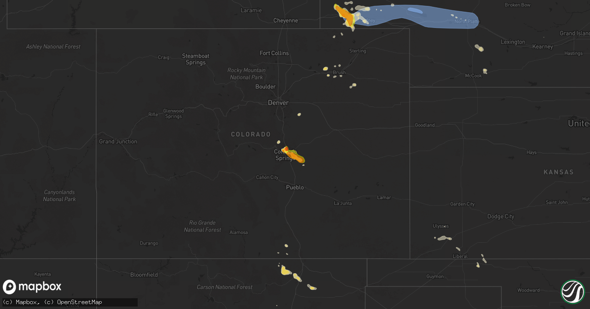
Hail Map on June 15, 2025
Get this storm
June 15 map
$229
one time, instant access
Download today. No call, no setup
Keep the $229
Bought the map and want the full workflow? Apply the entire $229 to a subscription within 7 days. None of it is wasted.
Every map, not just this one
This buys you this map. Subscription and you get every map we run, in the markets you choose from a few cities to whole states to nationwide. Plus real-time alerts the moment a storm fires.
Contact data
Name, contact info, occupancy, even credit band for addresses in the footprint. You go from where it hit to who to call.
Become the source they trust
Unlimited branding weather history reports on demand. You already have the documented answer ready for the property owner, and you are the one who showed up with it.
Property data and RoofTrace estimates
Pull up any address you have got, its value and the exact code rules for that jurisdiction, straight from One Click Code. Then RoofTrace estimates the squares, pitch, and roof value, priced the way you price.
States Impacted by Hail Map on June 15, 2025
Storm reports
South Dakota
| Date | Description |
|---|---|
| 06/15/20257:06 AM CDT | Mesonet station grrs2 bullhead 10 s. |
| 06/15/20255:00 AM CDT | A local report indicates 1.00 inch wind near Pickerel Lake Station |
| 06/15/20254:00 AM CDT | Photos of damaged corn crop. Time estimated via radar. |
| 06/15/20253:41 AM CDT | Mesonet stat |
| 06/15/20253:41 AM CDT | Mesonet station 47 brandt |
| 06/15/20253:25 AM CDT | Asos station kmbg mobridge muni ap. |
| 06/15/20253:25 AM CDT | Asos station kmbg mobridge muni ap. |
| 06/15/20252:58 AM CDT | Mesonet station grrs2 bullhead 10 s. Time estimated based on radar. |
| 06/15/20252:56 AM CDT | Mesonet station 178 trail city |
| 06/15/20252:55 AM CDT | A local report indicates 76 MPH wind near 14 WNW Lodgepole |
| 06/15/20252:50 AM CDT | A local report indicates 84 MPH wind near 7 NNE Ralph |
| 06/15/20252:45 AM CDT | A local report indicates 67 MPH wind near 7 NNE Ralph |
| 06/15/20252:45 AM CDT | A local report indicates 61 MPH wind near Wewela |
| 06/15/20252:40 AM CDT | Mesonet station tims2 timber lake |
| 06/15/20252:40 AM CDT | Mesonet station 293 timber lake |
| 06/15/20252:35 AM CDT | A local report indicates 58 MPH wind near 7 NNE Ralph |
| 06/15/20252:30 AM CDT | Mesonet station 50 herreid |
| 06/15/20252:25 AM CDT | A local report indicates 70 MPH wind near 1 ESE Ladner |
| 06/15/20252:25 AM CDT | A local report indicates 58 MPH wind near 14 E Glad Valley |
| 06/15/20252:20 AM CDT | A local report indicates 74 MPH wind near 4 N Ludlow |
| 06/15/20252:15 AM CDT | A local report indicates 68 MPH wind near 4 N Ludlow |
| 06/15/20252:14 AM CDT | Winds reported to gust over 60 mph and had wind driven small hail. |
| 06/15/20252:10 AM CDT | A local report indicates 70 MPH wind near 1 ESE Ladner |
| 06/15/20252:08 AM CDT | A local report indicates 63 MPH wind near 7 S Shadehill |
| 06/15/20252:05 AM CDT | A local report indicates 58 MPH wind near 4 SSE Witten |
| 06/15/20252:05 AM CDT | A local report indicates 61 MPH wind near 1 ESE Ladner |
| 06/15/20251:10 AM CDT | A local report indicates 65 MPH wind near 14 WNW Lodgepole |
| 06/15/20251:05 AM CDT | A local report indicates 74 MPH wind near 7 NNE Ralph |
| 06/15/20251:00 AM CDT | A local report indicates 58 MPH wind near 14 WNW Lodgepole |
| 06/15/202512:45 AM CDT | A local report indicates 63 MPH wind near 9 ENE Belvidere |
| 06/15/202512:45 AM CDT | A local report indicates 75 MPH wind near 1 NE Midland |
| 06/15/202512:40 AM CDT | A local report indicates 70 MPH wind near 4 N Ludlow |
| 06/15/202512:30 AM CDT | A local report indicates 61 MPH wind near 1 NE Midland |
| 06/15/202512:27 AM CDT | A local report indicates 63 MPH wind near 1 ESE Ladner |
| 06/15/202512:25 AM CDT | A local report indicates 58 MPH wind near 1 NE Midland |
| 06/14/202511:58 PM CDT | A local report indicates 59 MPH wind near 15 SSE Mission |
| 06/14/202511:41 PM CDT | A local report indicates 60 MPH wind near Martin |
| 06/14/202511:28 PM CDT | A local report indicates 62 MPH wind near 6 W Parmelee |
| 06/14/202511:28 PM CDT | A local report indicates 70 MPH wind near 7 E Wanblee |
| 06/14/202511:23 PM CDT | (unr |
| 06/14/202511:23 PM CDT | A local report indicates 60 MPH wind near 4 E Cactus Flat |
| 06/14/202511:15 PM CDT | A local report indicates 60 MPH wind near 8 SE Interior |
| 06/14/202511:13 PM CDT | A local report indicates 69 MPH wind near 4 E Cactus Flat |
| 06/14/202511:00 PM CDT | A local report indicates 64 MPH wind near 2 E Cottonwood |
| 06/14/202510:57 PM CDT | A local report indicates 80 MPH wind near 6 W Cottonwood |
| 06/14/202510:50 PM CDT | A local report indicates 62 MPH wind near 5 NE Porcupine |
| 06/14/202510:45 PM CDT | A local report indicates 65 MPH wind near Wasta |
| 06/14/202510:38 PM CDT | A local report indicates 66 MPH wind near 3 NW Wasta |
| 06/14/202510:35 PM CDT | A local report indicates 63 MPH wind near Wasta |
| 06/14/202510:35 PM CDT | A local report indicates 60 MPH wind near Kyle |
| 06/14/202510:29 PM CDT | A local report indicates 60 MPH wind near Oglala |
| 06/14/202510:25 PM CDT | A local report indicates 60 MPH wind near 6 ESE Scenic |
| 06/14/202510:22 PM CDT | A local report indicates 60 MPH wind near 7 SSW Oglala |
| 06/14/20259:56 PM CDT | A local report indicates 62 MPH wind near 3 E Dwtn Rapid City |
| 06/14/20259:56 PM CDT | A local report indicates 60 MPH wind near 2 NE Swett |
| 06/14/20259:54 PM CDT | A local report indicates 62 MPH wind near 1 E Dwtn Rapid City |
| 06/14/20259:50 PM CDT | A local report indicates 62 MPH wind near 7 SSW Folsom |
| 06/14/20259:50 PM CDT | A local report indicates 64 MPH wind near 1 WNW Caputa |
| 06/14/20259:50 PM CDT | A local report indicates 65 MPH wind near 4 S Dwtn Rapid City |
| 06/14/20259:43 PM CDT | A local report indicates 60 MPH wind near 7 SW Rapid City Arpt |
| 06/14/20259:43 PM CDT | A local report indicates 58 MPH wind near Pringle |
| 06/14/20259:43 PM CDT | A local report indicates 58 MPH wind near 2 ENE Rockerville |
| 06/14/20259:40 PM CDT | A local report indicates 63 MPH wind near 4 S Dwtn Rapid City |
| 06/14/20259:40 PM CDT | A local report indicates 59 MPH wind near 14 NNW Edgemont |
| 06/14/20259:39 PM CDT | A local report indicates 63 MPH wind near 4 S Dwtn Rapid City |
| 06/14/20259:23 PM CDT | A local report indicates 60 MPH wind near 2 ENE Rockerville |
| 06/14/20259:10 PM CDT | A local report indicates 60 MPH wind near Hill City |
| 06/14/20259:03 PM CDT | A local report indicates 1.50 inch wind near 3 W Vale |
| 06/14/20259:01 PM CDT | A local report indicates 1.00 inch wind near 3 W Vale |
| 06/14/20259:00 PM CDT | A local report indicates 60 MPH wind near Hill City |
| 06/14/20258:46 PM CDT | A local report indicates 1.00 inch wind near 3 E Saint Onge |
| 06/14/20258:45 PM CDT | Quarter to ping pong |
| 06/14/20258:15 PM CDT | A local report indicates 1.00 inch wind near 6 SSW Lead |
North Dakota
| Date | Description |
|---|---|
| 06/15/20256:30 AM CDT | Public relayed through broadcast media of 1 inch hail at lewis |
| 06/15/20256:30 AM CDT | Public relayed through broadcast media of 1 inch hail at lewis & clark elementary school near university & i-94. |
| 06/15/20256:20 AM CDT | South university & i-94 with pic |
| 06/15/20256:20 AM CDT | South university & i-94 with picture. |
| 06/15/20256:19 AM CDT | University & 32nd ave s with picture. |
| 06/15/20256:08 AM CDT | A local report indicates 1.00 inch wind near West Fargo |
| 06/15/20253:44 AM CDT | 5 w wishek ndawn. 10 meter peak wind gust. |
| 06/15/20252:40 AM CDT | Tatanka prairie raws. Time estimated from radar. |
| 06/15/20252:15 AM CDT | Williams lookout raws. Delayed report with time estimated from radar. |
| 06/15/20252:15 AM CDT | Report relayed via social media. |
| 06/15/20252:00 AM CDT | 2 e pretty rock ndawn. 10 meter peak wind gust. |
| 06/15/20251:59 AM CDT | 2e pretty rock ndawn. 10 meter peak wind gust. |
| 06/15/20251:22 AM CDT | Multiple grain bins knocked over. Radar estimated time. |
| 06/15/20251:15 AM CDT | Nw hettinger ndawn. 10 meter peak wind gust. |
| 06/15/20251:04 AM CDT | 3w cedar lake ndawn. 10 meter peak wind. |
| 06/15/20251:02 AM CDT | Two shops were destroyed. Radar estimated time. |
| 06/14/202511:49 PM CDT | Williston airport asos. |
| 06/14/20258:48 PM CDT | Nickel to quarter size hail and strong winds. One broken window and a dented vehicle. |
| 06/14/20258:01 PM CDT | Estimates winds up to 60 mph with nickel to slightly larger size hail after strong winds. |
| 06/14/20257:15 PM CDT | Reports hail while driving north northwest of fortuna near the historical airforce station. Also sent photo via social media. |
Colorado
| Date | Description |
|---|---|
| 06/14/20258:32 PM CDT | Report from mping: ping pong ball |
| 06/14/20258:30 PM CDT | Report from mping: half dollar |
| 06/14/20258:27 PM CDT | Report from mping: quarter |
| 06/14/20258:20 PM CDT | Report from mping: quarter |
| 06/14/20257:54 PM CDT | A local report indicates 1.25 inch wind near 4 SE Peterson AFB |
| 06/14/20257:52 PM CDT | A local report indicates 1.25 inch wind near 3 SW Peterson AFB |
| 06/14/20257:48 PM CDT | Report from mping: golf ball |
| 06/14/20257:47 PM CDT | Report from mping: quarter |
| 06/14/20257:45 PM CDT | Report from mping: half dollar |
| 06/14/20257:44 PM CDT | Report from mping: ping pong ball |
| 06/14/20257:43 PM CDT | Report from mping: quarter |
| 06/14/20257:43 PM CDT | A local report indicates 1.50 inch wind near 2 WSW Peterson AFB |
| 06/14/20257:41 PM CDT | Report from mping: quarter |
| 06/14/20257:40 PM CDT | Picture with measurement on social media. |
| 06/14/20257:40 PM CDT | Report from mping: quarter |
| 06/14/20257:35 PM CDT | A local report indicates 1.00 inch wind near 6 NNE Colorado Springs |
| 06/14/20257:34 PM CDT | Report from mping: quarter |
| 06/14/20257:30 PM CDT | Report from storm spotter network. |
| 06/14/20257:19 PM CDT | Report from mping: quarter |
| 06/14/20257:18 PM CDT | A local report indicates 1.00 inch wind near 5 NE Manitou Springs |
Montana
| Date | Description |
|---|---|
| 06/15/20256:57 PM CDT | Report from mping: quarter |
| 06/15/20256:25 PM CDT | Time estimated based on radar. |
| 06/15/20256:05 PM CDT | Report on social media showed golf ball sized hail with estimated 60 mph wind gusts. Time estimated based on radar. |
| 06/15/20255:48 PM CDT | Trained spotter reports egg to tennis ball size hail. Images were provided. |
| 06/15/20255:30 PM CDT | Report from social media. Hail started at 4:30 pm and lasted for approximately 15 minutes. |
| 06/15/20255:30 PM CDT | Social media image of approximately golf ball sized hail in highwood. Time estimated using radar. |
| 06/15/20255:10 PM CDT | Trained spotter reports quarter size to slightly larger than quarter size hail. |
| 06/15/20255:10 PM CDT | Trained spotter reports quarter size to slightly larger than q |
| 06/15/20255:10 PM CDT | Quarter size hail reported. |
| 06/15/20255:06 PM CDT | Social media report of 1 inch hail. Time and location estimated. |
| 06/15/20255:05 PM CDT | Social media report of three quarter of an inch to an inch sized hail. |
| 06/15/20255:01 PM CDT | Social media report of one inch diameter hail in fort benton. |
| 06/15/20255:00 PM CDT | Quarter size hail reported. |
| 06/15/20255:00 PM CDT | Trained spotter reports quarter size hail along with 30 to 50 mph winds along highway 87 north of the republic services landfill and south of dent bridge road. |
| 06/15/20255:00 PM CDT | Public report with image of quarter sized hail next to a quarter for reference. |
| 06/15/20255:00 PM CDT | Public report with image of ping pong sized hail near north middle school. |
| 06/15/20254:55 PM CDT | Ambient weather station. |
| 06/15/20254:40 PM CDT | Quarter size hail reported. Damage to vehicles and rv reported as well. |
| 06/15/20254:25 PM CDT | Quarter size hail reported by member of the public. |
| 06/15/20254:24 PM CDT | Report from mping: quarter |
| 06/15/20253:20 PM CDT | Trained spotter reports hail of quarter size to half dollar size along us-87 between moccasin and windham. Damage to automobiles reported as well. |
| 06/15/20253:10 PM CDT | Public caller updated with golf ball sized hail a few minutes after initial call. |
| 06/15/20253:05 PM CDT | Public report of quarter sized hail around benchland. |
| 06/15/20251:54 AM CDT | A local report indicates 77 MPH wind near 7 SE Ekalaka |
| 06/15/20251:30 AM CDT | A local report indicates 71 MPH wind near 4 NE Medicine Rocks Sta |
| 06/15/20251:15 AM CDT | Mesonet station mteka baker mt-7 mp 14.2. |
| 06/15/20251:00 AM CDT | Ash creek mt dot |
| 06/14/202511:16 PM CDT | Bloomfield... Mt |
| 06/14/202511:12 PM CDT | A local report indicates 81 MPH wind near 3 WNW Miles City |
| 06/14/202510:50 PM CDT | A local report indicates 58 MPH wind near 2 NW Rock Springs |
| 06/14/202510:45 PM CDT | Badger creek (aprswxnet/c |
| 06/14/202510:45 PM CDT | Badger creek |
| 06/14/202510:40 PM CDT | Corrects previous tstm wnd gst report from 10 w homestead. Public reported on facebook... And 0.5 inches of rain. |
| 06/14/202510:40 PM CDT | A local report indicates 60 MPH wind near 10 SSE Bighorn |
| 06/14/202510:35 PM CDT | Awos station k00u 2 wnw hardin. |
| 06/14/202510:20 PM CDT | Poplar raws station. Time estimated by radar. |
| 06/14/202510:18 PM CDT | Glasgow sw |
| 06/14/202510:18 PM CDT | Glasgow |
| 06/14/202510:00 PM CDT | Wolf point nw |
| 06/14/202510:00 PM CDT | Mesonet station mtm89 angela w. |
| 06/14/20259:52 PM CDT | Fort peck dam station. |
| 06/14/20259:50 PM CDT | Bredette ne |
| 06/14/20259:00 PM CDT | Nashua ne |
| 06/14/20258:50 PM CDT | Mosby se |
| 06/14/20258:42 PM CDT | Hail sized noted by staff at nws glasgow mt. |
| 06/14/20258:42 PM CDT | Asos reported 71 mph wind gust. |
| 06/14/20258:30 PM CDT | A local report indicates 1.00 inch wind near 1 NW Glasgow |
| 06/14/20258:20 PM CDT | A local report indicates 1.00 inch wind near 11 NNW Roundup |
| 06/14/20258:01 PM CDT | Large hail about 3.5 inches... Lasting for about 15 mins. |
| 06/14/20258:00 PM CDT | A storm chaser on x measured multiple hail stones of 2.5 inches in diameter with a ruler. |
| 06/14/20257:52 PM CDT | Broken windows and damage to vehicles. |
| 06/14/20257:50 PM CDT | Montana mesonet near saco. |
| 06/14/20257:45 PM CDT | A local report indicates 1.75 inch wind near 5 E Winnet |
| 06/14/20257:40 PM CDT | Trained spotter reports quarter size hail. |
| 06/14/20257:39 PM CDT | Hail up to the size of golf balls with winds 30-40 mph. |
| 06/14/20257:19 PM CDT | Report from spotter network. |
| 06/14/20257:14 PM CDT | Report from mping: ping pong ball |
| 06/14/20257:00 PM CDT | Hail ranging from pea size to half dollar size fell for about 5 minutes. |
| 06/14/20257:00 PM CDT | Spotter reported pea sized hail... Heavy rain... And winds winds 50 to 60 mph estimated. |
Florida
| Date | Description |
|---|---|
| 06/15/202511:48 AM CDT | Downed power line resulted in the closure of ne 16th ave. |
Missouri
| Date | Description |
|---|---|
| 06/14/20257:26 PM CDT | About a half dozen trees down along highway j south of fremont. |
Virginia
| Date | Description |
|---|---|
| 06/15/20255:32 PM CDT | Trained spotter reported |
| 06/15/20255:32 PM CDT | Trained spotter reported 1 inch hail. |
| 06/15/20255:05 PM CDT | Tree fell across poor house rd. |
| 06/15/20254:37 PM CDT | Large limb dow |
| 06/15/20254:37 PM CDT | Corrects previous tstm wnd dmg report from 3 sse golansville. Large limb down blocking a portion of telegraph road. Time estimated from radar. |
| 06/15/20254:37 PM CDT | Large limb down blocking a portion of telegraph road. Time estimated from radar. |
| 06/15/20254:16 PM CDT | A brick chimney was knocked down due to strong wind gusts. Time estimated from radar. |
| 06/15/20254:00 PM CDT | Large limb across power line. |
| 06/15/20253:32 PM CDT | Tree down across highway |
| 06/15/20253:25 PM CDT | Tree across powerline. Power is out. |
| 06/15/20253:05 PM CDT | Large branches down in street. |
| 06/15/20252:55 PM CDT | Thunderstorm winds blew down one tree that fell on to a power line along the 2000 block of pointer road. |
| 06/15/20251:54 PM CDT | Thunderstorm winds blew down one tree limb that knocked down a telephone line along the 400 block of moses mill road. |
| 06/15/20251:36 PM CDT | Thunderstorm winds blew down one tree along the 3000 block of burnt chimney road. |
| 06/15/20251:13 PM CDT | Thunderstorm winds blew down one tree down along the 2400 block of booker t washington highway. |
| 06/15/20251:11 PM CDT | Thunderstorm winds blew down one tree along the 2300 block of henry road across from a church. |
| 06/15/202512:35 PM CDT | Thunderstorm winds blew down a tree and a power pole along the 100 block of little mountain circle. |
Iowa
| Date | Description |
|---|---|
| 06/14/20258:55 PM CDT | Largest hail to ping pong ball sized. |
Wyoming
| Date | Description |
|---|---|
| 06/14/20258:10 PM CDT | Nickel to quarter |
| 06/14/20257:12 PM CDT | A local report indicates 67 MPH wind near 25 ESE Wright |
| 06/14/20257:08 PM CDT | A local report indicates 1.00 inch wind near 7 NNW Dwtn Gillette |
North Carolina
| Date | Description |
|---|---|
| 06/15/20256:50 PM CDT | Multiple trees down in scotland neck. |
| 06/15/20256:00 PM CDT | Trees down. |
| 06/14/20258:38 PM CDT | Powerlines down along beaumont drive due to a tree down. |
New Mexico
| Date | Description |
|---|---|
| 06/15/20256:35 PM CDT | A trained spotter along nm 294 south of taiban observed a few golf ball sized hail among lots of pea size hail. |
| 06/15/20255:53 PM CDT | Asos station kcnm carlsbad. |
| 06/15/20254:15 PM CDT | Awos station kats artesia. |
| 06/15/20254:14 PM CDT | Outflow winds from nearby thunderstorms resulted in a 67 mph gust at the roswell air center. |
| 06/14/20258:45 PM CDT | The asos at raton crew airport observed a wind gust of 68 mph from nearby thunderstorms. |
| 06/14/20258:45 PM CDT | The asos at raton crew airport observed a wind gust of 68 mph from ne |
| 06/14/20258:30 PM CDT | The melrose range mesonet station observed a 70 mph wind gust from nearby collapsing thunderstorms. |
| 06/14/20257:00 PM CDT | A trained spotter along u.s. 60 and 84 a few miles east of taiban observed nickel to quarter size hail from a severe thunderstorm. |
Texas
| Date | Description |
|---|---|
| 06/15/202511:25 AM CDT | Billboard completely destroyed and wrapped around a telephone pole. |
| 06/15/202511:16 AM CDT | Hangar door blown off track at freeman jet center-abilene regional airport. |
| 06/15/202511:13 AM CDT | Asos station kabi abilene. |
| 06/15/202511:12 AM CDT | Metal roof blown off a small building across from the abilene livestock auction. |
| 06/15/202510:09 AM CDT | Mesonet station 102 5ese stamford stamford/jones county. |
| 06/15/20259:27 AM CDT | Knox city |
| 06/15/20259:23 AM CDT | Hefner mesonet. Multiple severe wind gusts between 9 |
| 06/15/20259:23 AM CDT | Hefner |
| 06/15/20258:01 AM CDT | Odell |
| 06/15/20254:00 AM CDT | Off-duty broadcast meteorologist saw part of a wooden fence knocked over on the corner of n washam dr and cimarron blvd. Time estimated from radar. |
| 06/15/20254:00 AM CDT | Off-duty broadcast meteorologist reported that a large tree branch fell on sidewalk/partially into the road along cimarron blvd... Just past dunbarton oak st |
| 06/14/20258:26 PM CDT | Reports of a tree blocking the road. |
| 06/14/20258:10 PM CDT | Tree blown down onto roadway. |
| 06/14/20257:56 PM CDT | Trees down reported in the city. |
Nebraska
| Date | Description |
|---|---|
| 06/15/20256:34 PM CDT | Kbff reported 61mph gust. |
| 06/14/202510:43 PM CDT | Klbf asos. |
| 06/14/20259:27 PM CDT | A local report indicates 64 MPH wind near 4 SE Ogallala |
| 06/14/20259:18 PM CDT | Anemometer measured 62mph wind gust. |
| 06/14/20259:18 PM CDT | A local report indicates 68 MPH wind near Ogallala |
| 06/14/20259:16 PM CDT | Koga awos. |
| 06/14/20259:12 PM CDT | A local report indicates 74 MPH wind near 1 SW Lemoyne |
| 06/14/20258:43 PM CDT | A local report indicates 60 MPH wind near 5 ESE Oshkosh |
| 06/14/20258:10 PM CDT | Ksny reported 58mph gust. |
| 06/14/20257:51 PM CDT | Emergency manager estimated gusts of 60mph. |
| 06/14/20257:35 PM CDT | Mesonet near brownson reported a 62mph gust. |
| 06/14/20257:34 PM CDT | Storm chaser estimating 60mph winds with half in hail. |
| 06/14/20257:27 PM CDT | A local report indicates 1.00 inch wind near 9 SSE Merriman |
| 06/14/20257:04 PM CDT | Report from mping. |
| 06/14/20257:01 PM CDT | Storm chaser reporting ping pong ball sized hail ongoing in dix. |
Oklahoma
| Date | Description |
|---|---|
| 06/15/20257:53 AM CDT | Section of a metal and wood barn blown off. Social media image. Event time estimated from radar. |
| 06/15/20257:38 AM CDT | Klts. |
Cities Impacted by Hail Map on June 15, 2025
- Terry, MT
- Brockway, MT
- Mclean, TX
- Wellington, TX
- Burbank, SD
- Vermillion, SD
- Centerville, SD
- Roy, MT
- Beresford, SD
- Quail, TX
- Mangum, OK
- Johnson, KS
- Alcester, SD
- Cohagen, MT
- Ulysses, KS
- Altus, OK
- Olustee, OK
- Blair, OK
- Headrick, OK
- Altus Afb, OK
- Hedley, TX
- Lelia Lake, TX
- Eldorado, OK
- Sand Springs, MT
- Moscow, KS
- Hudson, SD
- Hugoton, KS
- Tipton, OK
- Elmer, OK
- Frederick, OK
- Vernon, TX
- Odell, TX
- Quanah, TX
- Hawarden, IA
- Chillicothe, TX
- Davidson, OK
- Oklaunion, TX
- Harrold, TX
- Ireton, IA
- Liberal, KS
- Le Mars, IA
- Akron, IA
- Forestburg, TX
- Sunset, TX
- Paducah, TX
- Forgan, OK
- Miller, SD
- Shamrock, TX
- Saint Lawrence, SD
- Meade, KS
- Ashton, IA
- Seymour, TX
- Benjamin, TX
- Knox City, TX
- Munday, TX
- O'Brien, TX
- Crowell, TX
- Holliday, TX
- Goree, TX
- Scotland, TX
- Archer City, TX
- Electra, TX
- Weinert, TX
- Iowa Park, TX
- Wichita Falls, TX
- Newcastle, TX
- Haskell, TX
- Rochester, TX
- Graham, TX
- Olney, TX
- Throckmorton, TX
- Loving, TX
- Windthorst, TX
- Woodson, TX
- Wessington, SD
- Memphis, TX
- Breckenridge, TX
- Albany, TX
- South Bend, TX
- Caddo, TX
- Wessington Springs, SD
- Moran, TX
- Wolsey, SD
- Huron, SD
- Baird, TX
- Cisco, TX
- Clyde, TX
- Abilene, TX
- Tuscola, TX
- Buffalo Gap, TX
- Cross Plains, TX
- Ovalo, TX
- Lawn, TX
- Willow Lake, SD
- Clark, SD
- Carpenter, SD
- Yale, SD
- Goldsboro, TX
- Burkett, TX
- Coleman, TX
- Garretson, SD
- Novice, TX
- Winters, TX
- Talpa, TX
- Santa Anna, TX
- Vienna, SD
- Hazel, SD
- Bryant, SD
- Jasper, MN
- Henry, SD
- Gustine, TX
- Whitney, TX
- Holden, LA
- Aquilla, TX
- Webster, SD
- Roslyn, SD
- Leesville, LA
- McGregor, TX
- Eden, SD
- Fort Hood, TX
- Temple, TX
- Nolanville, TX
- Belton, TX
- Woodbine, GA
- Hobson, MT
- Plantersville, TX
- Navasota, TX
- Gainesville, MO
- Georgetown, TX
- Splendora, TX
- Cleveland, TX
- Florence, TX
- New Caney, TX
- Llano, TX
- Kingsland, TX
- Porter, TX
- Spring, TX
- Smithville, TX
- Lake Park, GA
- Statenville, GA
- Horseshoe Bay, TX
- Conroe, TX
- Moore, MT
- Stanford, MT
- Rockdale, TX
- Weston, CO
- Brookings, SD
- Lexington, TX
- Caldwell, TX
- Bryan, TX
- Mayhill, NM
- Paige, TX
- Hearne, TX
- Houston, TX
- North Zulch, TX
- Normangee, TX
- Denton, MT
- Fort Benton, MT
- Boykins, VA
- Tinnie, NM
- Aurora, SD
- Branchville, VA
- Dime Box, TX
- Newsoms, VA
- Lincoln, TX
- Moccasin, MT
- Smiley, TX
- Loma, MT
- Wrightsboro, TX
- Interlachen, FL
- Gonzales, TX
- Flatonia, TX
- La Grange, TX
- Springfield, GA
- Muldoon, TX
- West Point, TX
- Wimberley, TX
- Spring Branch, TX
- Pomona, MO
- Grapeland, TX
- Canyon Lake, TX
- Blanco, TX
- Slayton, MN
- Roswell, NM
- Fairfield, MT
- Melrose, FL
- Crockett, TX
- Richmond, VA
- Artesia, NM
- Fort Shaw, MT
- Sun River, MT
- Vaughn, MT
- Florahome, FL
- West Plains, MO
- Alto, TX
- Sanborn, IA
- Paullina, IA
- Chunchula, AL
- Power, MT
- Carlsbad, NM
- Great Falls, MT
- Corona, NM
- Mountain View, MO
- Patterson, GA
- Hortense, GA
- Nahunta, GA
- Clayton, NC
- Hagerman, NM
- Black Eagle, MT
- Floweree, MT
- Birch Tree, MO
- Elizabeth, CO
- Clarion, IA
- Highwood, MT
- Wilmont, MN
- Lismore, MN
- Creston, IA
- Hartley, IA
- Freeman, VA
- Emporia, VA
- Lawrenceville, VA
- Jbsa Randolph, TX
- Converse, TX
- Kiowa, CO
- Cibolo, TX
- Richton, MS
- Fischer, TX
- Ocheyedan, IA
- Bulverde, TX
- State Line, MS
- Akron, CO
- Lockhart, TX
- New Braunfels, TX
- Geyser, MT
- Luling, TX
- Orient, IA
- Capitan, NM
- Jarratt, VA
- White Sulphur Springs, MT
- Melvin, IA
- Merriman, NE
- Remsen, IA
- Kingsley, IA
- Geraldine, MT
- Dows, IA
- Stockett, MT
- San Antonio, TX
- Big Sandy, MT
- Pearsall, TX
- Helotes, TX
- Lewistown, MT
- Fort Morgan, CO
- Marcus, IA
- Fort Sumner, NM
- Brush, CO
- Worthington, MN
- Vaughn, NM
- Louisburg, NC
- Spring Hope, NC
- Alden, IA
- Cody, NE
- Rocky Mount, NC
- Elm City, NC
- Pinetops, NC
- Millry, AL
- Chatom, AL
- Pipestone, MN
- Weldona, CO
- Harris, IA
- Whitakers, NC
- Tarboro, NC
- Battleboro, NC
- Castalia, NC
- Coffee Creek, MT
- Arcadia, FL
- Charlotte, TX
- Jourdanton, TX
- Frankville, AL
- Springer, NM
- Taiban, NM
- Enfield, NC
- Jackson, AL
- Okabena, MN
- Lakefield, MN
- Brewster, MN
- Dodson, MT
- Lake Park, IA
- Bigfoot, TX
- Malta, MT
- Forest Grove, MT
- Grass Range, MT
- Grove Hill, AL
- Wilsall, MT
- Savannah, GA
- Moore, TX
- Kimball, NE
- Elida, NM
- Livingston, MT
- Bozeman, MT
- Colorado Springs, CO
- Harrisburg, NE
- Dix, NE
- Snyder, CO
- Buffalo, MT
- Two Dot, MT
- Fortuna, ND
- Ledyard, IA
- Swea City, IA
- Lenox, IA
- Glenrock, WY
- Camden, NC
- Potter, NE
- Gillette, WY
- Cotulla, TX
- Scotland Neck, NC
- Sidney, NE
- Floyd, NM
- Melrose, NM
- Usaf Academy, CO
- Madrid, IA
- Woodward, IA
- Ambrose, ND
- Clearfield, IA
- Gurley, NE
- Diagonal, IA
- Crosby, ND
- Dalton, NE
- Winnett, MT
- Raton, NM
- Peetz, CO
- Bayard, NE
- Bedford, IA
- Richmond Hill, GA
- Peyton, CO
- Hinsdale, MT
- Judith Gap, MT
- Saco, MT
- Lovell, WY
- Cowley, WY
- Whatley, AL
- Armstrong, IA
- Beeville, TX
- Fort Peck, MT
- Hilger, MT
- Clovis, NM
- Mosby, MT
- Brusett, MT
- Calhan, CO
- Hulett, WY
- Devils Tower, WY
- Moorcroft, WY
- Fairmont, MN
- Blockton, IA
- Noonan, ND
- Columbus, ND
- Lead, SD
- Deadwood, SD
- Spearfish, SD
- Whitewood, SD
- Ryegate, MT
- Batesland, SD
- Lavina, MT
- Glasgow, MT
- Martin, SD
- Greenfield, IA
- Porcupine, SD
- Allen, SD
- McLeod, MT
- Griswold, IA
- Greenville, NC
- Redfield, IA
- Earlham, IA
- Nashua, MT
- Vandalia, MT
- Saint Marie, MT
- Vale, SD
- Nisland, SD
- Wounded Knee, SD
- Martinsdale, MT
- Red Oak, IA
- Elliott, IA
- Lewis, IA
- Sturgis, SD
- Marne, IA
- Atlantic, IA
- Clarinda, IA
- Nodaway, IA
- Corning, IA
- Adel, IA
- New Raymer, CO
- Lodgepole, NE
- Padroni, CO
- Roberts, MT
- Newell, SD
- Oshkosh, NE
- Roundup, MT
- Chappell, NE
- Lewellen, NE
- Lisco, NE
- Big Springs, NE
- Brule, NE
- Ogallala, NE
- Keystone, NE
- Lemoyne, NE
- Arthur, NE
- Wolf Point, MT
- Frazer, MT
- Forsyth, MT
- Granger, IA
- Wanblee, SD
- Big Timber, MT
- Poplar, MT
- New Underwood, SD
- Oelrichs, SD
- Nye, MT
- Absarokee, MT
- Hermosa, SD
- Scenic, SD
- Angela, MT
- Hardin, MT
- Owanka, SD
- Hays, MT
- Pine Ridge, SD
- Heber Springs, AR
- Fishtail, MT
- Caputa, SD
- Pompeys Pillar, MT
- Lodge Grass, MT
- Kyle, SD
- Hershey, NE
- Manderson, SD
- Wall, SD
- Wasta, SD
- Paxton, NE
- Brockton, MT
- Westby, MT
- Roscoe, MT
- Red Lodge, MT
- Vredenburgh, AL
- Oglala, SD
- Plentywood, MT
- Mullen, NE
- Otter, MT
- Homestead, MT
- Medicine Lake, MT
- Bighorn, MT
- Tryon, NE
- North Platte, NE
- Crow Agency, MT
- Busby, MT
- Birney, MT
- Miles City, MT
- Kinsey, MT
- Decker, MT
- Valentine, NE
- Conchas Dam, NM
- Sutherland, NE
- Maxwell, NE
- Lambert, MT
- Fairview, MT
- Culbertson, MT
- Froid, MT
- Kadoka, SD
- Interior, SD
- Philip, SD
- Quinn, SD
- Ballantine, MT
- Worden, MT
- Rosebud, MT
- Volborg, MT
- Newkirk, NM
- Lame Deer, MT
- Stapleton, NE
- Ismay, MT
- Cherry Creek, SD
- Curtis, NE
- Maywood, NE
- Colstrip, MT
- Cartwright, ND
- Moorefield, NE
- Indianola, NE
- Bartley, NE
- Buffalo, SD
- Bowman, ND
- Camp Crook, SD
- Meadow, SD
- Rhame, ND
- Ludlow, SD
- Alzada, MT
- Lemmon, SD
- New England, ND
- Timber Lake, SD
- Scranton, ND
- Glencross, SD
- Dupree, SD
- Trail City, SD
- McIntosh, SD
- Ralph, SD
- Reva, SD
- Reeder, ND
- Wakpala, SD
- Lodgepole, SD
- Amidon, ND
- Prairie City, SD
- Hettinger, ND
- Regent, ND
- McLaughlin, SD
- Selfridge, ND
- Keldron, SD
- Watford City, ND
- Agar, SD
- New Leipzig, ND
- Watauga, SD
- Mound City, SD
- Mott, ND
- Bison, SD
- Elgin, ND
- Eureka, SD
- Carson, ND
- Shields, ND
- Pollock, SD
- Herreid, SD
- Solen, ND
- Highmore, SD
- Raleigh, ND
- Fort Yates, ND
- Flasher, ND
- Ashley, ND
- Zeeland, ND
- Hague, ND
- Strasburg, ND
- Linton, ND
- Hazelton, ND
- Wishek, ND
- Mandan, ND
- Cannon Ball, ND
- Bancroft, IA
- Walker, SD
- Morristown, SD
- Saint Anthony, ND
- Ipswich, SD
- Roscoe, SD
- Kintyre, ND
- Saint Onge, SD
- Braddock, ND
- Bruce, SD
- Moffit, ND
- Estelline, SD
- Toronto, SD
- Napoleon, ND
- Saint James, MN
- Steele, ND
- Lehr, ND
- Clear Lake, SD
- Dawson, ND
- Westport, SD
- Edgeley, ND
- Kulm, ND
- Fredonia, ND
- Tappen, ND
- Streeter, ND
- Turton, SD
- Gackle, ND
- Conde, SD
- Raymond, SD
- Frederick, SD
- Minnesota Lake, MN
- Jud, ND
- Ellendale, ND
- Fullerton, ND
- Oakes, ND
- Jamestown, ND
- Montpelier, ND
- Dickey, ND
- Berlin, ND
- Britton, SD
- Waubay, SD
- Grenville, SD
- Lamoure, ND
- Cogswell, ND
- Marion, ND
- Bricelyn, MN
- Blue Earth, MN
- Litchville, ND
- Fort Ransom, ND
- Verona, ND
- Spiritwood, ND
- Havana, ND
- Stirum, ND
- Wells, MN
- Easton, MN
- Forman, ND
- Sanborn, ND
- Peever, SD
- Sisseton, SD
- Lisbon, ND
- Saint Peter, MN
- New Effington, SD
- Tower City, ND
- Milnor, ND
- Kiester, MN
- Hankinson, ND
- Wyndmere, ND
- Alden, MN
- Rosholt, SD
- Fairmount, ND
- Wahpeton, ND
- Wheaton, MN
- West Fargo, ND
- Fargo, ND
- Davenport, ND
- Horace, ND
- Moorhead, MN
- Blooming Prairie, MN
- Sabin, MN
- Rothsay, MN
- Barnesville, MN
- Pelican Rapids, MN
- Mapleton, MN
- Waltham, MN
- Brownsdale, MN
- Delavan, MN
- Austin, MN
- Emmons, MN
- Conger, MN
- Albert Lea, MN
- Hawley, MN