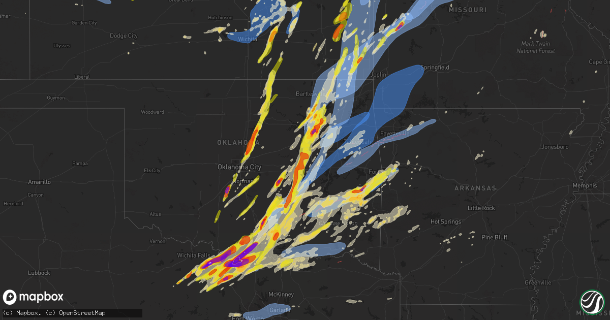
Hail Map on May 19, 2025
Get this storm
May 19 map
$229
one time, instant access
Download today. No call, no setup
Keep the $229
Bought the map and want the full workflow? Apply the entire $229 to a subscription within 7 days. None of it is wasted.
Every map, not just this one
This buys you this map. Subscription and you get every map we run, in the markets you choose from a few cities to whole states to nationwide. Plus real-time alerts the moment a storm fires.
Contact data
Name, contact info, occupancy, even credit band for addresses in the footprint. You go from where it hit to who to call.
Become the source they trust
Unlimited branding weather history reports on demand. You already have the documented answer ready for the property owner, and you are the one who showed up with it.
Property data and RoofTrace estimates
Pull up any address you have got, its value and the exact code rules for that jurisdiction, straight from One Click Code. Then RoofTrace estimates the squares, pitch, and roof value, priced the way you price.
States Impacted by Hail Map on May 19, 2025
Storm reports
Oklahoma
| Date | Description |
|---|---|
| 05/19/20256:50 PM CDT | Measured thunderstorm wind gust of 64 mph at the cookson mesonet. |
| 05/19/20256:50 PM CDT | A local report indicates 82 MPH wind near 4 ENE Cookson |
| 05/19/20256:48 PM CDT | Trained spotter measured thunderstorm wind gust to 64 mph at us highway 60 near intersection with highway 11. |
| 05/19/20256:47 PM CDT | Report from mping: quarter |
| 05/19/20256:46 PM CDT | A local report indicates 1.25 inch wind near 2 W Burbank |
| 05/19/20256:45 PM CDT | Large trees and power lines down near west lakewood drive and white raven road. Time estimated from radar. |
| 05/19/20256:45 PM CDT | Report from mping: half dollar |
| 05/19/20256:44 PM CDT | Tornado debris signature. |
| 05/19/20256:35 PM CDT | Measured thunderstorm wind gust of 58 mph at the wilburton mesonet. |
| 05/19/20256:30 PM CDT | A measured thunderstorm wind gust occurred at the webbers falls mesonet. |
| 05/19/20256:24 PM CDT | Tornado debris signature. |
| 05/19/20256:15 PM CDT | Report from mping: half dollar |
| 05/19/20256:15 PM CDT | Tornado debris signature. |
| 05/19/20255:56 PM CDT | A local report indicates 1.75 inch wind near 4 WSW Stillwater |
| 05/19/20255:53 PM CDT | Thunderstorm wind gust estimated to 60 mph at 428 and 630rd in choteau. |
| 05/19/20255:51 PM CDT | Tornado debris signature. |
| 05/19/20255:49 PM CDT | Nwschat report... Mainly pea sized hail with some golfballs. |
| 05/19/20255:41 PM CDT | A local report indicates 1.00 inch wind near Coyle |
| 05/19/20255:41 PM CDT | Shingles blew off a house. |
| 05/19/20255:37 PM CDT | Report from mping: quarter |
| 05/19/20255:27 PM CDT | A local report indicates 1.25 inch wind near 3 N Meridian |
| 05/19/20255:26 PM CDT | A local report indicates a tornado near 5 WSW Wardville |
| 05/19/20255:21 PM CDT | Reported through mping. |
| 05/19/20255:20 PM CDT | X post with photo. |
| 05/19/20255:18 PM CDT | Photo sent to eoc in edmond. |
| 05/19/20255:15 PM CDT | Trees downed onto powerlines off of mill street in ravia. |
| 05/19/20255:13 PM CDT | Report of trees down in south coffeyville. |
| 05/19/20255:02 PM CDT | A local report indicates 1.00 inch wind near 1 W Forest Park |
| 05/19/20254:58 PM CDT | Tree debris with tree on roadway on cr 1475. Time is radar estimate. |
| 05/19/20254:55 PM CDT | Measured thunderstorm wind gust of 62 mph at the copan mesonet. |
| 05/19/20254:54 PM CDT | Delayed report. Report from mping: quarter |
| 05/19/20254:52 PM CDT | Delayed report. Kokc. |
| 05/19/20254:49 PM CDT | On highway 76 just south of 32. |
| 05/19/20254:49 PM CDT | X photo with measurement. |
| 05/19/20254:48 PM CDT | Tree down in roadway at cr 3 drive and cr3580... Time is radar estimate. |
| 05/19/20254:46 PM CDT | Along highway 3w between stonewall and ahloso. |
| 05/19/20254:45 PM CDT | A local report indicates 1.00 inch wind near Moore |
| 05/19/20254:45 PM CDT | Estimated 55 mph wind gust as well. |
| 05/19/20254:45 PM CDT | A local report indicates 1.00 inch wind near 8 SE Dewey |
| 05/19/20254:40 PM CDT | Measured at ok mesonet site. |
| 05/19/20254:36 PM CDT | Reported on highway 76. |
| 05/19/20254:35 PM CDT | Measured thunderstorm wind gust of 66 mph at the talala mesonet. |
| 05/19/20254:28 PM CDT | A local report indicates 1.00 inch wind near 3 SE Collinsville |
| 05/19/20254:28 PM CDT | Lots of quarter to ping pong hail observed. |
| 05/19/20254:27 PM CDT | A local report indicates 1.75 inch wind near 3 NE Tulsa |
| 05/19/20254:26 PM CDT | Report from mping: ping pong ball |
| 05/19/20254:25 PM CDT | Measured thunderstorm wind gust of 67 mph at the skiatook mesonet. |
| 05/19/20254:23 PM CDT | A local report indicates 1.00 inch wind near Middleberg |
| 05/19/20254:22 PM CDT | A local report indicates 1.00 inch wind near 4 SW Vera |
| 05/19/20254:17 PM CDT | Reported at fire department. |
| 05/19/20254:17 PM CDT | A local report indicates 1.00 inch wind near 2 NW Verdigris |
| 05/19/20254:15 PM CDT | A local report indicates 1.00 inch wind near 5 E Owasso |
| 05/19/20254:13 PM CDT | A local report indicates 1.25 inch wind near 3 E Owasso |
| 05/19/20254:13 PM CDT | Report of golf ball hail and tree limbs down at 31st and yale. |
| 05/19/20254:12 PM CDT | A local report indicates 1.00 inch wind near 1 S Skiatook |
| 05/19/20254:12 PM CDT | Quarter size hail lasting approximately 4 minutes. Leaves ripped off trees. |
| 05/19/20254:12 PM CDT | A local report indicates 1.25 inch wind near 1 E Owasso |
| 05/19/20254:11 PM CDT | A local report indicates 1.50 inch wind near 1 S Skiatook |
| 05/19/20254:11 PM CDT | A local report indicates 1.50 inch wind near 4 W Verdigris |
| 05/19/20254:11 PM CDT | A local report indicates 1.00 inch wind near 3 E Owasso |
| 05/19/20254:10 PM CDT | A local report indicates 1.00 inch wind near 1 N Owasso |
| 05/19/20254:08 PM CDT | National weather service office @ 11th and highway 169. |
| 05/19/20254:06 PM CDT | Reported at lone grove city hall. |
| 05/19/20254:06 PM CDT | A local report indicates 1.25 inch wind near 2 SW Tulsa |
| 05/19/20254:06 PM CDT | Measured thunderstorm wind gust of 64 mph at the tulsa asos. |
| 05/19/20254:05 PM CDT | A local report indicates 1.50 inch wind near 2 N Tulsa |
| 05/19/20254:04 PM CDT | A local report indicates 1.00 inch wind near 4 NE Tulsa |
| 05/19/20254:03 PM CDT | A local report indicates 1.75 inch wind near 4 NW Broken Arrow |
| 05/19/20254:03 PM CDT | A local report indicates 1.00 inch wind near 4 E Tulsa |
| 05/19/20254:02 PM CDT | Large tree and several large limbs down. Time estimated from radar. |
| 05/19/20254:02 PM CDT | A local report indicates 1.25 inch wind near 2 NW Tulsa |
| 05/19/20254:01 PM CDT | A local report indicates 1.50 inch wind near 2 N Tulsa |
| 05/19/20254:01 PM CDT | A local report indicates 1.25 inch wind near 3 W Tulsa |
| 05/19/20254:00 PM CDT | A local report indicates 1.25 inch wind near 2 E Tulsa |
| 05/19/20254:00 PM CDT | A local report indicates 1.50 inch wind near 5 E Tulsa |
| 05/19/20254:00 PM CDT | A local report indicates 1.00 inch wind near 3 E Glenpool |
| 05/19/20254:00 PM CDT | A local report indicates 1.00 inch wind near 3 SW Tulsa |
| 05/19/20253:59 PM CDT | A local report indicates 1.25 inch wind near 3 SW Tulsa |
| 05/19/20253:58 PM CDT | A local report indicates 1.00 inch wind near 4 E Glenpool |
| 05/19/20253:57 PM CDT | A local report indicates 1.00 inch wind near 3 W Jenks |
| 05/19/20253:57 PM CDT | A local report indicates 2.00 inch wind near 2 NE Jenks |
| 05/19/20253:57 PM CDT | A local report indicates 1.75 inch wind near 4 SW Tulsa |
| 05/19/20253:56 PM CDT | Along highway 76 and to the north towards town. |
| 05/19/20253:56 PM CDT | A local report indicates 1.75 inch wind near 2 NE Jenks |
| 05/19/20253:56 PM CDT | A local report indicates 1.00 inch wind near 3 NW Broken Arrow |
| 05/19/20253:55 PM CDT | A local report indicates 1.25 inch wind near Jenks |
| 05/19/20253:55 PM CDT | Numerous large tree limbs down throughout downtown and west sides of sapulpa. Time estimated from radar. |
| 05/19/20253:53 PM CDT | A local report indicates 1.00 inch wind near Jenks |
| 05/19/20253:52 PM CDT | Nickel to quarter size hail at 71st and yale. |
| 05/19/20253:50 PM CDT | A local report indicates 1.00 inch wind near 3 E Jenks |
| 05/19/20253:48 PM CDT | A local report indicates 1.00 inch wind near Mounds |
| 05/19/20253:41 PM CDT | Aw. |
| 05/19/20253:38 PM CDT | Aw. |
| 05/19/20253:29 PM CDT | Photo in nwschat. |
| 05/19/20253:28 PM CDT | Tree down in road. Approximately 8 inch in diameter. |
| 05/19/20253:17 PM CDT | A local report indicates 1.75 inch wind near 1 E Seminole |
| 05/19/20253:13 PM CDT | A local report indicates 1.50 inch wind near Okemah |
| 05/19/20252:56 PM CDT | Spotternetwork report. |
| 05/19/20252:56 PM CDT | Spotternetwork report. |
| 05/19/20252:56 PM CDT | Spotternetwork report. |
| 05/19/20252:37 PM CDT | Report from mping: half dollar |
| 05/19/20252:36 PM CDT | Report from mping: quarter |
| 05/19/20252:31 PM CDT | Nwschat report. |
| 05/19/20252:28 PM CDT | Nwschat report. |
| 05/19/20252:15 PM CDT | A local report indicates 1.75 inch wind near 1 W Sulphur |
| 05/19/20252:13 PM CDT | Report from mping: quarter |
| 05/19/20252:12 PM CDT | A local report indicates 1.75 inch wind near 1 SW Sulphur |
| 05/19/20252:12 PM CDT | Report from mping: hen egg |
| 05/19/202512:21 PM CDT | Report from mping: half dollar |
| 05/19/202512:21 PM CDT | Report at 108th and maguire road. Time is radar estimated. |
| 05/19/20253:00 AM CDT | *** 1 inj *** tree fell on a home i |
| 05/19/20253:00 AM CDT | *** 1 inj *** tree fell on a home in the holly creek area. One occupant cut her head while exiting the home. All other occupants were safe. |
| 05/19/20253:00 AM CDT | *** 1 inj *** tree fell on a home in the holly creek area. One occupant cut her head while exiting the home. All |
| 05/19/20253:00 AM CDT | *** 1 inj *** tree fell on a home in the holly creek area. One occupant cut her head while exiting |
| 05/19/20253:00 AM CDT | *** 1 inj *** tree fell on a home in the holly creek area. One occupant cut her head while ex |
| 05/19/20253:00 AM CDT | *** 1 inj *** tree fell on a home in the holly creek area. One occupant cut her head while e |
| 05/19/20252:30 AM CDT | Trees down just north of the intersection of state highway 98 and state highway 37. |
| 05/19/20251:45 AM CDT | Measured by mesonet station. |
| 05/19/202512:20 AM CDT | Multiple trees down. Time estimated. |
| 05/19/202512:15 AM CDT | Delayed report. Trees and power lines blown down across portions of southern atoka county. Location is approximate and time is estimated from radar. |
| 05/19/202512:11 AM CDT | Near washington ave and mockingbird lane. |
| 05/19/202512:10 AM CDT | Multiple trees down around town. Some blocking roadways. Time estimated. |
| 05/18/202511:56 PM CDT | Near intersection of us hwy 70 and kirsey rd. |
| 05/18/202511:30 PM CDT | Trees downed on wheeler road northwest of valiant... Oklahoma. |
| 05/18/202511:11 PM CDT | Phone call report. |
| 05/18/20258:00 PM CDT | A local report indicates 64 MPH wind near 1 WSW Guymon |
| 05/18/20257:38 PM CDT | Tornado debris signature. |
| 05/18/20257:37 PM CDT | A local report indicates 1.00 inch wind near 1 E Spiro |
| 05/18/20257:28 PM CDT | A local report indicates 1.00 inch wind near 3 SW Hartshorne |
| 05/18/20257:22 PM CDT | Tornado debris signature. |
| 05/18/20257:20 PM CDT | Mesonet station good goodwell. |
| 05/18/20257:18 PM CDT | A local report indicates 1.00 inch wind near 1 E Spiro |
| 05/18/20257:16 PM CDT | Relayed through nwschat. |
| 05/18/20257:00 PM CDT | Tornado debris signature. |
New Mexico
| Date | Description |
|---|---|
| 05/19/20255:05 PM CDT | Corrected report for mesonet station ftsn5 east fort sumner. |
| 05/19/20254:15 PM CDT | Mesonet station tccn5 thompson cattle. |
| 05/19/20254:11 PM CDT | Mesonet station up426 vaughn 4 e |
| 05/19/20254:05 PM CDT | Mesonet station svan5 se vaughn. |
| 05/19/20253:36 PM CDT | Asos station kcqc clines corners 1 sse. |
| 05/19/20252:37 PM CDT | Corrects previous tstm wnd dmg report from 1 ssw corrales. Small branches down on a ditch dirt road between ranchitos road and coronado road. |
| 05/19/20252:37 PM CDT | Corrects previous tstm wnd dmg report from corrales. Wind gusts of around 50 mph from showers resulted in a downed tree on a property fence in an alleyway. |
| 05/19/20252:37 PM CDT | Wind gusts of around 50 mph from showers resulted in a down tree on corrales road near mountain view road. |
| 05/19/20252:37 PM CDT | Wind gusts of around 50 mph from showers resulted in a downed tree on a property fence in an alleyway. |
| 05/19/20252:37 PM CDT | Wind gusts of around 50 mph from showers resulted in branches down along mariquita road in corrales. |
| 05/19/20252:37 PM CDT | Small branches down on a ditch dirt road between ranchitos road and coronado road. |
| 05/19/20251:40 PM CDT | Mesonet station svan5 se vaughn. |
| 05/19/20251:12 PM CDT | Asos station kcqc clines corners 1 sse. |
South Dakota
| Date | Description |
|---|---|
| 05/19/20256:00 PM CDT | Ground covered with pea to quarter sized hail. |
| 05/19/20254:13 PM CDT | Quarter sized hail piled up on the ground about 2 inches deto tennis ball sized hail along hwy 25. |
| 05/19/20254:13 PM CDT | Quarter sized hail piled up on the ground about 2 inches deep... Along with a quick 0.75 inch of water. |
Kansas
| Date | Description |
|---|---|
| 05/19/20256:45 PM CDT | Report was from kksdight22 observation station. |
| 05/19/20256:42 PM CDT | Delayed report. Time estimated radar. A few trees down in the road at highway k4 and north pole road. |
| 05/19/20256:42 PM CDT | Delayed report. Brief tornado touched down... Crossing k4 before quickly dissipating. Tree damage was noted north of a residential property. The tornado was rated an ef |
| 05/19/20256:41 PM CDT | A local report indicates 58 MPH wind near 2 NNW Powhattan |
| 05/19/20256:41 PM CDT | A local report indicates 1.25 inch wind near 4 S Willard |
| 05/19/20256:40 PM CDT | Estimated 50-60 mph along with dime size hail. |
| 05/19/20256:18 PM CDT | Reports of power poles down across railroad tracks... Limbs down... And power lines down across town. |
| 05/19/20256:07 PM CDT | Tree partially blocking the road. |
| 05/19/20256:04 PM CDT | Tree split in half the entire way down. Wind speed unknown. Time based on radar. |
| 05/19/20256:03 PM CDT | At least 60 mph winds. |
| 05/19/20256:00 PM CDT | Large tree on roadway. Time based on radar. |
| 05/19/20256:00 PM CDT | Multiple trees and lines down in pittsburg. Time based on radar. |
| 05/19/20255:57 PM CDT | A local report indicates 1.00 inch wind near 3 E Herington |
| 05/19/20255:54 PM CDT | Report was from the ellis feeders observation station. |
| 05/19/20255:48 PM CDT | Ohio and walnut in columbus tree on a house and truck. Multiple lines down and trees down in town. |
| 05/19/20255:43 PM CDT | A local report indicates 1.00 inch wind near Lost Springs |
| 05/19/20255:32 PM CDT | Multiple trees and power lines down in parsons. |
| 05/19/20255:31 PM CDT | A local report indicates 1.00 inch wind near 3 W Onaga |
| 05/19/20255:19 PM CDT | Tree down over the road. |
| 05/19/20255:13 PM CDT | Trees and powerlines down. Time estimated from radar. |
| 05/19/20255:08 PM CDT | Powerlines and multiple tree limbs down across the city. Possible structure fire from downed power line. Time estimated from radar. |
| 05/19/20255:08 PM CDT | A local report indicates 69 MPH wind near Coffeyville Airport |
| 05/19/20255:07 PM CDT | Time estimated from radar. |
| 05/19/20255:06 PM CDT | A local report indicates 1.50 inch wind near 2 W Olsburg |
| 05/19/20255:06 PM CDT | Emergency manager relayed a report of hail up to ping pong ball in size. |
| 05/19/20255:03 PM CDT | Large tree limbs down near downtown. Courtesy of kggf radio. |
| 05/19/20255:01 PM CDT | Estimated 65 to 70 mph wind gusts. Three-inch diameter tree limbs downed. |
| 05/19/20254:58 PM CDT | Semi blown over on highway 166. Courtesy of kggw radio. |
| 05/19/20254:51 PM CDT | A local report indicates 1.50 inch wind near Summerfield |
| 05/19/20254:42 PM CDT | Sheriff reported golf ball to tennis ball sized hail along hwy 25. |
| 05/19/20254:42 PM CDT | Sheriff reported golf ball 689 |
| 05/19/20254:40 PM CDT | Just east of girard. Tim. |
| 05/19/20254:40 PM CDT | Just east of girard. Tim. (sgf |
| 05/19/20254:35 PM CDT | Several social media reports and photos of trees and limbs down in shawnee. Time estimated from social media report. |
| 05/19/20254:34 PM CDT | Large tree snapped at olathe community center. Time roughly estimated. |
| 05/19/20254:34 PM CDT | Lane blocked by downed tree south of 135th and mur-len road. |
| 05/19/20254:34 PM CDT | Large tree down due to thunderstorm wind gusts. |
| 05/19/20254:33 PM CDT | Large tree down on house with significant damage. Time roughly estimated. |
| 05/19/20254:30 PM CDT | Downed wires near 24th street. Time estimated from radar. |
| 05/19/20254:27 PM CDT | Downed wires near hagemann street. Time estimated from radar. |
| 05/19/20254:26 PM CDT | Asos station kojc olathe executive. |
| 05/19/20254:25 PM CDT | Downed trees at a residence near everett avenue. Time estimated from radar. |
| 05/19/20254:23 PM CDT | Social media photo of a tree snapped at a residence in prairie village. Time estimated from radar. |
| 05/19/20254:23 PM CDT | Downed trees and wires near 87th street. Time estimated from dispatch report and radar. |
| 05/19/20254:20 PM CDT | Tree snapped. |
| 05/19/20254:19 PM CDT | Transformers blown out in olathe. |
| 05/19/20254:19 PM CDT | Time estimated from radar. |
| 05/19/20254:17 PM CDT | Multiple reports of downed trees with some on houses or property in the overland park area. Time estimated from radar. |
| 05/19/20254:17 PM CDT | Multiple reports of downed trees in the lenexa area. Time estimated from radar. |
| 05/19/20254:17 PM CDT | Large tree limbs snapped... Fences and stop signs blown over. |
| 05/19/20254:16 PM CDT | Ojc asos. |
| 05/19/20254:15 PM CDT | Several reports of hail quarter to half dollar size in the leavenworth area. Time estimated from social media reports. |
| 05/19/20254:12 PM CDT | Downed tree near the high school in stilwell. Time estimated from radar. |
| 05/19/20254:12 PM CDT | Downed wires and power outages near 232nd street. Time estimated from radar. |
| 05/19/20254:12 PM CDT | Several social media posts and photos of trees down in the olathe area. Time estimated from radar. |
| 05/19/20254:10 PM CDT | Private weather sensor. |
| 05/19/20254:08 PM CDT | Downed tree limbs reported on logan street. Time estimated from radar. |
| 05/19/20254:05 PM CDT | A local report indicates 65 MPH wind near 3 SSE Wagstaff |
| 05/19/20254:04 PM CDT | Downed wires and power outages near somerset road. Time estimated from radar. |
| 05/19/20254:04 PM CDT | A local report indicates 65 MPH wind near Louisburg |
| 05/19/20254:03 PM CDT | A local report indicates 1.00 inch wind near 1 W Merriam |
| 05/19/20254:03 PM CDT | Social media report. Time estimated from radar. |
| 05/19/20254:01 PM CDT | Several reports |
| 05/19/20254:00 PM CDT | Along k68... Between 169 and 69 highway there was a semi truck blown over. |
| 05/19/20253:58 PM CDT | Downed tree limbs and wires near 359th street. Time estimated from radar. |
| 05/19/20253:58 PM CDT | Report from mping: quarter |
| 05/19/20253:58 PM CDT | Social media report. Time estimated from radar. |
| 05/19/20253:54 PM CDT | Social media report. Time estimated from radar. |
| 05/19/20253:54 PM CDT | Report from mping: quarter |
| 05/19/20253:53 PM CDT | Em relayed a spotter reported measured wind gust to 63 mph. |
| 05/19/20253:52 PM CDT | A local report indicates 1.75 inch wind near 1 S Lenexa |
| 05/19/20253:52 PM CDT | A local report indicates 1.00 inch wind near Basehor |
| 05/19/20253:50 PM CDT | A local report indicates 1.75 inch wind near 2 WNW Lenexa |
| 05/19/20253:49 PM CDT | Report from mping: quarter |
| 05/19/20253:49 PM CDT | Dot relayed picture of hail to around quarter size. |
| 05/19/20253:48 PM CDT | A local report indicates 1.25 inch wind near 2 E Lenexa |
| 05/19/20253:48 PM CDT | A local report indicates 1.25 inch wind near 2 E Lenexa |
| 05/19/20253:45 PM CDT | Downed wires near 2300 road. Time estimated from radar. |
| 05/19/20253:42 PM CDT | A local report indicates 65 MPH wind near 3 N Pleasanton |
| 05/19/20253:40 PM CDT | A local report indicates 1.75 inch wind near Edgerton |
| 05/19/20253:38 PM CDT | Quarter size hail at grade school in riley. |
| 05/19/20253:36 PM CDT | At riley county grade school. |
| 05/19/20253:20 PM CDT | Power outages reported by heartland rural electric coop. |
| 05/19/20253:12 PM CDT | A local report indicates 1.00 inch wind near Garnett |
| 05/19/20253:03 PM CDT | A local report indicates 1.00 inch wind near Lone Elm |
| 05/19/20253:01 PM CDT | Off duty ff reporting 60 mph winds 5 mi nne of mccune. |
| 05/19/20253:00 PM CDT | Reports of mul ks 3911 9466 downed wires near 24th street. Time estimated from radar. |
| 05/19/20253:00 PM CDT | Reports of multiple large trees down in crawford county... Near mccune and walnut. Time based on radar. |
| 05/19/20252:59 PM CDT | A local report indicates 1.00 inch wind near La Harpe |
| 05/19/20252:58 PM CDT | A local report indicates 1.25 inch wind near Gas |
| 05/19/20252:50 PM CDT | Power outages reported in northern cherokee county by heartland rural electric coop. |
| 05/19/20252:50 PM CDT | Power outages reported in crawford county county by heartland rural electric coop. |
| 05/19/20252:50 PM CDT | Reports of multiple large trees down in crawford county... Near mccune and walnut. Time based on radar. |
| 05/19/20252:48 PM CDT | Multiple large trees down over nw belleview rd and nw 110th in cherokee county. Time based on radar estimate. |
| 05/19/20252:46 PM CDT | A local report indicates 1.00 inch wind near 2 E Humboldt |
| 05/19/202512:40 AM CDT | Delayed report... Time estimated from radar. Sporadic damage throughout the county... With trees and tree limbs downed... Along with privacy fences. Metal roof partiall |
| 05/19/202512:05 AM CDT | Delayed report... Time estimated from radar. Eight inch diameter tree limbs downed... And a lean-to was knocked down. Some of this wind damage could also have occurred |
| 05/18/202511:56 PM CDT | Awos station kewk newton city county airpt. |
| 05/18/202511:54 PM CDT | Awos station kaao 2 ese bel aire. |
| 05/18/202511:50 PM CDT | Delayed report. A handful of trees... Tree limbs... And powerlines down across the city. Some of this damage could also have occurred from strong winds well after the t |
| 05/18/202511:49 PM CDT | Report from mping: half dollar |
| 05/18/202511:40 PM CDT | Large tree fell on a house. |
| 05/18/202511:40 PM CDT | Delayed report... Received via social media from personal weather station. |
| 05/18/202511:39 PM CDT | Tree fell on house causing damage. |
| 05/18/202511:37 PM CDT | A local report indicates 75 MPH wind near 1 WSW Bridgeport |
| 05/18/202511:35 PM CDT | Delayed report. |
| 05/18/202511:33 PM CDT | A local report indicates 60 MPH wind near 3 NW Wichita Eisenhower |
| 05/18/202511:25 PM CDT | Asos station kict wichita eisenhower airport. |
| 05/18/202511:04 PM CDT | A local report indicates 1.00 inch wind near 13 WNW Marquette |
| 05/18/202511:04 PM CDT | Hail covering the road. |
| 05/18/202511:04 PM CDT | A local report indicates 1.00 inch wind near 1 ENE Chapman |
| 05/18/202511:04 PM CDT | Hai |
| 05/18/202510:51 PM CDT | A local report indicates 1.25 inch wind near 1 S Chapman |
| 05/18/202510:50 PM CDT | A local report indicates 1.25 inch wind near 1 S Chapman |
| 05/18/202510:35 PM CDT | Delayed report. This is the 10 meter wind gust... The 2 meter gust was 76 mph. Courtesy of ksu mesonet. Several tree limbs were downed per the nws coop observer in the |
| 05/18/202510:20 PM CDT | Kansas state mesonet - lorraine. |
| 05/18/20258:29 PM CDT | A local report indicates 60 MPH wind near 3 E Jarbalo |
| 05/18/20258:09 PM CDT | Estimated winds up to 60 mph. |
| 05/18/20258:06 PM CDT | A local report indicates 1.50 inch wind near 5 E El Dorado |
| 05/18/20257:57 PM CDT | A local report indicates 1.50 inch wind near 4 S El Dorado |
| 05/18/20257:55 PM CDT | Delayed report of hail based on pics from em. |
| 05/18/20257:53 PM CDT | 3 inch diameter limbs down in leon. |
| 05/18/20257:52 PM CDT | Delayed report of quarter sized hail. |
| 05/18/20257:52 PM CDT | Several reports of downed wires and power outages in the atchison area. Time estimated from radar. |
| 05/18/20257:49 PM CDT | A local report indicates 1.00 inch wind near 3 ESE Augusta |
| 05/18/20257:39 PM CDT | A local report indicates 1.00 inch wind near Ransom |
| 05/18/20257:23 PM CDT | Mesonet station cglk1 cimarron. |
South Carolina
| Date | Description |
|---|---|
| 05/19/20254:01 PM CDT | One tree down at wire rd and murray cemetery rd. |
| 05/19/20253:57 PM CDT | *** 1 inj *** two trees fell across seven acres rd at hwy 15s. Two trucks either struck the trees or were hit by the falling trees. One injury. Dime size hail nearby. |
| 05/19/20253:50 PM CDT | Large oak tree down on power lines at maple branch rd at twins ln. |
| 05/19/20253:25 PM CDT | Trees down at crawford ks 3741 9470 multiple trees and lines down in pittsburg. Time based on radar. |
| 05/19/20253:25 PM CDT | Trees down at oretta and dornage and hudson road at palmetto sands branchville. |
| 05/19/20253:23 PM CDT | Golfball sized hail at 6292 freedom road. |
Arkansas
| Date | Description |
|---|---|
| 05/19/20254:12 AM CDT | Tree |
| 05/19/20254:12 AM CDT | Tree limbs blown down. |
| 05/19/20252:50 AM CDT | Multiple trees down and power outages north o |
| 05/19/20252:50 AM CDT | Multiple trees down and power outages north of danville. |
| 05/18/202511:30 PM CDT | Multiple roads are blocked due to trees and power lines down around the county. One boat dock on greers ferry lake was flipped. |
| 05/18/202511:30 PM CDT | Trees and utility lines are down with a few homes damaged in bismarck. Trees were also reported down across hwy 128 near caney. |
| 05/18/202511:20 PM CDT | Trees down near goat ranch road. |
| 05/18/202511:00 PM CDT | A large tree down near greers ferry just past the narrows bridge. |
| 05/18/202511:00 PM CDT | Trees down across the county. Multiple roads were closed due to trees. There were power outages. A few homes suffered damage. |
| 05/18/202510:40 PM CDT | Large trees uprooted and downed trees across clinton and throughout the county. |
| 05/18/202510:15 PM CDT | Large tree limb down on west ash street in pottsville... Ar. |
| 05/18/20259:27 PM CDT | 60 mph winds reported via ham radio operator to county em in the vicinity of paris... Ar. |
| 05/18/20257:57 PM CDT | A local report indicates 1.00 inch wind near 1 NW Barling |
| 05/18/20257:50 PM CDT | A local report indicates 1.00 inch wind near Bonanza |
| 05/18/20257:31 PM CDT | Tornado debris signature. |
| 05/18/20257:22 PM CDT | Tornado debris signature. |
| 05/18/20257:20 PM CDT | Tornado debris signature. |
Minnesota
| Date | Description |
|---|---|
| 05/19/20256:35 PM CDT | Extensive tree damage with numerous trees snapped due to prolonged strong winds. |
| 05/19/20255:40 PM CDT | Ndawn mesonet: rothsay 2w 10m gust. |
| 05/19/20255:40 PM CDT | Ndawn mesonet: foxhome 4e 10m gust. |
| 05/19/20255:35 PM CDT | Large tree branches down due to strong winds. |
| 05/18/20257:42 PM CDT | A local report indicates 1.00 inch wind near Chatfield |
| 05/18/20257:29 PM CDT | Majority of stones were penny to quarter size. |
Illinois
| Date | Description |
|---|---|
| 05/19/20251:48 AM CDT | Tornado debris signature noted on radar here. |
| 05/19/20251:44 AM CDT | Tree fell onto a car in herrin. |
| 05/19/20251:11 AM CDT | Power line poles broken. |
| 05/19/202512:21 AM CDT | Nws storm survey revealed an ef-1 tornado in far eastern randolph county. |
| 05/19/202512:21 AM CDT | Nws storm survey revealed an |
| 05/18/202511:29 PM CDT | Corrects previous tstm wnd dmg report from 1 se pittsfield. Tree down on a vehicle in pittsfield. |
| 05/18/202511:10 PM CDT | Pike county sheriffs dispatch reported a downed tree blocking traffic along spring lake road. Time estimated from radar. |
| 05/18/202510:22 PM CDT | Numerous tree limbs down... Minor cosmetic damage to a home. |
| 05/18/20259:57 PM CDT | Report from mping: quarter |
Iowa
| Date | Description |
|---|---|
| 05/19/20256:44 PM CDT | Hail fell from 6:39 to 6:47. Majority of hail was small but largest stone was measured at 1 inch in diameter. |
| 05/19/20255:22 PM CDT | Mostly pea to nickel sized. |
| 05/19/20255:05 PM CDT | Time estimated by radar. |
| 05/19/20255:00 PM CDT | Mostly small hail but a few stones to quarter size. |
| 05/19/20254:53 PM CDT | Relayed by media. Delayed report. Time estimated from radar. |
| 05/19/20254:32 PM CDT | Report from mping: quarter |
| 05/19/20254:30 PM CDT | Delayed report. |
| 05/19/20254:11 PM CDT | Relayed from media. Delayed report. Time estimated from radar. |
| 05/19/20254:08 PM CDT | Relayed by media. Delayed report. Time estimated by radar. |
| 05/19/20254:06 PM CDT | Delayed report. |
| 05/19/20253:58 PM CDT | A local report indicates 1.00 inch wind near 3 SW Knoxville |
Tennessee
| Date | Description |
|---|---|
| 05/19/20256:58 PM CDT | 10...000 customers without power in the berry hill area. |
| 05/19/20256:23 PM CDT | Tree down on south berrys chapel road near lynnwood way... Blocking road. Time estimated from radar. |
Nebraska
| Date | Description |
|---|---|
| 05/19/20256:30 PM CDT | A local report indicates 1.75 inch wind near 1 W Hooper |
| 05/19/20256:27 PM CDT | Measured on personal weather station. |
| 05/19/20256:20 PM CDT | Report from mping: golf ball |
| 05/19/20256:16 PM CDT | A local report indicates 1.00 inch wind near 6 SW Dawson |
| 05/19/20256:06 PM CDT | A local report indicates 1.75 inch wind near 4 SSW Scribner |
| 05/19/20256:05 PM CDT | 50 to 60 mph wind and pea size hail. |
| 05/19/20255:50 PM CDT | Brief tornado reported by two spotters... Video confirmed. |
| 05/19/20255:39 PM CDT | A local report indicates 1.75 inch wind near 5 NW North Bend |
| 05/19/20255:38 PM CDT | Intermittent tornado reported by trained spotter. |
| 05/19/20255:30 PM CDT | Tornado continued on live video stream. |
| 05/19/20255:29 PM CDT | Tornado on video stream. |
| 05/19/20255:23 PM CDT | Report from mping: half dollar |
| 05/19/20255:09 PM CDT | Delayed report of estimated baseball-sized hail via picture relayed by emergency management. Time estimated based on radar. |
| 05/19/20255:04 PM CDT | A local report indicates 1.50 inch wind near 3 NW Schuyler |
| 05/19/20254:56 PM CDT | Report from mping: half dollar |
| 05/19/20254:45 PM CDT | A local report indicates 1.00 inch wind near 1 NNE Richland |
| 05/19/20254:40 PM CDT | Measured on personal weather station. |
| 05/19/20254:40 PM CDT | A local report indicates 1.75 inch wind near 1 W Richland |
| 05/19/20254:39 PM CDT | A local report indicates 1.00 inch wind near 3 W Richland |
| 05/19/20254:38 PM CDT | A local report indicates 1.75 inch wind near 2 W Richland |
| 05/19/20254:30 PM CDT | A local report indicates 3.00 inch wind near 4 ESE Columbus |
| 05/19/20254:27 PM CDT | A local report indicates 1.25 inch wind near 2 SE Columbus |
| 05/19/20254:24 PM CDT | A local report indicates 1.00 inch wind near 1 WNW Columbus |
| 05/19/20254:23 PM CDT | A local report indicates 1.75 inch wind near 7 WSW Bellwood |
| 05/19/20254:23 PM CDT | Semi truck blown over. |
| 05/19/20254:22 PM CDT | Emergency manager reports golf ball size hail near fairfield. |
| 05/19/20254:08 PM CDT | Photo on social media of 2 inch diameter hail. Time estimated from radar. |
| 05/19/20254:08 PM CDT | Report from media of hail up to baseball size in edgar. |
| 05/19/20254:07 PM CDT | Emergency manager reports ping pong ball sized hail in edgar. |
| 05/19/20254:06 PM CDT | Half dollar sized hail report 4 miles south of fairfield. |
| 05/19/20254:05 PM CDT | Co-op observer reports quarter sized hail. Lasted approximately five minutes. |
| 05/19/20254:02 PM CDT | Emergency manager reports quarter sized hail in deweese. |
| 05/19/20254:02 PM CDT | Spotter reports golf ball sized hail northwest of stromsburg. |
| 05/19/20252:55 PM CDT | Spotter reports golf ball sized hail in central city. |
| 05/19/20252:42 PM CDT | At least quarter size hail. |
| 05/18/20257:20 PM CDT | A local report indicates 1.00 inch wind near 5 SSE Lincoln |
Missouri
| Date | Description |
|---|---|
| 05/19/20256:57 PM CDT | Trees blown down. Time based on radar. Delayed report from social media. |
| 05/19/20256:55 PM CDT | Branch down on a larger tree due to wind. Delayed report from social media. |
| 05/19/20256:48 PM CDT | Road closed due to debris on roadway route u eastbound. Time based on radar. |
| 05/19/20256:45 PM CDT | Power outage in brownington... Lowry city... Deepater. Many reports of power lines down. |
| 05/19/20256:45 PM CDT | U highway and 501 south of el dorado springs. Time based on radar. Pics in slack. |
| 05/19/20256:42 PM CDT | Tree in middle of hwy zz east of law 1220 marionville in eb lane. Time based on radar. |
| 05/19/20256:40 PM CDT | El do fire is enroute to trees and power lines down 32 highway south of el dorado. Time based on radar. |
| 05/19/20256:25 PM CDT | Southbound i49 mm 79.8 tractor trailer overturned blocking one lane. Time based on radar. |
| 05/19/20256:18 PM CDT | Few limbs down by driveway... Healthy maples 8 to 10 inch diameter. Many small limbs and leaves down. |
| 05/19/20256:15 PM CDT | Joplin airport asos. |
| 05/19/20256:10 PM CDT | Large tree down. |
| 05/19/20256:07 PM CDT | Roof off a garage. |
| 05/19/20256:05 PM CDT | Garage had significant damage due to large tree that fell on it. Neighbors horses were struck by lightning. Delayed report via social media. Time based on radar. |
| 05/19/20256:00 PM CDT | Large trees down. Time based on radar. |
| 05/19/20256:00 PM CDT | Roof damage. Time based on radar. |
| 05/19/20256:00 PM CDT | Tree damage. Time based on radar. |
| 05/19/20255:41 PM CDT | 69 mph measured gust at 17:41 hours about 7 miles west southwest of goodman. |
| 05/19/20255:36 PM CDT | Downed wires and power outages in the hamilton area. Time estimated from radar. |
| 05/19/20255:30 PM CDT | Quarter sized hail on highway 54... 3 miles west of el dorado springs. Time based on radar. |
| 05/19/20255:20 PM CDT | Downed wires and power outages near route 116. Time estimated from radar. |
| 05/19/20255:16 PM CDT | Downed tree on route 131 near route ff. Time estimated from radar. |
| 05/19/20255:14 PM CDT | Social media report of downed tree on county road 465. Time estimated from radar. |
| 05/19/20255:10 PM CDT | Several social media reports of trees and limbs down in independence. Time estimated from radar. |
| 05/19/20255:10 PM CDT | Report from mping... Quarter 1.00 in. |
| 05/19/20255:05 PM CDT | Private weather sensor. |
| 05/19/20255:00 PM CDT | Downed wires and power outages near excelsior springs. Time estimated from radar. |
| 05/19/20254:58 PM CDT | Several downed trees on 188th street. Time estimated from radar. |
| 05/19/20254:53 PM CDT | Mci asos. |
| 05/19/20254:48 PM CDT | Downed tree and light pole near route 152. Time estimated from radar. |
| 05/19/20254:46 PM CDT | Social media reports and photos of trees and limbs down in independence near the stadiums. Time estimated from social media reports and confirmed from radar. |
| 05/19/20254:45 PM CDT | Downed tree limbs and wires in the courtney and river bend areas. Time estimated from radar. |
| 05/19/20254:45 PM CDT | Large tree down at a residence. Time estimated from radar. |
| 05/19/20254:43 PM CDT | Downed trees and wires near atherton road. Time estimated from radar. |
| 05/19/20254:38 PM CDT | Multiple trees down on houses in gladstone. Time estimated from radar. |
| 05/19/20254:38 PM CDT | Mkc asos. |
| 05/19/20254:38 PM CDT | Numerous 2-6 inch diameter tree branches down. As well as smaller trees in general. |
| 05/19/20254:36 PM CDT | Downed tree onto a house. Time estimated from radar. |
| 05/19/20254:36 PM CDT | Downed trees and power poles in the white oak area. Time estimated from radar. |
| 05/19/20254:35 PM CDT | Multiple trees snapped or downed near smart avenue. Time estimated from radar and social media reports. |
| 05/19/20254:35 PM CDT | Downed trees and wires near north shore drive. Time estimated from radar. |
| 05/19/20254:34 PM CDT | Downed tree limbs and wires tracy avenue. Time estimated from radar and dispatch report. |
| 05/19/20254:33 PM CDT | Tree fell on top of house. |
| 05/19/20254:31 PM CDT | Downed wires and power outages near and south of trenton. Time estimated from radar. |
| 05/19/20254:31 PM CDT | Downed tree damaged a roof on a property in lees summit. Time estimated from radar. |
| 05/19/20254:29 PM CDT | Several downed trees and limbs near holmes road. Time estimated from radar. |
| 05/19/20254:29 PM CDT | A local report indicates 65 MPH wind near 2 ENE Weatherby Lake |
| 05/19/20254:27 PM CDT | Large tree down at a residence. Time estimated from radar. |
| 05/19/20254:27 PM CDT | Multiple reports of downed trees and wires on the south side of kansas city. Time estimated from radar. |
| 05/19/20254:27 PM CDT | Downed tree limbs and wires near 57th street. Time estimated from radar. |
| 05/19/20254:23 PM CDT | Downed wires and power outages near monroe street. Time estimated from radar. |
| 05/19/20254:23 PM CDT | Large tree down in the red bridge area. Time estimated from radar. |
| 05/19/20254:23 PM CDT | Downed tree limbs and wires near mcgee street. Time estimated from radar. |
| 05/19/20254:21 PM CDT | Multiple social media reports and photos of downed trees in the meadowview trailer park area. Time estimated from radar. |
| 05/19/20254:21 PM CDT | Multiple reports of trees down with some onto vehicles or houses in the belton area. Time estimated from radar. |
| 05/19/20254:20 PM CDT | Tree downed on house. |
| 05/19/20254:20 PM CDT | Downed power line due to thunderstorm wind gusts. |
| 05/19/20254:17 PM CDT | Social media report. Time estimated from radar. |
| 05/19/20254:12 PM CDT | Social media report of a large tree down at a residence. Time estimated from radar. |
| 05/19/20254:12 PM CDT | Social media report of quarter size hail near lawson. Time estimated from radar. |
| 05/19/20254:08 PM CDT | Social media report. Time estimated from radar. |
| 05/19/20254:05 PM CDT | A local report indicates 1.25 inch wind near 1 S Kearney |
| 05/19/20254:03 PM CDT | Social media report. Time estimated from radar. |
| 05/19/20254:03 PM CDT | Social media report of two-inch hail in kearney. Time estimated from radar. |
| 05/19/20253:57 PM CDT | A local report indicates 1.00 inch wind near Kansas City |
| 05/19/20253:54 PM CDT | Report from mping: ping pong ball |
| 05/19/20253:54 PM CDT | Social media report. Time estimated from radar. |
| 05/19/20253:54 PM CDT | Social media report and photo of golf ball size hail near holt. Time estimated from radar. |
| 05/19/20253:45 PM CDT | Downed trees near route u near worland. Time estimated from radar. |
| 05/19/20253:40 PM CDT | Social media report. Time estimated from radar. |
| 05/19/20253:31 PM CDT | Multiple social media reports of quarter size hail in the bethany area. Time estimated from radar. |
| 05/19/20253:30 PM CDT | A local report indicates 1.75 inch wind near 1 N Kearney |
| 05/19/20253:30 PM CDT | A local report indicates 2.50 inch wind near 1 NW Kearney |
| 05/19/20253:21 PM CDT | Em relayed report of larger than quarter hail near bethany. |
| 05/19/20253:21 PM CDT | Report from mping: quarter |
| 05/19/20253:20 PM CDT | Report from mping: quarter |
| 05/19/20253:20 PM CDT | Time confirmed from radar. |
| 05/19/20253:17 PM CDT | Social media report. Time estimated from radar. |
| 05/19/20253:17 PM CDT | A local report indicates 1.50 inch wind near 4 NW Liberty |
| 05/19/20253:17 PM CDT | Social media report of ping pong ball size hail south of hatfield. Time estimated from radar. |
| 05/19/20253:17 PM CDT | Social media report of quarter size hail in cameron. Time estimated from radar. |
| 05/19/20253:08 PM CDT | Time estimated from radar. |
| 05/19/20253:03 PM CDT | Social media report. Time confirmed from radar. |
| 05/19/20252:59 PM CDT | Social media report. Time estimated from radar. |
| 05/19/20252:59 PM CDT | Social media report. Time estimated from radar. |
| 05/19/20252:55 PM CDT | Public reported quarter hail. |
| 05/19/20252:54 PM CDT | Social media report of quarter size hail in smithville. Time estimated from radar. |
| 05/19/20252:54 PM CDT | A local report indicates 1.75 inch wind near 1 ESE Albany |
| 05/19/20252:54 PM CDT | Social media report of hail slightly larger than golf balls east of albany. Time estimated from radar. |
| 05/19/20252:45 PM CDT | Social media report. Time estimated from radar. |
| 05/19/20258:28 AM CDT | Emergency manager reported quarter hail in rich hill. |
| 05/19/20254:03 AM CDT | Multiple social media reports of trees and limbs down in |
| 05/19/20254:03 AM CDT | Multiple social media reports of trees and limbs down in kear |
| 05/19/20254:03 AM CDT | Multiple social media reports of trees and limbs down in kearney. Time b |
| 05/19/20254:03 AM CDT | Multiple social media reports of trees and limbs |
| 05/19/20254:03 AM CDT | Multiple social media reports of trees and limbs down in kearney. Time based on social media reports and confirmed from radar. |
| 05/19/20251:05 AM CDT | Multiple trees/branches down in cape girardeau and jackson. |
| 05/19/202512:30 AM CDT | Corrects previous tstm wnd dmg report from 4 ne poplar bluff. |
| 05/19/202512:02 AM CDT | Via facebook: numerous medium to large healthy trees uprooted... Snapped... And topped. |
| 05/19/202512:02 AM CDT | Dispatch reports tree limbs down across town. |
| 05/19/202512:02 AM CDT | Nws storm survey revealed an ef-0 tornado in far northern ste. Genevieve county. |
| 05/19/202512:02 AM CDT | Via facebook: numerous medium to large... Healthy trees snapped and uprooted northwest of bloomsdale. |
| 05/18/202511:47 PM CDT | Dispatch reports trees down in farmington. |
| 05/18/202511:44 PM CDT | Dispatch reports power lines down in park hills. |
| 05/18/202511:31 PM CDT | Dispatch reports trees down across ironton and pilot knob. |
| 05/18/202511:31 PM CDT | Nws storm survey revealed an ef-1 tornado in southwestern st. Francois county. |
| 05/18/202511:29 PM CDT | Dispatch reports trees down across ironton and pilot knob. |
| 05/18/202511:10 PM CDT | Via facebook: two 12 inch tree branches snapped and fallen... Damaging soft metal fence in reporters backyard. |
| 05/18/202511:01 PM CDT | Report of tree damage near highway 100 and fountain city road. |
| 05/18/202510:46 PM CDT | Numerous large trees broken and uprooted. |
| 05/18/202510:45 PM CDT | Corrects previous tstm wnd dmg report from cuba. Dispatch reports a powerline down on the south side of cuba. |
| 05/18/202510:35 PM CDT | Tree down about 10 miles east of salem on highway 32. |
| 05/18/202510:24 PM CDT | Tree down on highway 8. Time estimated from radar. |
| 05/18/202510:20 PM CDT | Trees down 3-4 miles south of salem. |
| 05/18/202510:20 PM CDT | Trees and branches down on cr5080 and highway 19 south of salem. Time estimated by radar. |
| 05/18/202510:00 PM CDT | Two trees down on state highway 17 near gaston road intersection. Multiple power poles down as well. |
| 05/18/20259:45 PM CDT | Dispatch reports a powerline down on the south side of cuba. |
| 05/18/20259:40 PM CDT | Hail in hannibal between 1-3 cm |
| 05/18/20259:36 PM CDT | Tree down across the road. Time estimated from radar. |
| 05/18/20259:26 PM CDT | Private weather sensor. |
| 05/18/20259:26 PM CDT | Private |
| 05/18/20259:20 PM CDT | Tree down on c highway north of skyline. Time based on radar. |
| 05/18/20259:06 PM CDT | Tree down on 14 hwy. Time based on radar. |
| 05/18/20259:01 PM CDT | Observer estimated wind gusts around 40 mph. |
| 05/18/20259:00 PM CDT | Tree down. Time based on radar. |
| 05/18/20259:00 PM CDT | Tree on road. Modot on way to clear. Time based on radar. |
| 05/18/20259:00 PM CDT | A local report indicates 1.00 inch wind near Florissant |
| 05/18/20258:58 PM CDT | A local report indicates 1.50 inch wind near 1 NNE Berkeley |
| 05/18/20258:58 PM CDT | A local report indicates 1.25 inch wind near 1 NNW Hazelwood |
| 05/18/20258:57 PM CDT | A local report indicates 1.25 inch wind near 1 NW Hazelwood |
| 05/18/20258:56 PM CDT | Via slack: missouri state highway patrol reported golf ball sized hail in florissant. |
| 05/18/20258:56 PM CDT | Via facebook: numerous downed and damaged trees along and blocking highway dd on the washington/iron county line. Report notes that this is the case for miles along thi |
| 05/18/20258:56 PM CDT | Via facebook: 1.5 inch hail measured with ruler. |
| 05/18/20258:56 PM CDT | Multiple reports of tree limbs and wires down east of easton. Time estimated from radar. |
| 05/18/20258:56 PM CDT | Nws storm survey revealed an ef-1 tornado in far northern iron county and southern washington county. |
| 05/18/20258:50 PM CDT | A local report indicates 1.75 inch wind near Saint Ann |
| 05/18/20258:50 PM CDT | Via slack: a few quarter sized hailstones falling east of maryland heights. |
| 05/18/20258:49 PM CDT | Downed trees in the easton area. Time estimated from radar. |
| 05/18/20258:48 PM CDT | Several reports of downed wires and power outages between amazonia and forbes. Time estimated from radar. |
| 05/18/20258:45 PM CDT | A local report indicates 1.00 inch wind near Hazelwood |
| 05/18/20258:42 PM CDT | Tree down on swan cave. Time based on radar. |
| 05/18/20258:40 PM CDT | A local report indicates 1.75 inch wind near Kirkwood |
| 05/18/20258:38 PM CDT | Report from mping: quarter |
| 05/18/20258:38 PM CDT | Via twitter: photo of 2 inch diameter hail with measurement included. |
| 05/18/20258:38 PM CDT | Dispatch reports several trees with limbs down in rural cole county. |
| 05/18/20258:37 PM CDT | Downed tree and wires near jefferson road. Time estimated from radar. |
| 05/18/20258:37 PM CDT | Downed wires and power outages near jefferson road. Time estimated from radar. |
| 05/18/20258:36 PM CDT | Social media video of a downed tree on power lines in southeast saint joseph. Time estimated from radar. |
| 05/18/20258:36 PM CDT | Several reports of downed wires and power outages south of st. Joseph. Time estimated from radar. |
| 05/18/20258:33 PM CDT | Large tree across road. Time based on radar. Delayed report. |
| 05/18/20258:32 PM CDT | Side of industrial building damaged with wall collapse. Time estimated from radar. |
| 05/18/20258:32 PM CDT | Downed wires and power outages near king hill road. Time estimated from radar. |
| 05/18/20258:28 PM CDT | Multiple reports of downed trees and wires near katy trail state park. Time estimated from radar. |
| 05/18/20258:27 PM CDT | Downed wires near old highway 40. Time estimated from radar. |
| 05/18/20258:25 PM CDT | Tree down on hiawatha just north of riverdale... 10 in circum. Time based on radar. Delayed report. |
| 05/18/20258:18 PM CDT | Numerous trees downed. |
| 05/18/20258:14 PM CDT | Downed wires near walnut street. Time estimated from radar. |
| 05/18/20258:06 PM CDT | Multiple trees and power lines down. A house fire due to a lightning strike... And just got reports of a machine shop with heavy damage or destroyed near the house fire |
| 05/18/20257:52 PM CDT | Downed wires and power outages near muschaney road. Time estimated from radar. |
| 05/18/20257:50 PM CDT | Lost power and downed branches. Delayed report vis social media. Time based on radar. |
| 05/18/20257:50 PM CDT | Road closed due to trees. Time based on radar. |
| 05/18/20257:30 PM CDT | Near thibaut boat ramp area trees down and they witnessed what they thought was a tornado with debris aloft. |
| 05/18/20257:30 PM CDT | Tree damage in lincoln on highway 65. Time based in radar. |
| 05/18/20257:25 PM CDT | Media in the area estimated 70 to 80 mph rfd winds. |
| 05/18/20257:14 PM CDT | Social media report and photos of several trees down at a residence east of deepwater. Time estimated from radar. |
| 05/18/20257:10 PM CDT | Iconium missouri fire reporting multiple trees down along hh hwy blocking roadways in multiple places. Time based on radar. |
| 05/18/20257:00 PM CDT | 6 to 12 feet limbs down. Delayed report via social media. |
| 05/18/20257:00 PM CDT | Roof of barn blocking south bound 13 in lowry city. Also reports significant damage. Time based on radar. |
Texas
| Date | Description |
|---|---|
| 05/19/20256:57 PM CDT | Social media photo showed half dollar size hail in sunset. |
| 05/19/20256:56 PM CDT | Power line blown down onto a house on just north of lawhorn lane and hwy 287 north of sunset. |
| 05/19/20256:52 PM CDT | Mesonet station 119 palo duro reservoir 1nw. |
| 05/19/20256:52 PM CDT | Mesonet station whrt2 wheeler raws. |
| 05/19/20256:50 PM CDT | 2 inch hail reported in fruitland. |
| 05/19/20256:25 PM CDT | A local report indicates 1.75 inch wind near 3 N Saint Jo |
| 05/19/20256:23 PM CDT | Two overhead doors damaged by high winds at vfd 1 mile south of bowie on hwy 59. |
| 05/19/20256:14 PM CDT | Golf ball sized hail in saint jo. |
| 05/19/20256:13 PM CDT | Golf ball to tennis ball sized hail 10 miles n of muenster near bulcher. |
| 05/19/20256:07 PM CDT | Report from mping: grapefruit |
| 05/19/20256:05 PM CDT | Corrects previous tstm wnd gst report from 4 e wheeler. Mesonet station whrt2 wheeler raws. |
| 05/19/20256:02 PM CDT | Report from mping: quarter |
| 05/19/20256:02 PM CDT | Several stormchaser videos and texas tech mobile radar data show a brief tornado touched down near powell ranch lane south of us 82. |
| 05/19/20255:57 PM CDT | Softball sized hail 4 miles northwest of saint jo. |
| 05/19/20255:56 PM CDT | Baseball sized hail on highway 82 west of saint jo. |
| 05/19/20255:42 PM CDT | Mesonet station 44 mclean 1e.... |
| 05/19/20254:34 PM CDT | 4.5 inch diameter hail 7 miles north of saint jo. |
| 05/19/20254:32 PM CDT | Quarter sized hail and high winds in spanish fort. |
| 05/19/20254:28 PM CDT | Golf ball sized hail 4 east of nocona. |
| 05/19/20254:24 PM CDT | Report from mping: ping pong ball |
| 05/19/20254:20 PM CDT | Report from mping: golf ball |
| 05/19/20254:19 PM CDT | Report from mping: golf ball |
| 05/19/20254:18 PM CDT | Golf ball sized hail in montague. |
| 05/19/20254:02 PM CDT | Report from mping: quarter |
| 05/19/20254:01 PM CDT | Ping pong ball sized hail in bowie. |
| 05/19/20254:01 PM CDT | Ping pong ball sized hail in bowie. Ep... Along with a quick 0.75 inch of water. |
| 05/19/20253:42 PM CDT | Report from mping: hen egg |
| 05/19/20253:18 PM CDT | A local report indicates 1.75 inch wind near Bluegrove |
| 05/19/20253:01 PM CDT | A local report indicates 1.75 inch wind near Ringgold |
| 05/19/20253:00 PM CDT | Report from mping: half dollar |
| 05/19/20252:35 PM CDT | Relayed through nwschat. |
| 05/19/20252:24 PM CDT | Report from mping: tea cup |
| 05/19/20252:24 PM CDT | Report from mping: quarter |
| 05/19/20259:57 AM CDT | Half dollar size hail northeast of lorena relayed via broadcast media. Time estimated from radar. |
| 05/19/20259:53 AM CDT | Social media picture of ping pong ball size hail in lorena relayed via broadcast media. Time estimated from radar. |
| 05/19/20251:41 AM CDT | A very brief ef-0 tornado damaged some trees along cr 43200 east of powderly. |
| 05/19/20251:35 AM CDT | Kf46. |
| 05/19/202512:22 AM CDT | Kftw. |
| 05/19/202512:11 AM CDT | Knfw. |
| 05/19/202512:10 AM CDT | Kftw. |
| 05/18/20258:53 PM CDT | Report from mping: quarter |
| 05/18/20258:50 PM CDT | Nickel to quarter size hail in carpenders bluff. |
| 05/18/20258:47 PM CDT | Report from mping: quarter |
| 05/18/20258:42 PM CDT | Report from mping: quarter |
| 05/18/20258:25 PM CDT | Report from mping: quarter |
| 05/18/20258:20 PM CDT | Corrects previous tstm wnd gst report from 1 nnw spearman. Awos station ke42 1 nnw spearman. |
| 05/18/20258:15 PM CDT | Measured on roof of county courthouse at an elevation of 30 feet. |
| 05/18/20258:15 PM CDT | Several tree limbs blown down across gainesville. |
| 05/18/20258:10 PM CDT | A local report indicates 62 MPH wind near Gainesville |
| 05/18/20258:09 PM CDT | Quarter sized hail just west of gainesville. |
| 05/18/20257:39 PM CDT | Corrects previous tstm wnd gst report from 9 nw waka. Multiple wind gusts in excess of 58 mph occurred between 1934cdt and 2114cdt. Peak wind gusts of 67 mph occurred a |
| 05/18/20257:39 PM CDT | Corrects previous tstm wnd gst report from 9 nw waka. Mesonet station 119 palo duro reservoir 1nw. |
| 05/18/20257:35 PM CDT | Awos station ke42 1 nnw spearman. |
Cities Impacted by Hail Map on May 19, 2025
- Augusta, AR
- McCrory, AR
- Cotton Plant, AR
- Hunter, AR
- Palestine, AR
- Colt, AR
- Forrest City, AR
- Tishomingo, MS
- Iuka, MS
- Harrisonville, MO
- Rich Hill, MO
- Garden City, MO
- Pleasant Hill, MO
- San Saba, TX
- Butler, MO
- Burwell, NE
- Bronaugh, MO
- Holden, MO
- Kingsville, MO
- Dante, SD
- Wagner, SD
- Kempner, TX
- Ericson, NE
- Evant, TX
- Chambers, NE
- Ewing, NE
- Copperas Cove, TX
- Creighton, MO
- Bon Aqua, TN
- Dickson, TN
- Blairstown, MO
- Urich, MO
- Chilhowee, MO
- Bartlett, NE
- Moody, TX
- Niobrara, NE
- Lorena, TX
- Bruceville, TX
- McGregor, TX
- Waco, TX
- Hewitt, TX
- Gainesville, TX
- Marietta, OK
- Thackerville, OK
- Muenster, TX
- Clearwater, NE
- Orchard, NE
- Verdigre, NE
- Mill Creek, OK
- Mannsville, OK
- Olivet, SD
- Tishomingo, OK
- Madill, OK
- Lesterville, SD
- Scotland, SD
- Menno, SD
- Coleman, OK
- Wapanucka, OK
- Milburn, OK
- Caddo, OK
- Durant, OK
- Stonewall, OK
- Tupelo, OK
- Allen, OK
- Centrahoma, OK
- Rush Springs, OK
- Caney, OK
- Atoka, OK
- Irene, SD
- Volin, SD
- Mission Hill, SD
- Freeman, SD
- Lane, OK
- Calvin, OK
- Stringtown, OK
- Antlers, OK
- Stuart, OK
- Blanchard, OK
- Bradley, OK
- Coalgate, OK
- Lindsay, OK
- Moyers, OK
- Clayton, OK
- Viborg, SD
- Purcell, OK
- Hurley, SD
- Wakonda, SD
- Lexington, OK
- Noble, OK
- Norman, OK
- Newalla, OK
- Tecumseh, OK
- Canistota, SD
- Arlington, SD
- Snow, OK
- Lamar, OK
- Mcalester, OK
- Mcloud, OK
- Foster, OK
- Elmore City, OK
- Shawnee, OK
- Pauls Valley, OK
- Oklahoma City, OK
- Duncan, OK
- Davis, SD
- Chancellor, SD
- Parker, SD
- Centerville, SD
- Henryetta, OK
- Hanna, OK
- Eufaula, OK
- Weleetka, OK
- Atwood, OK
- Holdenville, OK
- Dustin, OK
- Wetumka, OK
- Okmulgee, OK
- Checotah, OK
- Council Hill, OK
- Morris, OK
- Boynton, OK
- Paoli, OK
- Haskell, OK
- Lennox, SD
- Hartford, SD
- Wayne, OK
- Porter, OK
- Byars, OK
- Wanette, OK
- Coweta, OK
- Olney, TX
- Holliday, TX
- Tremonton, UT
- Wendover, UT
- Salt Lake City, UT
- Tooele, UT
- Tea, SD
- Herriman, UT
- South Jordan, UT
- Grantsville, UT
- Bountiful, UT
- Sioux Falls, SD
- Woods Cross, UT
- North Salt Lake, UT
- Draper, UT
- Riverton, UT
- Kaysville, UT
- Redbird, OK
- Broken Arrow, OK
- Wagoner, OK
- Chouteau, OK
- Inola, OK
- Brigham City, UT
- Trent, SD
- Layton, UT
- Magna, UT
- Tulsa, OK
- West Jordan, UT
- Dell Rapids, SD
- Bixby, OK
- Farmington, UT
- Bingham Canyon, UT
- Yankton, SD
- Ogden, UT
- Sandy, UT
- Pryor, OK
- Claremore, OK
- Windthorst, TX
- Crooks, SD
- Owasso, OK
- Oologah, OK
- Collinsville, OK
- Flandreau, SD
- Catoosa, OK
- Springer, OK
- Ardmore, OK
- Strang, OK
- Spavinaw, OK
- Salina, OK
- Adair, OK
- Chelsea, OK
- Davis, OK
- Talala, OK
- Nowata, OK
- Scotland, TX
- Edgerton, MN
- Pipestone, MN
- Stockton, UT
- Locust Grove, OK
- Sulphur, OK
- Dougherty, OK
- Henrietta, TX
- Park Valley, UT
- Roff, OK
- Primrose, NE
- Cedar Rapids, NE
- Delaware, OK
- Provo, UT
- Palmer, NE
- Archer, NE
- Lenapah, OK
- Wichita Falls, TX
- Midvale, UT
- Holland, MN
- Woodstock, MN
- Big Cabin, OK
- Albion, NE
- Bluejacket, OK
- Welch, OK
- Vinita, OK
- Edna, KS
- Miami, OK
- Chetopa, KS
- Bartlett, KS
- Afton, OK
- Central City, NE
- Fullerton, NE
- Ada, OK
- Elk City, KS
- Willard, UT
- S Coffeyville, OK
- Coffeyville, KS
- Fitzhugh, OK
- Morgan, UT
- Mound Valley, KS
- Altamont, KS
- Snowville, UT
- Ringgold, TX
- Bellevue, TX
- Genoa, NE
- Chanute, KS
- Erie, KS
- Humboldt, KS
- Iola, KS
- La Harpe, KS
- Parsons, KS
- Oswego, KS
- Columbus, KS
- Fredonia, KS
- Kansas City, MO
- Stratford, OK
- Altoona, KS
- Neodesha, KS
- Dennis, KS
- Osborn, MO
- Plattsburg, MO
- Thayer, KS
- Liberty, KS
- Darlington, MO
- King City, MO
- Independence, KS
- Honeyville, UT
- McCune, KS
- Konawa, OK
- Galesburg, KS
- Saint Paul, KS
- Colony, KS
- Sasakwa, OK
- Albany, MO
- Platte City, MO
- Giltner, NE
- Aurora, NE
- Girard, KS
- Turney, MO
- Lathrop, MO
- Nocona, TX
- Ryan, OK
- Terral, OK
- Benedict, KS
- Buffalo, KS
- Smithville, MO
- Cameron, MO
- Maysville, MO
- Riverside, MO
- Edgerton, MO
- Trimble, MO
- Mercer, MO
- Asher, OK
- Weatherby, MO
- Holt, MO
- Clarks, NE
- Kansas City, KS
- Fittstown, OK
- Walnut, KS
- Uniontown, KS
- Hepler, KS
- Savonburg, KS
- Stark, KS
- Scammon, KS
- West Mineral, KS
- Pittsburg, KS
- Cherokee, KS
- Elsmore, KS
- Farlington, KS
- Arcadia, KS
- Arma, KS
- Garland, KS
- Fort Scott, KS
- Kincaid, KS
- Moran, KS
- Welda, KS
- Garnett, KS
- Martinsville, MO
- New Hampton, MO
- Bethany, MO
- Marquette, NE
- Ottawa, KS
- Saint Libory, NE
- Lineville, IA
- Gower, MO
- Jacksboro, TX
- Bryson, TX
- Okemah, OK
- Ridgeway, MO
- Paragould, AR
- Greeley, KS
- Seminole, OK
- Maud, OK
- Cope, SC
- Winston, MO
- Stewartsville, MO
- Liberty, MO
- Guide Rock, NE
- Clio, IA
- Wewoka, OK
- Kearney, MO
- Superior, NE
- Lawrence, NE
- Hampton, NE
- Hordville, NE
- Bowlegs, OK
- Newman Grove, NE
- Branchville, SC
- Corydon, IA
- Overbrook, OK
- Lone Grove, OK
- Rantoul, KS
- Princeton, KS
- Richmond, KS
- Lane, KS
- Bristow, OK
- Mapleton, KS
- Fulton, KS
- Altamont, MO
- Ringling, OK
- Osawatomie, KS
- Burneyville, OK
- Lamoni, IA
- Kellerton, IA
- Eagleville, MO
- Hatfield, MO
- Wellsville, KS
- Reevesville, SC
- Bowman, SC
- Centerville, KS
- Redfield, KS
- Bronson, KS
- Blue Mound, KS
- Deerfield, MO
- Parker, KS
- Mound City, KS
- Richards, MO
- Prescott, KS
- Hume, MO
- Pleasanton, KS
- Foster, MO
- Cainsville, MO
- Nelson, NE
- Polk, NE
- Bradshaw, NE
- Saint George, SC
- Silver Creek, NE
- Monroe, NE
- Wilson, OK
- Beggs, OK
- Mounds, OK
- Sapulpa, OK
- Kellyville, OK
- Whitesboro, TX
- Lebanon, OK
- De Soto, KS
- Lenexa, KS
- Stromsburg, NE
- Pattonsburg, MO
- Overland Park, KS
- Olathe, KS
- Chariton, IA
- Amity, MO
- Union Star, MO
- Edgerton, KS
- Paola, KS
- Milford, KS
- Bowie, TX
- Sand Springs, OK
- Eudora, KS
- Gardner, KS
- Grand River, IA
- Van Wert, IA
- Stilwell, KS
- Gallatin, MO
- McFall, MO
- Decatur, IA
- Baldwin City, KS
- Prague, OK
- Paden, OK
- Lawson, MO
- Marlow, OK
- Sharon Springs, KS
- Wallace, KS
- Healdton, OK
- Tribune, KS
- Kingston, OK
- Glenpool, OK
- Jenks, OK
- Kiefer, OK
- Shawnee, KS
- Junction City, KS
- Riley, KS
- Linwood, KS
- Osceola, NE
- Deweese, NE
- Mission, KS
- Stanberry, MO
- Basehor, KS
- Leavenworth, KS
- La Cygne, KS
- Boley, OK
- Osceola, IA
- Castle, OK
- Polo, MO
- Spring Hill, KS
- Williamson, IA
- Mannford, OK
- Bonner Springs, KS
- Edgar, NE
- Eads, CO
- Promise City, IA
- Blythedale, MO
- Denver, MO
- Prairie Village, KS
- Leawood, KS
- Ninnekah, OK
- Alex, OK
- Leonardville, KS
- Chickasha, OK
- Skiatook, OK
- Sperry, OK
- Duncan, NE
- Columbus, NE
- Oktaha, OK
- Muskogee, OK
- Gentry, MO
- Artesian, SD
- Fairfield, NE
- Montague, TX
- Sheridan Lake, CO
- Russell, IA
- Knoxville, IA
- New Virginia, IA
- Weldon, IA
- Letcher, SD
- Excelsior Springs, MO
- Millerton, IA
- Lansing, KS
- Louisburg, KS
- Kidder, MO
- Hamilton, MO
- Marysville, KS
- Tonganoxie, KS
- Kingston, MO
- Platte Center, NE
- Humphrey, NE
- Amber, OK
- Saint Jo, TX
- Shelby, NE
- Bellwood, NE
- New Century, KS
- Fontana, KS
- Amsterdam, MO
- Amoret, MO
- Adrian, MO
- Drexel, MO
- Cleveland, MO
- Bucyrus, KS
- Peculiar, MO
- Freeman, MO
- Archie, MO
- Belton, MO
- Raymore, MO
- Lees Summit, MO
- Grandview, MO
- Greenwood, MO
- Ramona, OK
- Bartlesville, OK
- Home, KS
- Prole, IA
- Cumming, IA
- Sutton, NE
- Clay Center, NE
- Norwalk, IA
- Indianola, IA
- Washington, OK
- Oketo, KS
- Winona, KS
- Leoti, KS
- Redding, IA
- Grant City, MO
- Fort Riley, KS
- Campbell, MO
- Malden, MO
- Murray, IA
- Vera, OK
- Mindenmines, MO
- Ochelata, OK
- Leon, OK
- Braggs, OK
- Hulbert, OK
- Fort Gibson, OK
- Dewey, OK
- Beattie, KS
- Burchard, NE
- Summerfield, KS
- Newcastle, OK
- Geneva, NE
- Mount Ayr, IA
- Diagonal, IA
- Franklin, KS
- Ellston, IA
- Woodburn, IA
- Rising City, NE
- Des Moines, IA
- Liberal, MO
- Barnsdall, OK
- Lamar, MO
- West Des Moines, IA
- Manhattan, KS
- Laclede, MO
- Linneus, MO
- Liberty, NE
- Independence, MO
- Blue Springs, MO
- Missouri City, MO
- Orrick, MO
- Grain Valley, MO
- Sibley, MO
- Buckner, MO
- Sheldon, MO
- Nevada, MO
- Moundville, MO
- Rayville, MO
- Cowgill, MO
- Breckenridge, MO
- Braymer, MO
- Schuyler, NE
- Howells, NE
- Clarkson, NE
- Peru, IA
- Bondurant, IA
- Elkhart, IA
- Leigh, NE
- Creston, NE
- Clive, IA
- Afton, IA
- Cambridge, IA
- Maxwell, IA
- Shannon City, IA
- Tingley, IA
- Council Grove, KS
- Saronville, NE
- Choctaw, OK
- Tahlequah, OK
- Truro, IA
- Olsburg, KS
- Saint Charles, IA
- Mulberry, KS
- Orangeburg, SC
- Park Hill, OK
- Proctor, OK
- Kansas, OK
- Rose, OK
- Peggs, OK
- Welling, OK
- Twin Oaks, OK
- Stilwell, OK
- Oaks, OK
- Wamego, KS
- Belvue, KS
- Onaga, KS
- Wann, OK
- Copan, OK
- Cherryvale, KS
- Dearing, KS
- Caney, KS
- Edmond, OK
- Jones, OK
- Arcadia, OK
- Westmoreland, KS
- Nevada, IA
- Milo, MO
- Pawnee City, NE
- Alma, KS
- Axtell, KS
- Bevington, IA
- Colo, IA
- Lucas, IA
- Guthrie, OK
- Luther, OK
- Meridian, OK
- Ankeny, IA
- El Dorado Springs, MO
- Walker, MO
- Rogers, NE
- Zearing, IA
- Collins, IA
- McCallsburg, IA
- New Providence, IA
- State Center, IA
- Hubbard, IA
- Saint Anthony, IA
- Clemons, IA
- Scott City, KS
- Westville, OK
- Colcord, OK
- Summers, AR
- Watts, OK
- Maysville, AR
- Gravette, AR
- Jay, OK
- Noel, MO
- South West City, MO
- Sulphur Springs, AR
- Gentry, AR
- Leon, IA
- David City, NE
- Eskridge, KS
- Allen, KS
- Alta Vista, KS
- Saint George, KS
- Dodge, NE
- Coyle, OK
- Perkins, OK
- Frankfort, KS
- North Bend, NE
- Siloam Springs, AR
- Decatur, AR
- Goodman, MO
- Tiff City, MO
- Anderson, MO
- Grove, OK
- Neosho, MO
- Seneca, MO
- Wyandotte, OK
- Eldora, IA
- Iowa Falls, IA
- Steamboat Rock, IA
- Ackley, IA
- Union, IA
- Harwood, MO
- Mooresville, MO
- Ludlow, MO
- Chillicothe, MO
- Lock Springs, MO
- Jamesport, MO
- Trenton, MO
- Jameson, MO
- Stillwater, OK
- Humboldt, NE
- Baileyville, KS
- Du Bois, NE
- Scribner, NE
- Carney, OK
- Wellston, OK
- Seward, NE
- Lincolnville, KS
- Avon, SD
- Dorrance, KS
- Wardville, OK
- Table Rock, NE
- Oran, MO
- Havensville, KS
- Lost Springs, KS
- Herington, KS
- Burdick, KS
- Schell City, MO
- Pittsburg, OK
- Blanco, OK
- Hartshorne, OK
- Hooper, NE
- Lanagan, MO
- Pineville, MO
- Diamond, MO
- Joplin, MO
- Granby, MO
- Stella, MO
- Pea Ridge, AR
- Bella Vista, AR
- Centerton, AR
- Bentonville, AR
- Rocky Comfort, MO
- Powell, MO
- Rogers, AR
- Hiwasse, AR
- Corning, KS
- Bee, NE
- Garland, NE
- Dwight, NE
- Clarksville, TN
- Palmyra, TN
- Bruno, NE
- Milford, NE
- Pleasant Dale, NE
- Kiowa, OK
- Savanna, OK
- Ashland City, TN
- Chapmansboro, TN
- White City, KS
- Chaffee, MO
- Madison, KS
- Linwood, NE
- Brainard, NE
- Glencoe, OK
- Goff, KS
- Soldier, KS
- Dumont, IA
- Aplington, IA
- Wilburton, OK
- Geneva, IA
- Fairview, MO
- Stark City, MO
- Sarcoxie, MO
- Pierce City, MO
- Carthage, MO
- Washburn, MO
- Seligman, MO
- Reeds, MO
- Garfield, AR
- Wheaton, MO
- Monett, MO
- Exeter, MO
- Wentworth, MO
- Purdy, MO
- Healy, KS
- Frontenac, KS
- Weir, KS
- Baxter Springs, KS
- Dawson, NE
- Asbury, MO
- Galena, KS
- Treece, KS
- Picher, OK
- Riverton, KS
- Opolis, KS
- Oronogo, MO
- Quapaw, OK
- North Miami, OK
- Carl Junction, MO
- Commerce, OK
- Agency, MO
- Red Rock, OK
- Delmont, SD
- Morrison, OK
- Crete, NE
- Olpe, KS
- Abie, NE
- Haileyville, OK
- Cambridge, KS
- Marion, KS
- Hillsboro, KS
- Wellsburg, IA
- Adams, TN
- Ames, NE
- Emporia, KS
- Perry, OK
- Lorimor, IA
- Rockville, MO
- Latham, KS
- Prague, NE
- Webbers Falls, OK
- Gore, OK
- Chico, TX
- Winslow, NE
- Porum, OK
- Warner, OK
- Pawnee, OK
- Vian, OK
- Ralston, OK
- Eucha, OK
- Ponca City, OK
- Marland, OK
- Burbank, OK
- Verona, MO
- Cassville, MO
- Butterfield, MO
- Mount Vernon, MO
- Freistatt, MO
- Stotts City, MO
- Piedmont, KS
- Cedar Hill, TN
- Denton, NE
- Lincoln, NE
- Morse Bluff, NE
- Fremont, NE
- Dearborn, MO
- Weston, MO
- La Russell, MO
- Wetmore, KS
- Emmett, KS
- Circleville, KS
- Cedar Bluffs, NE
- Eureka, KS
- Daisy, OK
- Tuskahoma, OK
- Maple Hill, KS
- Allison, IA
- Clarksville, IA
- Parkersburg, IA
- Marienthal, KS
- Greene, IA
- Wilsey, KS
- Sunset, TX
- Appleton City, MO
- Osceola, MO
- Craig, NE
- Herman, NE
- Sallisaw, OK
- Cookson, OK
- Topeka, KS
- Talihina, OK
- Red Oak, OK
- Wister, OK
- Silver Lake, KS
- Peabody, KS
- Walton, KS
- Gove, KS
- Dighton, KS
- Martell, NE
- Charles City, IA
- Netawaka, KS
- Sabetha, KS
- Dwight, KS
- Whitewater, KS
- Newton, KS
- Marble Rock, IA
- Stella, NE
- Verdon, NE
- Paxico, KS
- Saint Marys, KS
- Springfield, TN
- Nickerson, NE
- Arlington, NE
- Powhattan, KS
- Weston, NE
- Valparaiso, NE
- Kaw City, OK
- Newkirk, OK
- Fairfax, OK
- Bunch, OK
- Everton, MO
- Ash Grove, MO
- Miller, MO
- Aurora, MO
- Republic, MO
- Billings, MO
- Bois D Arc, MO
- Marionville, MO
- Springfield, MO
- Halltown, MO
- Deepwater, MO
- Lowry City, MO
- Collins, MO
- Floyd, IA
- Orchard, IA
- Riceville, IA
- Chester, IA
- Wesley, IA
- Mccurtain, OK
- Malmo, NE
- Frost, MN
- Alta Vista, IA
- Ionia, IA
- Whiting, KS
- Hamilton, KS
- Roca, NE
- Hallam, NE
- Osage, IA
- Elma, IA
- Elbing, KS
- Blair, NE
- Horton, KS
- Fairview, KS
- Forestburg, TX
- Tekamah, NE
- Maple City, KS
- Arkansas City, KS
- Matfield Green, KS
- Bokoshe, OK
- Lincoln, AR
- Canehill, AR
- Evansville, AR
- Dexter, KS
- Clinton, MO
- Warsaw, MO
- Wheatland, MO
- Quincy, MO
- Blue Earth, MN
- Easton, MN
- Minnesota Lake, MN
- Farmington, MN
- Hampton, MN
- Le Roy, MN
- Shady Point, OK
- Utica, KS
- McFarland, KS
- Prairie Grove, AR
- Ostrander, MN
- Spring Valley, MN
- Wykoff, MN
- Fountain, MN
- Mondamin, IA
- Arnold, KS
- Beeler, KS
- Burns, KS
- Holton, KS
- Shubert, NE
- Falls City, NE
- Winfield, KS
- Kenefic, OK
- Cedar Point, KS
- Lime Springs, IA
- Rossville, KS
- Osage City, KS
- Udall, KS
- Alvord, TX
- Oxford, KS
- Rock, KS
- Prue, OK
- Cameron, OK
- Spiro, OK
- Worth, MO
- Hastings, MN
- Hiawatha, KS
- Brixey, MO
- Burden, KS
- Poteau, OK
- Elmdale, KS
- Strong City, KS
- Fayetteville, AR
- Walton, NE
- Bennet, NE
- Morrow, AR
- Farmington, AR
- West Fork, AR
- Elkins, AR
- Eagle, NE
- Pocola, OK
- Hackett, AR
- Fort Smith, AR
- Arkoma, OK
- Lincoln, MO
- Windsor, MO
- Green Ridge, MO
- Calhoun, MO
- Ionia, MO
- Sedalia, MO
- Mora, MO
- Stover, MO
- Edwards, MO
- Cole Camp, MO
- Little Sioux, IA
- Modale, IA
- Dora, MO
- Ransom, KS
- Douglass, KS
- Augusta, KS
- Everest, KS
- Lancaster, KS
- Muldrow, OK
- Ness City, KS
- Ellis, KS
- Decatur, TX
- Preston, MN
- Cottonwood Falls, KS
- Rosston, TX
- Lindsay, TX
- Hindsville, AR
- Wesley, AR
- Huntsville, AR
- Barling, AR
- Lavaca, AR
- Pisgah, IA
- Van Buren, AR
- Atlanta, KS
- Leon, KS
- El Dorado, KS
- Smithton, MO
- Barnett, MO
- Versailles, MO
- Florence, MO
- Gravois Mills, MO
- Nashoba, OK
- Brownell, KS
- Benton, KS
- Valley Center, KS
- Denton, KS
- Towanda, KS
- Roland, OK
- Chatfield, MN
- Auburn, KS
- Gordonville, TX
- Alma, AR
- Fortuna, MO
- Syracuse, MO
- Otterville, MO
- Tipton, MO
- Russellville, MO
- California, MO
- Latham, MO
- Bunceton, MO
- Clarksburg, MO
- Pilot Grove, MO
- Potwin, KS
- Greenwood, AR
- Minneola, KS
- Andover, KS
- Bennington, OK
- Bazine, KS
- Alexander, KS
- Jamestown, MO
- Hartsburg, MO
- Prairie Home, MO
- Centertown, MO
- Boonville, MO
- Wooldridge, MO
- Columbia, MO
- Ashland, MO
- Howe, TX
- Sherman, TX
- Easton, KS
- Fenton, MO
- Arnold, MO
- Imperial, MO
- Valliant, OK
- Cassoday, KS
- Dyer, AR
- Mulberry, AR
- Sadler, TX
- Denison, TX
- Pottsboro, TX
- Green Forest, AR
- Alpena, AR
- Berryville, AR
- Harrison, AR
- La Crosse, KS
- Nekoma, KS
- Rush Center, KS
- Valley Falls, KS
- Oskaloosa, KS
- Ozawkie, KS
- Cummings, KS
- Rushville, MO
- Atchison, KS
- Winchester, KS
- Nortonville, KS
- Effingham, KS
- Troy, KS
- Wathena, KS
- Saint Joseph, MO
- Camden Point, MO
- Faucett, MO
- Farley, MO
- De Kalb, MO
- McLouth, KS
- Fort Leavenworth, KS
- Easton, MO
- Albion, OK
- Ringold, OK
- Saint Louis, MO
- Ozark, AR
- Broken Bow, OK
- Boswell, OK
- Heavener, OK
- McCracken, KS
- Telephone, TX
- Ivanhoe, TX
- Honobia, OK
- Charleston, AR
- Rattan, OK
- Lawrence, KS
- High Ridge, MO
- Lead Hill, AR
- Potosi, MO
- Colbert, OK
- Cartwright, OK
- Muse, OK
- Maryland Heights, MO
- Saint Ann, MO
- Bridgeton, MO
- Hazelwood, MO
- Florissant, MO
- Bison, KS
- Saint Charles, MO
- Ford, KS
- Belleview, MO
- Chesterfield, MO
- Belgrade, MO
- Howe, OK
- Fort Towson, OK
- Hendrix, OK
- Mead, OK
- Calera, OK
- Caledonia, MO
- Cosby, MO
- Clarksdale, MO
- Hartman, AR
- Neosho Rapids, KS
- Magazine, AR
- Altus, AR
- Coal Hill, AR
- Bethel, OK
- Clarksville, AR
- Hartford, AR
- Hays, KS
- Schoenchen, KS
- Bokchito, OK
- Festus, MO
- Jerseyville, IL
- Godfrey, IL
- Brighton, IL
- Booneville, AR
- Dow, IL
- Hoisington, KS
- Otis, KS
- Smithville, OK
- West Alton, MO
- Portage Des Sioux, MO
- Hodgen, OK
- Elsah, IL
- Rufe, OK
- Pratt, KS
- Paris, AR
- Garden Grove, IA
- Davisville, MO
- Palmyra, MO
- Hannibal, MO
- Olmitz, KS
- Iuka, KS
- Bells, TX
- Turon, KS
- Watson, OK
- Bonham, TX
- Ravenna, TX
- Derby, IA
- Mena, AR
- Cove, AR
- Hatfield, AR
- Zenda, KS
- Claflin, KS
- Savoy, TX
- Hope, KS
- Enterprise, KS
- Abilene, KS
- Richwoods, MO
- Dittmer, MO
- Chapman, KS
- Steelville, MO
- Holyrood, KS
- Spivey, KS
- Boles, AR
- Ellsworth, KS
- Lorraine, KS
- Arlington, KS
- Dupo, IL
- East Saint Louis, IL
- Murdock, KS
- Kingman, KS
- Pretty Prairie, KS
- Valley Park, MO
- Ballwin, MO
- Parks, AR
- Bushton, KS
- Kanopolis, KS
- Geneseo, KS
- Marquette, KS
- Hutchinson, KS
- Tampa, KS
- Partridge, KS
- Woodbine, KS
- Shirley, AR
- Clinton, AR
- Wildwood, MO
- Honey Grove, TX
- Haven, KS
- Mount Hope, KS
- Mountain View, AR
- Burrton, KS
- Andale, KS
- Eureka, MO
- Colwich, KS
- Garden Plain, KS
- Cheney, KS
- Goddard, KS
- Wichita, KS
- Maize, KS
- Mcconnell Afb, KS
- Lindsborg, KS
- Weatherford, TX
- Edgemont, AR
- Brookville, KS
- Falun, KS
- Assaria, KS
- Mcpherson, KS
- Azle, TX
- Sawyer, OK
- Langley, AR
- Glenwood, AR
- Kechi, KS
- Greenwich, KS
- Florence, KS
- Gypsum, KS
- Galva, KS
- Roxbury, KS
- Fort Worth, TX
- Caddo Gap, AR
- Durham, KS
- Canton, KS
- Naval Air Station Jrb, TX
- Norman, AR
- Moundridge, KS
- Indianola, OK
- Haltom City, TX
- Hurst, TX
- North Richland Hills, TX
- Bedford, TX
- Euless, TX
- Colleyville, TX
- Grapevine, TX
- Irving, TX
- Dallas, TX
- Coppell, TX
- Arlington, TX
- Addison, TX
- Grand Prairie, TX
- Carrollton, TX
- Plano, TX
- Richardson, TX
- Garland, TX
- Wylie, TX
- Sachse, TX
- Rowlett, TX
- Finley, OK
- Spencerville, OK
- Ogden, KS
- Royse City, TX
- Anna, IL
- Whitesboro, OK
- Rockwall, TX
- Eldorado, IL
- Reading, KS
- Lebo, KS
- Blossom, TX
- Mesquite, TX
- Lavon, TX
- Hugo, OK
- Soper, OK
- Arthur City, TX
- Grant, OK
- Lyndon, KS
- Scranton, KS
- Overbrook, KS
- Seneca, KS
- Garvin, OK
- Idabel, OK
- Mount Pleasant, TX
- Scroggins, TX
- Mount Vernon, TX
- Pittsburg, TX
- Arkadelphia, AR
- Donaldson, AR
- Fancy Farm, KY
- Clinton, KY
- Arlington, KY
- Bardwell, KY
- Malvern, AR
- Prattsville, AR
- Melber, KY
- Hickory, KY
- Mayfield, KY
- Cunningham, KY
- Sheridan, AR
- Boaz, KY
- Atlanta, TX
- Grapevine, AR
- Carthage, AR
- Bearden, AR
- Columbia, IA
- Winterset, IA
- Martensdale, IA
- Austinville, IA
- Shell Rock, IA
- Benton, IA