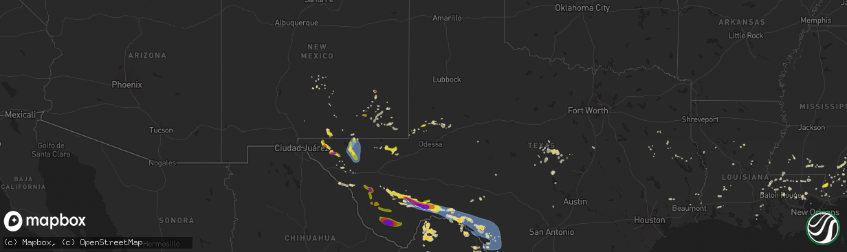
Hail Map on June 10, 2025
The weather event on June 10, 2025 includes Wind and Hail maps. 13 states and 365 cities were impacted and suffered possible damage. The total estimated number of properties impacted is 14,847.
Want more than just the map?
Turn this storm into a full workflow.
- Owner + property data so you know who to knock
- OnDemand branded weather history reports to win the "did we even have hail?" argument
- RoofTrace estimate so reps stop guessing numbers at the door
Bought this map? Upgrade within 7 days and we'll credit the $230. (10-15 min setup call)
Wind
Hail
14,847
Estimated number of impacted properties by a 1.00" hail or larger1,066
Estimated number of impacted properties by a 1.75" hail or larger165
Estimated number of impacted properties by a 2.50" hail or largerStates Impacted by Hail Map on June 10, 2025
Storm reports
Georgia
| Date | Description |
|---|---|
| 06/10/20253:36 PM CDT | A tree was reported down across bill rutledge road near matthews school road. |
| 06/10/20252:38 PM CDT | A tree was reported down in the 1500 block of lockridge drive. |
| 06/10/20258:21 AM CDT | Power lines down on walthour rd. |
| 06/10/20257:29 AM CDT | Tree down on arcola rd at hwy 26. |
| 06/10/20257:25 AM CDT | Tree down on cypress lake rd at country club rd. |
| 06/10/20257:21 AM CDT | Tree down on old portal rd. |
| 06/09/20258:03 PM CDT | Burke county dispatch reported a tree down along herndon rd. Time estimated based on radar. |
| 06/09/20257:57 PM CDT | Burke county dispatch reported powerlines down at 1071 hwy 80 in burke county. Time estimated based on radar. |
Louisiana
| Date | Description |
|---|---|
| 06/10/20254:52 PM CDT | Knew asos reported a gust of 58 mph. |
| 06/10/20254:33 PM CDT | Multiple trees and a few powerlines were downed by thunderstorms in madisonville. |
| 06/10/20253:49 PM CDT | Sheriffs office reported a tree down on highway 16... Near jenkins road 2. |
| 06/10/20253:45 PM CDT | Sheriffs office reported a tree down on sylvest road near highway 16. |
| 06/10/20253:42 PM CDT | Sheriffs office reported a tree down on highway 430 near franklinton. |
| 06/10/20253:23 PM CDT | Multiple trees down north of livingston. |
| 06/10/20253:23 PM CDT | Sheriffs office reported a tree down on james chapel road near highway 441. |
| 06/10/20253:21 PM CDT | Sheriffs office reported a tree down on east walker road. |
| 06/10/20253:19 PM CDT | Picture of large tree partially on a home northeast of walker shared by broadcast media. |
| 06/10/20253:03 PM CDT | Video on social media showed hail up to quarter size. |
| 06/10/20253:00 PM CDT | A comment on an emergency managers social media post showed a tree uprooted and minor roof damage to a home in st. Francisville. |
| 06/10/20252:29 PM CDT | Multiple pictures posted on social media showed several trees and large limbs downed by thunderstorm winds at hidden oaks campground... Just west of robert. |
| 06/10/20252:24 PM CDT | Sheriffs office reported a tree down on south ochsner road near robert. |
North Carolina
| Date | Description |
|---|---|
| 06/10/20256:51 PM CDT | Quarter to half dollar size hail observed. Additionally... Tree blown down in yard. |
| 06/10/20256:50 PM CDT | Multiple trees down just west of albemarle. |
| 06/10/20255:35 PM CDT | Utility company reports power outages due to fallen trees and large limbs damaging equipment. |
| 06/10/20251:24 PM CDT | Re |
| 06/10/20251:24 PM CDT | Report of a downed tree on a home near the cedar creek area. |
| 06/10/20251:10 PM CDT | Multiple power outages reported across southern onslow county by jones onslow emc. Time estimated from radar. |
| 06/10/202512:39 PM CDT | A local report indicates 61 MPH wind near Wilmington Intl Arpt |
Mississippi
| Date | Description |
|---|---|
| 06/10/20254:11 PM CDT | Broadcast media relayed a picture of trees down on a roadway in wiggins. Time estimated via radar. |
| 06/10/20252:37 PM CDT | Picture of hail estimated to be quarter sized west of mcneil. |
New Mexico
| Date | Description |
|---|---|
| 06/10/20253:42 PM CDT | Report of quarter sized hail near sever rivers... Off of us hwy 285. |
Florida
| Date | Description |
|---|---|
| 06/10/20254:10 PM CDT | Hail measuring up to one inch in diameter observed. |
| 06/10/20254:10 PM CDT | Delayed report. Wind damage to barns... Roof... And powerlines down. Time estimated from radar. Report found on social media. |
Montana
| Date | Description |
|---|---|
| 06/09/20258:18 PM CDT | Browning bia reported large hail. Location is estimated. |
| 06/09/20258:13 PM CDT | Hail up to walnut size. |
New York
| Date | Description |
|---|---|
| 06/10/20252:43 PM CDT | Reports of multiple trees down and damage to roof. |
| 06/10/20252:38 PM CDT | Reports of multiple downed trees were investigated and confirmed an ef-0 briefly touched down. Trees were uprooted and snapped. Part of a roof was peeled and wrapped ar |
Oklahoma
| Date | Description |
|---|---|
| 06/10/20255:31 PM CDT | Power poles downed... Video from social media. Time estimated from radar. |
| 06/10/20255:31 PM CDT | Numerous tree damage in indian springs area. Time estimated from radar. |
Texas
| Date | Description |
|---|---|
| 06/10/20256:43 PM CDT | Mesonet station ur249 6.7 e langtry |
| 06/10/20256:39 PM CDT | A local report indicates 59 MPH wind near 9 SE Hovey |
| 06/10/20256:38 PM CDT | Mesonet station ur144 14.1 sw toyah |
| 06/10/20256:08 PM CDT | A local report indicates 60 MPH wind near 4 NNW Belding |
| 06/10/20255:40 PM CDT | Mesonet station twb49 11.2 ne van horn |
| 06/10/20255:01 PM CDT | Awos station k6r6 5 w dryden recorded a storm-related gust of 93mph. |
| 06/10/20254:45 PM CDT | Estimated 70mph winds accompanied by small hail. |
| 06/10/20254:45 PM CDT | Uprooted tree. |
| 06/10/20254:37 PM CDT | Mesonet station 60 pine springs gmnp. |
| 06/10/20254:22 PM CDT | A local report indicates 58 MPH wind near Persimmon Gap |
| 06/10/20254:00 PM CDT | A local report indicates 58 MPH wind near 19 S Marfa |
| 06/10/20253:43 PM CDT | Quarter to ping pong ball sized hail reported by storm chaser near rm 169 and us 67. |
| 06/10/20253:09 PM CDT | [landspout] storm chaser reported large landspout moving southwest near paisano pass. |
| 06/10/20251:01 PM CDT | Andrews police department measured 1.25 inch hail. |
| 06/09/202511:20 PM CDT | Metal roofing material peeled of mobile home and garage. |
| 06/09/202511:05 PM CDT | Nws cooperative observer reported widespread thunderstorm wind damage in sabinal including broken power poles.. |
| 06/09/202511:05 PM CDT | Nws cooperative observer reporte |
| 06/09/202511:05 PM CDT | Nws cooperative observer reported widespread thunderstorm wind damage in sabinal including broken power poles... Downed trees... Damaged and destroyed outbuildings... A |
| 06/09/202510:15 PM CDT | Mesonet station tw101 camp eagle. |
| 06/09/20259:20 PM CDT | Emergency manager reports tree limbs down and power outages. |
| 06/09/20258:23 PM CDT | Asos station kdrt del rio intl airport. |
| 06/09/20257:50 PM CDT | A local report indicates 69 MPH wind near 3 NW Fort Stockton |
| 06/09/20257:35 PM CDT | A local report indicates 61 MPH wind near 1 ENE Thorntonville |
| 06/09/20257:35 PM CDT | A local report indicates 61 MPH wind near 1 ENE Thorntonville |
| 06/09/20257:05 PM CDT | Mesonet station twb47 13.9 se toyah lake |
| 06/09/20257:00 PM CDT | Mesonet station twb98 gray ranch. |
Alabama
| Date | Description |
|---|---|
| 06/10/20253:19 PM CDT | Public reports quarter sized hail in pineview... Al. Time estimated via radar. |
South Carolina
| Date | Description |
|---|---|
| 06/10/20259:50 AM CDT | 911 dispatch reported large tree down on power lines. |
| 06/10/20259:40 AM CDT | Tree down on fickling hill rd at brownswood rd. |
| 06/10/20259:10 AM CDT | Tree and power lines down on chinese dog run ln at bama rd. |
| 06/10/20259:01 AM CDT | Tree and power lines down on featherbed rd. |
| 06/10/20258:53 AM CDT | Tree down on mable t willis blvd. |
| 06/10/20258:53 AM CDT | Tree down at bells hwy and stokes rd. |
| 06/10/20258:53 AM CDT | Tree down at stormy ln and bells hwy. |
| 06/10/20258:41 AM CDT | 10-12 inch diameter hardwood limb snapped off by thunderstorm wind. |
| 06/10/20258:40 AM CDT | Tree down at wash farm rd near trask pkwy. |
| 06/10/20258:40 AM CDT | Tree down on henderson rd at old salkehatchie rd. |
| 06/10/20258:37 AM CDT | Tree down on old sheldon church rd at bailey rd. |
| 06/10/20258:34 AM CDT | Tree down on possum corner at yemassee hwy. |
| 06/10/20258:32 AM CDT | Tree down on hwy 68 at grays hwy. |
| 06/10/20258:30 AM CDT | Tree down on henderson rd at yemassee hwy. |
| 06/10/20258:25 AM CDT | Tree down on coosaw scenic dr at salzburg rd. |
| 06/10/20258:22 AM CDT | Tree down on rivers hill rd. |
| 06/10/20258:21 AM CDT | Tree down on honey hill circle at old house rd. |
| 06/10/20258:21 AM CDT | Tree down on speed limit rd at uncle jims lane. |
| 06/10/20258:18 AM CDT | Tree down on forest ave at wise st. |
Cities Impacted by Hail Map on June 10, 2025
- Early, TX
- Zephyr, TX
- Richland Springs, TX
- Mullin, TX
- Blanket, TX
- Comanche, TX
- Brownwood, TX
- Goldthwaite, TX
- San Saba, TX
- Hamilton, TX
- Pottsville, TX
- Priddy, TX
- Evant, TX
- Lampasas, TX
- Burnet, TX
- Purmela, TX
- Waco, TX
- West, TX
- Elm Mott, TX
- Grapeland, TX
- San Augustine, TX
- Rusk, TX
- Bronson, TX
- Boyce, LA
- Elmer, LA
- Andrews, TX
- Chireno, TX
- Many, LA
- Marathon, TX
- Ruidoso, NM
- Tarzan, TX
- Victoria, TX
- Nacogdoches, TX
- Mescalero, NM
- Alto, NM
- Zwolle, LA
- Mount Enterprise, TX
- Gulfport, MS
- Stanton, TX
- Cushing, TX
- Wilmington, NC
- Leland, NC
- Winnabow, NC
- Castle Hayne, NC
- Hampstead, NC
- Rocky Point, NC
- Holly Ridge, NC
- Fort Davis, TX
- Lenorah, TX
- Biloxi, MS
- Melbourne, FL
- Sneads Ferry, NC
- Jacksonville, NC
- Jena, LA
- Hubert, NC
- Whitesburg, GA
- Robeline, LA
- Natchitoches, LA
- Mobile, AL
- Carrollton, GA
- Ponchatoula, LA
- Robert, LA
- Loranger, LA
- Lucedale, MS
- Krotz Springs, LA
- Alpine, TX
- Pinon, NM
- Kokomo, MS
- Tylertown, MS
- Moss Point, MS
- Bush, LA
- Covington, LA
- Carrizozo, NM
- Saint Francisville, LA
- Troup, TX
- Lamesa, TX
- Wilmer, AL
- Marietta, GA
- Foxworth, MS
- Kennesaw, GA
- Vidalia, LA
- Newnan, GA
- Jay, FL
- Palmetto, GA
- Jarreau, LA
- Oscar, LA
- Lakeland, LA
- Immokalee, FL
- Picayune, MS
- Carriere, MS
- Geneva, AL
- New Roads, LA
- Erwinville, LA
- Baton Rouge, LA
- Morganza, LA
- Broaddus, TX
- Lake Wales, FL
- Hammond, LA
- Rougon, LA
- Cumming, GA
- Ethel, LA
- Columbia, MS
- Leakesville, MS
- Port Allen, LA
- Chunchula, AL
- Perkinston, MS
- Wiggins, MS
- McIntosh, AL
- Greensburg, LA
- Jackson, LA
- Donalsonville, GA
- Slaughter, LA
- Clinton, LA
- Alpharetta, GA
- Atmore, AL
- Uriah, AL
- Port Neches, TX
- Andalusia, AL
- Red Level, AL
- Iron City, GA
- Moore Haven, FL
- Georgetown, LA
- Citronelle, AL
- Little River, AL
- Forkland, AL
- Meadville, MS
- Tularosa, NM
- Flomaton, AL
- Poplarville, MS
- Amite, LA
- Fluker, LA
- Roseland, LA
- Kentwood, LA
- Elba, AL
- Richton, MS
- Beaumont, MS
- Lumberton, MS
- Wagarville, AL
- Denham Springs, LA
- Pine Grove, LA
- Walker, LA
- Saratoga, TX
- Centreville, MS
- Norwood, LA
- Port Arthur, TX
- Vinegar Bend, AL
- State Line, MS
- Mount Hermon, LA
- Brewton, AL
- Venus, FL
- Cleveland, TX
- Cloudcroft, NM
- Dell City, TX
- Valentine, TX
- Fruitdale, AL
- Vidor, TX
- Tullos, LA
- Greensboro, AL
- Gallion, AL
- Winnfield, LA
- Punta Gorda, FL
- Purvis, MS
- Hattiesburg, MS
- Brooklyn, MS
- Franklinton, LA
- Mccomb, MS
- Okeechobee, FL
- Conyers, GA
- Loganville, GA
- Marfa, TX
- Range, AL
- Repton, AL
- Oberlin, LA
- Zolfo Springs, FL
- Tibbie, AL
- Faunsdale, AL
- Livingston, LA
- Arcadia, FL
- Oxford, GA
- Summit, MS
- Greenwood, FL
- Grand Ridge, FL
- Marianna, FL
- Deer Park, AL
- Forest Home, AL
- Greenville, AL
- Reeves, LA
- Roswell, NM
- Auburn, GA
- Winder, GA
- Castleberry, AL
- Evergreen, AL
- Springfield, LA
- Fort Stockton, TX
- Dryden, TX
- Jack, AL
- Pendergrass, GA
- Lake Charles, LA
- Georgiana, AL
- Artesia, NM
- Jayess, MS
- Lake Arthur, NM
- Lenox, AL
- Midland City, AL
- Petal, MS
- Dozier, AL
- Kinder, LA
- Commerce, GA
- Bigfork, MT
- Fort Hancock, TX
- New Augusta, MS
- Avon Park, FL
- Saint Augustine, FL
- Elkton, FL
- Brantley, AL
- Headland, AL
- Hagerman, NM
- Ragley, LA
- Salt Flat, TX
- Safford, AL
- Wauchula, FL
- Dacula, GA
- Bogue Chitto, MS
- Ruth, MS
- McHenry, MS
- Cairo, GA
- Glenwood, AL
- Saint Martinville, LA
- Carlsbad, NM
- Sanderson, TX
- Call, TX
- Shorterville, AL
- Camden, AL
- Troy, AL
- Columbia, AL
- Beatrice, AL
- Vredenburgh, AL
- Brundidge, AL
- Bell City, LA
- Chatom, AL
- Coy, AL
- Maiden, NC
- Ovett, MS
- Denver, NC
- Sierra Blanca, TX
- Lakeland, FL
- Auburndale, FL
- Orrville, AL
- Abita Springs, LA
- Pearl River, LA
- Iowa, LA
- New Iberia, LA
- Van Horn, TX
- Davidson, NC
- Mooresville, NC
- Cornelius, NC
- Polk City, FL
- Pennington, AL
- Stennis Space Center, MS
- Winston, GA
- New Brockton, AL
- Opp, AL
- Gantt, AL
- Minter, AL
- Vero Beach, FL
- Bluffton, GA
- Edison, GA
- Douglasville, GA
- Orlando, FL
- Sweet Water, AL
- Moultrie, GA
- Pavo, GA
- Berlin, GA
- Meridian, MS
- Huntersville, NC
- Comstock, TX
- Maljamar, NM
- Semmes, AL
- Gotha, FL
- Windermere, FL
- Ocoee, FL
- Winter Garden, FL
- Mentone, TX
- Pecos, TX
- Deatsville, AL
- Titus, AL
- Adel, GA
- Marbury, AL
- Termo, CA
- Concord, NC
- Mount Pleasant, NC
- Jal, NM
- Madeline, CA
- Albany, GA
- Wetumpka, AL
- Montague, CA
- Zachary, LA
- Albemarle, NC
- Verbena, AL
- New London, NC
- Locust, NC
- Fort McCoy, FL
- Del Rio, TX
- Clanton, AL
- Billingsley, AL
- Astor, FL
- Crescent City, FL
- Georgetown, FL
- McCall Creek, MS
- Park City, MT
- Rocksprings, TX
- Dairy, OR
- Klamath Falls, OR
- Gibson, GA
- Mitchell, GA
- Smithdale, MS
- Holden, LA
- Ozona, TX
- Leesburg, GA
- Richfield, NC
- Avera, GA
- Stapleton, GA
- Sonora, TX
- Brackettville, TX
- Tallassee, AL
- Kissimmee, FL
- Browning, MT
- Laughlin Afb, TX
- Chiloquin, OR
- Moore, MT
- Buffalo, MT
- Lavina, MT
- Roundup, MT
- Waynesville, GA
- Loving, NM
- Lewistown, MT
- Hobson, MT
- Valier, MT
- Quemado, TX
- Christoval, TX
- Sterling City, TX
- Uvalde, TX
- La Pryor, TX
- Broken Arrow, OK
- Tulsa, OK
- Bixby, OK
- Tulelake, CA
- Blanco, TX
- Sprague River, OR
- Gatesville, TX
- Lometa, TX
- San Ygnacio, TX
- Zapata, TX
- Mirando City, TX
- Roma, TX
- West Point, IA
- Batavia, IA
- Libertyville, IA
- Fairfield, IA
- Hillsboro, IA
- Salem, IA
- Donnellson, IA
- Fort Madison, IA
- Ottumwa, IA
- Robstown, TX