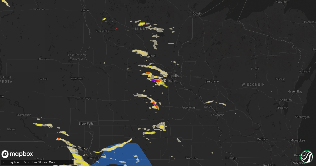
Hail Map on June 16, 2025
Get this storm
June 16 map
$229
one time, instant access
Download today. No call, no setup
Keep the $229
Bought the map and want the full workflow? Apply the entire $229 to a subscription within 7 days. None of it is wasted.
Every map, not just this one
This buys you this map. Subscription and you get every map we run, in the markets you choose from a few cities to whole states to nationwide. Plus real-time alerts the moment a storm fires.
Contact data
Name, contact info, occupancy, even credit band for addresses in the footprint. You go from where it hit to who to call.
Become the source they trust
Unlimited branding weather history reports on demand. You already have the documented answer ready for the property owner, and you are the one who showed up with it.
Property data and RoofTrace estimates
Pull up any address you have got, its value and the exact code rules for that jurisdiction, straight from One Click Code. Then RoofTrace estimates the squares, pitch, and roof value, priced the way you price.
States Impacted by Hail Map on June 16, 2025
Storm reports
Kansas
| Date | Description |
|---|---|
| 06/16/20256:55 PM CDT | Nickel to quarter sized hail ongoing over a duration of 10 minutes. |
| 06/16/202512:40 PM CDT | Up846 reported the gust. |
| 06/16/20255:48 AM CDT | A local report indicates 60 MPH wind near Arkansas City |
| 06/16/20255:44 AM CDT | Power outages reported in winfield. |
| 06/16/20255:40 AM CDT | Estimated 4 foot diameter cottonwood tree fell onto powerline which has since snapped that pole. |
| 06/16/20255:40 AM CDT | Estimated 4 foot d |
| 06/16/20255:40 AM CDT | Estimated 4 foot diameter cottonwood tree fell onto powerline which has since snapped that p |
| 06/16/20255:35 AM CDT | Reported at kwld. |
| 06/16/20255:31 AM CDT | Asos station kwld strother field airport. |
| 06/16/20255:07 AM CDT | A local report indicates 60 MPH wind near 1 NW Udall |
| 06/16/20254:56 AM CDT | A local report indicates 62 MPH wind near Benton |
| 06/16/20254:55 AM CDT | Awos station kbec beech factory airport. |
| 06/16/20254:55 AM CDT | Awos station kiab mcconnell afb. |
| 06/16/20254:55 AM CDT | Two power poles snapped off. Time estimated from radar. |
| 06/16/20254:54 AM CDT | Street light blocking road in the 600 block of e. 36th in newton. |
| 06/16/20254:53 AM CDT | Several power lines down across wichita metro. |
| 06/16/20254:46 AM CDT | Large tree down across burmac and 84th road. |
| 06/16/20254:42 AM CDT | Reported large tree fell on homes and a person was stuck inside home at 1200 block s pershing. No injuries. |
| 06/16/20254:41 AM CDT | Several large 3 inch diameter tree branches down. Power pole leaning over roadway. Time estimated from radar. |
| 06/16/20254:37 AM CDT | A local report indicates 80 MPH wind near 1 WNW East Wichita |
| 06/16/20254:36 AM CDT | Power line down at east 4th street. |
| 06/16/20254:35 AM CDT | Awos station kaao 2 ese bel aire. |
| 06/16/20254:35 AM CDT | A local report indicates 80 MPH wind near Conway Springs |
| 06/16/20254:34 AM CDT | A local report indicates 85 MPH wind near Jabara Airport |
| 06/16/20254:24 AM CDT | Mesonet station up317 0.8 w canton |
| 06/16/20254:22 AM CDT | Reported at kict. |
| 06/16/20254:08 AM CDT | Large tree down at sw 96th and burmac road. |
| 06/16/20254:00 AM CDT | Large tree down. |
| 06/16/20253:57 AM CDT | At least 70 mph estimated. |
| 06/16/20253:55 AM CDT | Measured at the mcpherson airport. |
| 06/16/20253:54 AM CDT | At least 80 mph in the city of mount hope. |
| 06/16/20253:53 AM CDT | A local report indicates 70 MPH wind near Mount Hope |
| 06/16/20253:38 AM CDT | Wind gusts between 70 to 80 mph estimated. |
| 06/16/20253:31 AM CDT | Asos station khut hutchinson municipal airport. |
| 06/16/20253:30 AM CDT | Spotter estimated 70-80 mph wind gusts. Very heavy rainfall as well. |
| 06/16/20253:03 AM CDT | Reports of trees down |
| 06/16/20253:02 AM CDT | Report from kansas mesonet. |
| 06/16/20252:55 AM CDT | Awos station klyo lyons rice co. Municipal airpt. |
| 06/16/20252:45 AM CDT | Via social media. Delayed report. Downed tree of unknown diameter. Power is also out. |
| 06/16/20252:34 AM CDT | A local report indicates 62 MPH wind near 3 N New Cambria |
| 06/16/20252:32 AM CDT | A 7-inch diameter dead tree branch broken off and on the ground. This report received from social media. |
| 06/16/20252:32 AM CDT | Mesonet station ur445 3.2 e new cambria |
| 06/16/20252:25 AM CDT | Reported by the kansas state mesonet. |
| 06/16/20252:23 AM CDT | Report received from the kansas state mesonet. |
| 06/16/20252:21 AM CDT | Personal weather station. |
| 06/16/20252:14 AM CDT | Time estimated radar. 4 inch diameter tree limb over road. Delayed report. |
| 06/16/20252:14 AM CDT | Personal weather station. |
| 06/16/20252:12 AM CDT | A local report indicates 58 MPH wind near 3 NE Pawnee Rock |
| 06/16/20252:10 AM CDT | A local report indicates 70 MPH wind near 6 N Wells |
| 06/16/20252:05 AM CDT | Delayed report. |
| 06/16/20252:05 AM CDT | Delayed report. |
| 06/16/20251:49 AM CDT | Personal weather station. |
| 06/16/20251:34 AM CDT | Asos station krsl russell municipal airport. |
| 06/16/20251:25 AM CDT | Asos station krsl russell municipal airport. |
| 06/16/20251:25 AM CDT | Spotter also lost power with the strong winds. |
| 06/16/20251:22 AM CDT | Personal weather station. Delayed report. |
| 06/16/20251:18 AM CDT | Ksu mesonet. |
| 06/16/20251:01 AM CDT | A local report indicates 72 MPH wind near 9 NNE Yocemento |
| 06/16/202512:57 AM CDT | A local report indicates 59 MPH wind near 9 NNE Ellis |
| 06/16/202512:50 AM CDT | A local report indicates 60 MPH wind near Hunter |
| 06/16/202512:48 AM CDT | Ksu mesonet. |
| 06/16/202512:36 AM CDT | Mesonet station up846 2.0 e quinter |
| 06/15/202511:40 PM CDT | Dispatch reports a few stones up to 1 inch diameter... Most smaller. |
| 06/15/202511:28 PM CDT | Delayed report. Relayed through em. |
| 06/15/202510:38 PM CDT | Pws-kksnorca2. |
| 06/15/202510:34 PM CDT | Corrects previous tstm wnd gst report from 3 nw calvert. Awn geil lodge gust. |
| 06/15/202510:21 PM CDT | Spotter reported multiple 8 inch green tree limbs blown roughly 300-350 feet to the north from the trees. Also reported numerous 3-5 inch tree limbs on the ground as we |
| 06/15/202510:21 PM CDT | Delayed report. Trained spotter found additional 12 inch green tree limb down the next morning. |
| 06/15/202510:16 PM CDT | Public report of 60 mph winds and blowing dust with visibility near 0. |
| 06/15/202510:16 PM CDT | Public report of 60 mph winds and blowing dust with visibility near 0. |
| 06/15/202510:15 PM CDT | Awos station koin oberlin. |
| 06/15/202510:15 PM CDT | Ksyf reported the wind gust. |
| 06/15/202510:00 PM CDT | Social media report with pictures of damage to an out building and a tree limb down from the winds. |
| 06/15/20259:56 PM CDT | A local report indicates 60 MPH wind near 7 SSE Norton |
| 06/15/20259:55 PM CDT | Awos station koin oberlin. |
| 06/15/20259:33 PM CDT | Report of brick car wash collapsing from winds. |
| 06/15/20259:15 PM CDT | Awos station ksyf st. Francis city. |
| 06/15/20259:15 PM CDT | A local report indicates 58 MPH wind near 4 N Ludell |
| 06/15/20258:55 PM CDT | A local report indicates 60 MPH wind near 8 SSE Bird City |
| 06/15/20258:54 PM CDT | Spotter estimated 70 to 80 mph winds with blowing dust creating visibility reductions of 1/8 to 1/2 half mile. |
| 06/15/20258:53 PM CDT | A local report indicates 58 MPH wind near 4 WNW Bird City |
| 06/15/20258:43 PM CDT | Awos station ksyf st. Francis city. |
| 06/15/20258:40 PM CDT | Estimated 70-80 mph winds off and on. |
| 06/15/20258:40 PM CDT | Winds estimated and coming out of the southeast. |
| 06/15/20258:21 PM CDT | Reported via ks mesonet cheyenne station. |
| 06/15/20257:55 PM CDT | Reported via weatherunderground station kkskanor6. |
Indiana
| Date | Description |
|---|---|
| 06/16/20252:10 PM CDT | Trees uprooted and limbs dama |
| 06/16/20252:10 PM CDT | Trees uprooted and limbs damaged from high wind. |
Kentucky
| Date | Description |
|---|---|
| 06/15/20258:02 PM CDT | Delayed report. Picture on social media of downed trees and power lines blocking croley bend road in williamsburg. Time estimated via radar. |
North Dakota
| Date | Description |
|---|---|
| 06/16/20256:25 PM CDT | Mchenry county sheriffs office and other trained weather spotters report and sent photos of two large grain silos knocked over with other close by grain silos damaged f |
Alabama
| Date | Description |
|---|---|
| 06/16/20256:58 PM CDT | Several reports of trees and power lines down across springville... Odenville... Ashville... And northeast trussville. |
| 06/16/20256:42 PM CDT | Various reports of trees down across center point. Time estimated from radar. |
| 06/16/20256:42 PM CDT | Trees down around palmerdale. Time estimated from radar. |
| 06/16/20256:16 PM CDT | Tree down near highway 78 and main street. Time estimated from radar. |
| 06/16/20256:16 PM CDT | Trees down. Time estimated from radar. |
| 06/16/20255:43 PM CDT | Trees down in the lake view area. |
| 06/16/20255:32 PM CDT | Trees down in the samantha area. |
| 06/16/20255:20 PM CDT | Trees down in the vance area. |
| 06/16/20254:54 PM CDT | Trees and power lines down in the carrollton area. |
| 06/16/20254:50 PM CDT | Trees down in the duncanville area. |
| 06/16/20254:46 PM CDT | Trees and power lines down in the pickensville area. |
| 06/16/20254:40 PM CDT | Trees and power lines down in the aliceville area. |
| 06/16/20254:25 PM CDT | Tree down near the intersection of cr 21 and cr 55. |
| 06/15/20258:10 PM CDT | Numerous reports of trees and power lines down around cherokee county... Especially the northern half. |
| 06/15/20257:03 PM CDT | Tree down on house. Time estimated from radar. |
Nebraska
| Date | Description |
|---|---|
| 06/16/20256:22 PM CDT | A local report indicates 1.00 inch wind near 4 S Norfolk |
| 06/16/20256:20 PM CDT | A local report indicates 1.00 inch wind near 7 W Stanton |
| 06/16/20256:17 PM CDT | A local report indicates 1.50 inch wind near 5 S Norfolk |
| 06/16/20256:17 PM CDT | Personal weather station measured wind gust of 64 mph. |
| 06/16/20256:10 PM CDT | A local report indicates 1.00 inch wind near 2 SSW Neligh |
| 06/16/20255:43 PM CDT | A local report indicates 1.00 inch wind near 4 NNE Meadow Grove |
| 06/16/20255:40 PM CDT | Delayed public report shared on social media with a hailstone measured at 1 inch in diameter. Time estimated from radar. |
| 06/16/20255:15 PM CDT | Law enforcement report of hail up to quarter sized along with heavy rain. |
| 06/16/20255:13 PM CDT | Emergency management report of straight line winds gusting at 60-65 mph. |
| 06/16/20255:13 PM CDT | Emergency management report of heavy rain and wind gusts of 50-60 mph. |
| 06/16/20255:11 PM CDT | Accompanied by 45 mph winds. |
| 06/16/20255:05 PM CDT | Public report of hail estimated up to 1 inch in diameter. |
| 06/16/20254:30 PM CDT | Emergency management report of irrigation flipped two miles south of laurel along with power lines down in that area. Time estimated with radar. |
| 06/16/20254:28 PM CDT | Report via social media. Trees knocked down by thunderstorm wind gusts. |
| 06/16/20254:02 PM CDT | A local report indicates 1.00 inch wind near Hartington |
| 06/16/20254:00 PM CDT | Mesonet measured wind gust of 63 mph. |
| 06/16/20254:00 PM CDT | Mesonet measured wind gust of 58 mph. |
| 06/16/20252:45 AM CDT | A local report indicates 1.00 inch wind near 10 SE Harrisburg |
| 06/16/20251:58 AM CDT | A local report indicates 1.00 inch wind near Kimball |
| 06/16/20251:52 AM CDT | Several house windows blown out by hailstones. |
| 06/16/20251:31 AM CDT | A local report indicates 1.00 inch wind near 10 N Bushnell |
| 06/16/20251:21 AM CDT | A local report indicates 1.75 inch wind near 0.5 E Scottsbluff |
| 06/16/20251:17 AM CDT | A local report indicates 1.50 inch wind near 2 E Scottsbluff |
| 06/15/202511:19 PM CDT | A local report indicates 62 MPH wind near Franklin |
| 06/15/202511:01 PM CDT | A local report indicates 64 MPH wind near 3 W Republican City |
| 06/15/202511:00 PM CDT | Time estimated from radar. Lots of trees broken off throughout town with some large branches. |
| 06/15/202510:53 PM CDT | Site wl-bloomington8.16nnw. |
| 06/15/202510:50 PM CDT | Site pws-knewilco20. |
| 06/15/202510:48 PM CDT | A local report indicates 63 MPH wind near 1 N Republican City |
| 06/15/202510:47 PM CDT | A local report indicates 63 MPH wind near 6 WSW Ragan |
| 06/15/202510:46 PM CDT | A local report indicates 63 MPH wind near 3 W Republican City |
| 06/15/202510:45 PM CDT | A local report indicates 62 MPH wind near 7 ENE Huntley |
| 06/15/202510:43 PM CDT | A local report indicates 73 MPH wind near 4 SE Huntley |
| 06/15/202510:40 PM CDT | Social media report of estimated 60 mph wind gust. |
| 06/15/202510:38 PM CDT | Site wl-huntley3.86ene. |
| 06/15/202510:33 PM CDT | A local report indicates 58 MPH wind near 6 W Huntley |
| 06/15/202510:21 PM CDT | A local report indicates 68 MPH wind near 2 ENE Hastings |
| 06/15/202510:19 PM CDT | A local report indicates 70 MPH wind near 5 SSW Hastings |
| 06/15/202510:18 PM CDT | A local report indicates 67 MPH wind near 2 E Juniata |
| 06/15/202510:16 PM CDT | A local report indicates 59 MPH wind near 4 SW Hastings |
| 06/15/202510:16 PM CDT | Pictures shared on facebook of tree damage on southern hills golf course. |
| 06/15/202510:16 PM CDT | A local report indicates 59 MPH wind near 4 SW Hastings |
| 06/15/202510:13 PM CDT | Em reports some trees down and powerline on a car near center of city. |
| 06/15/202510:13 PM CDT | A local report indicates 61 MPH wind near Hastings Airport |
| 06/15/202510:10 PM CDT | Estimated 60 to 65 mph winds at nws hastings office. |
| 06/15/202510:08 PM CDT | A local report indicates 59 MPH wind near Grand Island Airport |
| 06/15/202510:06 PM CDT | A local report indicates 59 MPH wind near Ord Airport |
| 06/15/20259:48 PM CDT | Delayed report from yesterdays storms. Nws employee reports numerous tree branches and limbs 2-8 inches in diameter across various portions of grand island. Time estima |
| 06/15/20259:43 PM CDT | Also reported 50 to 60mph winds. |
| 06/15/20259:40 PM CDT | Report from site kneraven17. |
| 06/15/20259:34 PM CDT | A local report indicates 1.75 inch wind near Sutherland |
| 06/15/20259:28 PM CDT | Estimated brief 60 mph wind gust. |
| 06/15/20259:28 PM CDT | Estimated 40-50 mph persisting winds with brief gusts up to 60 mph. |
| 06/15/20259:20 PM CDT | Report from mping. |
| 06/15/20259:18 PM CDT | Estimated winds 50 to 60 mph... Also hail up to dime size. |
| 06/15/20259:16 PM CDT | Brief wind gust |
| 06/15/20259:16 PM CDT | Brief wind gusts up to 60 mph. |
| 06/15/20259:14 PM CDT | A local report indicates 1.00 inch wind near 12 S Wallace |
| 06/15/20258:55 PM CDT | Large branch down on property. Reports of several other reports of 2 to 4 inch branches down in town. |
| 06/15/20258:55 PM CDT | Several reports of branches at least 2 to 4 inch diameter down in town... Including from off-duty nws. |
| 06/15/20258:45 PM CDT | A local report indicates 1.00 inch wind near 3 NE Belgrade |
| 06/15/20258:43 PM CDT | A local report indicates 1.00 inch wind near 2 SW Maxwell |
| 06/15/20258:31 PM CDT | Personal weather station measured gust of 61 mph... Likely associated with the passing of an outflow boundary. |
| 06/15/20258:29 PM CDT | Quarter size hail. |
| 06/15/20258:25 PM CDT | A local report indicates 1.00 inch wind near Cedar Rapids |
| 06/15/20258:24 PM CDT | Up to quarter size hail...most smaller. |
| 06/15/20258:19 PM CDT | A local report indicates 1.00 inch wind near Genoa |
| 06/15/20258:15 PM CDT | Preliminary reports of of tree and power line damage in town. Extent unknown at this time. |
| 06/15/20258:15 PM CDT | Updates previous tstm wnd gst report from lexington airport. Intense gusts several miles out ahead of nearby thunderstorms. Dispatch reporting some tree and power line |
| 06/15/20258:15 PM CDT | Intense gusts several miles out ahead of nearby thunderstorms. Dispatch reporting some tree and power line damage. |
| 06/15/20258:15 PM CDT | Update to previous tstm wnd dmg report from lexington. Preliminary reports of of tree and power line damage in town. Extent unknown at this time. It appears this likely |
| 06/15/20258:09 PM CDT | Corrects previous hail report from 2 sw maxwell. |
| 06/15/20258:09 PM CDT | A local report indicates 1.75 inch wind near 8 E Saint Edward |
| 06/15/20257:48 PM CDT | Personal weather station measured wind gust of 63 mph. |
| 06/15/20257:32 PM CDT | A local report indicates 1.00 inch wind near 5 SW Newman Grove |
| 06/15/20257:25 PM CDT | A local report indicates 2.50 inch wind near 5 E Dickens |
| 06/15/20257:21 PM CDT | Personal weather station measured wind gust of 64 mph. |
| 06/15/20257:21 PM CDT | Personal weather station measured wind gust of 64 mph. |
| 06/15/20257:21 PM CDT | Personal weather station measured wind gust of 64 mph. |
| 06/15/20257:07 PM CDT | Multiple reports over phone and social media of tornado on the ground. |
| 06/15/20257:06 PM CDT | Report of snapped tree limbs of 3 inches in diameter. |
| 06/15/20257:04 PM CDT | [landspout] landspout touched down and moved to the west-southwest for approximately 1 mile before ending. |
Wyoming
| Date | Description |
|---|---|
| 06/16/20256:42 PM CDT | Time estimated via radar. |
| 06/16/20256:30 PM CDT | A local report indicates 1.00 inch wind near Douglas |
| 06/16/20256:15 PM CDT | Consistently hailing to quarter size. |
| 06/16/20255:48 PM CDT | Em reported closer to 2 and a quarter inch size hail. |
| 06/16/20254:45 PM CDT | Center manager of the casper interagency dispatch center reported egg size hail. |
| 06/16/20254:40 PM CDT | A local report indicates 1.00 inch wind near 2 NNE Cheyenne |
| 06/16/20251:49 AM CDT | A local report indicates 1.25 inch wind near 1 S Hawk Springs |
| 06/16/202512:35 AM CDT | A local report indicates 1.75 inch wind near 5 NE Gun Barrel |
| 06/15/202511:06 PM CDT | A local report indicates 63 MPH wind near 10 S Upton |
| 06/15/20259:51 PM CDT | A local report indicates 66 MPH wind near 1 NE Echeta |
| 06/15/20259:33 PM CDT | A local report indicates 1.25 inch wind near 2 ENE Weston |
| 06/15/20259:20 PM CDT | At least quarter sized hail. |
| 06/15/20258:57 PM CDT | A local report indicates 1.50 inch wind near 3 ENE Spotted Horse |
| 06/15/20258:51 PM CDT | A local report indicates 1.75 inch wind near Spotted Horse |
| 06/15/20258:50 PM CDT | A local report indicates 1.75 inch wind near 5 W Spotted Horse |
| 06/15/20257:00 PM CDT | Estimated 60 mph wind gust. |
Virginia
| Date | Description |
|---|---|
| 06/16/20253:24 PM CDT | Thunderstorm winds blew down multiple trees near the intersection of morgan ford road and axton road. |
Mississippi
| Date | Description |
|---|---|
| 06/16/20254:26 PM CDT | Tree down on washington street. Multiple power outages in the county as well. |
| 06/16/20253:44 PM CDT | A few trees down. |
| 06/16/20253:37 PM CDT | Couple trees down. |
| 06/16/20253:36 PM CDT | A few trees down around town. One tree on a power line. |
| 06/16/20253:27 PM CDT | A few trees down. |
| 06/16/20253:26 PM CDT | A few trees down in the bailey area. |
| 06/16/20253:20 PM CDT | Trees were downed on hickory ln... Steeplechase dr... And northdale dr. |
| 06/16/20253:10 PM CDT | Measured 61 mph gust at kmei. |
| 06/16/20253:09 PM CDT | Trees down on arundel road. |
| 06/16/20252:58 PM CDT | Trees down near hwy 13 and ludlow road. |
| 06/16/20252:25 PM CDT | Tree down on rankin road. |
| 06/16/20252:10 PM CDT | Tree down blocking clara foote road. |
Oklahoma
| Date | Description |
|---|---|
| 06/16/20256:59 AM CDT | A local report indicates 66 MPH wind near 3 NW Stillwater |
| 06/16/20256:05 AM CDT | A local report indicates 58 MPH wind near 8 E Newkirk |
Iowa
| Date | Description |
|---|---|
| 06/16/20256:14 PM CDT | Personal weather station. |
| 06/16/20255:48 PM CDT | Roof peeled off a building. Power outages throughout town. |
| 06/16/20255:47 PM CDT | Corrects previous tstm wnd gst report from 1 s cherokee. Awos station kckp cherokee municipal airport. |
| 06/16/20255:47 PM CDT | Awos station kckp cherokee municipal airport. |
| 06/16/20255:46 PM CDT | Several large limbs down. |
| 06/16/20255:37 PM CDT | Personal weather station. |
| 06/16/20255:34 PM CDT | Personal weather station. |
| 06/16/20255:33 PM CDT | A local report indicates 58 MPH wind near 4 W Correctionville |
| 06/16/20255:25 PM CDT | Multiple trees down in pierson. |
| 06/16/20255:10 PM CDT | Lots of branches knocked down in yard and house roof. Speed estimated at 70 mph... Due to moderate size of branches. |
| 06/16/20254:48 PM CDT | Power lines and several trees down near the intersection of k22 and c60. |
| 06/16/202510:00 AM CDT | Relayed through ema social media. |
| 06/15/20259:08 PM CDT | Strong wind gusts reported in atlantic... With medium to large sized tree branches down blocking multiple roads. Pea-sized hail was observed at times... With heavy rain |
| 06/15/20259:03 PM CDT | Personal weather station measured gust of 62 mph. |
| 06/15/20257:51 PM CDT | Personal weather station gusted to 60 mph. |
| 06/15/20257:09 PM CDT | Personal weather station gusted to 59 mph as the gust front moved through. |
Minnesota
| Date | Description |
|---|---|
| 06/16/20256:44 PM CDT | Nws employee reported half dollar sized hail in waconia. |
| 06/16/20256:36 PM CDT | Storms chasers confirmed brief tornado touched down just north of courtland. |
| 06/16/20256:30 PM CDT | Large tree branch broken off mature tree... Several inches in diameter. Photo via social media. Time estimated. |
| 06/16/20256:28 PM CDT | Large limb broken off mature tree. Time estimated from radar. |
| 06/16/20256:17 PM CDT | Around an 8 inch diameter pine tree down. Multiple other branches down. Time estimated by radar. |
| 06/16/20255:46 PM CDT | A local report indicates 1.75 inch wind near 2 ESE Cokato |
| 06/16/20255:44 PM CDT | A local report indicates 1.00 inch wind near Cokato |
| 06/16/20255:30 PM CDT | Debris reported in the air and on the ground. |
| 06/16/20255:25 PM CDT | Multiple reports of quarter sized hail south of dassel. |
| 06/16/20254:58 PM CDT | Trees fallen in multiple directions at the location. Time estimated from radar. |
| 06/16/20254:50 PM CDT | Several pictures received of downed trees that appeared to be a combination of snapped and uprooted...a business sign...and fence damage due to strong thunderstorm wind |
| 06/16/20254:50 PM CDT | Many trees down. Some uprooted and some snapped anywhere from 10 to 20 ft. Plastic chair flung into and broken onto and around a tree trunk. Time estimated from radar. |
| 06/16/20254:42 PM CDT | A local report indicates 1.00 inch wind near 1 NNW Lake Shore |
| 06/16/20254:40 PM CDT | Photo was received showing larger than quarter-sized hail. |
| 06/16/20254:35 PM CDT | Report of a tornado confirmed touchdown in homebrook township mn. Heading from west to south east toward nisswa. |
| 06/16/20254:34 PM CDT | A local report indicates a tornado near Lake Shore |
| 06/16/20254:30 PM CDT | Report of a tornado on the ground...estimated 5.5 to 7 miles north of the mn state highway 210 and bridgeman road intersection. Touchdown around 430 pm. Appeared to be |
| 06/16/20254:22 PM CDT | Multi-vortex tornado reported on the ground in casino. Video confirmation as well. |
| 06/16/20253:41 PM CDT | Law enforcement dispatch reported roof blown off of barn near bertha. |
| 06/16/20253:38 PM CDT | A photo looking north of a wall cloud/lowering was reported on social media. Location estimated via radar. |
| 06/16/20253:00 PM CDT | A photo from social media of a tornadic storm was reported near deer creek... Minnesota. |
| 06/16/20252:49 PM CDT | A video of a funnel on social media was reported west of deer creek... Mn. |
| 06/16/20252:45 PM CDT | A confirmed tornado touchdown was reported near state highway 108 and marion lake. |
| 06/16/20252:40 PM CDT | Photos of tornado from social media were reported near perham... Minnesota right off of county hwy 108 and the corner of county highway 78 towards ottertail lake. |
| 06/16/20252:36 PM CDT | A video of a rotating wall cloud was reported northwest of henning... Mn. |
| 06/16/20252:32 PM CDT | Delayed lsr - tree damage photos provided near the intersection of bass lake rd and vicksburg ln in maple grove. Time estimated via radar. |
| 06/16/20252:26 PM CDT | An observed tornado was reported on social media. Location estimated via radar. |
| 06/16/20252:13 PM CDT | A photo of a funnel and rotation was reported on social media east of battle lake. Location estimated via radar. |
| 06/16/20252:11 PM CDT | A rotating storm with a weak funnel cloud was reported east of battle lake on social media. Location estimated via radar. |
| 06/16/20251:02 PM CDT | Photo submitted tree limb down in residential area. Time estimated via radar. |
| 06/16/202512:57 PM CDT | Photo submitted of large trees down. Time estimated via radar. |
| 06/16/202512:57 PM CDT | Photo submitted of large pine tree down in southern waite park. Time estimated via radar. |
| 06/16/202512:57 PM CDT | Photo of large tree limbs down blocking trailway. Time estimated via radar. |
| 06/16/202512:54 PM CDT | Photo of large tree down in residential area. |
| 06/16/202512:02 PM CDT | Photos of tree down causing structural damage to mndot facility. One photo showed a garage bay door blown inward. Time estimated via radar. |
| 06/16/20257:10 AM CDT | At crystal lake. |
| 06/15/20258:15 PM CDT | A local report indicates 1.75 inch wind near St. Clair |
| 06/15/20257:50 PM CDT | A local report indicates 1.50 inch wind near 2 ESE Mankato |
| 06/15/20257:45 PM CDT | Picture via x of quarter sized hail in prior lake. |
| 06/15/20257:44 PM CDT | A local report indicates 1.00 inch wind near 2 WNW Eagle Lake |
| 06/15/20257:40 PM CDT | Tweeted report with photo measurement. |
| 06/15/20257:29 PM CDT | A local report indicates 1.00 inch wind near 1 NNW Carver |
| 06/15/20257:10 PM CDT | A local report indicates 2.00 inch wind near 1 SW Waconia |
| 06/15/20257:08 PM CDT | Report of a lot of hail up to ping pong size in victoria. |
| 06/15/20257:05 PM CDT | Brief tornado touched down north of mankato. Several trained spotte |
| 06/15/20257:05 PM CDT | Brief tornado touched down north of mankato. Several trained spotters observed tornado touchdown. |
| 06/15/20257:01 PM CDT | Photo measurement provided via slack. Time estimated via radar. |
| 06/15/20257:01 PM CDT | A large tree had fallen due to strong thunderstorm winds. There was a report of a potential funnel cloud associated with this. Unclear if tree was uprooted or split... |
Montana
| Date | Description |
|---|---|
| 06/16/20256:26 PM CDT | A local report indicates 1.50 inch wind near 3 NE Huntley |
| 06/16/20256:25 PM CDT | Pea to quarter size hail accumulating up to 8 inches. |
| 06/16/20256:25 PM CDT | Extensive tree damage. Several roof tops in area damaged or ripped up. |
| 06/16/20256:21 PM CDT | Mesonet station sdam8 soda springs. |
| 06/16/20256:16 PM CDT | Mesonet station mtyrb 3.1 sw lockwood |
| 06/16/20256:10 PM CDT | Mesonet station huntley e. |
| 06/16/20256:06 PM CDT | Estimated 60-70 mph. Very large tree branches down. |
| 06/16/20256:05 PM CDT | A local report indicates 1.00 inch wind near Laurel |
| 06/16/20256:03 PM CDT | A local report indicates 60 MPH wind near 3 WSW Billings |
| 06/16/20255:41 PM CDT | A local report indicates 60 MPH wind near 6 SSW Acton |
| 06/16/20254:44 PM CDT | A local report indicates 1.00 inch wind near Big Timber |
| 06/16/20254:13 PM CDT | A local report indicates 1.25 inch wind near 4 N Red Lodge |
| 06/16/20254:09 PM CDT | Mostly pea to half inch hail with a few quarter size hailstones mixed in. |
Colorado
| Date | Description |
|---|---|
| 06/16/20255:33 PM CDT | [landspout] multiple reports of a landspout around the vicinity of the report location based on radar. Received reports of landspout through 4:44 pm viewable between f |
| 06/16/20255:39 AM CDT | Report from mping: ping pong ball |
| 06/16/20255:32 AM CDT | Report from mping: quarter |
| 06/16/20255:26 AM CDT | Report from mping: quarter |
| 06/16/20255:25 AM CDT | Report from mping: half dollar |
| 06/16/20255:22 AM CDT | Report from mping: quarter |
| 06/16/20255:21 AM CDT | Report from mping: quarter |
| 06/16/20255:21 AM CDT | Report from mping: quarter |
| 06/16/20255:16 AM CDT | Report from mping: quarter |
| 06/16/20255:15 AM CDT | A local report indicates 1.25 inch wind near 3 W Henderson |
| 06/16/20255:01 AM CDT | Report from mping: half dollar |
| 06/16/20254:48 AM CDT | Report from mping: ping pong ball |
| 06/16/20254:40 AM CDT | A local report indicates 1.50 inch wind near 1 NE Milliken |
| 06/16/20254:40 AM CDT | Picture from social media with a few larger stones as well. |
| 06/16/20254:34 AM CDT | Report from mping: hen egg |
| 06/16/20254:31 AM CDT | Report from mping: half dollar |
| 06/16/20254:28 AM CDT | Report from mping: quarter |
| 06/16/20254:24 AM CDT | Report from mping: quarter |
| 06/16/20254:02 AM CDT | Report from mping: half dollar |
| 06/16/20253:49 AM CDT | Report from mping: quarter |
| 06/16/20253:39 AM CDT | Report from mping: golf ball |
| 06/16/20253:38 AM CDT | Report from mping: half dollar |
| 06/16/20253:36 AM CDT | Report from mping: hen egg |
| 06/16/20253:33 AM CDT | Report from mping: half dollar |
| 06/16/20253:30 AM CDT | A local report indicates 2.50 inch wind near 1 SSE Wellington |
| 06/16/20253:21 AM CDT | A local report indicates 1.50 inch wind near 2 SSE Wellington |
| 06/15/20257:40 PM CDT | Social media report of 1 inch hail. |
North Carolina
| Date | Description |
|---|---|
| 06/16/20256:45 PM CDT | Tree down across roadway. |
| 06/16/20256:30 PM CDT | Tree down. Time estimated based on radar. |
| 06/16/20256:30 PM CDT | Tree down. Time estimated based on radar. |
| 06/16/20256:05 PM CDT | 10 inch diameter tree branch down on house. |
| 06/16/20251:50 PM CDT | Thunderstorm winds blew down one tree along the 3300 block of westfield road. |
| 06/15/20257:38 PM CDT | Tree down on wade-stedman road. |
| 06/15/20257:35 PM CDT | Tree down on 200 block of governor burke road. |
| 06/15/20257:26 PM CDT | Tree down on trailer. Damage to 2 trailers. |
South Dakota
| Date | Description |
|---|---|
| 06/16/20254:23 PM CDT | Hail as big as a quarter... But most was pea to nickel sized. Not much wind... And 0.62 inch rainfall. |
| 06/16/20254:12 PM CDT | Nickel to quarter size hail with second round of hail in olivet. First round was pea size. |
| 06/16/20253:30 PM CDT | Nickel to quarter size hail. |
| 06/16/20253:27 PM CDT | Report from mping: quarter |
| 06/16/20252:45 PM CDT | Although some hail was as big as a golf ball... Most stones were dime to quarter sized. Rainfall was 0.25 inch in about 5 minutes. |
| 06/16/20252:19 PM CDT | In addition to quarter sized hail... Thunderstorm wind gusts were about 30 mph. |
| 06/16/20251:10 PM CDT | A local report indicates 1.00 inch wind near 12 NW Harrison |
| 06/15/20258:57 PM CDT | A local report indicates 1.00 inch wind near Nemo |
Cities Impacted by Hail Map on June 16, 2025
- Emmons, MN
- Alden, MN
- Pelican Rapids, MN
- Vergas, MN
- Albert Lea, MN
- Lake Mills, IA
- Scarville, IA
- Twin Lakes, MN
- Wells, MN
- Dent, MN
- Chaska, MN
- Cologne, MN
- Kiester, MN
- Northwood, IA
- Joice, IA
- Thompson, IA
- Appleton, MN
- Leland, IA
- Holloway, MN
- Bertha, MN
- Verndale, MN
- Willmar, MN
- Kandiyohi, MN
- Armstrong, IA
- Rockford, IA
- Lone Rock, IA
- Fenton, IA
- Dolliver, IA
- Marble Rock, IA
- Bancroft, IA
- Burt, IA
- Titonka, IA
- Swea City, IA
- Montgomery, MN
- Woden, IA
- Buffalo Center, IA
- Greene, IA
- Clarksville, IA
- Maple Lake, MN
- Annandale, MN
- Lu Verne, IA
- Forest City, IA
- Algona, IA
- Britt, IA
- Melrose, MN
- Freeport, MN
- Albany, MN
- Kanawha, IA
- Grey Eagle, MN
- Avon, MN
- Kimball, SD
- Saint Joseph, MN
- Sartell, MN
- Holdingford, MN
- Platte, SD
- White Lake, SD
- Saint Stephen, MN
- Excelsior, MN
- Stickney, SD
- Harrison, SD
- Corsica, SD
- Clearwater, MN
- South Haven, MN
- Kimball, MN
- Lumberton, MS
- Mound, MN
- Waite Park, MN
- Saint Cloud, MN
- Sauk Rapids, MN
- Iowa Falls, IA
- Monticello, MN
- Buffalo, MN
- Steamboat Rock, IA
- Erhard, MN
- Ackley, IA
- Mount Vernon, SD
- Long Lake, MN
- Wayzata, MN
- Hanover, MN
- Saint Michael, MN
- Loretto, MN
- Rockford, MN
- Houston, TX
- Rogers, MN
- Hamel, MN
- Salemburg, NC
- Edgewood, IA
- Strawberry Point, IA
- Kinston, NC
- Dover, NC
- Dimock, SD
- Parkston, SD
- Ethan, SD
- Minneapolis, MN
- Maple Plain, MN
- Tyndall, SD
- Scotland, SD
- Wilsall, MT
- Clinton, NC
- Osseo, MN
- Maple Grove, MN
- Avon, SD
- Plankinton, SD
- Maysville, NC
- Hopkins, MN
- Minnetonka, MN
- Kountze, TX
- Warren, TX
- Armour, SD
- Lesterville, SD
- Tabor, SD
- Turkey, NC
- Meridian, MS
- Yankton, SD
- Utica, SD
- Frederic, WI
- Havelock, NC
- Beaumont, TX
- Marion, MS
- Daleville, MS
- Lauderdale, MS
- Mission Hill, SD
- Crofton, NE
- Fordyce, NE
- Olivet, SD
- Tripp, SD
- Thermopolis, WY
- Gayville, SD
- Saint Helena, NE
- Menno, SD
- Shawmut, MT
- Melville, MT
- Livingston, MT
- Red Lodge, MT
- Hartington, NE
- Vermillion, SD
- Livingston, TX
- Ryegate, MT
- Big Timber, MT
- Coleridge, NE
- Laurel, NE
- Carbon Hill, AL
- Roberts, MT
- Wynot, NE
- Dixon, NE
- Newcastle, NE
- Belden, NE
- Carroll, NE
- Chinquapin, NC
- Motley, MN
- Pine River, MN
- Staples, MN
- Burbank, SD
- Pequot Lakes, MN
- Pillager, MN
- Randolph, NE
- Allen, NE
- Wayne, NE
- Concord, NE
- Wakefield, NE
- Osmond, NE
- Pierce, NE
- Scobey, MT
- Elk Point, SD
- Ponca, NE
- Nisswa, MN
- Richlands, NC
- Royal, NE
- Clearwater, NE
- Watkins, MN
- Jefferson, SD
- Brunswick, NE
- Neligh, NE
- Plainview, NE
- Bridger, MT
- Emerson, NE
- Broadview, MT
- Merrill, IA
- Hinton, IA
- Clarkson, NE
- Hubbard, NE
- Thurston, NE
- Howells, NE
- Wisner, NE
- Sioux City, IA
- Dakota City, NE
- South Sioux City, NE
- Beemer, NE
- Columbus, NE
- Bancroft, NE
- West Point, NE
- Pender, NE
- Dodge, NE
- Schuyler, NE
- Bellwood, NE
- Winnebago, NE
- Homer, NE
- Hayneville, AL
- Hull, TX
- Lavina, MT
- Westfield, IA
- Pilger, NE
- Autaugaville, AL
- Liberty, TX
- Jacksonville, NC
- Thomasville, NC
- Brainerd, MN
- Merrifield, MN
- Tilden, NE
- Cleveland, TX
- Austin, MN
- Reed Point, MT
- Maple Hill, NC
- Monticello, AR
- Carver, MN
- Crosby, MN
- Ironton, MN
- Moville, IA
- Waterbury, NE
- Fort Ripley, MN
- Baxter, MN
- Kingsley, IA
- Le Mars, IA
- Saratoga, TX
- Flaxville, MT
- Walthill, NE
- Dassel, MN
- Darwin, MN
- Pierce, CO
- Cokato, MN
- Nunn, CO
- Ault, CO
- Remsen, IA
- Rapelje, MT
- Meadow Grove, NE
- Deerwood, MN
- Pierson, IA
- Garrett, WY
- Sergeant Bluff, IA
- Salix, IA
- Pavillion, WY
- Acton, MT
- Rosalie, NE
- Hoskins, NE
- Eden Valley, MN
- Glenrock, WY
- Norfolk, NE
- Correctionville, IA
- Flagler, CO
- Molt, MT
- Aitkin, MN
- Garrison, MN
- Cleghorn, IA
- Meriden, IA
- Cherokee, IA
- Marcus, IA
- Silver Lake, MN
- Winsted, MN
- Bearcreek, MT
- Minot, ND
- Litchfield, MN
- Riverton, WY
- Sutherland, IA
- Larrabee, IA
- Peterson, IA
- Seibert, CO
- Casper, WY
- Bronson, IA
- Lawton, IA
- Hornick, IA
- Lyons, NE
- Macy, NE
- Sloan, IA
- Whiting, IA
- Climbing Hill, IA
- Battle Creek, IA
- Danbury, IA
- Holstein, IA
- Onawa, IA
- Decatur, NE
- Anthon, IA
- Quimby, IA
- Washta, IA
- Oto, IA
- Smithland, IA
- Cushing, IA
- Paullina, IA
- Aurelia, IA
- Howard Lake, MN
- Hillman, MN
- Pierz, MN
- Laurel, MT
- Park City, MT
- Jemison, AL
- Douglas, WY
- Stanton, NE
- Sleepy Eye, MN
- Shepherd, MT
- Billings, MT
- Isle, MN
- Eaton, CO
- Oakdale, NE
- Battle Creek, NE
- Winside, NE
- Glencoe, MN
- Brockton, MT
- Climax, NC
- Franklinville, NC
- Rodney, IA
- Tekamah, NE
- Mapleton, IA
- Castana, IA
- Albert City, IA
- Ida Grove, IA
- Schaller, IA
- Galva, IA
- Storm Lake, IA
- Rembrandt, IA
- Linn Grove, IA
- Truesdale, IA
- Alta, IA
- New Ulm, MN
- Gibbon, MN
- Velva, ND
- Norwich, ND
- Onamia, MN
- Wyola, MT
- Sioux Rapids, IA
- Webb, IA
- Waverly, MN
- McGrath, MN
- Huntley, MT
- Watertown, MN
- Fairfax, MN
- Lafayette, MN
- Greenville, IA
- Calera, AL
- Waverly, GA
- Fulshear, TX
- New Germany, MN
- Lester Prairie, MN
- Mayer, MN
- Richmond, TX
- White Oak, GA
- Sturgeon Lake, MN
- Foley, MN
- Young America, MN
- Woodbine, GA
- Winthrop, MN
- Finlayson, MN
- Shoshoni, WY
- Plato, MN
- Madison, NE
- Ballantine, MT
- Montrose, MN
- Delano, MN
- Lodge Grass, MT
- Ruthven, IA
- Ayrshire, IA
- Liberty, NC
- Odebolt, IA
- Arthur, IA
- Oakland, NE
- Hardin, MT
- Pompeys Pillar, MT
- Worden, MT
- Craig, NE
- Scribner, NE
- Hooper, NE
- Kiron, IA
- Nemaha, IA
- Lake View, IA
- Wall Lake, IA
- Early, IA
- Newell, IA
- Laurens, IA
- Varina, IA
- Curlew, IA
- Havelock, IA
- Pocahontas, IA
- Marathon, IA
- Fonda, IA
- Mallard, IA
- Sac City, IA
- Elgin, NE
- Petersburg, NE
- Bozeman, MT
- Voltaire, ND
- Nicollet, MN
- Gaylord, MN
- Foreston, MN
- Milaca, MN
- Oak Park, MN
- Waconia, MN
- McDonald, KS
- Herman, NE
- Nickerson, NE
- Kennard, NE
- Winslow, NE
- Arlington, NE
- Ames, NE
- Fremont, NE
- Uehling, NE
- Blair, NE
- Leigh, NE
- Newman Grove, NE
- Albion, NE
- Pomeroy, IA
- Norwood Young America, MN
- Lakota, IA
- Balfour, ND
- Ewing, NE
- Shakopee, MN
- Henderson, MN
- Green Isle, MN
- Breda, IA
- Mora, MN
- Auburn, IA
- Modale, IA
- Spring Park, MN
- Saint Francis, KS
- Palmer, IA
- Bridgeport, NE
- Mondamin, IA
- Redstone, MT
- Rockwell City, IA
- Lindsay, NE
- Lytton, IA
- Lake City, IA
- Manson, IA
- Jolley, IA
- Rolfe, IA
- Plover, IA
- Gilmore City, IA
- Valley, NE
- Cedar Bluffs, NE
- Bennington, NE
- Mead, NE
- Colon, NE
- Fort Calhoun, NE
- Yutan, NE
- Omaha, NE
- Washington, NE
- Elkhorn, NE
- Victoria, MN
- Chanhassen, MN
- Carroll, IA
- Rockford, AL
- Missouri Valley, IA
- Bird City, KS
- Arcadia, IA
- Saint Peter, MN
- Mankato, MN
- Parkman, WY
- Creston, NE
- Brook Park, MN
- Humphrey, NE
- Ranchester, WY
- Wellfleet, NE
- Belle Plaine, MN
- Eden Prairie, MN
- Kasota, MN
- Jordan, MN
- Somers, IA
- Manilla, IA
- Sheridan, WY
- North Platte, NE
- Waterloo, NE
- Saint Edward, NE
- Moorland, IA
- Farnhamville, IA
- Lohrville, IA
- Barnum, IA
- Knierim, IA
- Lehigh, IA
- Clare, IA
- Bradgate, IA
- Burnside, IA
- Humboldt, IA
- Gowrie, IA
- Callender, IA
- Fort Dodge, IA
- Otho, IA
- Churdan, IA
- Harcourt, IA
- Scranton, IA
- Glidden, IA
- Dedham, IA
- Westside, IA
- Manning, IA
- Templeton, IA
- Dayton, IA
- Halbur, IA
- Paton, IA
- Lanesboro, IA
- Audubon, IA
- Ralston, IA
- Lidderdale, IA
- Jefferson, IA
- Vail, IA
- Idalia, CO
- Brady, NE
- North Bend, NE
- Decker, MT
- Madison Lake, MN
- Bartlett, NE
- Rogers, NE
- Primrose, NE
- Saint Bonifacius, MN
- Eagle Lake, MN
- Janesville, MN
- Pemberton, MN
- Greeley, NE
- Gothenburg, NE
- Callaway, NE
- Good Thunder, MN
- Mapleton, MN
- Irwin, IA
- Ericson, NE
- Lake Crystal, MN
- Cedar Rapids, NE
- Genoa, NE
- Akron, CO
- Spalding, NE
- Cope, CO
- Prior Lake, MN
- La Vista, NE
- Papillion, NE
- Boys Town, NE
- Springfield, NE
- Gretna, NE
- Ashland, NE
- Bellevue, NE
- Monroe, NE
- Kimballton, IA
- Coon Rapids, IA
- Gray, IA
- Bayard, IA
- Dana, IA
- Beaver, IA
- Madrid, IA
- Perry, IA
- Jamaica, IA
- Pilot Mound, IA
- Stratford, IA
- Grand Junction, IA
- Ogden, IA
- Bagley, IA
- Rippey, IA
- Boone, IA
- Boxholm, IA
- Dickens, NE
- Mcclusky, ND
- Custer, SD
- Kirkman, IA
- Harlan, IA
- Scotia, NE
- Oconto, NE
- Clearmont, WY
- Wolbach, NE
- Rake, IA
- Lakeville, MN
- Council Bluffs, IA
- Elko New Market, MN
- Saint Clair, MN
- Cedar Creek, NE
- Louisville, NE
- South Bend, NE
- Plattsmouth, NE
- Woodward, IA
- Exira, IA
- Casey, IA
- Guthrie Center, IA
- Panora, IA
- Hamlin, IA
- Yale, IA
- Elk Horn, IA
- Dawson, IA
- Adair, IA
- Brayton, IA
- Menlo, IA
- Linden, IA
- Dallas Center, IA
- Stuart, IA
- Redfield, IA
- Bouton, IA
- Adel, IA
- Minburn, IA
- Luther, IA
- Granger, IA
- Silver Creek, NE
- Platte Center, NE
- Belgrade, NE
- Maywood, NE
- Hayes Center, NE
- Yuma, CO
- Shelby, IA
- Westerville, NE
- Arcadia, NE
- Stacy, MN
- Wyoming, MN
- Midwest, WY
- Offutt Afb, NE
- Wahoo, NE
- Minnesota Lake, MN
- North Loup, NE
- Bethel, MN
- Cedar, MN
- Fountain City, WI
- Minnesota City, MN
- Ord, NE
- Fullerton, NE
- Arvada, WY
- Eckley, CO
- Forest Lake, MN
- Chisago City, MN
- Regan, ND
- Gillette, WY
- Broken Bow, NE
- Hill City, SD
- Comstock, NE
- Arcadia, WI
- Rapid City, SD
- Pacific Junction, IA
- Loup City, NE
- Deadwood, SD
- Wing, ND
- Atwood, KS
- Ansley, NE
- Glenwood, IA
- Shelby, NE
- Marne, IA
- Newcastle, WY
- Elba, NE
- Scandia, MN
- Lead, SD
- Osceola, NE
- Selden, KS
- Ashton, NE
- Walnut, IA
- Wray, CO
- Nemo, SD
- Piedmont, SD
- Palmer, NE
- Atlantic, IA
- Mason City, NE
- Black Hawk, SD
- Malvern, IA
- Vernon, CO
- Saint Paul, NE
- Haigler, NE
- Ettrick, WI
- Cozad, NE
- Recluse, WY
- Murray, NE
- Tabor, IA
- Thurman, IA
- Sturgis, SD
- Sutherland, NE
- Merna, NE
- Arnold, NE
- Anselmo, NE
- Stromsburg, NE
- Gresham, NE
- Litchfield, NE
- Wallace, NE
- Rising City, NE
- Rockville, NE
- Benkelman, NE
- Wiota, IA
- Rozet, WY
- Weston, WY
- Hershey, NE
- Prescott, IA
- Tuttle, ND
- Bertrand, NE
- Melrose, WI
- Boelus, NE
- Farwell, NE
- Ulysses, NE
- Wauneta, NE
- Moorcroft, WY
- Dresden, KS
- Eustis, NE
- Dannebrog, NE
- Smithfield, NE
- Elwood, NE
- Surprise, NE
- Sparta, WI
- Steele, ND
- Palisade, NE
- Mindoro, WI
- Utica, NE
- Jennings, KS
- Atlanta, NE
- Holdrege, NE
- Grand Island, NE
- Cairo, NE
- Tryon, NE
- Alda, NE
- Saint Libory, NE
- Phillips, NE
- Aurora, NE
- Chapman, NE
- Maxwell, NE
- Giltner, NE
- Norwalk, WI
- Hoxie, KS
- Sundance, WY
- Devils Tower, WY
- Orleans, NE
- Harvard, NE
- Alma, NE
- Stapleton, NE
- Trumbull, NE
- Fairfield, NE
- Deweese, NE
- Upton, WY
- Republican City, NE
- Colby, KS
- Wilton, WI
- Wilcox, NE
- Naponee, NE
- Wheatland, WY
- Kendall, WI
- Bloomington, NE
- Stockton, KS
- Levant, KS
- Lexington, NE
- Elroy, WI
- Franklin, NE
- Oxford, NE
- Kensington, KS
- Hildreth, NE
- Riverton, NE
- Smith Center, KS
- Campbell, NE
- Inavale, NE
- Bladen, NE
- Upland, NE
- Woodston, KS
- Rexford, KS
- Morland, KS
- Red Cloud, NE
- Lebanon, KS
- Hill City, KS
- Gem, KS
- Alton, KS
- Oakley, KS
- Penokee, KS
- Brewster, KS
- Gaylord, KS
- Portis, KS
- Esbon, KS
- Lorimor, IA
- Mankato, KS
- Brewster, NE
- Natoma, KS
- Plainville, KS
- Cheyenne, WY
- Burr Oak, KS
- Guide Rock, NE
- Meriden, WY
- Taylor, NE
- Osborne, KS
- Bogue, KS
- Downs, KS
- Palco, KS
- Glen Elder, KS
- Tipton, KS
- Beloit, KS
- Yoder, WY
- Albin, WY
- Pine Bluffs, WY
- Paradise, KS
- Waldo, KS
- Harrisburg, NE
- Ellis, KS
- Catharine, KS
- Hays, KS
- Victoria, KS
- Russell, KS
- Quinter, KS
- Grinnell, KS
- Wakeeney, KS
- Park, KS
- Collyer, KS
- Grainfield, KS
- Ogallah, KS
- Gorham, KS
- Randall, KS
- Union Center, SD
- Elsie, NE
- Bushnell, NE
- Minatare, NE
- Simpson, KS
- Scottsbluff, NE
- Gering, NE
- Parks, NE
- Bunker Hill, KS
- Bayard, NE
- Hawk Springs, WY
- Glasco, KS
- Concordia, KS
- Barnard, KS
- Walker, KS
- Delphos, KS
- Lucas, KS
- McCracken, KS
- Bison, KS
- Liebenthal, KS
- Schoenchen, KS
- La Crosse, KS
- Luray, KS
- Brownell, KS
- Pfeifer, KS
- Sylvan Grove, KS
- Hunter, KS
- Jamestown, KS
- Minneapolis, KS
- Kimball, NE
- Max, NE
- Angora, NE
- Dorrance, KS
- Stratton, NE
- Lagrange, WY
- Otis, KS
- Lyman, NE
- Lincoln, KS
- Beverly, KS
- Tescott, KS
- Bennington, KS
- Aurora, KS
- Miltonvale, KS
- Hoisington, KS
- Rush Center, KS
- Olmitz, KS
- Wilson, KS
- Albert, KS
- Great Bend, KS
- Holyrood, KS
- Kanopolis, KS
- Salina, KS
- Lorraine, KS
- Brookville, KS
- Claflin, KS
- Ellsworth, KS
- Lakeside, NE
- Dix, NE
- Broadwater, NE
- Trenton, NE
- Solomon, KS
- New Cambria, KS
- Clay Center, KS
- Bushton, KS
- Longford, KS
- Enders, NE
- Pawnee Rock, KS
- Ellinwood, KS
- Larned, KS
- St John, KS
- Chase, KS
- Geneseo, KS
- Hudson, KS
- Marquette, KS
- Lyons, KS
- Raymond, KS
- Abilene, KS
- Falun, KS
- Assaria, KS
- Talmage, KS
- Gypsum, KS
- Little River, KS
- Lindsborg, KS
- Fort Collins, CO
- Herndon, KS
- Medicine Bow, WY
- Oberlin, KS
- Lisco, NE
- Windsor, CO
- Severance, CO
- Wellington, CO
- Greeley, CO
- Lucerne, CO
- Potter, NE
- Sterling, KS
- Inman, KS
- Partridge, KS
- Sylvia, KS
- Turon, KS
- Plevna, KS
- Abbyville, KS
- Cunningham, KS
- Arlington, KS
- Mcpherson, KS
- Windom, KS
- Alden, KS
- Nickerson, KS
- Hutchinson, KS
- Stafford, KS
- Fe Warren Afb, WY
- Damar, KS
- Enterprise, KS
- Wakefield, KS
- Woodbine, KS
- Chapman, KS
- Junction City, KS
- Milford, KS
- Kingman, KS
- South Hutchinson, KS
- Pretty Prairie, KS
- Haven, KS
- Roxbury, KS
- Burrton, KS
- Moundridge, KS
- Buhler, KS
- Canton, KS
- Galva, KS
- Carr, CO
- Gill, CO
- Gurley, NE
- Dalton, NE
- Spivey, KS
- Murdock, KS
- Cheney, KS
- Lehigh, KS
- Valley Center, KS
- Halstead, KS
- Sedgwick, KS
- Bentley, KS
- Maize, KS
- Andale, KS
- Goddard, KS
- Wichita, KS
- Garden Plain, KS
- Mount Hope, KS
- Colwich, KS
- Briggsdale, CO
- Johnstown, CO
- Loveland, CO
- Norwich, KS
- Argonia, KS
- Milton, KS
- Hesston, KS
- Peabody, KS
- Newton, KS
- North Newton, KS
- Viola, KS
- Walton, KS
- Goessel, KS
- Hillsboro, KS
- Clearwater, KS
- Milliken, CO
- Sidney, NE
- Kersey, CO
- Orchard, CO
- Zenda, KS
- Evans, CO
- Wiggins, CO
- Harper, KS
- Conway Springs, KS
- Milan, KS
- Whitewater, KS
- Marion, KS
- Mayfield, KS
- Kechi, KS
- Greenwich, KS
- Belle Plaine, KS
- Mcconnell Afb, KS
- Peck, KS
- Derby, KS
- Haysville, KS
- Wellington, KS
- Weldona, CO
- La Salle, CO
- Gilcrest, CO
- Platteville, CO
- Fort Morgan, CO
- Freeport, KS
- Danville, KS
- Florence, KS
- Elbing, KS
- Andover, KS
- Towanda, KS
- El Dorado, KS
- Potwin, KS
- Benton, KS
- Burns, KS
- Rose Hill, KS
- Mulvane, KS
- Douglass, KS
- Udall, KS
- Hudson, CO
- Brighton, CO
- Lafayette, CO
- Longmont, CO
- Timnath, CO
- Keenesburg, CO
- Anthony, KS
- Broomfield, CO
- Denver, CO
- Thornton, CO
- Erie, CO
- Bennett, CO
- Snyder, CO
- Caldwell, KS
- Oxford, KS
- South Haven, KS
- Log Lane Village, CO
- Geuda Springs, KS
- Bluff City, KS
- Henderson, CO
- Augusta, KS
- Medford, OK
- Atlanta, KS
- Winfield, KS
- Rock, KS
- Leon, KS
- Arkansas City, KS
- Braman, OK
- Newkirk, OK
- Burden, KS
- Nardin, OK
- Deer Creek, OK
- Lamont, OK
- Dexter, KS
- Ponca City, OK
- Blackwell, OK
- Tonkawa, OK
- Commerce City, CO
- Brush, CO
- Strasburg, CO
- Fort Lupton, CO
- Aurora, CO
- Marland, OK
- Red Rock, OK
- Maple City, KS
- Kaw City, OK
- Irene, SD
- Byers, CO
- Watkins, CO
- Elmore, MN
- Ralston, OK
- Mitchell, NE
- Perry, OK
- Billings, OK
- Pawnee, OK
- Morrison, OK
- Stillwater, OK
- Glencoe, OK
- Ripley, OK
- Perkins, OK
- Yale, OK
- Parker, CO
- Otis, CO
- Berthoud, CO
- Henning, MN
- Perham, MN