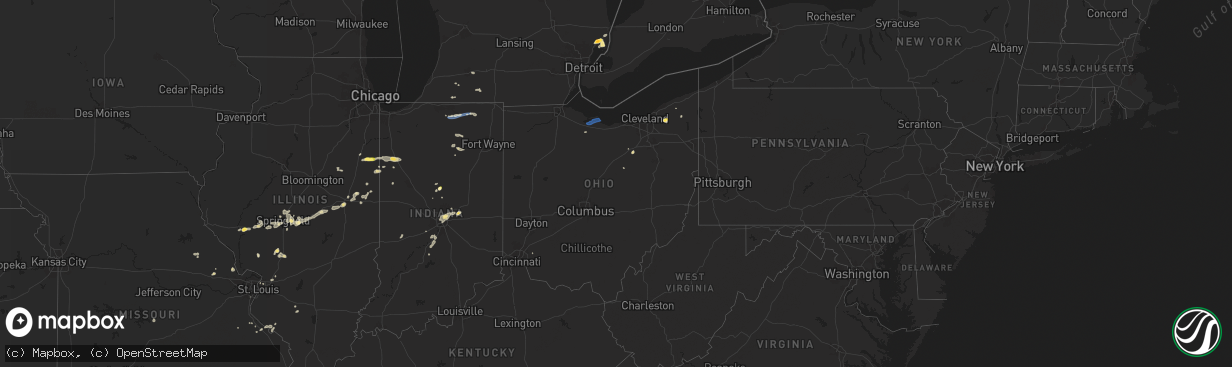
Hail Map in Ohio on August 30, 2024
The weather event in Ohio on August 30, 2024 includes Hail, Wind, and Tornado maps. 17 states and 337 cities were impacted and suffered possible damage. The total estimated number of properties impacted is 1,032.
Want more than just the map?
Turn this storm into a full workflow.
- Owner + property data so you know who to knock
- OnDemand branded weather history reports to win the "did we even have hail?" argument
- RoofTrace estimate so reps stop guessing numbers at the door
Bought this map? Upgrade within 7 days and we'll credit the $230. (10-15 min setup call)
Hail
Wind
Tornado
1,032
Estimated number of impacted properties by a 1.00" hail or larger0
Estimated number of impacted properties by a 1.75" hail or larger0
Estimated number of impacted properties by a 2.50" hail or largerStorm reports in Ohio
Ohio
| Date | Description |
|---|---|
| 08/30/20245:14 PM CDT | Large tree snapped and fell down onto vehicle. |
| 08/30/20244:47 PM CDT | A power line was downed and on fire in hubbard township. Time estimated from radar. |
| 08/30/20244:45 PM CDT | Tree down blocking a road in weathersfield township. Time estimated from radar. |
| 08/30/20244:18 PM CDT | Tree fell and took down a power line. The road is closed in the area. Time estimated from radar. |
| 08/30/20244:16 PM CDT | Tree fell and took down a power line in bezetta township closing the road. Time estimated from radar. |
| 08/30/20244:12 PM CDT | Tree blown down onto hubbard valley road. Report via police scanner. Time estimated from radar. |
| 08/30/20244:11 PM CDT | Multiple trees and wires down throughout the town of seville via police scanner. Time estimated from radar. |
| 08/30/20244:10 PM CDT | Blown transformer and wires down on wooster pike. Report heard via police scanner. Time estimated from radar. |
| 08/30/20244:10 PM CDT | Trees downed. Report from mping. Time estimated from radar. |
| 08/30/20244:07 PM CDT | Trees downed. Report from mping. Time estimated from radar. |
| 08/30/20244:00 PM CDT | Power lines down on easton road. Report heard via police scanner. Time estimated from radar. |
| 08/30/20243:42 PM CDT | Minor roof damage to home on oak street. Time estimated from radar data. |
| 08/30/20243:30 PM CDT | A few trees down along woodville pike. An additional tree leaning on wires. Time estimated from radar data. |
| 08/30/20242:58 PM CDT | Multiple trees down on state route 44 closing the road. Report heard via police scanner. |
| 08/30/20242:58 PM CDT | Tree down at the corner of state route 44 and bell street. Time estimated from radar. |
| 08/30/20242:44 PM CDT | *** 1 inj *** two trees fell on two separate houses in the same area. Time estimated from radar data. |
| 08/30/20242:44 PM CDT | Tree down. |
| 08/30/20242:10 PM CDT | Social media photos showing numerous large healthy branches downed... Snapped pine trees... And thrown yard debris throughout somerford township. |
| 08/30/20241:54 PM CDT | Several trees downed near the intersection of us route 40 and state route 56. Time estimated from radar. |
| 08/30/20241:45 AM CDT | Delayed report. Report of tree split and down on perry st. Time estimated by radar. |
All States Impacted by Hail Map on August 30, 2024
Cities Impacted by Hail Map on August 30, 2024
- Alpharetta, GA
- Roswell, GA
- Sainte Genevieve, MO
- Hohenwald, TN
- Lake Toxaway, NC
- Modoc, IL
- Ellis Grove, IL
- Chester, IL
- Como, NC
- Morrisville, NC
- Raleigh, NC
- Newport, NC
- Perryville, MO
- Bonne Terre, MO
- Murfreesboro, NC
- Knightdale, NC
- Mcminnville, TN
- Wake Forest, NC
- Laurel Fork, VA
- Weaverville, NC
- Walsh, IL
- Wendell, NC
- Chapel Hill, NC
- Durham, NC
- Ball Ground, GA
- Greensboro, GA
- Hendersonville, NC
- Fletcher, NC
- Almond, NC
- Horse Shoe, NC
- Mills River, NC
- Centre, AL
- Troy, SC
- Sautee Nacoochee, GA
- Pittsboro, NC
- Cleveland, GA
- Graham, NC
- Carrboro, NC
- Nashville, IL
- Old Fort, NC
- Marion, NC
- Bassett, VA
- Newbury, OH
- Chagrin Falls, OH
- Novelty, OH
- Litchfield, IL
- Morganton, NC
- Clifton, TN
- Du Bois, IL
- Winchester, IL
- Snow Camp, NC
- Burton, OH
- Vanceboro, NC
- Warrenton, MO
- Elko, GA
- Pittsfield, IL
- Bath Springs, TN
- Zebulon, NC
- New Hill, NC
- Nebo, NC
- Butler, IL
- Bloomington, IN
- Decaturville, TN
- Ernul, NC
- Rock Creek, OH
- Marietta, SC
- Orwell, OH
- Carlinville, IL
- Goshen, OH
- Liberty, NC
- Dugspur, VA
- Chardon, OH
- Nilwood, IL
- Raymond, IL
- Chatham, IL
- New Berlin, IL
- Snow Hill, NC
- Jacksonville, IL
- Buena Vista, GA
- Ellaville, GA
- Calhoun, GA
- Adairsville, GA
- Medora, IL
- Ellery, IL
- Riner, VA
- Vina, AL
- Hamilton, AL
- Edwardsville, IL
- Saint Louis, MO
- Wooster, OH
- Creston, OH
- Springfield, IL
- Odonnell, TX
- Lakeville, OH
- Alexander, IL
- Burbank, OH
- West Salem, OH
- Alhambra, IL
- La Grange, NC
- Sherman, IL
- Williamsville, IL
- Ozona, TX
- Pink Hill, NC
- Trenton, NC
- Granite City, IL
- Tahoka, TX
- Winfield, MO
- Old Monroe, MO
- Farber, MO
- Vandalia, MO
- Laddonia, MO
- La Fayette, GA
- Kalamazoo, MI
- Galesburg, MI
- Cherokee, AL
- Tremont, MS
- Commerce, GA
- Jefferson, GA
- Middletown, MO
- Saint Joseph, TN
- Marine, IL
- Summerville, GA
- Athens, TN
- Scotts, MI
- Largo, FL
- Seminole, FL
- Gillespie, IL
- Riceville, TN
- Floyd, VA
- Hillsboro, IL
- Decatur, TN
- High Point, NC
- Georgetown, TN
- Cassopolis, MI
- Seven Springs, NC
- Loami, IL
- Greensboro, NC
- Jamestown, NC
- Marcellus, MI
- Watseka, IL
- Raeford, NC
- Forrest, IL
- Strawn, IL
- Vandalia, MI
- Jones, MI
- Crescent City, IL
- Ashkum, IL
- Gilman, IL
- Atlanta, GA
- Canon, GA
- Squire, WV
- Bandy, VA
- Royston, GA
- Kernersville, NC
- Winston Salem, NC
- Cropsey, IL
- Mendon, MI
- Colon, MI
- Fairburn, GA
- Colfax, NC
- Sheldon, IL
- Hookerton, NC
- Gail, TX
- Bronson, MI
- Grifton, NC
- Kinston, NC
- Douglasville, GA
- Nappanee, IN
- Wakarusa, IN
- Goshen, IN
- New Paris, IN
- Millersburg, IN
- Palmetto, GA
- Milford, IL
- Berea, KY
- Dawson, IL
- Mechanicsburg, IL
- Edinburg, IL
- Riverton, IL
- Rochester, IL
- Elberton, GA
- Buffalo, IL
- Mount Auburn, IL
- Stockland, IL
- Fowler, IN
- Hartwell, GA
- Brook, IN
- Kentland, IN
- Goodland, IN
- Polk, PA
- Utica, PA
- Ellerbe, NC
- Rockingham, NC
- Mount Gilead, NC
- McGrady, NC
- Remington, IN
- Topeka, IN
- Ligonier, IN
- Galax, VA
- Lilesville, NC
- Hixson, TN
- Soddy Daisy, TN
- Rensselaer, IN
- McKee, KY
- Blue Mound, IL
- Richmond, KY
- Illiopolis, IL
- Hamlet, NC
- Marston, NC
- Garland, NC
- Waverly, IL
- Iroquois, IL
- Ulman, MO
- Brumley, MO
- Pleasant Garden, NC
- Wolcott, IN
- Ambia, IN
- New Baltimore, MI
- New Haven, MI
- Casco, MI
- Fayetteville, NC
- Donovan, IL
- Wolcottville, IN
- Lagrange, IN
- Tyner, KY
- Argenta, IL
- Morgantown, KY
- Decatur, IL
- Niantic, IL
- Rossville, IL
- Rankin, IL
- Saint Joseph, IL
- Charlotte, NC
- Peachland, NC
- Marshville, NC
- Monticello, IL
- Cisco, IL
- Milmine, IL
- Oreana, IL
- Cerro Gordo, IL
- Gifford, IL
- Urbana, IL
- Ogden, IL
- Penfield, IL
- Thomasboro, IL
- Ivesdale, IL
- White Heath, IL
- Marine City, MI
- Fair Haven, MI
- East China, MI
- Champaign, IL
- Savoy, IL
- Saint Clair, MI
- Matthews, NC
- Earl Park, IN
- Silver Lake, IN
- Algonac, MI
- Albertson, NC
- Bessemer City, NC
- Seymour, IL
- Collison, IL
- Danville, IL
- Potomac, IL
- Alvin, IL
- Fithian, IL
- North Manchester, IN
- Hoopeston, IL
- Gastonia, NC
- Belmont, NC
- Tolono, IL
- Kings Mountain, NC
- Armstrong, IL
- Oakwood, IL
- Martinsville, IN
- Loveland, OH
- Versailles, KY
- Lexington, KY
- Homer, IL
- Morgantown, IN
- Reelsville, IN
- Brazil, IN
- Pine Village, IN
- Kempton, IN
- Tipton, IN
- Sharpsville, IN
- Winona Lake, IN
- Pierceton, IN
- Warsaw, IN
- Roaring River, NC
- Traphill, NC
- North Wilkesboro, NC
- Columbia, KY
- Travelers Rest, SC
- Mooresville, IN
- Sheridan, IN
- Magnolia, NC
- Kenansville, NC
- Beulaville, NC
- Indianapolis, IN
- Rosedale, VA
- Lebanon, VA
- Millers Creek, NC
- Hays, NC
- Troutdale, VA
- Independence, VA
- Mccordsville, IN
- Fortville, IN
- Arcadia, IN
- Greenfield, IN
- Pendleton, IN
- Fort Mill, SC
- Lancaster, SC
- Clayton, IN
- Wabash, IN
- York, SC
- Winterville, NC
- Pikeville, NC
- Farmville, NC
- Festus, MO
- Bloomsdale, MO
- Hawk Point, MO
- Sandy Lake, PA
- Sibley, IL
- Pawnee, IL
- Frankfort, IN
- Russiaville, IN
- Kokomo, IN
- Clyde, OH
- Fremont, OH
- Green Springs, OH
- Bellevue, OH
- Vickery, OH
- Castalia, OH
- Sandusky, OH
- Noblesville, IN
- Fishers, IN
- Carlton, PA


