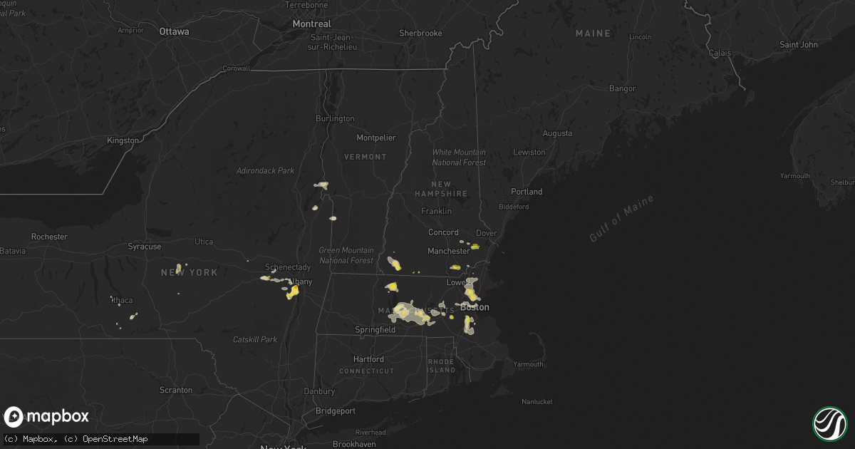
Hail Map in New Hampshire on August 23, 2020
Get this storm
August 23 map
$229
one time, instant access
Download today. No call, no setup
Keep the $229
Bought the map and want the full workflow? Apply the entire $229 to a subscription within 7 days. None of it is wasted.
Every map, not just this one
This buys you this map. Subscription and you get every map we run, in the markets you choose from a few cities to whole states to nationwide. Plus real-time alerts the moment a storm fires.
Contact data
Name, contact info, occupancy, even credit band for addresses in the footprint. You go from where it hit to who to call.
Become the source they trust
Unlimited branding weather history reports on demand. You already have the documented answer ready for the property owner, and you are the one who showed up with it.
Property data and RoofTrace estimates
Pull up any address you have got, its value and the exact code rules for that jurisdiction, straight from One Click Code. Then RoofTrace estimates the squares, pitch, and roof value, priced the way you price.
Storm reports in New Hampshire
New Hampshire
| Date | Description |
|---|---|
| 08/23/20202:30 PM CDT | Trees and wires down. |
| 08/23/20202:20 PM CDT | Trees and wires down. |
| 08/23/20202:20 PM CDT | Multiple trees and wires down. Reported at west hollis street nashua nh. |
| 08/23/20202:20 PM CDT | *** 6 inj *** thunderstorm blew over a tent where may people gathered an injured at least 6 people. Injuries did not appear to be life threatening. |
| 08/23/20201:55 PM CDT | Trees down. |
| 08/23/20201:50 PM CDT | Multiple trees and wires down. Reported at eaton road pittsfield nh. |
| 08/23/20201:50 PM CDT | Trees and wires down. |
| 08/23/20201:50 PM CDT | Trees and wires down. Reported at loudon road pittsfield nh. |
| 08/23/20201:35 PM CDT | Trees and wires down. Reported at jaffery road marlboro nh. |
| 08/23/20201:30 PM CDT | Road blocked by downed trees and wires. Reported at central square road troy nh. |
| 08/23/20201:25 PM CDT | Multiple trees and wires down. Reported at oliver hill road swanzey nh. |
| 08/23/20201:25 PM CDT | 20 sections of wires down. |
| 08/23/20201:25 PM CDT | Wires down. Reported at taff road swanzey nh. |
| 08/23/20201:25 PM CDT | Multiple trees down. Wires down also. |
| 08/23/20201:15 PM CDT | A local report indicates 1.00 inch wind near WINDHAM |
| 08/23/20203:30 AM CDT | At 829 PM EDT, severe thunderstorms were located along a line extending from Bridgewater Corners to near North Chester, moving east at 30 mph. HAZARD...60 mph wind gusts and quarter size hail. SOURCE...Radar indicated. IMPACT...Minor hail damage to vehicles is possible. Expect wind damage to trees and powerlines. Locations impacted include... Woodstock, Chester, Hartland Four Corners, Windsor, Woodstock Village, Cavendish, Perkinsville Village, Hartland, Bridgewater, Reading, Baltimore, Springfield, Weathersfield, West Windsor, Hartford, Plymouth, Perkinsville, Felchville, Brownsville and North Hartland Dam Recreation Area. |
| 08/23/20203:16 AM CDT | At 815 PM EDT, a severe thunderstorm was located near Keene, moving southeast at 10 mph. HAZARD...60 mph wind gusts and quarter size hail. SOURCE...Radar indicated. IMPACT...Hail damage to vehicles is expected. Expect wind damage to roofs, siding, and trees. Locations impacted include... Keene, Swanzey, Winchester, Richmond, Marlborough, Troy, Chesterfield and Westmoreland. |
| 08/22/202010:47 PM CDT | At 346 PM EDT, a severe thunderstorm was located over Phillipston, or 9 miles southeast of Orange, moving east at 15 mph. There are also several other storms stretching into northeast MA that may result in pockets of wind damage. HAZARD...60 mph wind gusts and quarter size hail. SOURCE...Radar indicated. IMPACT...Expect wind damage to trees and power lines. Minor hail damage to vehicles is possible. Locations impacted include... Lowell, Lawrence, Haverhill, Peabody, Methuen, Leominster, Fitchburg, Billerica, Beverly, Woburn, Chelmsford, Andover, Dracut, Tewksbury, Gloucester, North Andover, Danvers, Orange, Reading and Burlington. |
| 08/22/202010:16 PM CDT | At 316 PM EDT, a severe thunderstorm was located over New Ipswich, or 11 miles southeast of Jaffrey, moving east at 15 mph. HAZARD...60 mph wind gusts and nickel size hail. SOURCE...Radar indicated. IMPACT...Expect damage to roofs, siding, and trees. Locations impacted include... Nashua, Hollis, Brookline, Mason, Greenville, New Ipswich and Rindge. |
| 08/22/202010:14 PM CDT | At 313 PM EDT, a severe thunderstorm was located over Athol, or near Orange, moving east at 15 mph. HAZARD...60 mph wind gusts and quarter size hail. SOURCE...Radar indicated. IMPACT...Expect wind damage to trees and power lines. Minor hail damage to vehicles is possible. Locations impacted include... Lowell, Fitchburg, Chelmsford, Andover, Dracut, Tewksbury, Orange, Westford, Gardner, Athol, Pepperell, Tyngsborough, Groton, Winchendon, Lunenburg, Townsend, Templeton, Westminster, Shirley and Ashburnham. |
| 08/22/20209:21 PM CDT | At 221 PM EDT, a severe thunderstorm was located over Wendell, or near Orange, moving east at 15 mph. HAZARD...60 mph wind gusts and quarter size hail. SOURCE...Radar indicated. IMPACT...Expect wind damage to trees and power lines. Minor hail damage to vehicles is possible. Locations impacted include... Orange, Gardner, Athol, Winchendon, Montague, Templeton, Barre, Hubbardston, Northfield, Leverett, Erving, Shutesbury, Phillipston, Gill, Royalston, Petersham, New Salem, Wendell and Warwick. |
| 08/22/20208:56 PM CDT | At 154 PM EDT, a cluster of severe thunderstorms was located near Hooksett, or near Auburn, moving east at 15 mph. HAZARD...60 mph wind gusts and penny size hail. SOURCE...Radar indicated. IMPACT...Expect damage to roofs, siding, and trees. Locations impacted include... Northwood, Hooksett, Barrington, Epping, Epsom, Brentwood, Raymond, Chester, Lee, Allenstown, Fremont, Deerfield, Candia, Madbury, Nottingham, Pembroke and Strafford. |
| 08/22/20208:00 PM CDT | Tree down across the road. |
| 08/22/20207:55 PM CDT | Trees and wires down. Reported at oxbrook road charlestown nh. |
| 08/22/20207:25 PM CDT | Corrects previous tstm wnd dmg report from 3 wsw keene. Tree down across chesterfield rd. Time estimated from radar. Delayed report. Corrected to change source to law e |
All States Impacted by Hail Map on August 23, 2020
Cities Impacted by Hail Map on August 23, 2020
- Owanka, SD
- Wasta, SD
- Tappen, ND
- Ypsilanti, ND
- Valley City, ND
- Baldwin, ND
- Streeter, ND
- Napoleon, ND
- Fort Ransom, ND
- Lisbon, ND
- Verona, ND
- Medina, ND
- Jud, ND
- Marion, ND
- Montpelier, ND
- Jamestown, ND
- Steele, ND
- Litchville, ND
- Pettibone, ND
- Driscoll, ND
- Pingree, ND
- Dawson, ND
- Tuttle, ND
- Gackle, ND
- Sterling, ND
- Cleveland, ND
- Spiritwood, ND
- Robinson, ND
- Sanborn, ND
- Kintyre, ND
- Wing, ND
- Regan, ND
- Woodworth, ND
- Faith, SD
- Mud Butte, SD
- Union Center, SD
- Palatine, IL
- Rolling Meadows, IL
- Arlington Heights, IL
- Sutton, MA
- Dumont, MN
- Chokio, MN
- Menomonee Falls, WI
- Milwaukee, WI
- Butler, WI
- Selkirk, NY
- Fairmount, ND
- Hankinson, ND
- Tuthill, SD
- Martin, SD
- Allen, SD
- Hackberry, AZ
- Oakes, ND
- Ellendale, ND
- Brockton, MA
- Dedham, MA
- South Easton, MA
- Foxboro, MA
- North Easton, MA
- Norwood, MA
- Sharon, MA
- East Walpole, MA
- Stoughton, MA
- Westwood, MA
- Canton, MA
- Worcester, MA
- Millbury, MA
- Auburn, MA
- Pekin, IL
- Tremont, IL
- Buchanan, ND
- Raymond, MN
- Willmar, MN
- Pennock, MN
- Kerkhoven, MN
- Londonderry, NH
- Hudson, NH
- Windham, NH
- Clinton, MN
- Corona, SD
- Ortonville, MN
- Edgeley, ND
- Spencer, MA
- Paxton, MA
- Leicester, MA
- Holden, MA
- Cherry Valley, MA
- Winchester, NH
- Swanzey, NH
- Forbes, ND
- Caputa, SD
- Rapid City, SD
- White River, SD
- Danvers, MN
- Hancock, MN
- Granite Falls, MN
- Maynard, MN
- Montevideo, MN
- Cuervo, NM
- New Underwood, SD
- Waubay, SD
- Webster, SD
- Frederick, SD
- Leola, SD
- Beardsley, MN
- Spencer, NY
- Newfield, NY
- Ithaca, NY
- Prescott, AZ
- Sacred Heart, MN
- Erving, MA
- Orange, MA
- Wendell, MA
- Wendell Depot, MA
- Box Elder, SD
- Correll, MN
- Appleton, MN
- Las Cruces, NM
- Hazelton, ND
- Moffit, ND
- Seligman, AZ
- Wood, SD
- Summit, SD
- Kulm, ND
- Cogswell, ND
- Alberta, MN
- Morris, MN
- Wheaton, MN
- Donnelly, MN
- Odessa, MN
- Dawson, MN
- Milan, MN
- Benson, MN
- Madison, MN
- Graceville, MN
- Clontarf, MN
- Holloway, MN
- Las Vegas, NV
- House, NM
- West Pawlet, VT
- Claire City, SD
- Pierpont, SD
- Elmer, NJ
- Danube, MN
- Renville, MN
- Cosmos, MN
- Lake Lillian, MN
- Blomkest, MN
- Hector, MN
- Hutchinson, MN
- Atwater, MN
- Stewart, MN
- Buffalo Lake, MN
- Fullerton, ND
- Roslyn, SD
- Andover, SD
- Braddock, ND
- Ware, MA
- Hardwick, MA
- Coeymans Hollow, NY
- Glenmont, NY
- Feura Bush, NY
- Alcove, NY
- Hannacroix, NY
- South Bethlehem, NY
- Ravena, NY
- Delmar, NY
- Wilmington, MA
- Wakefield, MA
- Saugus, MA
- Melrose, MA
- Woburn, MA
- Winchester, MA
- Medford, MA
- Malden, MA
- Stoneham, MA
- Reading, MA
- Burlington, MA
- Olivia, MN
- Happy Jack, AZ
- New Braintree, MA
- West Brookfield, MA
- North Brookfield, MA
- Milton, MA
- Mansfield, MA
- Walpole, MA
- Hyde Park, MA
- Putnam Station, NY
- Fair Haven, VT
- Melrose, NM
- Voorheesville, NY
- Westerlo, NY
- Clarksville, NY
- East Berne, NY
- Middle River, MD
- Essex, MD
- Warren, MA
- Gilbertville, MA
- Fremont, NH
- Epping, NH
- Exeter, NH
- Northborough, MA
- Shrewsbury, MA
- Westborough, MA
- Wimbledon, ND
- Brownsville, VT
- Windsor, VT
- Gwinner, ND
- Winner, SD
- Elm Grove, WI
- Brookfield, WI
- Fort Sumner, NM
- Gurnee, IL
- Middletown Springs, VT
- Lincolnshire, IL
- Lake Bluff, IL
- Highwood, IL
- Northbrook, IL
- Highland Park, IL
- Deerfield, IL
- Great Lakes, IL
- Wheeling, IL
- Lake Forest, IL
- Buffalo Grove, IL
- Willseyville, NY
- Candor, NY
- Morocco, IN
- Lake Village, IN
- Fair Oaks, IN
- Oral, SD
- New Berlin, WI
- Newfields, NH
- Bridgeton, NJ
- Sherborn, MA
- Holliston, MA
- Ashland, MA
- Milnor, ND
- Chester, VT
- Saint Anne, IL
- Pembroke Township, IL
- Lamoure, ND
- Randolph, MA
- Belchertown, MA
- Lockwood, NY
- Hoffman Estates, IL
- Schaumburg, IL
- New Ipswich, NH
- Fort Ann, NY
- Whitehall, NY
- Sisseton, SD
- Schoharie, NY
- Overton, NV
- Mercer, ND
- Momence, IL
- Delanson, NY
- Southborough, MA
- Bristol, SD
- Groton, SD
- New Salem, MA
- Athol, MA
- Warwick, MA
- Hopkinton, MA
- Candia, NH
- Deerfield, NH
- Kirkland, AZ
- Hamilton, NY
- Britton, SD
- Canajoharie, NY
- Coleharbor, ND
- Duanesburg, NY
- Okaton, SD
- Millville, NJ
- Cedarville, NJ
- Dickey, ND
- Big Stone City, SD
- Watson, MN
- Wells, VT
- Granville, NY
- North Andover, MA
- Andover, MA
- Hudson, MA
- East Boston, MA
- Boston, MA
- Wayland, MA
- Waltham, MA
- Weston, MA
- Brighton, MA
- Cambridge, MA
- Lincoln, MA
- Watertown, MA
- Lexington, MA
- Arlington, MA
- Charlestown, MA
- Chelsea, MA
- Allston, MA
- Belmont, MA
- Willow Beach, AZ
- Palmer, MA
- Berlin, MA
- Marlborough, MA
- Stow, MA
- Albert Lea, MN
- Barre, MA
- Bondsville, MA
- Grafton, MA
- Brookfield, MA
- Rutland, MA
- Charlton, MA
- Jefferson, MA
- Rochdale, MA
- Oakham, MA
- North Oxford, MA
- East Brookfield, MA
- South Barre, MA
- South Grafton, MA
- Oxford, MA
- Thorndike, MA
- Kathryn, ND
- Libertyville, IL
- Grayslake, IL
- Cavendish, VT
- Perkinsville, VT
- Keene, NH
- Howes Cave, NY
- Berne, NY
- Lake Zurich, IL
- Vernon Hills, IL
- Crown King, AZ
- Elk Grove Village, IL
- Raymond, NH
- Nottingham, NH
- Atkinson, NH
- Haverhill, MA
- Canton, IL
- Cuba, IL
- Troy, NH
- Spofford, NH
- Earlville, NY
- Eaton, NY
- Trumansburg, NY
- Revere, MA
- North Reading, MA
- Lynnfield, MA
- Lawrence, MA
- Tewksbury, MA
- Boxford, MA
- Lynn, MA
- Oxford, NY
- Mount Prospect, IL
- Prospect Heights, IL
- Slingerlands, NY
- Altamont, NY
- Murdo, SD
- Belvidere, SD
- Midland, SD
- Kingman, AZ
- Springfield, VT
- Saint George, UT
- Smyrna, NY
- Dundalk, MD
- Baltimore, MD
- Rosedale, MD
- Globe, AZ
- Orwell, VT
- Hague, NY
- Silver Bay, NY
- Framingham, MA
- Bismarck, ND
- Stirum, ND
- Ortley, SD
- Kandiyohi, MN
- Murdock, MN
- Philip, SD
- Quinn, SD
- Wall, SD
- Albany, NY
- Rindge, NH


