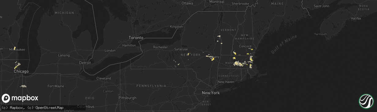
Hail Map in New York on August 23, 2020
The weather event in New York on August 23, 2020 includes Hail and Wind maps. 16 states and 377 cities were impacted and suffered possible damage. The total estimated number of properties impacted is 2,849.
Want more than just the map?
Turn this storm into a full workflow.
- Owner + property data so you know who to knock
- OnDemand branded weather history reports to win the "did we even have hail?" argument
- RoofTrace estimate so reps stop guessing numbers at the door
Bought this map? Upgrade within 7 days and we'll credit the $230. (10-15 min setup call)
Hail
Wind
2,849
Estimated number of impacted properties by a 1.00" hail or larger0
Estimated number of impacted properties by a 1.75" hail or larger0
Estimated number of impacted properties by a 2.50" hail or largerStorm reports in New York
New York
| Date | Description |
|---|---|
| 08/23/20204:00 PM CDT | A local report indicates 1.00 inch wind near 4 SSW DELANSON |
| 08/23/20203:59 PM CDT | Downed limbs on larry hill road near kump road |
| 08/23/20203:55 PM CDT | Large tree down near state hwy 5s and canajoharie... Ny. |
| 08/23/20203:10 PM CDT | A local report indicates 1.00 inch wind near 3 W HAMILTON |
| 08/23/20202:49 PM CDT | Trees down on 1716 rt 143 in coeyman... Ny. |
| 08/23/20202:46 PM CDT | Barn roof torn off |
| 08/23/20202:27 PM CDT | Fire due to tree on wires |
| 08/23/20202:21 PM CDT | Trees down blocking road |
| 08/23/20202:16 PM CDT | Trees uprooted |
| 08/23/20202:13 PM CDT | Tree and wires down |
| 08/23/20202:12 PM CDT | Trees down on 1716 rt 143 in coeyman... Ny. |
| 08/23/20201:48 PM CDT | 0.5 to 1.5 inch hail reported |
| 08/23/20201:43 PM CDT | A local report indicates 1.00 inch wind near 2 WSW HAMPTON MANOR |
| 08/23/20201:42 PM CDT | Quarter size hail on elm ave. And feura bush rd. |
| 08/23/202012:30 PM CDT | Trees and wires down |
| 08/23/20207:48 AM CDT | At 1248 PM EDT, a severe thunderstorm was located near Lockwood, or 8 miles north of Waverly, moving northeast at 15 mph. HAZARD...60 mph wind gusts and quarter size hail. SOURCE...Radar indicated. IMPACT...Hail damage to vehicles is expected. Expect wind damage to roofs, siding, and trees. Locations impacted include... Owego, Candor, Catatonk, Weltonville and West Candor. |
| 08/22/202011:53 PM CDT | At 453 PM EDT, a severe thunderstorm was located over Canajoharie, moving east at 20 mph. HAZARD...60 mph wind gusts and quarter size hail. SOURCE...Radar indicated. IMPACT...Hail damage to vehicles is expected. Expect wind damage to roofs, siding, and trees. Locations impacted include... Amsterdam, Canajoharie, Fonda, Hagaman, Fort Johnson, Ames, Tribes Hill, Glen, Charleston, Fultonville, Palatine Bridge, Nelliston, Auriesville, Marshville, Cook Corners, Sprakers, Scotch Bush, Flat Creek, Young Corners and Lost Valley. |
| 08/22/202011:43 PM CDT | At 443 PM EDT, a severe thunderstorm was located near Schoharie, or 11 miles east of Cobleskill, moving east at 10 mph. HAZARD...60 mph wind gusts and quarter size hail. SOURCE...Radar indicated. IMPACT...Hail damage to vehicles is expected. Expect wind damage to roofs, siding, and trees. Locations impacted include... Berne, Altamont, Schoharie, Delanson, Central Bridge, Knox, East Berne, Old Central Bridge, West Berne, Old Stone Fort, Quaker Street, Dunnsville, Helderberg, Sidney Corners, West Township, Bensons Corners, Thompsons Lake, Vroman Corners, East Township and Thatcher State Park. |
| 08/22/202010:54 PM CDT | At 354 PM EDT, a severe thunderstorm was located over South Lebanon, or near Hamilton, moving east at 15 mph. HAZARD...60 mph wind gusts and quarter size hail. SOURCE...Radar indicated. IMPACT...Hail damage to vehicles is expected. Expect wind damage to roofs, siding, and trees. Locations impacted include... Hamilton, Brookfield, Sherburne, Lebanon, New Berlin, Columbus, Earlville, Smyrna, Poolville and South Lebanon. |
| 08/22/202010:47 PM CDT | At 347 PM EDT, a severe thunderstorm was located near Ravena, or 9 miles southwest of Delmar, moving west at 5 mph. HAZARD...60 mph wind gusts and quarter size hail. SOURCE...Radar indicated. IMPACT...Hail damage to vehicles is expected. Expect wind damage to roofs, siding, and trees. Locations impacted include... Ravena, Coeymans, Coeymans Hollow, Aquetuck, South Bethlehem, Bethlehem Heights, Roah Hook, Spawn Hollow and Callanans Corners. |
| 08/22/202010:08 PM CDT | At 308 PM EDT, a severe thunderstorm was located over Selkirk, or near Delmar, moving southeast at 10 mph. HAZARD...60 mph wind gusts and quarter size hail. SOURCE...Radar indicated. IMPACT...Hail damage to vehicles is expected. Expect wind damage to roofs, siding, and trees. Locations impacted include... Ravena, Coeymans, Coeymans Hollow, Aquetuck, South Bethlehem, Bethlehem Heights, Muitzes Kill, Roah Hook, Spawn Hollow, Callanans Corners and Schodack Landing. |
| 08/22/20209:39 PM CDT | At 239 PM EDT, a severe thunderstorm was located near Selkirk, or near Delmar, and is nearly stationary. HAZARD...60 mph wind gusts and penny size hail. SOURCE...Radar indicated. IMPACT...Expect damage to roofs, siding, and trees. Locations impacted include... East Greenbush, Rensselaer, Nassau, Delmar, Castleton-On-Hudson, Averill Park, West Sand Lake, Selkirk, Feura Bush, East Schodack, Brookview, Van Hoesen Station, South Albany, Selkirk Yards, Beckers Corners, East Greenbush Station, South Schodack, Meyers Corners, Cedar Hill and Houcks Corners. |
| 08/22/20208:25 PM CDT | At 125 PM EDT, a severe thunderstorm was located over Candor, or 11 miles north of Owego, moving northeast at 20 mph. HAZARD...60 mph wind gusts and quarter size hail. SOURCE...Radar indicated. IMPACT...Hail damage to vehicles is expected. Expect wind damage to roofs, siding, and trees. Locations impacted include... Caroline, Nanticoke, Berkshire, Richford, Newark Valley, Candor, Willseyville, Jenksville, Center Lisle and Speedville. |
| 08/22/20207:45 PM CDT | Trees and wires down on route 9n near rogers rock campground |
All States Impacted by Hail Map on August 23, 2020
Cities Impacted by Hail Map on August 23, 2020
- Owanka, SD
- Wasta, SD
- Tappen, ND
- Ypsilanti, ND
- Valley City, ND
- Baldwin, ND
- Streeter, ND
- Napoleon, ND
- Fort Ransom, ND
- Lisbon, ND
- Verona, ND
- Medina, ND
- Jud, ND
- Marion, ND
- Montpelier, ND
- Jamestown, ND
- Steele, ND
- Litchville, ND
- Pettibone, ND
- Driscoll, ND
- Pingree, ND
- Dawson, ND
- Tuttle, ND
- Gackle, ND
- Sterling, ND
- Cleveland, ND
- Spiritwood, ND
- Robinson, ND
- Sanborn, ND
- Kintyre, ND
- Wing, ND
- Regan, ND
- Woodworth, ND
- Faith, SD
- Mud Butte, SD
- Union Center, SD
- Palatine, IL
- Rolling Meadows, IL
- Arlington Heights, IL
- Sutton, MA
- Dumont, MN
- Chokio, MN
- Menomonee Falls, WI
- Milwaukee, WI
- Butler, WI
- Selkirk, NY
- Fairmount, ND
- Hankinson, ND
- Tuthill, SD
- Martin, SD
- Allen, SD
- Hackberry, AZ
- Oakes, ND
- Ellendale, ND
- Brockton, MA
- Dedham, MA
- South Easton, MA
- Foxboro, MA
- North Easton, MA
- Norwood, MA
- Sharon, MA
- East Walpole, MA
- Stoughton, MA
- Westwood, MA
- Canton, MA
- Worcester, MA
- Millbury, MA
- Auburn, MA
- Pekin, IL
- Tremont, IL
- Buchanan, ND
- Raymond, MN
- Willmar, MN
- Pennock, MN
- Kerkhoven, MN
- Londonderry, NH
- Hudson, NH
- Windham, NH
- Clinton, MN
- Corona, SD
- Ortonville, MN
- Edgeley, ND
- Spencer, MA
- Paxton, MA
- Leicester, MA
- Holden, MA
- Cherry Valley, MA
- Winchester, NH
- Swanzey, NH
- Forbes, ND
- Caputa, SD
- Rapid City, SD
- White River, SD
- Danvers, MN
- Hancock, MN
- Granite Falls, MN
- Maynard, MN
- Montevideo, MN
- Cuervo, NM
- New Underwood, SD
- Waubay, SD
- Webster, SD
- Frederick, SD
- Leola, SD
- Beardsley, MN
- Spencer, NY
- Newfield, NY
- Ithaca, NY
- Prescott, AZ
- Sacred Heart, MN
- Erving, MA
- Orange, MA
- Wendell, MA
- Wendell Depot, MA
- Box Elder, SD
- Correll, MN
- Appleton, MN
- Las Cruces, NM
- Hazelton, ND
- Moffit, ND
- Seligman, AZ
- Wood, SD
- Summit, SD
- Kulm, ND
- Cogswell, ND
- Alberta, MN
- Morris, MN
- Wheaton, MN
- Donnelly, MN
- Odessa, MN
- Dawson, MN
- Milan, MN
- Benson, MN
- Madison, MN
- Graceville, MN
- Clontarf, MN
- Holloway, MN
- Las Vegas, NV
- House, NM
- West Pawlet, VT
- Claire City, SD
- Pierpont, SD
- Elmer, NJ
- Danube, MN
- Renville, MN
- Cosmos, MN
- Lake Lillian, MN
- Blomkest, MN
- Hector, MN
- Hutchinson, MN
- Atwater, MN
- Stewart, MN
- Buffalo Lake, MN
- Fullerton, ND
- Roslyn, SD
- Andover, SD
- Braddock, ND
- Ware, MA
- Hardwick, MA
- Coeymans Hollow, NY
- Glenmont, NY
- Feura Bush, NY
- Alcove, NY
- Hannacroix, NY
- South Bethlehem, NY
- Ravena, NY
- Delmar, NY
- Wilmington, MA
- Wakefield, MA
- Saugus, MA
- Melrose, MA
- Woburn, MA
- Winchester, MA
- Medford, MA
- Malden, MA
- Stoneham, MA
- Reading, MA
- Burlington, MA
- Olivia, MN
- Happy Jack, AZ
- New Braintree, MA
- West Brookfield, MA
- North Brookfield, MA
- Milton, MA
- Mansfield, MA
- Walpole, MA
- Hyde Park, MA
- Putnam Station, NY
- Fair Haven, VT
- Melrose, NM
- Voorheesville, NY
- Westerlo, NY
- Clarksville, NY
- East Berne, NY
- Middle River, MD
- Essex, MD
- Warren, MA
- Gilbertville, MA
- Fremont, NH
- Epping, NH
- Exeter, NH
- Northborough, MA
- Shrewsbury, MA
- Westborough, MA
- Wimbledon, ND
- Brownsville, VT
- Windsor, VT
- Gwinner, ND
- Winner, SD
- Elm Grove, WI
- Brookfield, WI
- Fort Sumner, NM
- Gurnee, IL
- Middletown Springs, VT
- Lincolnshire, IL
- Lake Bluff, IL
- Highwood, IL
- Northbrook, IL
- Highland Park, IL
- Deerfield, IL
- Great Lakes, IL
- Wheeling, IL
- Lake Forest, IL
- Buffalo Grove, IL
- Willseyville, NY
- Candor, NY
- Morocco, IN
- Lake Village, IN
- Fair Oaks, IN
- Oral, SD
- New Berlin, WI
- Newfields, NH
- Bridgeton, NJ
- Sherborn, MA
- Holliston, MA
- Ashland, MA
- Milnor, ND
- Chester, VT
- Saint Anne, IL
- Pembroke Township, IL
- Lamoure, ND
- Randolph, MA
- Belchertown, MA
- Lockwood, NY
- Hoffman Estates, IL
- Schaumburg, IL
- New Ipswich, NH
- Fort Ann, NY
- Whitehall, NY
- Sisseton, SD
- Schoharie, NY
- Overton, NV
- Mercer, ND
- Momence, IL
- Delanson, NY
- Southborough, MA
- Bristol, SD
- Groton, SD
- New Salem, MA
- Athol, MA
- Warwick, MA
- Hopkinton, MA
- Candia, NH
- Deerfield, NH
- Kirkland, AZ
- Hamilton, NY
- Britton, SD
- Canajoharie, NY
- Coleharbor, ND
- Duanesburg, NY
- Okaton, SD
- Millville, NJ
- Cedarville, NJ
- Dickey, ND
- Big Stone City, SD
- Watson, MN
- Wells, VT
- Granville, NY
- North Andover, MA
- Andover, MA
- Hudson, MA
- East Boston, MA
- Boston, MA
- Wayland, MA
- Waltham, MA
- Weston, MA
- Brighton, MA
- Cambridge, MA
- Lincoln, MA
- Watertown, MA
- Lexington, MA
- Arlington, MA
- Charlestown, MA
- Chelsea, MA
- Allston, MA
- Belmont, MA
- Willow Beach, AZ
- Palmer, MA
- Berlin, MA
- Marlborough, MA
- Stow, MA
- Albert Lea, MN
- Barre, MA
- Bondsville, MA
- Grafton, MA
- Brookfield, MA
- Rutland, MA
- Charlton, MA
- Jefferson, MA
- Rochdale, MA
- Oakham, MA
- North Oxford, MA
- East Brookfield, MA
- South Barre, MA
- South Grafton, MA
- Oxford, MA
- Thorndike, MA
- Kathryn, ND
- Libertyville, IL
- Grayslake, IL
- Cavendish, VT
- Perkinsville, VT
- Keene, NH
- Howes Cave, NY
- Berne, NY
- Lake Zurich, IL
- Vernon Hills, IL
- Crown King, AZ
- Elk Grove Village, IL
- Raymond, NH
- Nottingham, NH
- Atkinson, NH
- Haverhill, MA
- Canton, IL
- Cuba, IL
- Troy, NH
- Spofford, NH
- Earlville, NY
- Eaton, NY
- Trumansburg, NY
- Revere, MA
- North Reading, MA
- Lynnfield, MA
- Lawrence, MA
- Tewksbury, MA
- Boxford, MA
- Lynn, MA
- Oxford, NY
- Mount Prospect, IL
- Prospect Heights, IL
- Slingerlands, NY
- Altamont, NY
- Murdo, SD
- Belvidere, SD
- Midland, SD
- Kingman, AZ
- Springfield, VT
- Saint George, UT
- Smyrna, NY
- Dundalk, MD
- Baltimore, MD
- Rosedale, MD
- Globe, AZ
- Orwell, VT
- Hague, NY
- Silver Bay, NY
- Framingham, MA
- Bismarck, ND
- Stirum, ND
- Ortley, SD
- Kandiyohi, MN
- Murdock, MN
- Philip, SD
- Quinn, SD
- Wall, SD
- Albany, NY
- Rindge, NH


