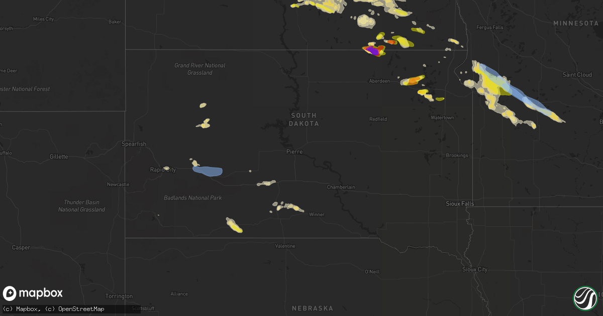
Hail Map in South Dakota on August 23, 2020
Get this storm
August 23 map
$229
one time, instant access
Download today. No call, no setup
Keep the $229
Bought the map and want the full workflow? Apply the entire $229 to a subscription within 7 days. None of it is wasted.
Every map, not just this one
This buys you this map. Subscription and you get every map we run, in the markets you choose from a few cities to whole states to nationwide. Plus real-time alerts the moment a storm fires.
Contact data
Name, contact info, occupancy, even credit band for addresses in the footprint. You go from where it hit to who to call.
Become the source they trust
Unlimited branding weather history reports on demand. You already have the documented answer ready for the property owner, and you are the one who showed up with it.
Property data and RoofTrace estimates
Pull up any address you have got, its value and the exact code rules for that jurisdiction, straight from One Click Code. Then RoofTrace estimates the squares, pitch, and roof value, priced the way you price.
Storm reports in South Dakota
South Dakota
| Date | Description |
|---|---|
| 08/23/20205:58 PM CDT | Mostly marble-sized hail. Said there were some up to one inch in diameter. 0.55in of rainfall... Too. |
| 08/23/20205:30 PM CDT | A local report indicates 4.00 inch wind near 9 E SPRING CREEK COLONY |
| 08/23/20205:30 PM CDT | A local report indicates 73 MPH wind near 3 NW WASTA |
| 08/23/20204:40 PM CDT | A local report indicates 58 MPH wind near RAPID CITY ARPT |
| 08/23/20203:08 AM CDT | At 806 PM CDT/706 PM MDT/, a severe thunderstorm was located near Midland, or 21 miles west of Murdo, moving east at 35 mph. HAZARD...70 mph wind gusts. SOURCE...Mesonet site in Midland, South Dakota reported a wind gust of 71 mph at 750 pm CDT. IMPACT...Expect considerable tree damage. Damage is likely to mobile homes, roofs, and outbuildings. Locations impacted include... Murdo, Draper, Okaton, Westover, Capa, Van Metre, Bunker and Wendte. |
| 08/23/20202:49 AM CDT | At 749 PM CDT, a severe thunderstorm was located over Sonora, or 17 miles southwest of Wahpeton, moving east at 15 mph. HAZARD...Quarter size hail. SOURCE...Radar indicated. IMPACT...Damage to vehicles is expected. This severe thunderstorm will be near... Sonora around 750 PM CDT. Lamars around 810 PM CDT. Fairmount around 815 PM CDT. Blackmer around 820 PM CDT. Tenney around 830 PM CDT.This includes Interstate 29 between mile markers 2 and 14. |
| 08/23/20202:09 AM CDT | A few hailstones up to golf ball sized. Radar estimated time. |
| 08/23/20202:07 AM CDT | Photo via social media. Radar estimated time. |
| 08/23/202012:52 AM CDT | At 552 PM CDT, a severe thunderstorm was located near Claire City, or 10 miles north of Sisseton, moving east at 25 mph. HAZARD...Golf ball size hail and 60 mph wind gusts. SOURCE...Radar indicated. IMPACT...People and animals outdoors will be injured. Expect hail damage to roofs, siding, windows, and vehicles. Expect wind damage to roofs, siding, and trees. Locations impacted include... New Effington, Claire City, Lake Traverse Housing Units and Lake Traverse. |
| 08/22/20208:53 PM CDT | 18 inch cedar tree downed via photo on social media. Event time is based on a personal weather station which recorded a peak gust of 55 mph. |
| 08/22/20208:25 PM CDT | Gust recorded on personal weather station. Damage to silo as well. |
| 08/22/20207:50 PM CDT | A local report indicates 71 MPH wind near 1 NE MIDLAND |
| 08/22/20207:45 PM CDT | A local report indicates 60 MPH wind near 1 NE MIDLAND |
| 08/22/20207:27 PM CDT | A local report indicates 65 MPH wind near 7 E WANBLEE |
All States Impacted by Hail Map on August 23, 2020
Cities Impacted by Hail Map on August 23, 2020
- Owanka, SD
- Wasta, SD
- Tappen, ND
- Ypsilanti, ND
- Valley City, ND
- Baldwin, ND
- Streeter, ND
- Napoleon, ND
- Fort Ransom, ND
- Lisbon, ND
- Verona, ND
- Medina, ND
- Jud, ND
- Marion, ND
- Montpelier, ND
- Jamestown, ND
- Steele, ND
- Litchville, ND
- Pettibone, ND
- Driscoll, ND
- Pingree, ND
- Dawson, ND
- Tuttle, ND
- Gackle, ND
- Sterling, ND
- Cleveland, ND
- Spiritwood, ND
- Robinson, ND
- Sanborn, ND
- Kintyre, ND
- Wing, ND
- Regan, ND
- Woodworth, ND
- Faith, SD
- Mud Butte, SD
- Union Center, SD
- Palatine, IL
- Rolling Meadows, IL
- Arlington Heights, IL
- Sutton, MA
- Dumont, MN
- Chokio, MN
- Menomonee Falls, WI
- Milwaukee, WI
- Butler, WI
- Selkirk, NY
- Fairmount, ND
- Hankinson, ND
- Tuthill, SD
- Martin, SD
- Allen, SD
- Hackberry, AZ
- Oakes, ND
- Ellendale, ND
- Brockton, MA
- Dedham, MA
- South Easton, MA
- Foxboro, MA
- North Easton, MA
- Norwood, MA
- Sharon, MA
- East Walpole, MA
- Stoughton, MA
- Westwood, MA
- Canton, MA
- Worcester, MA
- Millbury, MA
- Auburn, MA
- Pekin, IL
- Tremont, IL
- Buchanan, ND
- Raymond, MN
- Willmar, MN
- Pennock, MN
- Kerkhoven, MN
- Londonderry, NH
- Hudson, NH
- Windham, NH
- Clinton, MN
- Corona, SD
- Ortonville, MN
- Edgeley, ND
- Spencer, MA
- Paxton, MA
- Leicester, MA
- Holden, MA
- Cherry Valley, MA
- Winchester, NH
- Swanzey, NH
- Forbes, ND
- Caputa, SD
- Rapid City, SD
- White River, SD
- Danvers, MN
- Hancock, MN
- Granite Falls, MN
- Maynard, MN
- Montevideo, MN
- Cuervo, NM
- New Underwood, SD
- Waubay, SD
- Webster, SD
- Frederick, SD
- Leola, SD
- Beardsley, MN
- Spencer, NY
- Newfield, NY
- Ithaca, NY
- Prescott, AZ
- Sacred Heart, MN
- Erving, MA
- Orange, MA
- Wendell, MA
- Wendell Depot, MA
- Box Elder, SD
- Correll, MN
- Appleton, MN
- Las Cruces, NM
- Hazelton, ND
- Moffit, ND
- Seligman, AZ
- Wood, SD
- Summit, SD
- Kulm, ND
- Cogswell, ND
- Alberta, MN
- Morris, MN
- Wheaton, MN
- Donnelly, MN
- Odessa, MN
- Dawson, MN
- Milan, MN
- Benson, MN
- Madison, MN
- Graceville, MN
- Clontarf, MN
- Holloway, MN
- Las Vegas, NV
- House, NM
- West Pawlet, VT
- Claire City, SD
- Pierpont, SD
- Elmer, NJ
- Danube, MN
- Renville, MN
- Cosmos, MN
- Lake Lillian, MN
- Blomkest, MN
- Hector, MN
- Hutchinson, MN
- Atwater, MN
- Stewart, MN
- Buffalo Lake, MN
- Fullerton, ND
- Roslyn, SD
- Andover, SD
- Braddock, ND
- Ware, MA
- Hardwick, MA
- Coeymans Hollow, NY
- Glenmont, NY
- Feura Bush, NY
- Alcove, NY
- Hannacroix, NY
- South Bethlehem, NY
- Ravena, NY
- Delmar, NY
- Wilmington, MA
- Wakefield, MA
- Saugus, MA
- Melrose, MA
- Woburn, MA
- Winchester, MA
- Medford, MA
- Malden, MA
- Stoneham, MA
- Reading, MA
- Burlington, MA
- Olivia, MN
- Happy Jack, AZ
- New Braintree, MA
- West Brookfield, MA
- North Brookfield, MA
- Milton, MA
- Mansfield, MA
- Walpole, MA
- Hyde Park, MA
- Putnam Station, NY
- Fair Haven, VT
- Melrose, NM
- Voorheesville, NY
- Westerlo, NY
- Clarksville, NY
- East Berne, NY
- Middle River, MD
- Essex, MD
- Warren, MA
- Gilbertville, MA
- Fremont, NH
- Epping, NH
- Exeter, NH
- Northborough, MA
- Shrewsbury, MA
- Westborough, MA
- Wimbledon, ND
- Brownsville, VT
- Windsor, VT
- Gwinner, ND
- Winner, SD
- Elm Grove, WI
- Brookfield, WI
- Fort Sumner, NM
- Gurnee, IL
- Middletown Springs, VT
- Lincolnshire, IL
- Lake Bluff, IL
- Highwood, IL
- Northbrook, IL
- Highland Park, IL
- Deerfield, IL
- Great Lakes, IL
- Wheeling, IL
- Lake Forest, IL
- Buffalo Grove, IL
- Willseyville, NY
- Candor, NY
- Morocco, IN
- Lake Village, IN
- Fair Oaks, IN
- Oral, SD
- New Berlin, WI
- Newfields, NH
- Bridgeton, NJ
- Sherborn, MA
- Holliston, MA
- Ashland, MA
- Milnor, ND
- Chester, VT
- Saint Anne, IL
- Pembroke Township, IL
- Lamoure, ND
- Randolph, MA
- Belchertown, MA
- Lockwood, NY
- Hoffman Estates, IL
- Schaumburg, IL
- New Ipswich, NH
- Fort Ann, NY
- Whitehall, NY
- Sisseton, SD
- Schoharie, NY
- Overton, NV
- Mercer, ND
- Momence, IL
- Delanson, NY
- Southborough, MA
- Bristol, SD
- Groton, SD
- New Salem, MA
- Athol, MA
- Warwick, MA
- Hopkinton, MA
- Candia, NH
- Deerfield, NH
- Kirkland, AZ
- Hamilton, NY
- Britton, SD
- Canajoharie, NY
- Coleharbor, ND
- Duanesburg, NY
- Okaton, SD
- Millville, NJ
- Cedarville, NJ
- Dickey, ND
- Big Stone City, SD
- Watson, MN
- Wells, VT
- Granville, NY
- North Andover, MA
- Andover, MA
- Hudson, MA
- East Boston, MA
- Boston, MA
- Wayland, MA
- Waltham, MA
- Weston, MA
- Brighton, MA
- Cambridge, MA
- Lincoln, MA
- Watertown, MA
- Lexington, MA
- Arlington, MA
- Charlestown, MA
- Chelsea, MA
- Allston, MA
- Belmont, MA
- Willow Beach, AZ
- Palmer, MA
- Berlin, MA
- Marlborough, MA
- Stow, MA
- Albert Lea, MN
- Barre, MA
- Bondsville, MA
- Grafton, MA
- Brookfield, MA
- Rutland, MA
- Charlton, MA
- Jefferson, MA
- Rochdale, MA
- Oakham, MA
- North Oxford, MA
- East Brookfield, MA
- South Barre, MA
- South Grafton, MA
- Oxford, MA
- Thorndike, MA
- Kathryn, ND
- Libertyville, IL
- Grayslake, IL
- Cavendish, VT
- Perkinsville, VT
- Keene, NH
- Howes Cave, NY
- Berne, NY
- Lake Zurich, IL
- Vernon Hills, IL
- Crown King, AZ
- Elk Grove Village, IL
- Raymond, NH
- Nottingham, NH
- Atkinson, NH
- Haverhill, MA
- Canton, IL
- Cuba, IL
- Troy, NH
- Spofford, NH
- Earlville, NY
- Eaton, NY
- Trumansburg, NY
- Revere, MA
- North Reading, MA
- Lynnfield, MA
- Lawrence, MA
- Tewksbury, MA
- Boxford, MA
- Lynn, MA
- Oxford, NY
- Mount Prospect, IL
- Prospect Heights, IL
- Slingerlands, NY
- Altamont, NY
- Murdo, SD
- Belvidere, SD
- Midland, SD
- Kingman, AZ
- Springfield, VT
- Saint George, UT
- Smyrna, NY
- Dundalk, MD
- Baltimore, MD
- Rosedale, MD
- Globe, AZ
- Orwell, VT
- Hague, NY
- Silver Bay, NY
- Framingham, MA
- Bismarck, ND
- Stirum, ND
- Ortley, SD
- Kandiyohi, MN
- Murdock, MN
- Philip, SD
- Quinn, SD
- Wall, SD
- Albany, NY
- Rindge, NH


