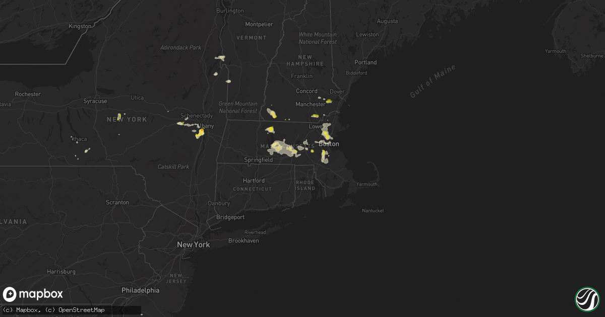
Hail Map in Massachusetts on August 23, 2020
Get this storm
August 23 map
$229
one time, instant access
Download today. No call, no setup
Keep the $229
Bought the map and want the full workflow? Apply the entire $229 to a subscription within 7 days. None of it is wasted.
Every map, not just this one
This buys you this map. Subscription and you get every map we run, in the markets you choose from a few cities to whole states to nationwide. Plus real-time alerts the moment a storm fires.
Contact data
Name, contact info, occupancy, even credit band for addresses in the footprint. You go from where it hit to who to call.
Become the source they trust
Unlimited branding weather history reports on demand. You already have the documented answer ready for the property owner, and you are the one who showed up with it.
Property data and RoofTrace estimates
Pull up any address you have got, its value and the exact code rules for that jurisdiction, straight from One Click Code. Then RoofTrace estimates the squares, pitch, and roof value, priced the way you price.
Storm reports in Massachusetts
Massachusetts
| Date | Description |
|---|---|
| 08/23/20206:39 PM CDT | Tree down blocking road on state st. |
| 08/23/20206:30 PM CDT | Trees and wires down on belchertown rd. |
| 08/23/20206:10 PM CDT | Large tree down on power lines on warner st. Multiple trees and wires down on east st from swift river wildlife to cold spring rd. |
| 08/23/20206:10 PM CDT | Multiple trees and wires down on ragged hill road. |
| 08/23/20206:05 PM CDT | Tree fell on roof of house on east main st with no injuries. Tree down on wires on myrick rd. |
| 08/23/20206:04 PM CDT | Power lines down blocking road on aldrich drive. |
| 08/23/20205:55 PM CDT | Trees and wires down on miller drive. Tree down on rte 67 near west brookfield line blocking road. |
| 08/23/20205:30 PM CDT | Tree down across the road on highland street. Tree down on wires on depot st. |
| 08/23/20205:10 PM CDT | High voltage power line down on pearl st. Tree and wires down on holy lane. Tree down blocking road on south st/fisher st. |
| 08/23/20205:00 PM CDT | Trees and wires down on lawrence st and fuller st. |
| 08/23/20205:00 PM CDT | Tree down on cristo lane blocking road. |
| 08/23/20205:00 PM CDT | Multiple trees and wires down on strasser ave and fearing drive. |
| 08/23/20205:00 PM CDT | Tree down on wires on henshaw st at south main st. Tree down on powerlines on white birch st. Tree down on marshall st. Tree down on greenville circle. |
| 08/23/20204:46 PM CDT | A local report indicates 60 MPH wind near BLUE HILL COOP |
| 08/23/20204:46 PM CDT | A local report indicates 59 MPH wind near NORWOOD AP |
| 08/23/20204:41 PM CDT | A local report indicates 1.00 inch wind near WORCESTER |
| 08/23/20204:40 PM CDT | Wires down on mower st... Brightwood ave and main st |
| 08/23/20204:35 PM CDT | Trees down on wires on carolyn drive... Linda st and haskell st |
| 08/23/20204:30 PM CDT | Tree down on brightwood ave |
| 08/23/20204:25 PM CDT | Tree down...went through a trailer in martys trailer park on southwest cutoff. No injuries. |
| 08/23/20204:20 PM CDT | Tree down on fisher st at otis st |
| 08/23/20204:18 PM CDT | A local report indicates 62 MPH wind near WORCESTER AP |
| 08/23/20204:15 PM CDT | Tree and wires down in the road on barre-paxton rd. |
| 08/23/20204:06 PM CDT | Tree down on rte 99 just before us rte 1 |
| 08/23/20204:05 PM CDT | Tree down on wires on hobson st |
| 08/23/20204:05 PM CDT | Tree and wires down across road and a driveway on spencer rd. |
| 08/23/20203:56 PM CDT | Large tree down on loring road in the area of south st. Tree down on root road at south st. Tree and wires down on clem court. Tree and wires down on church st. Tree an |
| 08/23/20203:45 PM CDT | Trees down on avon ave... Green st. Tree down on house on main st at lake |
| 08/23/20203:45 PM CDT | A local report indicates 1.00 inch wind near WAKEFIELD |
| 08/23/20203:45 PM CDT | Tree down on car on franklin st |
| 08/23/20203:24 PM CDT | Tree down on car and blocking road on woodstock rd. |
| 08/23/20203:20 PM CDT | Tree down on wires on wilmor rd |
| 08/23/20203:12 PM CDT | Tree down on house and blocking road on oak rd |
| 08/23/20203:10 PM CDT | Tree down on college rd |
| 08/23/20202:52 PM CDT | Trees and wires down on jonathan dr and groton school rd |
| 08/23/20202:46 PM CDT | Tree down blocking road on 7th st |
| 08/23/20202:46 PM CDT | Large trees down on townsend rd |
| 08/23/20202:45 PM CDT | Trees and poles down on ashby state rd |
| 08/23/20202:45 PM CDT | Tree down on cars on cove rd |
| 08/23/20202:43 PM CDT | Tree down on house at brigham park |
| 08/23/20202:40 PM CDT | Large tree down blocking road on orchard hill rd... Tree down on wires on brookside rd |
| 08/23/20202:36 PM CDT | Tree down blocking road on rogers ave |
| 08/23/20202:35 PM CDT | Tree and wires down on hillcrest rd and daniel shays hwy. |
| 08/23/20202:31 PM CDT | Tree down on house on roosevelt ave |
| 08/23/20202:26 PM CDT | Trees and wires down on east river st... East main st and brookside rd |
| 08/23/20201:56 PM CDT | Trees down on north orange rd... West orange rd... Wheeler ave and north main st. Damage began at 256pm and continued through 315pm. |
| 08/23/20202:22 AM CDT | At 721 PM EDT, a severe thunderstorm was located over Palmer, or 14 miles northeast of Springfield, moving east at 15 mph. HAZARD...60 mph wind gusts and quarter size hail. SOURCE...Radar indicated. IMPACT...Expect wind damage to trees and power lines. Minor hail damage to vehicles is possible. Locations impacted include... Worcester, Shrewsbury, Ludlow, Westborough, Grafton, Webster, Southbridge, Auburn, Northbridge, Belchertown, Wilbraham, Northborough, Oxford, Uxbridge, Millbury, Charlton, Palmer, Spencer, Dudley and Leicester. |
| 08/23/20201:32 AM CDT | At 632 PM EDT, a severe thunderstorm was located over Granby, or near Chicopee, moving east at 15 mph. HAZARD...60 mph wind gusts and quarter size hail. SOURCE...Radar indicated. IMPACT...Expect wind damage to trees and power lines. Minor hail damage to vehicles is possible. Locations impacted include... Worcester, Chicopee, Amherst, Ludlow, South Hadley, Holden, Auburn, Belchertown, Wilbraham, Oxford, Millbury, Charlton, Palmer, Spencer, Leicester, Ware, Rutland, West Boylston, Granby and Hadley. |
| 08/23/20201:15 AM CDT | At 615 PM EDT, a severe thunderstorm was located over Petersham, or 12 miles south of Orange, moving east at 15 mph. HAZARD...Ping pong ball size hail and 60 mph wind gusts. SOURCE...Radar indicated. IMPACT...Expect wind damage to trees and power lines. Minor hail damage to vehicles is possible. Locations impacted include... Worcester, Leominster, Holden, Belchertown, Spencer, Athol, Ware, Templeton, Rutland, Sterling, West Boylston, Westminster, Barre, Paxton, North Brookfield, Hubbardston, Princeton, Hardwick, Oakham and Phillipston. |
| 08/23/20201:10 AM CDT | At 609 PM EDT, a severe thunderstorm was located over Stoughton, moving east at 15 mph. HAZARD...60 mph wind gusts. SOURCE...Radar indicated. This storm has a history of producing significant wind damage. Seek an indoor shelter immediately! IMPACT...Expect damage to trees and power lines. Locations impacted include... Brockton, Weymouth, Braintree, Randolph, Norwood, Stoughton, Marshfield, Walpole, Mansfield, Easton, Hingham, Canton, Scituate, Pembroke, Sharon, Rockland, Foxborough, Abington, Duxbury and Westwood. |
| 08/23/202012:38 AM CDT | At 537 PM EDT, a severe thunderstorm was located over Millbury, or near Worcester, moving east at 15 mph. HAZARD...60 mph wind gusts and quarter size hail. SOURCE...Radar indicated. In addition, these storms have a history of significant wind damage. This includes downed trees and scattered power outages. Seek an indoor shelter immediately. IMPACT...Expect wind damage to trees and power lines. Minor hail damage to vehicles is possible. Locations impacted include... Boston, Worcester, Brockton, Quincy, Newton, Framingham, Brookline, Weymouth, Braintree, Shrewsbury, Natick, Randolph, Franklin, Needham, Norwood, Milford, Wellesley, Milton, Stoughton and Marshfield. |
| 08/23/202012:28 AM CDT | At 528 PM EDT, a severe thunderstorm was located over West Brookfield, or 16 miles west of Worcester, moving east at 15 mph. HAZARD...60 mph wind gusts and quarter size hail. SOURCE...Radar indicated. IMPACT...Expect wind damage to trees and power lines. Minor hail damage to vehicles is possible. Locations impacted include... Worcester, Springfield, Ludlow, Southbridge, Auburn, Belchertown, Wilbraham, Oxford, Charlton, Palmer, Spencer, Leicester, Ware, Sturbridge, Monson, Granby, Warren, Paxton, North Brookfield and West Brookfield. |
| 08/23/202012:12 AM CDT | At 510 PM EDT, a severe thunderstorm was located over Wellesley, moving east at 15 mph. HAZARD...60 mph wind gusts and quarter size hail. SOURCE...Radar indicated. These thunderstorms have a history of wind and tree damage across many parts of central and northeast Massachusetts. Seek an indoor shelter immediately. IMPACT...Expect wind damage to trees and power lines. Minor hail damage to vehicles is possible. Locations impacted include... Boston, Cambridge, Quincy, Lynn, Newton, Somerville, Framingham, Waltham, Malden, Brookline, Medford, Weymouth, Revere, Arlington, Everett, Braintree, Chelsea, Natick, Randolph and Watertown. |
| 08/22/202011:55 PM CDT | At 455 PM EDT, a severe thunderstorm was located over Paxton, or near Worcester, moving east at 15 mph. HAZARD...60 mph wind gusts and quarter size hail. SOURCE...Radar indicated. IMPACT...Expect wind damage to trees and power lines. Minor hail damage to vehicles is possible. Locations impacted include... Worcester, Framingham, Marlborough, Shrewsbury, Acton, Hudson, Westborough, Grafton, Holden, Southbridge, Ashland, Auburn, Northbridge, Hopkinton, Northborough, Oxford, Clinton, Millbury, Charlton and Spencer. |
| 08/22/202011:44 PM CDT | At 444 PM EDT, a severe thunderstorm was located near Rutland, or 13 miles southwest of Leominster, moving east at 15 mph. HAZARD...60 mph wind gusts and quarter size hail. SOURCE...Radar indicated. IMPACT...Expect wind damage to trees and power lines. Minor hail damage to vehicles is possible. Locations impacted include... Worcester, Leominster, Fitchburg, Marlborough, Shrewsbury, Gardner, Holden, Northborough, Clinton, Spencer, Lunenburg, Lancaster, Templeton, Rutland, Sterling, West Boylston, Westminster, Shirley, Harvard and Barre. |
| 08/22/202011:34 PM CDT | At 433 PM EDT, a severe thunderstorm was located over Reading, or near Woburn, moving east at 15 mph. HAZARD...60 mph wind gusts and quarter size hail. SOURCE...Radar indicated. IMPACT...Expect wind damage to trees and power lines. Minor hail damage to vehicles is possible. Locations impacted include... Boston, Cambridge, Lynn, Newton, Somerville, Framingham, Waltham, Malden, Brookline, Medford, Revere, Peabody, Arlington, Everett, Salem, Billerica, Beverly, Marlborough, Woburn and Chelsea. |
| 08/22/202011:12 PM CDT | At 412 PM EDT, a severe thunderstorm was located over Stow, or near Marlborough, moving east at 15 mph. HAZARD...60 mph wind gusts and quarter size hail. SOURCE...Radar indicated. IMPACT...Expect wind damage to trees and power lines. Minor hail damage to vehicles is possible. Locations impacted include... Boston, Cambridge, Newton, Somerville, Framingham, Waltham, Malden, Brookline, Medford, Arlington, Marlborough, Woburn, Natick, Watertown, Lexington, Wellesley, Reading, Belmont, Burlington and Acton. |
| 08/22/20209:28 PM CDT | At 228 PM EDT, a severe thunderstorm was located over Salem, moving east at 15 mph. HAZARD...70 mph wind gusts and quarter size hail. SOURCE...Radar indicated. IMPACT...Hail damage to vehicles is expected. Expect considerable tree damage. Wind damage is also likely to mobile homes, roofs, and outbuildings. Locations impacted include... Derry, Salem, Hampstead, Atkinson, Windham, Plaistow and Newton. This includes Interstate 93 between mile markers 2 and 8. |
| 08/22/20209:21 PM CDT | At 220 PM EDT, severe thunderstorms were located along a line extending from near Marlborough to near Swanzey, moving east at 25 mph. HAZARD...60 mph wind gusts and penny size hail. SOURCE...Radar indicated. IMPACT...Expect damage to roofs, siding, and trees. Locations impacted include... Keene, Jaffrey, Swanzey, Peterborough, Winchester, Dublin, Richmond, Harrisville, Marlborough, Rindge, Roxbury, Fitzwilliam, Troy, Chesterfield and Sharon.This also includes... Mount Monadnock. |
| 08/22/20208:42 PM CDT | At 142 PM EDT, a severe thunderstorm was located over Hudson, or near Nashua, moving east at 15 mph. HAZARD...60 mph wind gusts and penny size hail. SOURCE...Radar indicated. IMPACT...Expect damage to roofs, siding, and trees. Locations impacted include... Nashua, Derry, Salem, Merrimack, Litchfield, Hudson, Pelham, Londonderry, Atkinson, Windham, Plaistow and Newton.This includes Interstate 93 between mile markers 1 and 11. |
| 08/22/20207:10 PM CDT | Tree down on wires on birch hill rd. |
All States Impacted by Hail Map on August 23, 2020
Cities Impacted by Hail Map on August 23, 2020
- Owanka, SD
- Wasta, SD
- Tappen, ND
- Ypsilanti, ND
- Valley City, ND
- Baldwin, ND
- Streeter, ND
- Napoleon, ND
- Fort Ransom, ND
- Lisbon, ND
- Verona, ND
- Medina, ND
- Jud, ND
- Marion, ND
- Montpelier, ND
- Jamestown, ND
- Steele, ND
- Litchville, ND
- Pettibone, ND
- Driscoll, ND
- Pingree, ND
- Dawson, ND
- Tuttle, ND
- Gackle, ND
- Sterling, ND
- Cleveland, ND
- Spiritwood, ND
- Robinson, ND
- Sanborn, ND
- Kintyre, ND
- Wing, ND
- Regan, ND
- Woodworth, ND
- Faith, SD
- Mud Butte, SD
- Union Center, SD
- Palatine, IL
- Rolling Meadows, IL
- Arlington Heights, IL
- Sutton, MA
- Dumont, MN
- Chokio, MN
- Menomonee Falls, WI
- Milwaukee, WI
- Butler, WI
- Selkirk, NY
- Fairmount, ND
- Hankinson, ND
- Tuthill, SD
- Martin, SD
- Allen, SD
- Hackberry, AZ
- Oakes, ND
- Ellendale, ND
- Brockton, MA
- Dedham, MA
- South Easton, MA
- Foxboro, MA
- North Easton, MA
- Norwood, MA
- Sharon, MA
- East Walpole, MA
- Stoughton, MA
- Westwood, MA
- Canton, MA
- Worcester, MA
- Millbury, MA
- Auburn, MA
- Pekin, IL
- Tremont, IL
- Buchanan, ND
- Raymond, MN
- Willmar, MN
- Pennock, MN
- Kerkhoven, MN
- Londonderry, NH
- Hudson, NH
- Windham, NH
- Clinton, MN
- Corona, SD
- Ortonville, MN
- Edgeley, ND
- Spencer, MA
- Paxton, MA
- Leicester, MA
- Holden, MA
- Cherry Valley, MA
- Winchester, NH
- Swanzey, NH
- Forbes, ND
- Caputa, SD
- Rapid City, SD
- White River, SD
- Danvers, MN
- Hancock, MN
- Granite Falls, MN
- Maynard, MN
- Montevideo, MN
- Cuervo, NM
- New Underwood, SD
- Waubay, SD
- Webster, SD
- Frederick, SD
- Leola, SD
- Beardsley, MN
- Spencer, NY
- Newfield, NY
- Ithaca, NY
- Prescott, AZ
- Sacred Heart, MN
- Erving, MA
- Orange, MA
- Wendell, MA
- Wendell Depot, MA
- Box Elder, SD
- Correll, MN
- Appleton, MN
- Las Cruces, NM
- Hazelton, ND
- Moffit, ND
- Seligman, AZ
- Wood, SD
- Summit, SD
- Kulm, ND
- Cogswell, ND
- Alberta, MN
- Morris, MN
- Wheaton, MN
- Donnelly, MN
- Odessa, MN
- Dawson, MN
- Milan, MN
- Benson, MN
- Madison, MN
- Graceville, MN
- Clontarf, MN
- Holloway, MN
- Las Vegas, NV
- House, NM
- West Pawlet, VT
- Claire City, SD
- Pierpont, SD
- Elmer, NJ
- Danube, MN
- Renville, MN
- Cosmos, MN
- Lake Lillian, MN
- Blomkest, MN
- Hector, MN
- Hutchinson, MN
- Atwater, MN
- Stewart, MN
- Buffalo Lake, MN
- Fullerton, ND
- Roslyn, SD
- Andover, SD
- Braddock, ND
- Ware, MA
- Hardwick, MA
- Coeymans Hollow, NY
- Glenmont, NY
- Feura Bush, NY
- Alcove, NY
- Hannacroix, NY
- South Bethlehem, NY
- Ravena, NY
- Delmar, NY
- Wilmington, MA
- Wakefield, MA
- Saugus, MA
- Melrose, MA
- Woburn, MA
- Winchester, MA
- Medford, MA
- Malden, MA
- Stoneham, MA
- Reading, MA
- Burlington, MA
- Olivia, MN
- Happy Jack, AZ
- New Braintree, MA
- West Brookfield, MA
- North Brookfield, MA
- Milton, MA
- Mansfield, MA
- Walpole, MA
- Hyde Park, MA
- Putnam Station, NY
- Fair Haven, VT
- Melrose, NM
- Voorheesville, NY
- Westerlo, NY
- Clarksville, NY
- East Berne, NY
- Middle River, MD
- Essex, MD
- Warren, MA
- Gilbertville, MA
- Fremont, NH
- Epping, NH
- Exeter, NH
- Northborough, MA
- Shrewsbury, MA
- Westborough, MA
- Wimbledon, ND
- Brownsville, VT
- Windsor, VT
- Gwinner, ND
- Winner, SD
- Elm Grove, WI
- Brookfield, WI
- Fort Sumner, NM
- Gurnee, IL
- Middletown Springs, VT
- Lincolnshire, IL
- Lake Bluff, IL
- Highwood, IL
- Northbrook, IL
- Highland Park, IL
- Deerfield, IL
- Great Lakes, IL
- Wheeling, IL
- Lake Forest, IL
- Buffalo Grove, IL
- Willseyville, NY
- Candor, NY
- Morocco, IN
- Lake Village, IN
- Fair Oaks, IN
- Oral, SD
- New Berlin, WI
- Newfields, NH
- Bridgeton, NJ
- Sherborn, MA
- Holliston, MA
- Ashland, MA
- Milnor, ND
- Chester, VT
- Saint Anne, IL
- Pembroke Township, IL
- Lamoure, ND
- Randolph, MA
- Belchertown, MA
- Lockwood, NY
- Hoffman Estates, IL
- Schaumburg, IL
- New Ipswich, NH
- Fort Ann, NY
- Whitehall, NY
- Sisseton, SD
- Schoharie, NY
- Overton, NV
- Mercer, ND
- Momence, IL
- Delanson, NY
- Southborough, MA
- Bristol, SD
- Groton, SD
- New Salem, MA
- Athol, MA
- Warwick, MA
- Hopkinton, MA
- Candia, NH
- Deerfield, NH
- Kirkland, AZ
- Hamilton, NY
- Britton, SD
- Canajoharie, NY
- Coleharbor, ND
- Duanesburg, NY
- Okaton, SD
- Millville, NJ
- Cedarville, NJ
- Dickey, ND
- Big Stone City, SD
- Watson, MN
- Wells, VT
- Granville, NY
- North Andover, MA
- Andover, MA
- Hudson, MA
- East Boston, MA
- Boston, MA
- Wayland, MA
- Waltham, MA
- Weston, MA
- Brighton, MA
- Cambridge, MA
- Lincoln, MA
- Watertown, MA
- Lexington, MA
- Arlington, MA
- Charlestown, MA
- Chelsea, MA
- Allston, MA
- Belmont, MA
- Willow Beach, AZ
- Palmer, MA
- Berlin, MA
- Marlborough, MA
- Stow, MA
- Albert Lea, MN
- Barre, MA
- Bondsville, MA
- Grafton, MA
- Brookfield, MA
- Rutland, MA
- Charlton, MA
- Jefferson, MA
- Rochdale, MA
- Oakham, MA
- North Oxford, MA
- East Brookfield, MA
- South Barre, MA
- South Grafton, MA
- Oxford, MA
- Thorndike, MA
- Kathryn, ND
- Libertyville, IL
- Grayslake, IL
- Cavendish, VT
- Perkinsville, VT
- Keene, NH
- Howes Cave, NY
- Berne, NY
- Lake Zurich, IL
- Vernon Hills, IL
- Crown King, AZ
- Elk Grove Village, IL
- Raymond, NH
- Nottingham, NH
- Atkinson, NH
- Haverhill, MA
- Canton, IL
- Cuba, IL
- Troy, NH
- Spofford, NH
- Earlville, NY
- Eaton, NY
- Trumansburg, NY
- Revere, MA
- North Reading, MA
- Lynnfield, MA
- Lawrence, MA
- Tewksbury, MA
- Boxford, MA
- Lynn, MA
- Oxford, NY
- Mount Prospect, IL
- Prospect Heights, IL
- Slingerlands, NY
- Altamont, NY
- Murdo, SD
- Belvidere, SD
- Midland, SD
- Kingman, AZ
- Springfield, VT
- Saint George, UT
- Smyrna, NY
- Dundalk, MD
- Baltimore, MD
- Rosedale, MD
- Globe, AZ
- Orwell, VT
- Hague, NY
- Silver Bay, NY
- Framingham, MA
- Bismarck, ND
- Stirum, ND
- Ortley, SD
- Kandiyohi, MN
- Murdock, MN
- Philip, SD
- Quinn, SD
- Wall, SD
- Albany, NY
- Rindge, NH


