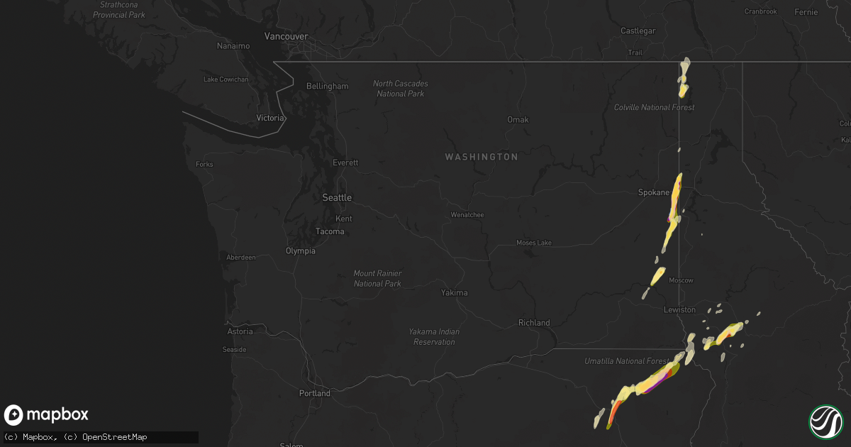
Hail Map in Washington on August 11, 2022
Get this storm
August 11 map
$229
one time, instant access
Download today. No call, no setup
Keep the $229
Bought the map and want the full workflow? Apply the entire $229 to a subscription within 7 days. None of it is wasted.
Every map, not just this one
This buys you this map. Subscription and you get every map we run, in the markets you choose from a few cities to whole states to nationwide. Plus real-time alerts the moment a storm fires.
Contact data
Name, contact info, occupancy, even credit band for addresses in the footprint. You go from where it hit to who to call.
Become the source they trust
Unlimited branding weather history reports on demand. You already have the documented answer ready for the property owner, and you are the one who showed up with it.
Property data and RoofTrace estimates
Pull up any address you have got, its value and the exact code rules for that jurisdiction, straight from One Click Code. Then RoofTrace estimates the squares, pitch, and roof value, priced the way you price.
Storm reports in Washington
Washington
| Date | Description |
|---|---|
| 08/11/20226:54 PM CDT | Downed power lines and power outages in the latah area. Time estimated from radar. |
| 08/11/20226:45 PM CDT | Winds breaking tree branches. Hail the size of dimes. |
| 08/11/20226:38 PM CDT | Downed power lines and power outages just west of oakesdale. Time estimated from radar. |
| 08/11/20226:00 PM CDT | Heavy rain followed by 5 minutes of hail that covered most of the ground. Time estimated from radar. |
| 08/11/20226:00 PM CDT | Time estimated from radar. |
| 08/11/20223:29 AM CDT | At 829 PM PDT, a severe thunderstorm was located near Nordman, or 27 miles west of Bonners Ferry, moving northeast at 25 mph. HAZARD...60 mph wind gusts and quarter size hail. SOURCE...Radar indicated. IMPACT...Hail damage to vehicles is expected. Expect wind damage to roofs, siding, and trees. Locations impacted include... Nordman and Beaver Creek Campground. |
| 08/11/202212:40 AM CDT | At 539 PM PDT, a severe thunderstorm was located over Liberty Lake, or 7 miles southwest of Post Falls, moving north at 35 mph. HAZARD...Golf ball size hail and 70 mph wind gusts. SOURCE...Broadcast media reported on social media of numerous trees down and multiple power outages in the Rockford area. IMPACT...People and animals outdoors will be injured. Expect hail damage to roofs, siding, windows, and vehicles. Expect considerable tree damage. Wind damage is also likely to mobile homes, roofs, and outbuildings. Locations impacted include... Spokane Valley, Coeur d'Alene, Post Falls, Hayden, Rathdrum, Dalton Gardens, Liberty Lake, Hauser, Hayden Lake, Harrison, Green Acres, Otis Orchards-East Farms, Trentwood, Otis Orchards, Fernan Lake Village, Huetter, State Line, Newman Lake, Mount Spokane and Chilco.This includes the following highways... Interstate 90 in Washington between mile markers 291 and 299. Interstate 90 in Idaho between mile markers 0 and 18. U.S. Highway 95 in Idaho between mile markers 412 and 447. |
| 08/11/202212:07 AM CDT | At 507 PM PDT, a severe thunderstorm was located 11 miles northwest of Plummer, or 18 miles south of Spokane Valley, moving northeast at 40 mph. HAZARD...Golf ball size hail and 60 mph wind gusts. SOURCE...Radar indicated. IMPACT...People and animals outdoors will be injured. Expect hail damage to roofs, siding, windows, and vehicles. Expect wind damage to roofs, siding, and trees. Locations impacted include... Spokane Valley, Coeur d'Alene, Post Falls, Dalton Gardens, Liberty Lake, Hauser, Green Acres, Otis Orchards-East Farms, Trentwood, Otis Orchards, Fairfield, Rockford, Worley, Latah, Fernan Lake Village, Waverly, Huetter, State Line, Newman Lake and Valleyford.This includes the following highways... Interstate 90 in Washington between mile markers 290 and 299. Interstate 90 in Idaho between mile markers 0 and 17. U.S. Highway 95 in Idaho between mile markers 402 and 433. |
| 08/10/202211:34 PM CDT | At 433 PM PDT, a severe thunderstorm was located 17 miles north of Colfax, or 27 miles north of Pullman, moving northeast at 45 mph. HAZARD...Quarter size hail. SOURCE...Radar indicated. IMPACT...Damage to vehicles is expected. Locations impacted include... Harrison, Tekoa, Fairfield, Rockford, Oakesdale, Worley, Latah and Belmont.This includes U.S. Highway 95 in Idaho between mile markers 397 and413. |
| 08/10/202210:00 PM CDT | At 300 PM PDT, a severe thunderstorm was located 10 miles southwest of Winchester, or 17 miles south of Lapwai, moving northeast at 20 mph. HAZARD...60 mph wind gusts and half dollar size hail. SOURCE...Radar indicated. IMPACT...Hail damage to vehicles is expected. Expect wind damage to roofs, siding, and trees. Locations impacted include... Culdesac, Winchester, Reubens and Waha. This includes U.S. Highway 95 in Idaho between mile markers 278 and296. |
| 08/10/20227:59 PM CDT | Report and photo via social media. Time estimated from radar. |
| 08/10/20227:57 PM CDT | Report from mping: ping pong ball |
| 08/10/20227:54 PM CDT | Peak wind of 29 mph. |
| 08/10/20227:49 PM CDT | Report from mping: quarter |
| 08/10/20227:48 PM CDT | Mping report. Time estimated from radar. |
| 08/10/20227:48 PM CDT | Damaging hail and wind gusts 60 mph. |
| 08/10/20227:46 PM CDT | Report from mping: ping pong ball |
| 08/10/20227:45 PM CDT | Mping report. Time estimated from radar. |
| 08/10/20227:45 PM CDT | Picture from twitter. |
| 08/10/20227:45 PM CDT | Mping report. Time estimated from radar. |
| 08/10/20227:16 PM CDT | Downed power lines and widespread power outages to the east and southeast of rockford. Time estimated from radar. |
| 08/10/20227:15 PM CDT | Picture of many trees down in rockford over the road. |
| 08/10/20227:15 PM CDT | Report from mping: 1-inch tree limbs broken; shingles blown off. |
| 08/10/20227:15 PM CDT | Tree damage to fairview cemetery. |
| 08/10/20227:10 PM CDT | A local report indicates 1.00 inch wind near 3 E FAIRFIELD |
| 08/10/20227:05 PM CDT | Downed power lines and power outages east of fairfield. Time estimated from radar. |
| 08/10/20227:00 PM CDT | Multiple reports of wind damage on the southwest side of rockford. Time estimated from radar. |
All States Impacted by Hail Map on August 11, 2022
Cities Impacted by Hail Map on August 11, 2022
- Daniel, WY
- Ten Sleep, WY
- Colfax, WA
- Pullman, WA
- Edinburg, TX
- Mission, TX
- Worley, ID
- Otis Orchards, WA
- Rathdrum, ID
- Latah, WA
- Newman Lake, WA
- Fairfield, WA
- Oakesdale, WA
- Greenacres, WA
- Liberty Lake, WA
- Tekoa, WA
- Post Falls, ID
- Coeur D Alene, ID
- Mica, WA
- Plummer, ID
- Rockford, WA
- Kamiah, ID
- Greencreek, ID
- Nezperce, ID
- Cottonwood, ID
- Ferdinand, ID
- La Grande, OR
- Parma, ID
- Alexander, IA
- Belmond, IA
- Rocksprings, TX
- Nordman, ID
- Tombstone, AZ
- Hereford, AZ
- Culdesac, ID
- Lenore, ID
- Murphy, ID
- George West, TX
- Elgin, OR
- Colo, IA
- Hubbard, IA
- Radcliffe, IA
- Zearing, IA
- Alden, IA
- McCallsburg, IA
- Lewiston, ID
- Wallowa, OR
- Enterprise, OR
- Summerville, OR
- Cove, OR
- Imbler, OR
- Cary, NC
- Raleigh, NC
- Kenedy, TX
- Craigmont, ID
- Weippe, ID
- Homedale, ID
- Marsing, ID
- Grangeville, ID
- Pierce, ID
- Lake Mary, FL
- Goliad, TX
- Oldtown, ID
- Blanchard, ID
- White Bird, ID
- Savannah, GA
- Caldwell, ID
- Peck, ID
- Winchester, ID
- Imnaha, OR
- Evanston, WY
- Frenchville, ME
- Madawaska, ME
- Swaledale, IA
- Alzada, MT
- Moab, UT
- Coalville, UT
- Britt, IA
- Fruitland, ID
- New Plymouth, ID
- Wilder, ID
- Fort Myers, FL
- Latimer, IA
- Saint Maries, ID
- Pomeroy, WA
- Eureka, UT
- Stockton, UT
- Park City, UT
- New Providence, IA
- Clemons, IA
- Union, IA
- Millwood, GA
- Axson, GA
- Nicholls, GA
- Bonners Ferry, ID


