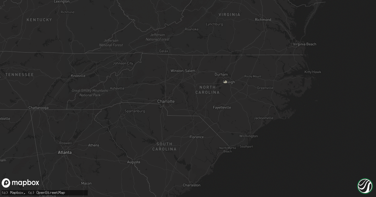
Hail Map in North Carolina on August 11, 2022
Get this storm
August 11 map
$229
one time, instant access
Download today. No call, no setup
Keep the $229
Bought the map and want the full workflow? Apply the entire $229 to a subscription within 7 days. None of it is wasted.
Every map, not just this one
This buys you this map. Subscription and you get every map we run, in the markets you choose from a few cities to whole states to nationwide. Plus real-time alerts the moment a storm fires.
Contact data
Name, contact info, occupancy, even credit band for addresses in the footprint. You go from where it hit to who to call.
Become the source they trust
Unlimited branding weather history reports on demand. You already have the documented answer ready for the property owner, and you are the one who showed up with it.
Property data and RoofTrace estimates
Pull up any address you have got, its value and the exact code rules for that jurisdiction, straight from One Click Code. Then RoofTrace estimates the squares, pitch, and roof value, priced the way you price.
Storm reports in North Carolina
North Carolina
| Date | Description |
|---|---|
| 08/11/20226:10 PM CDT | Trees were reported down on power lines along southall road near buffaloe road. |
| 08/11/20225:58 PM CDT | Trees were reported down on power lines near the intersection of strother road and garrett road. |
| 08/11/20221:56 AM CDT | At 656 PM EDT, a severe thunderstorm was located over Cary, moving east at 25 mph. HAZARD...60 mph wind gusts and quarter size hail. SOURCE...Radar indicated. IMPACT...Hail damage to vehicles is expected. Expect wind damage to roofs, siding, and trees. Locations impacted include... Raleigh, Cary, Garner, Clayton, Zebulon, Apex, Holly Springs, Morrisville, Knightdale and Wendell. |
All States Impacted by Hail Map on August 11, 2022
Cities Impacted by Hail Map on August 11, 2022
- Daniel, WY
- Ten Sleep, WY
- Colfax, WA
- Pullman, WA
- Edinburg, TX
- Mission, TX
- Worley, ID
- Otis Orchards, WA
- Rathdrum, ID
- Latah, WA
- Newman Lake, WA
- Fairfield, WA
- Oakesdale, WA
- Greenacres, WA
- Liberty Lake, WA
- Tekoa, WA
- Post Falls, ID
- Coeur D Alene, ID
- Mica, WA
- Plummer, ID
- Rockford, WA
- Kamiah, ID
- Greencreek, ID
- Nezperce, ID
- Cottonwood, ID
- Ferdinand, ID
- La Grande, OR
- Parma, ID
- Alexander, IA
- Belmond, IA
- Rocksprings, TX
- Nordman, ID
- Tombstone, AZ
- Hereford, AZ
- Culdesac, ID
- Lenore, ID
- Murphy, ID
- George West, TX
- Elgin, OR
- Colo, IA
- Hubbard, IA
- Radcliffe, IA
- Zearing, IA
- Alden, IA
- McCallsburg, IA
- Lewiston, ID
- Wallowa, OR
- Enterprise, OR
- Summerville, OR
- Cove, OR
- Imbler, OR
- Cary, NC
- Raleigh, NC
- Kenedy, TX
- Craigmont, ID
- Weippe, ID
- Homedale, ID
- Marsing, ID
- Grangeville, ID
- Pierce, ID
- Lake Mary, FL
- Goliad, TX
- Oldtown, ID
- Blanchard, ID
- White Bird, ID
- Savannah, GA
- Caldwell, ID
- Peck, ID
- Winchester, ID
- Imnaha, OR
- Evanston, WY
- Frenchville, ME
- Madawaska, ME
- Swaledale, IA
- Alzada, MT
- Moab, UT
- Coalville, UT
- Britt, IA
- Fruitland, ID
- New Plymouth, ID
- Wilder, ID
- Fort Myers, FL
- Latimer, IA
- Saint Maries, ID
- Pomeroy, WA
- Eureka, UT
- Stockton, UT
- Park City, UT
- New Providence, IA
- Clemons, IA
- Union, IA
- Millwood, GA
- Axson, GA
- Nicholls, GA
- Bonners Ferry, ID


