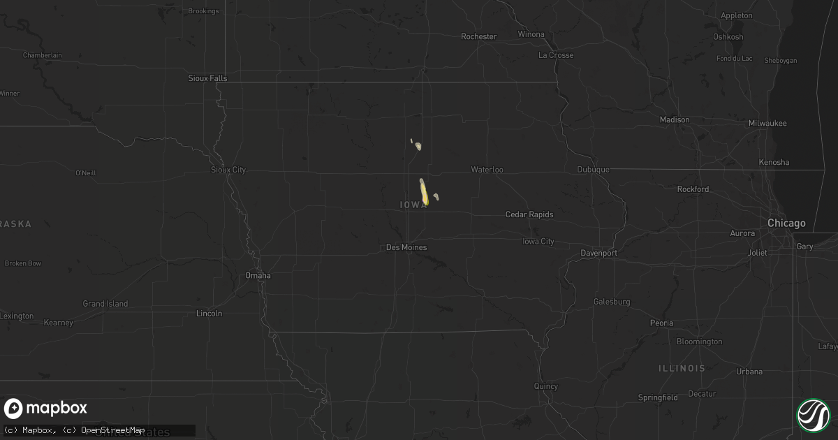
Hail Map in Iowa on August 11, 2022
Get this storm
August 11 map
$229
one time, instant access
Download today. No call, no setup
Keep the $229
Bought the map and want the full workflow? Apply the entire $229 to a subscription within 7 days. None of it is wasted.
Every map, not just this one
This buys you this map. Subscription and you get every map we run, in the markets you choose from a few cities to whole states to nationwide. Plus real-time alerts the moment a storm fires.
Contact data
Name, contact info, occupancy, even credit band for addresses in the footprint. You go from where it hit to who to call.
Become the source they trust
Unlimited branding weather history reports on demand. You already have the documented answer ready for the property owner, and you are the one who showed up with it.
Property data and RoofTrace estimates
Pull up any address you have got, its value and the exact code rules for that jurisdiction, straight from One Click Code. Then RoofTrace estimates the squares, pitch, and roof value, priced the way you price.
Storm reports in Iowa
Iowa
| Date | Description |
|---|---|
| 08/11/20222:06 PM CDT | Pictures of damaging to siding and roofs. Consistent with damage from wind driven hail. |
| 08/11/20222:05 PM CDT | 1 to 2 inch diameter tree limbs down along with larger older branches. |
| 08/11/20222:05 PM CDT | Some roof/shingle damage... Widespread tree damage... A few windows blown out in town. Hail was piled up several inches in some parts of town. |
| 08/11/20222:03 PM CDT | Largest hail at the time with hail still ongoing. |
| 08/11/20222:03 PM CDT | A local report indicates 1.25 inch wind near 1 NNW ZEARING |
| 08/10/20228:46 PM CDT | At 146 PM CDT, a severe thunderstorm was located 12 miles southwest of Eldora, moving southeast at 35 mph. HAZARD...60 mph wind gusts and quarter size hail. SOURCE...Radar indicated. IMPACT...Hail damage to vehicles is expected. Expect wind damage to roofs, siding, and trees. This severe thunderstorm will be near... New Providence around 150 PM CDT. McCallsburg around 155 PM CDT. Zearing around 200 PM CDT. St. Anthony around 205 PM CDT.Other locations in the path of this severe thunderstorm includeClemons and State Center. |
All States Impacted by Hail Map on August 11, 2022
Cities Impacted by Hail Map on August 11, 2022
- Daniel, WY
- Ten Sleep, WY
- Colfax, WA
- Pullman, WA
- Edinburg, TX
- Mission, TX
- Worley, ID
- Otis Orchards, WA
- Rathdrum, ID
- Latah, WA
- Newman Lake, WA
- Fairfield, WA
- Oakesdale, WA
- Greenacres, WA
- Liberty Lake, WA
- Tekoa, WA
- Post Falls, ID
- Coeur D Alene, ID
- Mica, WA
- Plummer, ID
- Rockford, WA
- Kamiah, ID
- Greencreek, ID
- Nezperce, ID
- Cottonwood, ID
- Ferdinand, ID
- La Grande, OR
- Parma, ID
- Alexander, IA
- Belmond, IA
- Rocksprings, TX
- Nordman, ID
- Tombstone, AZ
- Hereford, AZ
- Culdesac, ID
- Lenore, ID
- Murphy, ID
- George West, TX
- Elgin, OR
- Colo, IA
- Hubbard, IA
- Radcliffe, IA
- Zearing, IA
- Alden, IA
- McCallsburg, IA
- Lewiston, ID
- Wallowa, OR
- Enterprise, OR
- Summerville, OR
- Cove, OR
- Imbler, OR
- Cary, NC
- Raleigh, NC
- Kenedy, TX
- Craigmont, ID
- Weippe, ID
- Homedale, ID
- Marsing, ID
- Grangeville, ID
- Pierce, ID
- Lake Mary, FL
- Goliad, TX
- Oldtown, ID
- Blanchard, ID
- White Bird, ID
- Savannah, GA
- Caldwell, ID
- Peck, ID
- Winchester, ID
- Imnaha, OR
- Evanston, WY
- Frenchville, ME
- Madawaska, ME
- Swaledale, IA
- Alzada, MT
- Moab, UT
- Coalville, UT
- Britt, IA
- Fruitland, ID
- New Plymouth, ID
- Wilder, ID
- Fort Myers, FL
- Latimer, IA
- Saint Maries, ID
- Pomeroy, WA
- Eureka, UT
- Stockton, UT
- Park City, UT
- New Providence, IA
- Clemons, IA
- Union, IA
- Millwood, GA
- Axson, GA
- Nicholls, GA
- Bonners Ferry, ID


