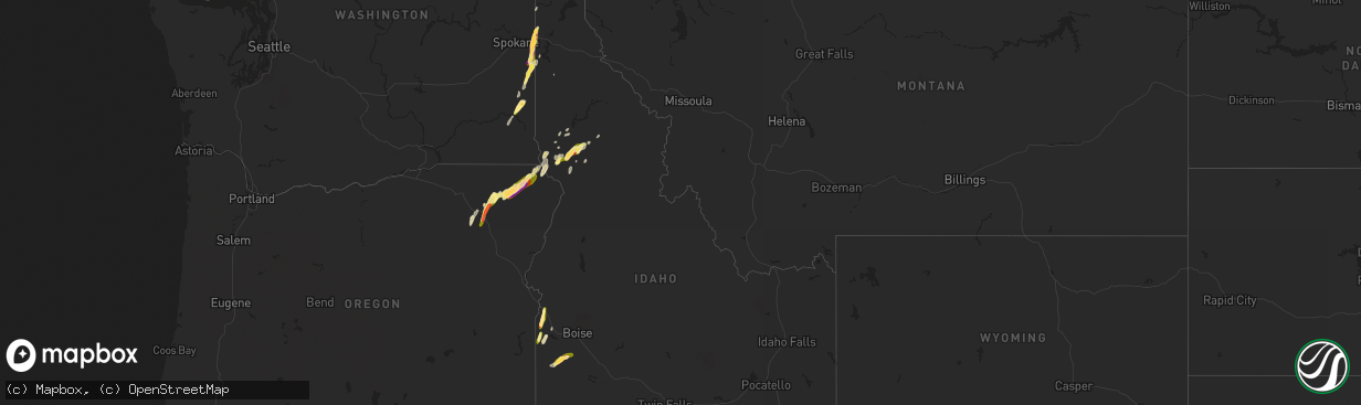
Hail Map in Idaho on August 11, 2022
The weather event in Idaho on August 11, 2022 includes Hail and Wind maps. 13 states and 95 cities were impacted and suffered possible damage. The total estimated number of properties impacted is 6,282.
Want more than just the map?
Turn this storm into a full workflow.
- Owner + property data so you know who to knock
- OnDemand branded weather history reports to win the "did we even have hail?" argument
- RoofTrace estimate so reps stop guessing numbers at the door
Bought this map? Upgrade within 7 days and we'll credit the $230. (10-15 min setup call)
Hail
Wind
6,282
Estimated number of impacted properties by a 1.00" hail or larger2,907
Estimated number of impacted properties by a 1.75" hail or larger1,197
Estimated number of impacted properties by a 2.50" hail or largerStorm reports in Idaho
Idaho
| Date | Description |
|---|---|
| 08/11/20226:25 PM CDT | Via social media. Time is estimated from radar. |
| 08/11/20226:25 PM CDT | 3 trees blown down. Via social media. Time estimated based on radar. |
| 08/11/20226:25 PM CDT | A local report indicates 1.50 inch wind near 4 SW MURPHY |
| 08/11/20226:24 PM CDT | Via social media. Time estimated. |
| 08/11/20226:20 PM CDT | A weather spotter heard that multiple trees were down on beaverslide road. |
| 08/11/20226:16 PM CDT | Downed trees on a residential property in kamiah. Report via social media. Time estimated from radar. |
| 08/11/20226:15 PM CDT | Trees and power lines down in the town of kamiah. |
| 08/11/20226:15 PM CDT | Trees down over state route 64 between milepost 28 to 30. |
| 08/11/20226:15 PM CDT | Corrects previous tstm wnd dmg report from kamiah. Trees and power lines down in the town of kamiah. Roof detached from in kamiah and landed on a car. |
| 08/11/20226:15 PM CDT | Tree branches down over highway 162 between milepost 21 and 22. |
| 08/11/20226:15 PM CDT | Trees down over highway 12 between mile post 60 and 66. |
| 08/11/20226:10 PM CDT | Several large trees downed. |
| 08/11/20226:03 PM CDT | Downed power lines and power outages east of nezperce. Time estimated from radar. |
| 08/11/20225:55 PM CDT | Time estimated from radar. |
| 08/11/20222:15 AM CDT | Mesonet station lof - inl specific manufacturing. Convective outflow. |
| 08/11/202212:36 AM CDT | At 535 PM MDT, a severe thunderstorm was located near Homedale, or 17 miles southwest of Caldwell, moving north at 20 mph. HAZARD...60 mph wind gusts and quarter size hail. SOURCE...Radar indicated. IMPACT...Hail damage to vehicles is expected. Expect wind damage to roofs, siding, and trees. This severe thunderstorm will be near... Homedale around 550 PM MDT. Parma, Wilder, Greenleaf and Notus around 610 PM MDT. |
| 08/11/202212:12 AM CDT | At 511 PM MDT, a severe thunderstorm was located over Murphy, or 26 miles south of Nampa, moving northeast at 30 mph. HAZARD...60 mph wind gusts and quarter size hail. SOURCE...Radar indicated. IMPACT...Hail damage to vehicles is expected. Expect wind damage to roofs, siding, and trees. This severe thunderstorm will be near... Swan Falls around 530 PM MDT. Initial Point and Big Foot Butte around 540 PM MDT. Kuna around 550 PM MDT. |
| 08/10/202211:49 PM CDT | At 448 PM MDT, a severe thunderstorm was located over Parma, moving north at 30 mph. HAZARD...60 mph wind gusts and quarter size hail. SOURCE...Radar indicated. IMPACT...Hail damage to vehicles is expected. Expect wind damage to roofs, siding, and trees. This severe thunderstorm will be near... Parma around 450 PM MDT. Nyssa and Owyhee around 500 PM MDT. Fruitland and New Plymouth around 520 PM MDT. Ontario and Payette around 530 PM MDT. |
| 08/10/202211:49 PM CDT | At 448 PM PDT, a severe thunderstorm was located 8 miles west of Grangeville, moving north at 30 mph. HAZARD...60 mph wind gusts and hail up to 1 inch. SOURCE...Radar indicated. IMPACT...Expect damage to roofs, siding, and trees. Locations impacted include... Cottonwood, Ferdinand, Winona and Fenn. |
| 08/10/202211:29 PM CDT | At 428 PM PDT, a severe thunderstorm was located near Weippe, or 13 miles northeast of Kamiah, moving northeast at 25 mph. HAZARD...60 mph wind gusts and half dollar size hail. SOURCE...Radar indicated. IMPACT...Hail damage to vehicles is expected. Expect wind damage to roofs, siding, and trees. Locations impacted include... Pierce, Weippe and Musselshell. |
| 08/10/202211:27 PM CDT | At 427 PM MDT, a severe thunderstorm was located near Marsing, or 13 miles southwest of Caldwell, moving north at 20 mph. HAZARD...60 mph wind gusts and quarter size hail. SOURCE...Radar indicated. IMPACT...Hail damage to vehicles is expected. Expect wind damage to roofs, siding, and trees. This severe thunderstorm will be near... Marsing around 430 PM MDT. Homedale around 440 PM MDT. Wilder and Huston around 450 PM MDT. Caldwell, Greenleaf and Sand Hollow around 500 PM MDT. Notus around 510 PM MDT. |
| 08/10/202211:25 PM CDT | At 424 AM PDT, a severe thunderstorm was located 14 miles northwest of Nordman, or 38 miles west of Bonners Ferry, moving northeast at 25 mph. HAZARD...Ping pong ball size hail and 60 mph wind gusts. SOURCE...Radar indicated. IMPACT...Expect hail damage to roofs, siding, windows, and vehicles. Expect wind damage to roofs, siding, and trees. This severe thunderstorm will remain over mainly rural areas of northwestern Boundary, northwestern Bonner and northeastern Pend Oreille Counties. |
| 08/10/202211:00 PM CDT | At 359 PM PDT, a severe thunderstorm was located over Nezperce, or 9 miles west of Kamiah, moving northeast at 20 mph. HAZARD...Ping pong ball size hail and 60 mph wind gusts. SOURCE...Radar indicated. IMPACT...People and animals outdoors will be injured. Expect hail damage to roofs, siding, windows, and vehicles. Expect wind damage to roofs, siding, and trees. Locations impacted include... East Kamiah, Pardee and Woodland. |
| 08/10/202210:54 PM CDT | At 354 PM PDT, a severe thunderstorm was located near Colfax, or 10 miles northwest of Pullman, moving northeast at 40 mph. HAZARD...60 mph wind gusts and quarter size hail. SOURCE...Radar indicated. IMPACT...Hail damage to vehicles is expected. Expect wind damage to roofs, siding, and trees. Locations impacted include... Colfax, Palouse, Garfield, Albion, Oakesdale, Farmington and Belmont. |
| 08/10/202210:49 PM CDT | At 348 PM PDT, a severe thunderstorm was located near Nezperce, or 13 miles west of Kamiah, moving northeast at 35 mph. HAZARD...Tennis ball size hail and 60 mph wind gusts. SOURCE...Radar indicated. IMPACT...People and animals outdoors will be injured. Expect hail damage to roofs, siding, windows, and vehicles. Expect wind damage to roofs, siding, and trees. Locations impacted include... Nezperce and Mohler. This includes the following highways... U.S. Highway 95 in Idaho near mile marker 269. U.S. Highway 12 in Idaho between mile markers 52 and 54, and betweenmile markers 59 and 60. |
| 08/10/202210:27 PM CDT | At 326 PM PDT, a severe thunderstorm was located near Craigmont, or 19 miles west of Kamiah, moving northeast at 30 mph. HAZARD...60 mph wind gusts and quarter size hail. SOURCE...Radar indicated. IMPACT...Hail damage to vehicles is expected. Expect wind damage to roofs, siding, and trees. Locations impacted include... Orofino, Ferdinand, Ahsahka, Greer, Pardee, Woodland and Riverside. |
| 08/10/20228:05 PM CDT | Report from mping: quarter |
| 08/10/20228:04 PM CDT | Golf ball sized hail on the south shore of hauser lake. Time estimated from radar. |
| 08/10/20228:04 PM CDT | Mping report. Time estimated from radar. |
| 08/10/20228:01 PM CDT | Report and photo via social media. Time estimated from radar. |
| 08/10/20227:53 PM CDT | Several reports of power outages and downed lines west and southwest of eddyville and near carlin bay airport. Time estimated from radar. |
| 08/10/20227:01 PM CDT | 1/2 hail reported; thunderstorm powerline wind damage. |
| 08/10/20227:00 PM CDT | Gusty winds with thunderstorms brought down trees in the area. Estimated pea size hail. |
All States Impacted by Hail Map on August 11, 2022
Cities Impacted by Hail Map on August 11, 2022
- Daniel, WY
- Ten Sleep, WY
- Colfax, WA
- Pullman, WA
- Edinburg, TX
- Mission, TX
- Worley, ID
- Otis Orchards, WA
- Rathdrum, ID
- Latah, WA
- Newman Lake, WA
- Fairfield, WA
- Oakesdale, WA
- Greenacres, WA
- Liberty Lake, WA
- Tekoa, WA
- Post Falls, ID
- Coeur D Alene, ID
- Mica, WA
- Plummer, ID
- Rockford, WA
- Kamiah, ID
- Greencreek, ID
- Nezperce, ID
- Cottonwood, ID
- Ferdinand, ID
- La Grande, OR
- Parma, ID
- Alexander, IA
- Belmond, IA
- Rocksprings, TX
- Nordman, ID
- Tombstone, AZ
- Hereford, AZ
- Culdesac, ID
- Lenore, ID
- Murphy, ID
- George West, TX
- Elgin, OR
- Colo, IA
- Hubbard, IA
- Radcliffe, IA
- Zearing, IA
- Alden, IA
- McCallsburg, IA
- Lewiston, ID
- Wallowa, OR
- Enterprise, OR
- Summerville, OR
- Cove, OR
- Imbler, OR
- Cary, NC
- Raleigh, NC
- Kenedy, TX
- Craigmont, ID
- Weippe, ID
- Homedale, ID
- Marsing, ID
- Grangeville, ID
- Pierce, ID
- Lake Mary, FL
- Goliad, TX
- Oldtown, ID
- Blanchard, ID
- White Bird, ID
- Savannah, GA
- Caldwell, ID
- Peck, ID
- Winchester, ID
- Imnaha, OR
- Evanston, WY
- Frenchville, ME
- Madawaska, ME
- Swaledale, IA
- Alzada, MT
- Moab, UT
- Coalville, UT
- Britt, IA
- Fruitland, ID
- New Plymouth, ID
- Wilder, ID
- Fort Myers, FL
- Latimer, IA
- Saint Maries, ID
- Pomeroy, WA
- Eureka, UT
- Stockton, UT
- Park City, UT
- New Providence, IA
- Clemons, IA
- Union, IA
- Millwood, GA
- Axson, GA
- Nicholls, GA
- Bonners Ferry, ID


