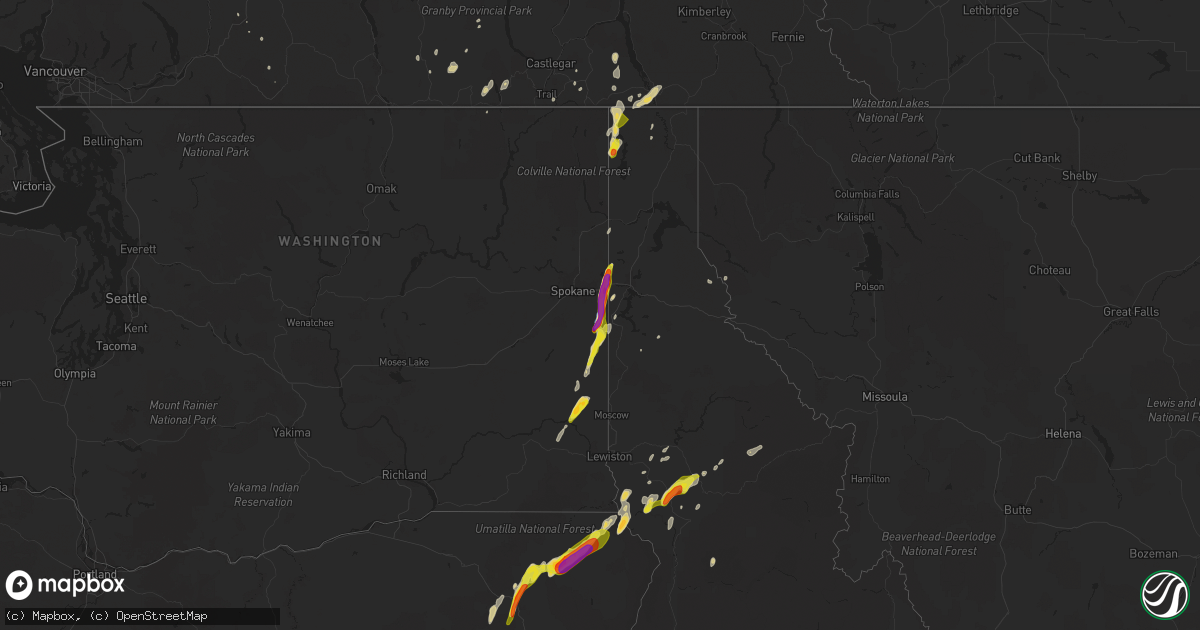
Hail Map on August 11, 2022
Get this storm
August 11 map
$229
one time, instant access
Download today. No call, no setup
Keep the $229
Bought the map and want the full workflow? Apply the entire $229 to a subscription within 7 days. None of it is wasted.
Every map, not just this one
This buys you this map. Subscription and you get every map we run, in the markets you choose from a few cities to whole states to nationwide. Plus real-time alerts the moment a storm fires.
Contact data
Name, contact info, occupancy, even credit band for addresses in the footprint. You go from where it hit to who to call.
Become the source they trust
Unlimited branding weather history reports on demand. You already have the documented answer ready for the property owner, and you are the one who showed up with it.
Property data and RoofTrace estimates
Pull up any address you have got, its value and the exact code rules for that jurisdiction, straight from One Click Code. Then RoofTrace estimates the squares, pitch, and roof value, priced the way you price.
States Impacted by Hail Map on August 11, 2022
Storm reports
Oregon
| Date | Description |
|---|---|
| 08/11/20226:15 PM CDT | Via social media. |
| 08/11/20226:01 PM CDT | Corrects previous tstm wnd gst report from 1 w lostine. Via call: lost power 20 minutes ago. Some trees down and bent. No precip reported. |
| 08/11/20225:50 PM CDT | *** 4 inj *** corrects previous hail report from wallowa. Corrects previous hail report from wallowa. Golf ball sized hail and 4 injuries reported. County without power |
| 08/11/20225:50 PM CDT | *** 1 inj *** golf ball sized hail and multiple injuries reported. County without power. |
| 08/11/20225:45 PM CDT | Hail larger than an inch... Shredded sunshade... And no power. |
| 08/11/20225:00 PM CDT | Spotter in imbler got hail ranging from 0.78 to 1.25. Also recorded 0.17 rain accumulation for the event. |
| 08/11/20224:50 PM CDT | Radar estimated time. Received facebook report of hail stones larger than a quarter. |
| 08/11/20224:49 PM CDT | Awos station klgd la grande/union county airport. |
| 08/10/202210:59 PM CDT | At 358 PM PDT, a severe thunderstorm was located 9 miles northeast of Wallowa, or 16 miles north of Enterprise, moving northeast at 40 mph. HAZARD...Two inch hail and 60 mph wind gusts. SOURCE...Radar indicated. IMPACT...People and animals outdoors will be injured. Expect hail damage to roofs, siding, windows, and vehicles. Expect wind damage to roofs, siding, and trees. Locations impacted include... Wallowa, Imnaha, Flora and Paradise. |
| 08/10/202210:21 PM CDT | At 321 PM PDT, a severe thunderstorm was located 7 miles southeast of Elgin, or 18 miles northeast of La Grande, moving northeast at 35 mph. HAZARD...60 mph wind gusts and half dollar size hail. SOURCE...Radar indicated. IMPACT...Hail damage to vehicles is expected. Expect wind damage to roofs, siding, and trees. Locations impacted include... Elgin, Wallowa and Minam. |
| 08/10/20229:56 PM CDT | At 255 PM PDT, a severe thunderstorm was located 21 miles east of Paradise, or 31 miles south of Lapwai, moving northeast at 25 mph. HAZARD...Ping pong ball size hail and 60 mph wind gusts. SOURCE...Radar indicated. IMPACT...People and animals outdoors will be injured. Expect hail damage to roofs, siding, windows, and vehicles. Expect wind damage to roofs, siding, and trees. This severe thunderstorm will remain over mainly rural areas of south central Nez Perce and southwestern Lewis Counties. |
| 08/10/20229:52 PM CDT | At 252 PM PDT, a severe thunderstorm was located over Island City, or over La Grande, moving north at 30 mph. HAZARD...60 mph wind gusts and half dollar size hail. SOURCE...Radar indicated. IMPACT...Hail damage to vehicles is expected. Expect wind damage to roofs, siding, and trees. Locations impacted include... La Grande, Elgin, Island City, Imbler and Summerville. |
Arizona
| Date | Description |
|---|---|
| 08/11/20221:06 AM CDT | At 606 PM MST, a severe thunderstorm was located 12 miles northeast of Bouse, or 21 miles southwest of Alamo Lake, and is nearly stationary. HAZARD...60 mph wind gusts. SOURCE...Radar indicated. IMPACT...Expect damage to roofs, siding, and trees. This severe thunderstorm will remain over mainly rural areas of north central La Paz County. |
| 08/11/202212:48 AM CDT | At 548 PM MST, a severe thunderstorm was located 10 miles east of Alamo State Park, or 10 miles east of Alamo Lake, and is nearly stationary. HAZARD...60 mph wind gusts. SOURCE...Radar indicated. IMPACT...Expect damage to roofs, siding, and trees. This severe thunderstorm will remain over mainly rural areas of northeastern La Paz County. |
| 08/10/202211:55 PM CDT | At 455 PM MST, a severe thunderstorm was located near Hereford, or near Sierra Vista, moving northwest at 10 mph. HAZARD...60 mph wind gusts and quarter size hail. SOURCE...Radar indicated. IMPACT...Hail damage to vehicles is expected. Expect wind damage to roofs, siding, and trees. Locations impacted include... Sierra Vista, Hereford, Huachuca City, Fort Huachuca, Ramsey Canyon Preserve and Coronado National Memorial. |
| 08/10/202211:54 PM CDT | At 454 PM MST, a severe thunderstorm was located near Tombstone, or 10 miles northeast of Sierra Vista, moving northwest at 15 mph. HAZARD...60 mph wind gusts and quarter size hail. SOURCE...Radar indicated. IMPACT...Hail damage to vehicles is expected. Expect wind damage to roofs, siding, and trees. Locations impacted include... Whetstone, Huachuca City, Tombstone, Fairbank and Charleston. |
| 08/10/202211:50 PM CDT | At 450 PM MST, a severe thunderstorm was located over Gold Canyon, moving northwest at 10 mph. HAZARD...60 mph wind gusts. SOURCE...Radar indicated. IMPACT...Expect damage to roofs, siding, and trees. Locations impacted include... Apache Junction, Gold Canyon, Kings Ranch, Lost Dutchman State Park, Superstition Mountains and Gold Camp.This includes US Highway 60 between mile markers 196 and 209. |
| 08/10/202211:10 PM CDT | At 410 PM MST, a severe thunderstorm was located over Kingman, moving south at 10 mph. HAZARD...60 mph wind gusts and quarter size hail. SOURCE...Radar indicated. IMPACT...Hail damage to vehicles is expected. Expect wind damage to roofs and trees. Locations impacted include... Kingman, Wild Cow Campground, New Kingman-Butler, Hualapai Mountain Park and Hualapai Peak.This includes Interstate 40 in Arizona between mile markers 38 and61. |
| 08/10/202211:03 PM CDT | At 403 PM MST, a severe thunderstorm was located near Dragoon, or 14 miles southwest of Willcox, moving southwest at 15 mph. HAZARD...60 mph wind gusts and quarter size hail. SOURCE...Radar indicated. IMPACT...Hail damage to vehicles is expected. Expect wind damage to roofs, siding, and trees. Locations impacted include... Texas Canyon. |
| 08/10/202210:44 PM CDT | At 344 PM MST, a severe thunderstorm was located near Top-Of-The-World, or 8 miles north of Superior, and is nearly stationary. HAZARD...60 mph wind gusts. SOURCE...Radar indicated. IMPACT...Expect damage to roofs, siding, and trees. This severe thunderstorm will remain over mainly rural areas of Gila and Pinal Counties. |
| 08/10/202210:01 PM CDT | At 301 PM MST, a severe thunderstorm was located near Top-Of-The-World, or 9 miles northeast of Superior, and is nearly stationary. HAZARD...60 mph wind gusts. SOURCE...Radar indicated. IMPACT...Expect damage to roofs, siding, and trees. This severe thunderstorm will remain over mainly rural areas of Gila and Pinal Counties. |
| 08/10/20229:53 PM CDT | At 253 PM MST, a severe thunderstorm was located near Four Peaks, or 7 miles east of Ballantine Trailhead, moving northwest at 10 mph. HAZARD...60 mph wind gusts. SOURCE...Radar indicated. IMPACT...Expect damage to roofs, siding, and trees. Locations impacted include... Ballantine Trailhead, Four Peaks and Tonto Basin. This includes AZ Route 87 between mile markers 210 and 211. |
California
| Date | Description |
|---|---|
| 08/11/202212:45 AM CDT | At 545 PM PDT, a severe thunderstorm was located 16 miles northeast of Desert Center, and is nearly stationary. HAZARD...60 mph wind gusts. SOURCE...Radar indicated. IMPACT...Expect damage to roofs, siding, and trees. This severe thunderstorm will remain over mainly rural areas of Riverside County.This includes CA Route 177 between mile markers 8 and 22. |
| 08/10/202211:13 PM CDT | At 413 PM PDT, a severe thunderstorm was located 18 miles southeast of Desert Center, and is nearly stationary. HAZARD...60 mph wind gusts. SOURCE...Radar indicated. IMPACT...Expect damage to roofs, siding, and trees. This severe thunderstorm will remain over mainly rural areas of Riverside County. |
| 08/10/20227:20 PM CDT | Wind damage to a boat storage center. Large sections of roofing and siding torn off of storage units. |
Maine
| Date | Description |
|---|---|
| 08/11/20222:00 PM CDT | Tree down causing a power outage near madawaska. |
Idaho
| Date | Description |
|---|---|
| 08/11/20226:25 PM CDT | Via social media. Time is estimated from radar. |
| 08/11/20226:25 PM CDT | 3 trees blown down. Via social media. Time estimated based on radar. |
| 08/11/20226:25 PM CDT | A local report indicates 1.50 inch wind near 4 SW MURPHY |
| 08/11/20226:24 PM CDT | Via social media. Time estimated. |
| 08/11/20226:20 PM CDT | A weather spotter heard that multiple trees were down on beaverslide road. |
| 08/11/20226:16 PM CDT | Downed trees on a residential property in kamiah. Report via social media. Time estimated from radar. |
| 08/11/20226:15 PM CDT | Trees down over state route 64 between milepost 28 to 30. |
| 08/11/20226:15 PM CDT | Tree branches down over highway 162 between milepost 21 and 22. |
| 08/11/20226:15 PM CDT | Trees down over highway 12 between mile post 60 and 66. |
| 08/11/20226:15 PM CDT | Trees and power lines down in the town of kamiah. |
| 08/11/20226:15 PM CDT | Corrects previous tstm wnd dmg report from kamiah. Trees and power lines down in the town of kamiah. Roof detached from in kamiah and landed on a car. |
| 08/11/20226:10 PM CDT | Several large trees downed. |
| 08/11/20226:03 PM CDT | Downed power lines and power outages east of nezperce. Time estimated from radar. |
| 08/11/20225:55 PM CDT | Time estimated from radar. |
| 08/11/20222:15 AM CDT | Mesonet station lof - inl specific manufacturing. Convective outflow. |
| 08/11/202212:36 AM CDT | At 535 PM MDT, a severe thunderstorm was located near Homedale, or 17 miles southwest of Caldwell, moving north at 20 mph. HAZARD...60 mph wind gusts and quarter size hail. SOURCE...Radar indicated. IMPACT...Hail damage to vehicles is expected. Expect wind damage to roofs, siding, and trees. This severe thunderstorm will be near... Homedale around 550 PM MDT. Parma, Wilder, Greenleaf and Notus around 610 PM MDT. |
| 08/11/202212:12 AM CDT | At 511 PM MDT, a severe thunderstorm was located over Murphy, or 26 miles south of Nampa, moving northeast at 30 mph. HAZARD...60 mph wind gusts and quarter size hail. SOURCE...Radar indicated. IMPACT...Hail damage to vehicles is expected. Expect wind damage to roofs, siding, and trees. This severe thunderstorm will be near... Swan Falls around 530 PM MDT. Initial Point and Big Foot Butte around 540 PM MDT. Kuna around 550 PM MDT. |
| 08/10/202211:49 PM CDT | At 448 PM PDT, a severe thunderstorm was located 8 miles west of Grangeville, moving north at 30 mph. HAZARD...60 mph wind gusts and hail up to 1 inch. SOURCE...Radar indicated. IMPACT...Expect damage to roofs, siding, and trees. Locations impacted include... Cottonwood, Ferdinand, Winona and Fenn. |
| 08/10/202211:49 PM CDT | At 448 PM MDT, a severe thunderstorm was located over Parma, moving north at 30 mph. HAZARD...60 mph wind gusts and quarter size hail. SOURCE...Radar indicated. IMPACT...Hail damage to vehicles is expected. Expect wind damage to roofs, siding, and trees. This severe thunderstorm will be near... Parma around 450 PM MDT. Nyssa and Owyhee around 500 PM MDT. Fruitland and New Plymouth around 520 PM MDT. Ontario and Payette around 530 PM MDT. |
| 08/10/202211:29 PM CDT | At 428 PM PDT, a severe thunderstorm was located near Weippe, or 13 miles northeast of Kamiah, moving northeast at 25 mph. HAZARD...60 mph wind gusts and half dollar size hail. SOURCE...Radar indicated. IMPACT...Hail damage to vehicles is expected. Expect wind damage to roofs, siding, and trees. Locations impacted include... Pierce, Weippe and Musselshell. |
| 08/10/202211:27 PM CDT | At 427 PM MDT, a severe thunderstorm was located near Marsing, or 13 miles southwest of Caldwell, moving north at 20 mph. HAZARD...60 mph wind gusts and quarter size hail. SOURCE...Radar indicated. IMPACT...Hail damage to vehicles is expected. Expect wind damage to roofs, siding, and trees. This severe thunderstorm will be near... Marsing around 430 PM MDT. Homedale around 440 PM MDT. Wilder and Huston around 450 PM MDT. Caldwell, Greenleaf and Sand Hollow around 500 PM MDT. Notus around 510 PM MDT. |
| 08/10/202211:25 PM CDT | At 424 AM PDT, a severe thunderstorm was located 14 miles northwest of Nordman, or 38 miles west of Bonners Ferry, moving northeast at 25 mph. HAZARD...Ping pong ball size hail and 60 mph wind gusts. SOURCE...Radar indicated. IMPACT...Expect hail damage to roofs, siding, windows, and vehicles. Expect wind damage to roofs, siding, and trees. This severe thunderstorm will remain over mainly rural areas of northwestern Boundary, northwestern Bonner and northeastern Pend Oreille Counties. |
| 08/10/202211:00 PM CDT | At 359 PM PDT, a severe thunderstorm was located over Nezperce, or 9 miles west of Kamiah, moving northeast at 20 mph. HAZARD...Ping pong ball size hail and 60 mph wind gusts. SOURCE...Radar indicated. IMPACT...People and animals outdoors will be injured. Expect hail damage to roofs, siding, windows, and vehicles. Expect wind damage to roofs, siding, and trees. Locations impacted include... East Kamiah, Pardee and Woodland. |
| 08/10/202210:54 PM CDT | At 354 PM PDT, a severe thunderstorm was located near Colfax, or 10 miles northwest of Pullman, moving northeast at 40 mph. HAZARD...60 mph wind gusts and quarter size hail. SOURCE...Radar indicated. IMPACT...Hail damage to vehicles is expected. Expect wind damage to roofs, siding, and trees. Locations impacted include... Colfax, Palouse, Garfield, Albion, Oakesdale, Farmington and Belmont. |
| 08/10/202210:49 PM CDT | At 348 PM PDT, a severe thunderstorm was located near Nezperce, or 13 miles west of Kamiah, moving northeast at 35 mph. HAZARD...Tennis ball size hail and 60 mph wind gusts. SOURCE...Radar indicated. IMPACT...People and animals outdoors will be injured. Expect hail damage to roofs, siding, windows, and vehicles. Expect wind damage to roofs, siding, and trees. Locations impacted include... Nezperce and Mohler. This includes the following highways... U.S. Highway 95 in Idaho near mile marker 269. U.S. Highway 12 in Idaho between mile markers 52 and 54, and betweenmile markers 59 and 60. |
| 08/10/202210:27 PM CDT | At 326 PM PDT, a severe thunderstorm was located near Craigmont, or 19 miles west of Kamiah, moving northeast at 30 mph. HAZARD...60 mph wind gusts and quarter size hail. SOURCE...Radar indicated. IMPACT...Hail damage to vehicles is expected. Expect wind damage to roofs, siding, and trees. Locations impacted include... Orofino, Ferdinand, Ahsahka, Greer, Pardee, Woodland and Riverside. |
| 08/10/20228:05 PM CDT | Report from mping: quarter |
| 08/10/20228:04 PM CDT | Golf ball sized hail on the south shore of hauser lake. Time estimated from radar. |
| 08/10/20228:04 PM CDT | Mping report. Time estimated from radar. |
| 08/10/20228:01 PM CDT | Report and photo via social media. Time estimated from radar. |
| 08/10/20227:53 PM CDT | Several reports of power outages and downed lines west and southwest of eddyville and near carlin bay airport. Time estimated from radar. |
| 08/10/20227:01 PM CDT | 1/2 hail reported; thunderstorm powerline wind damage. |
| 08/10/20227:00 PM CDT | Gusty winds with thunderstorms brought down trees in the area. Estimated pea size hail. |
Wyoming
| Date | Description |
|---|---|
| 08/11/20224:15 PM CDT | Photo of nickel to quarter size hail received from em. |
Florida
| Date | Description |
|---|---|
| 08/11/20221:00 PM CDT | Delayed report. Public posted a video on twitter of a large tree down in north jacksonville beach blocking the road on the intersection of 9th ave and 9th st. |
| 08/11/20227:46 AM CDT | At 1246 PM EDT, a severe thunderstorm was located near Ratliff, or 7 miles west of Jacksonville International Arpt, moving northeast at 15 mph. HAZARD...60 mph wind gusts. SOURCE...Radar indicated. IMPACT...Expect damage to roofs, siding, and trees. Locations impacted include... Jacksonville International Arpt, Ratliff and Nassau Village-Ratliff. |
| 08/11/20225:36 AM CDT | At 1036 AM EDT/936 AM CDT/, a severe thunderstorm was located 9 miles south of Port St. Joe, moving east at 20 mph. HAZARD...60 mph wind gusts. SOURCE...Radar indicated. IMPACT...Expect damage to roofs, siding, and trees. Locations impacted include... Nine Mile, Eleven Mile, Thirteen Mile, Odena and Indian Pass. |
| 08/10/20229:15 PM CDT | At 214 PM EDT, a severe thunderstorm was located over Lake Mary, moving north at 5 mph. HAZARD...60 mph wind gusts. SOURCE...Radar indicated. IMPACT...Expect damage to roofs, siding, and trees. Locations impacted include... Sanford, Altamonte Springs, Winter Springs, Casselberry and Lake Mary. |
| 08/10/20228:11 PM CDT | At 111 PM EDT, a severe thunderstorm was located over Riverside, or over Jacksonville, and is nearly stationary. HAZARD...60 mph wind gusts and nickel size hail. SOURCE...Radar indicated. IMPACT...Expect damage to roofs, siding, and trees. Locations impacted include... Jacksonville, Arlington, Baymeadows, Ortega, San Marco, Riverside and Tallyrand. |
Utah
| Date | Description |
|---|---|
| 08/10/20229:57 PM CDT | At 257 PM MDT, a severe thunderstorm was located over North Snyderville Basin, or 8 miles north of Park City, moving north at 15 mph. HAZARD...60 mph wind gusts and quarter size hail. SOURCE...Radar indicated. IMPACT...Hail damage to vehicles is expected. Expect wind damage to roofs, siding, and trees. Locations impacted include... Coalville, Summit Park, North Snyderville Basin, East Canyon State Park, South Snyderville Basin and Echo Reservoir.This includes the following highways... Interstate 80 in Utah between mile markers 141 and 143, between milemarkers 146 and 147, between mile markers 150 and 154, and betweenmile markers 160 and 164. US Route 40 near mile marker 0. |
| 08/10/20228:10 PM CDT | Thunderstorm wind gusts estimated to be between 55-60 mph caused significant roof damage in the navajo ridge neighborhood outside moab. Solar panels were damaged. |
| 08/10/20227:50 PM CDT | Sundance arrowhead weather station |
Georgia
| Date | Description |
|---|---|
| 08/11/20227:47 AM CDT | At 1247 PM EDT, a severe thunderstorm was located near Dixie Union, or 9 miles south of Alma, moving northeast at 40 mph. HAZARD...60 mph wind gusts. SOURCE...Radar indicated. IMPACT...Expect damage to roofs, siding, and trees. Locations impacted include... Alma, Nicholls, Dixie Union and Bickley. |
| 08/11/20227:32 AM CDT | At 1231 PM EDT, a severe thunderstorm was located near Cogdell, or 9 miles north of Argyle, moving northeast at 25 mph. HAZARD...60 mph wind gusts. SOURCE...Radar indicated. IMPACT...Expect damage to roofs, siding, and trees. Locations impacted include... Dixie Union, Pebble Hill, Millwood and Axson. |
Texas
| Date | Description |
|---|---|
| 08/11/20222:49 AM CDT | At 748 PM CDT, a severe thunderstorm was located near River Creek Acres, or near George West, moving south at 15 mph. HAZARD...Quarter size hail. SOURCE...Radar indicated. IMPACT...Damage to vehicles is expected. Locations impacted include... George West, Midway, River Creek Acres, Annarose and Clegg. This includes the following highways... US Highway 281 between mile markers 634 and 654. US Highway 59 between mile markers 724 and 736. |
| 08/11/20222:03 AM CDT | At 703 PM CDT, a severe thunderstorm was located over Pawnee, or 13 miles northeast of Three Rivers, moving south at 20 mph. HAZARD...60 mph wind gusts and quarter size hail. SOURCE...Radar indicated. IMPACT...Hail damage to vehicles is expected. Expect wind damage to roofs, siding, and trees. Locations impacted include... George West, Three Rivers, Oakville, Pawnee, Ray Point and Karon. This includes the following highways... Interstate 37 between mile markers 54 and 74. US Highway 281 between mile markers 618 and 630. US Highway 59 between mile markers 710 and 722. |
| 08/11/20221:44 AM CDT | At 644 PM CDT, a severe thunderstorm was located near Citrus City, or near Palmhurst, moving southwest at 25 mph. HAZARD...60 mph wind gusts and half dollar size hail. SOURCE...Radar indicated. IMPACT...Hail damage to vehicles is expected. Expect wind damage to roofs, siding, and trees. Locations impacted include... Mission, Palmview, Penitas, La Joya, Palmhurst, Sharyland, Alton, Narciso G. Cavazos Elementary School, Abram-Perezville and Doffing.This includes US Highway 83 between mile markers 844 and 850. |
Nevada
| Date | Description |
|---|---|
| 08/10/202211:50 PM CDT | Allegiant stadium weatherstem sensor recorded a gust of 64 mph. |
| 08/10/202211:50 PM CDT | Allegiant stadium weatherstem sensor recorded a thunderstorm wind gust of 64 mph. |
| 08/10/202211:00 PM CDT | Vgt asos recorded a wind gust o |
| 08/10/202211:00 PM CDT | Vgt asos recorded a wind gust of 64 mph. |
| 08/10/202211:00 PM CDT | Vgt asos recorded a thunderstorm wind gust of 64 mph. |
South Carolina
| Date | Description |
|---|---|
| 08/11/20226:06 PM CDT | Law enforcement reports a tree blocking the road at bullhead road and cypress hill lane. |
| 08/11/20226:02 PM CDT | Law enforcement reports a tree down on the road on puddle lane and colonel mayhem dr. |
| 08/11/20225:54 PM CDT | A spotter reported a downed tree across a dirt road near limehouse road. Time was estimated via radar data. |
| 08/11/20225:47 PM CDT | Law enforcement reports a tree across the road at gardeners walk and springplains rd. |
| 08/11/20225:46 PM CDT | Law enforcement reports a tree down on a powerline on highway 41. |
| 08/11/20224:44 PM CDT | Lines down and power pole damaged near the intersection of the charleston highway and jacksonboro road. Time estimated based on radar. |
| 08/11/20224:41 PM CDT | Tree down blocking the road near the intersection of round o road and coolers dairy road. Time estimated based on radar. |
| 08/11/20224:29 PM CDT | Tree blocking the road along the 2600 block of jones swamps road. Time estimated based on radar. |
| 08/11/20224:29 PM CDT | Tree down along the 1700 block of george warren drive. Time estimated based on radar. |
| 08/11/20224:23 PM CDT | Tree down near the intersection of woods road and ace basin parkway. Damage is associated with a thunderstorm outflow. Time estimated based on radar. |
| 08/11/20224:21 PM CDT | Tree down near the intersection of hendersonville highway and bomar place. Time estimated based on radar. |
| 08/11/20222:10 AM CDT | At 709 PM EDT, a severe thunderstorm was located near McClellanville, moving northeast at 40 mph. HAZARD...60 mph wind gusts. SOURCE...Radar indicated. IMPACT...Expect wind damage to trees and power lines. Locations impacted include... Georgetown, DeBordieu Colony, Pawleys Island, Yawkey South Island, Winyah Bay Entrance, North Santee, Graves and Georgetown Memorial Hospital. |
| 08/11/20221:21 AM CDT | At 621 PM EDT, severe thunderstorms were located along a line extending from 6 miles north of Ridgeville to near Folly Beach, moving northeast at 35 mph. HAZARD...60 mph wind gusts. SOURCE...Radar indicated. IMPACT...Expect damage to trees and powerlines. Locations impacted include: North Charleston, Mount Pleasant, Summerville, Goose Creek, Hanahan, Moncks Corner, McClellanville, Fort Sumter, Downtown Charleston, West Ashley, Daniel Island, Naval Weapons Station Charleston, Ladson, I-26/I-526 Interchange and Johns Island.This warning includes the following interstates: I-26 between mile markers 185 and 221. I-526 between mile markers 11 and 31. |
Washington
| Date | Description |
|---|---|
| 08/11/20226:54 PM CDT | Downed power lines and power outages in the latah area. Time estimated from radar. |
| 08/11/20226:45 PM CDT | Winds breaking tree branches. Hail the size of dimes. |
| 08/11/20226:38 PM CDT | Downed power lines and power outages just west of oakesdale. Time estimated from radar. |
| 08/11/20226:00 PM CDT | Time estimated from radar. |
| 08/11/20226:00 PM CDT | Heavy rain followed by 5 minutes of hail that covered most of the ground. Time estimated from radar. |
| 08/11/20223:29 AM CDT | At 829 PM PDT, a severe thunderstorm was located near Nordman, or 27 miles west of Bonners Ferry, moving northeast at 25 mph. HAZARD...60 mph wind gusts and quarter size hail. SOURCE...Radar indicated. IMPACT...Hail damage to vehicles is expected. Expect wind damage to roofs, siding, and trees. Locations impacted include... Nordman and Beaver Creek Campground. |
| 08/11/202212:40 AM CDT | At 539 PM PDT, a severe thunderstorm was located over Liberty Lake, or 7 miles southwest of Post Falls, moving north at 35 mph. HAZARD...Golf ball size hail and 70 mph wind gusts. SOURCE...Broadcast media reported on social media of numerous trees down and multiple power outages in the Rockford area. IMPACT...People and animals outdoors will be injured. Expect hail damage to roofs, siding, windows, and vehicles. Expect considerable tree damage. Wind damage is also likely to mobile homes, roofs, and outbuildings. Locations impacted include... Spokane Valley, Coeur d'Alene, Post Falls, Hayden, Rathdrum, Dalton Gardens, Liberty Lake, Hauser, Hayden Lake, Harrison, Green Acres, Otis Orchards-East Farms, Trentwood, Otis Orchards, Fernan Lake Village, Huetter, State Line, Newman Lake, Mount Spokane and Chilco.This includes the following highways... Interstate 90 in Washington between mile markers 291 and 299. Interstate 90 in Idaho between mile markers 0 and 18. U.S. Highway 95 in Idaho between mile markers 412 and 447. |
| 08/11/202212:07 AM CDT | At 507 PM PDT, a severe thunderstorm was located 11 miles northwest of Plummer, or 18 miles south of Spokane Valley, moving northeast at 40 mph. HAZARD...Golf ball size hail and 60 mph wind gusts. SOURCE...Radar indicated. IMPACT...People and animals outdoors will be injured. Expect hail damage to roofs, siding, windows, and vehicles. Expect wind damage to roofs, siding, and trees. Locations impacted include... Spokane Valley, Coeur d'Alene, Post Falls, Dalton Gardens, Liberty Lake, Hauser, Green Acres, Otis Orchards-East Farms, Trentwood, Otis Orchards, Fairfield, Rockford, Worley, Latah, Fernan Lake Village, Waverly, Huetter, State Line, Newman Lake and Valleyford.This includes the following highways... Interstate 90 in Washington between mile markers 290 and 299. Interstate 90 in Idaho between mile markers 0 and 17. U.S. Highway 95 in Idaho between mile markers 402 and 433. |
| 08/10/202211:34 PM CDT | At 433 PM PDT, a severe thunderstorm was located 17 miles north of Colfax, or 27 miles north of Pullman, moving northeast at 45 mph. HAZARD...Quarter size hail. SOURCE...Radar indicated. IMPACT...Damage to vehicles is expected. Locations impacted include... Harrison, Tekoa, Fairfield, Rockford, Oakesdale, Worley, Latah and Belmont.This includes U.S. Highway 95 in Idaho between mile markers 397 and413. |
| 08/10/202210:00 PM CDT | At 300 PM PDT, a severe thunderstorm was located 10 miles southwest of Winchester, or 17 miles south of Lapwai, moving northeast at 20 mph. HAZARD...60 mph wind gusts and half dollar size hail. SOURCE...Radar indicated. IMPACT...Hail damage to vehicles is expected. Expect wind damage to roofs, siding, and trees. Locations impacted include... Culdesac, Winchester, Reubens and Waha. This includes U.S. Highway 95 in Idaho between mile markers 278 and296. |
| 08/10/20227:59 PM CDT | Report and photo via social media. Time estimated from radar. |
| 08/10/20227:57 PM CDT | Report from mping: ping pong ball |
| 08/10/20227:54 PM CDT | Peak wind of 29 mph. |
| 08/10/20227:49 PM CDT | Report from mping: quarter |
| 08/10/20227:48 PM CDT | Damaging hail and wind gusts 60 mph. |
| 08/10/20227:48 PM CDT | Mping report. Time estimated from radar. |
| 08/10/20227:46 PM CDT | Report from mping: ping pong ball |
| 08/10/20227:45 PM CDT | Mping report. Time estimated from radar. |
| 08/10/20227:45 PM CDT | Picture from twitter. |
| 08/10/20227:45 PM CDT | Mping report. Time estimated from radar. |
| 08/10/20227:16 PM CDT | Downed power lines and widespread power outages to the east and southeast of rockford. Time estimated from radar. |
| 08/10/20227:15 PM CDT | Picture of many trees down in rockford over the road. |
| 08/10/20227:15 PM CDT | Report from mping: 1-inch tree limbs broken; shingles blown off. |
| 08/10/20227:15 PM CDT | Tree damage to fairview cemetery. |
| 08/10/20227:10 PM CDT | A local report indicates 1.00 inch wind near 3 E FAIRFIELD |
| 08/10/20227:05 PM CDT | Downed power lines and power outages east of fairfield. Time estimated from radar. |
| 08/10/20227:00 PM CDT | Multiple reports of wind damage on the southwest side of rockford. Time estimated from radar. |
North Carolina
| Date | Description |
|---|---|
| 08/11/20226:10 PM CDT | Trees were reported down on power lines along southall road near buffaloe road. |
| 08/11/20225:58 PM CDT | Trees were reported down on power lines near the intersection of strother road and garrett road. |
| 08/11/20221:56 AM CDT | At 656 PM EDT, a severe thunderstorm was located over Cary, moving east at 25 mph. HAZARD...60 mph wind gusts and quarter size hail. SOURCE...Radar indicated. IMPACT...Hail damage to vehicles is expected. Expect wind damage to roofs, siding, and trees. Locations impacted include... Raleigh, Cary, Garner, Clayton, Zebulon, Apex, Holly Springs, Morrisville, Knightdale and Wendell. |
Iowa
| Date | Description |
|---|---|
| 08/11/20222:06 PM CDT | Pictures of damaging to siding and roofs. Consistent with damage from wind driven hail. |
| 08/11/20222:05 PM CDT | Some roof/shingle damage... Widespread tree damage... A few windows blown out in town. Hail was piled up several inches in some parts of town. |
| 08/11/20222:05 PM CDT | 1 to 2 inch diameter tree limbs down along with larger older branches. |
| 08/11/20222:03 PM CDT | A local report indicates 1.25 inch wind near 1 NNW ZEARING |
| 08/11/20222:03 PM CDT | Largest hail at the time with hail still ongoing. |
| 08/10/20228:46 PM CDT | At 146 PM CDT, a severe thunderstorm was located 12 miles southwest of Eldora, moving southeast at 35 mph. HAZARD...60 mph wind gusts and quarter size hail. SOURCE...Radar indicated. IMPACT...Hail damage to vehicles is expected. Expect wind damage to roofs, siding, and trees. This severe thunderstorm will be near... New Providence around 150 PM CDT. McCallsburg around 155 PM CDT. Zearing around 200 PM CDT. St. Anthony around 205 PM CDT.Other locations in the path of this severe thunderstorm includeClemons and State Center. |
Cities Impacted by Hail Map on August 11, 2022
- Daniel, WY
- Ten Sleep, WY
- Colfax, WA
- Pullman, WA
- Edinburg, TX
- Mission, TX
- Worley, ID
- Otis Orchards, WA
- Rathdrum, ID
- Latah, WA
- Newman Lake, WA
- Fairfield, WA
- Oakesdale, WA
- Greenacres, WA
- Liberty Lake, WA
- Tekoa, WA
- Post Falls, ID
- Coeur D Alene, ID
- Mica, WA
- Plummer, ID
- Rockford, WA
- Kamiah, ID
- Greencreek, ID
- Nezperce, ID
- Cottonwood, ID
- Ferdinand, ID
- La Grande, OR
- Parma, ID
- Alexander, IA
- Belmond, IA
- Rocksprings, TX
- Nordman, ID
- Tombstone, AZ
- Hereford, AZ
- Culdesac, ID
- Lenore, ID
- Murphy, ID
- George West, TX
- Elgin, OR
- Colo, IA
- Hubbard, IA
- Radcliffe, IA
- Zearing, IA
- Alden, IA
- McCallsburg, IA
- Lewiston, ID
- Wallowa, OR
- Enterprise, OR
- Summerville, OR
- Cove, OR
- Imbler, OR
- Cary, NC
- Raleigh, NC
- Kenedy, TX
- Craigmont, ID
- Weippe, ID
- Homedale, ID
- Marsing, ID
- Grangeville, ID
- Pierce, ID
- Lake Mary, FL
- Goliad, TX
- Oldtown, ID
- Blanchard, ID
- White Bird, ID
- Savannah, GA
- Caldwell, ID
- Peck, ID
- Winchester, ID
- Imnaha, OR
- Evanston, WY
- Frenchville, ME
- Madawaska, ME
- Swaledale, IA
- Alzada, MT
- Moab, UT
- Coalville, UT
- Britt, IA
- Fruitland, ID
- New Plymouth, ID
- Wilder, ID
- Fort Myers, FL
- Latimer, IA
- Saint Maries, ID
- Pomeroy, WA
- Eureka, UT
- Stockton, UT
- Park City, UT
- New Providence, IA
- Clemons, IA
- Union, IA
- Millwood, GA
- Axson, GA
- Nicholls, GA
- Bonners Ferry, ID