Hail Map in Wilmington, DE on August 7, 2020
The weather event in Wilmington, DE on August 7, 2020 includes Wind and Hail maps. 19 states and 400 cities were impacted and suffered possible damage. The total estimated number of properties impacted is 677.
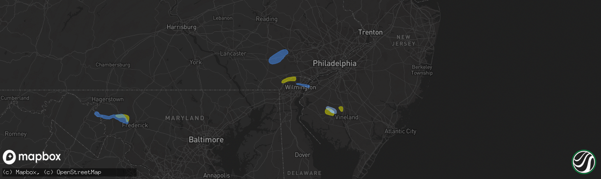
Wind
Hail
677
Estimated number of impacted properties by a 1.00" hail or larger0
Estimated number of impacted properties by a 1.75" hail or larger0
Estimated number of impacted properties by a 2.50" hail or largerStorm reports in Wilmington, DE
Wilmington, DE
| Date | Description |
|---|---|
| 08/07/20205:09 PM CDT | Trees and wires down at kennett pike and old kennett road. |
| 08/07/20204:57 PM CDT | Tree onto a house with people trapped in edgemoor gardens. Power lines down. Time estimated from radar. |
| 08/07/20204:55 PM CDT | Tree down onto power lines at wilmington washington street extension and hanover road in north wilmington. Time estimated from radar. |
| 08/07/20204:55 PM CDT | Several reports of trees down in wilmington. Time estimated from radar. |
| 08/07/20204:55 PM CDT | Trees down or snapped on north madison street between west 9th and west 10th streets in wilmington. Time estimated from radar. |
| 08/07/20204:55 PM CDT | Large tree uprooted and blocking school road in alapocas. Time estimated from radar. |
| 08/07/20204:52 PM CDT | Trees and power poles down in greenville. Time estimated from radar. |
| 08/07/20204:50 PM CDT | Numerous trees down or snapped with some onto homes. Time estimated from radar. |
| 08/07/20204:50 PM CDT | Trees and wires down along montchanin rd north of wilminton. Time estimated by radar. |
| 08/07/20204:50 PM CDT | Several trees down along centerville road in western greenville. Time estimated from radar and nearby reports. |
| 08/07/20204:50 PM CDT | Trees down in greenville. Time estimated by radar. |
| 08/07/20204:41 PM CDT | Significant straight-line wind damage occurred due to a severe rear-flank downdraft with winds up to 95 mph. This occurred from greenville to wilmington in northern del |
All States Impacted by Hail Map on August 7, 2020
All Cities Impacted by Hail Map on August 7, 2020
- Solway, MN
- Bagley, MN
- Shevlin, MN
- Naytahwaush, MN
- Cass Lake, MN
- Park Rapids, MN
- Laporte, MN
- Walker, MN
- Lake George, MN
- Ogema, MN
- Bena, MN
- Waubun, MN
- Grand Rapids, MN
- Goodland, MN
- Hibbing, MN
- Cohasset, MN
- Deer River, MN
- Bovey, MN
- Remer, MN
- Warba, MN
- Beulah, ND
- Zap, ND
- Hazen, ND
- Hebron, ND
- Glen Ullin, ND
- New Salem, ND
- Almont, ND
- Flasher, ND
- Carson, ND
- Raleigh, ND
- Upham, ND
- Kramer, ND
- Bottineau, ND
- Hockessin, DE
- Avondale, PA
- Landenberg, PA
- Kennett Square, PA
- Chadds Ford, PA
- Wilmington, DE
- Yorklyn, DE
- Elmer, NJ
- Bridgeton, NJ
- Vineland, NJ
- Newfield, NJ
- Ulen, MN
- Twin Valley, MN
- Nevis, MN
- Akeley, MN
- Hackensack, MN
- Backus, MN
- Osage, MN
- Mcadoo, PA
- Catawissa, PA
- Riverside, PA
- Hazleton, PA
- Sheppton, PA
- Zion Grove, PA
- Ringtown, PA
- Northumberland, PA
- Bloomsburg, PA
- Danville, PA
- Downingtown, PA
- Coatesville, PA
- Thorndale, PA
- Parkesburg, PA
- Glenmoore, PA
- Exton, PA
- Pedricktown, NJ
- Penns Grove, NJ
- Frederick, MD
- Middletown, MD
- Myersville, MD
- Statesboro, GA
- Buckhead, GA
- Greensboro, GA
- Deadwood, SD
- Lead, SD
- Keedysville, MD
- Boonsboro, MD
- Shepherdstown, WV
- Sharpsburg, MD
- Martinsburg, WV
- Williamsport, MD
- Karlstad, MN
- Kennedy, MN
- Ponsford, MN
- Palisade, MN
- Swatara, MN
- Greeley, KS
- Lane, KS
- Richmond, KS
- Franklin, WV
- Riverton, WV
- Circleville, WV
- Osteen, FL
- Geneva, FL
- Albany, MO
- Marcus Hook, PA
- Claymont, DE
- Swedesboro, NJ
- Webbers Falls, OK
- Vian, OK
- Porum, OK
- Neche, ND
- Walhalla, ND
- Gordon, WI
- Vassar, KS
- Quenemo, KS
- Pomona, KS
- Mahnomen, MN
- Dupree, SD
- Underwood, ND
- Stanton, ND
- Park Falls, WI
- Butternut, WI
- Cromwell, MN
- Mcgregor, MN
- Sturgeon Lake, MN
- Kettle River, MN
- Barnum, MN
- McGrath, MN
- Tamarack, MN
- Moose Lake, MN
- Milroy, PA
- Phillips, WI
- Madison, GA
- Keyes, OK
- Morton, TX
- Levelland, TX
- Ruso, ND
- Benedict, ND
- Clarkfield, MN
- Montevideo, MN
- Cochranville, PA
- Morristown, SD
- Keldron, SD
- Lemmon, SD
- Hill City, SD
- Aitkin, MN
- Pennington, MN
- Bemidji, MN
- Carrollton, MO
- Boyd, MN
- Minong, WI
- Williston, SC
- Lodgepole, SD
- Hatley, WI
- Lewisburg, PA
- Springfield, GA
- Waskish, MN
- Kelliher, MN
- Max, ND
- Oviedo, FL
- Enochs, TX
- Mifflinburg, PA
- Loganton, PA
- Amarillo, TX
- Muleshoe, TX
- Douglas, ND
- Rebersburg, PA
- Atglen, PA
- Ottawa, KS
- Amherst, TX
- Selfridge, ND
- Woodstown, NJ
- Franklinville, NJ
- Glassboro, NJ
- Mullica Hill, NJ
- Monroeville, NJ
- Pequot Lakes, MN
- Langdon, ND
- Emily, MN
- Pine River, MN
- Crosslake, MN
- Crosby, MN
- McFall, MO
- Watauga, SD
- McIntosh, SD
- Kingston, MO
- Hamilton, MO
- Rose, OK
- Peggs, OK
- Pembroke, NC
- Lumberton, NC
- Edgewood, MD
- Upper Falls, MD
- Joppa, MD
- Kingsville, MD
- Hopkins, SC
- Stigler, OK
- South Range, WI
- Lugoff, SC
- Berryton, KS
- Kenansville, FL
- Garrison, ND
- Mud Butte, SD
- Chester, PA
- Bathgate, ND
- Meadow, SD
- Hydes, MD
- Glen Arm, MD
- Eastover, SC
- Muskogee, OK
- Gore, OK
- Aston, PA
- Garnet Valley, PA
- Glen Mills, PA
- Bison, SD
- Rockland, DE
- Montchanin, DE
- Brookhaven, PA
- Hulbert, OK
- Tahlequah, OK
- Strandquist, MN
- Outing, MN
- Hayward, WI
- Tripoli, WI
- Maysville, MO
- King City, MO
- Norborne, MO
- Rapid City, SD
- Le Roy, KS
- Slater, MO
- New Bern, NC
- Blythewood, SC
- Elgin, SC
- Winter Garden, FL
- Aiken, SC
- Clewiston, FL
- Okeechobee, FL
- Drayton, ND
- Hallock, MN
- Danbury, WI
- Rozet, WY
- Tomahawk, WI
- Kennan, WI
- Malaga, NJ
- Bridgeport, NJ
- Toughkenamon, PA
- West Chester, PA
- Newark, DE
- Alloway, NJ
- West Grove, PA
- Clayton, NJ
- Calpine, CA
- Faison, NC
- Paola, KS
- Bennettsville, SC
- Burlington, KS
- Gridley, KS
- Dearing, GA
- Hephzibah, GA
- Blythe, GA
- Varnville, SC
- Estill, SC
- Saint Thomas, ND
- Bantry, ND
- Deering, ND
- Middle River, MN
- Elgin, ND
- Solon Springs, WI
- Quarryville, PA
- Christiana, PA
- Paradise, PA
- Granite Falls, MN
- Hanley Falls, MN
- Echo, MN
- Wood Lake, MN
- Havre De Grace, MD
- Aberdeen, MD
- Manheim, PA
- Bel Air, MD
- Churchville, MD
- Osawatomie, KS
- Tecumseh, KS
- Lecompton, KS
- Newton Grove, NC
- Williamsburg, KS
- Johnsonville, SC
- Mayesville, SC
- Register, GA
- Towner, ND
- Goodridge, MN
- Wright, MN
- McLaughlin, SD
- New Leipzig, ND
- Lawrence, KS
- Pattonsburg, MO
- Prentice, WI
- Rosendale, MO
- Savannah, MO
- Sierraville, CA
- Burlingame, KS
- Lyndon, KS
- Scranton, KS
- Newark, MD
- Snow Hill, MD
- Mount Olive, NC
- Coffeyville, KS
- Independence, KS
- Waverly, KS
- Hartsville, SC
- Interlachen, FL
- Galivants Ferry, SC
- Mullins, SC
- Nichols, SC
- Springfield, SC
- Salley, SC
- Gadsden, SC
- Cloquet, MN
- Kaycee, WY
- Waverly, MO
- Harveyville, KS
- Phoenix, MD
- Cameron, MO
- Kidder, MO
- Pelion, SC
- Winder, GA
- Statham, GA
- Maxton, NC
- McColl, SC
- Fort Myers, FL
- De Leon Springs, FL
- Gary, MN
- Wrenshall, MN
- Carlton, MN
- Bejou, MN
- Princeton, KS
- Keota, OK
- Greenville, NC
- Shelby, NC
- Manning, SC
- Columbia, SC
- Loris, SC
- Green Sea, SC
- East Palatka, FL
- Palatka, FL
- Elloree, SC
- Neeses, SC
- Lathrop, MO
- Fifty Lakes, MN
- Sandstone, MN
- Osborn, MO
- Parker, KS
- Zebulon, NC
- Wendell, NC
- Garnett, KS
- Rohrersville, MD
- Fairplay, MD
- Blackville, SC
- Red Springs, NC
- Shannon, NC
- Guyton, GA
- Crescent City, FL
- Deltona, FL
- Blackduck, MN
- Hitterdal, MN
- Gillette, WY
- Dundalk, MD
- Middle River, MD
- Edgerton, KS
- Benedict, KS
- Thayer, KS
- Altoona, KS
- Rockingham, NC
- Cameron, SC
- Orlando, FL
- Sundance, WY
- Sauk Centre, MN
- Jameson, MO
- Dawson, MN
- Chanute, KS
- Gainesville, FL
- Altha, FL
- Kinston, NC
- Bishopville, SC
- Swainsboro, GA
- Pierson, FL
- Bunnell, FL
- Osage City, KS
- Gap, PA
- Clio, SC
- Shields, ND
- Linton, ND
- Lexington, SC
- Orangeburg, SC
- Nottingham, MD
- Perry Hall, MD
- White Marsh, MD
- Fork, MD
- Fallston, MD
- Baldwin, MD
- Hartford, KS
- Bowman, SC
- Callahan, FL
- Helena, MO
- Union Star, MO
- Media, PA
- Pasadena, MD
- Thonotosassa, FL


