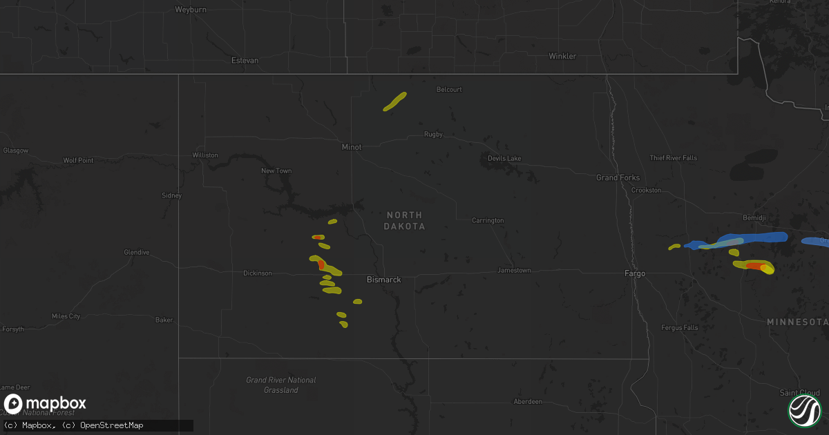
Hail Map in North Dakota on August 7, 2020
Get this storm
August 7 map
$229
one time, instant access
Download today. No call, no setup
Keep the $229
Bought the map and want the full workflow? Apply the entire $229 to a subscription within 7 days. None of it is wasted.
Every map, not just this one
This buys you this map. Subscription and you get every map we run, in the markets you choose from a few cities to whole states to nationwide. Plus real-time alerts the moment a storm fires.
Contact data
Name, contact info, occupancy, even credit band for addresses in the footprint. You go from where it hit to who to call.
Become the source they trust
Unlimited branding weather history reports on demand. You already have the documented answer ready for the property owner, and you are the one who showed up with it.
Property data and RoofTrace estimates
Pull up any address you have got, its value and the exact code rules for that jurisdiction, straight from One Click Code. Then RoofTrace estimates the squares, pitch, and roof value, priced the way you price.
Storm reports in North Dakota
North Dakota
| Date | Description |
|---|---|
| 08/07/20206:25 PM CDT | Relayed via broadcast media. |
| 08/07/20206:20 PM CDT | A local report indicates 1.25 inch wind near 1 SSW BEULAH |
| 08/07/20205:32 AM CDT | At 1032 PM CDT, a severe thunderstorm was located near Bottineau, moving northeast at 25 mph. HAZARD...60 mph wind gusts and quarter size hail. SOURCE...Radar indicated. IMPACT...Hail damage to vehicles is expected. Expect wind damage to roofs, siding, and trees. This severe thunderstorm will be near... Bottineau around 1045 PM CDT. Lake Metigoshe State Park around 1110 PM CDT.Other locations impacted by this severe thunderstorm include Gardenaand Carbury. |
| 08/07/20204:33 AM CDT | At 932 PM CDT, a severe thunderstorm was located over Upham, or 21 miles southwest of Bottineau, moving northeast at 25 mph. HAZARD...60 mph wind gusts and quarter size hail. SOURCE...Radar indicated. IMPACT...Hail damage to vehicles is expected. Expect wind damage to roofs, siding, and trees. This severe thunderstorm will be near... Willow City around 1015 PM CDT.Other locations impacted by this severe thunderstorm include Omemee,Gardena, Bantry and Kramer. |
| 08/07/20204:02 AM CDT | At 901 PM MDT, a severe thunderstorm was located 13 miles west of Shields, or 23 miles southeast of Elgin, moving southeast at 10 mph. HAZARD...60 mph wind gusts and half dollar size hail. SOURCE...Radar indicated. IMPACT...Hail damage to vehicles is expected. Expect wind damage to roofs, siding, and trees. This severe thunderstorm will remain over mainly rural areas of southeastern Grant County, including the following locations... St. Gertrude and Raleigh. |
| 08/07/20203:53 AM CDT | At 853 PM CDT, a severe thunderstorm was located 7 miles north of Flasher, or 22 miles southwest of Mandan, moving southeast at 15 mph. HAZARD...60 mph wind gusts and quarter size hail. SOURCE...Radar indicated. IMPACT...Hail damage to vehicles is expected. Expect wind damage to roofs, siding, and trees. This severe thunderstorm will remain over mainly rural areas of southeastern Morton County, including the following locations... Breien. |
| 08/07/20203:00 AM CDT | At 800 PM MDT, a severe thunderstorm was located 5 miles east of Carson, or 18 miles east of Elgin, moving southeast at 10 mph. HAZARD...60 mph wind gusts and quarter size hail. SOURCE...Radar indicated. IMPACT...Hail damage to vehicles is expected. Expect wind damage to roofs, siding, and trees. Locations impacted include... Carson, Lark, Raleigh, Leith, Heil and St. Gertrude. |
| 08/07/20202:45 AM CDT | At 744 PM CDT/644 PM MDT/, severe thunderstorms were located along a line extending from 4 miles north of New Salem to 5 miles southeast of Heart Butte Dam, moving east at 15 mph. HAZARD...60 mph wind gusts and half dollar size hail. SOURCE...Radar indicated. IMPACT...Hail damage to vehicles is expected. Expect wind damage to roofs, siding, and trees. Severe thunderstorms will be near... Almont and New Salem around 750 PM CDT.Other locations impacted by these severe thunderstorms include Lark,Sweet Briar Lake, Judson and Crown Butte Lake. |
| 08/07/20202:05 AM CDT | Delayed report. Time estimated based on radar. |
| 08/07/20201:55 AM CDT | At 654 PM CDT, severe thunderstorms were located along a line extending from 7 miles northwest of Hannover to near Glen Ullin, moving east at 30 mph. HAZARD...60 mph wind gusts and half dollar size hail. SOURCE...Radar indicated. IMPACT...Hail damage to vehicles is expected. Expect wind damage to roofs, siding, and trees. Severe thunderstorms will be near... Hannover around 700 PM CDT. Almont around 720 PM CDT. New Salem around 735 PM CDT.Other locations impacted by these severe thunderstorms include FortClark, Sweet Briar Lake, Judson and Nelson Lake. |
| 08/07/20201:16 AM CDT | At 616 PM CDT, a severe thunderstorm was located near Beulah, moving east at 15 mph. HAZARD...60 mph wind gusts and quarter size hail. SOURCE...Radar indicated. IMPACT...Hail damage to vehicles is expected. Expect wind damage to roofs, siding, and trees. This severe thunderstorm will be near... Beulah around 625 PM CDT. Hazen around 655 PM CDT. Stanton around 715 PM CDT. |
| 08/06/20209:05 PM CDT | Delayed report. Time estimated from radar. |
| 08/06/20208:55 PM CDT | Delayed report. Mostly small hail with a few quarters mixed in. Time estimated from radar. |
| 08/06/20208:50 PM CDT | A local report indicates 1.25 inch wind near CARSON |
| 08/06/20207:45 PM CDT | Relayed from broadcast media. |
| 08/06/20207:35 PM CDT | Hail was accompanied by strong winds that damaged wind breaks. Relayed via broadcast media. |
All States Impacted by Hail Map on August 7, 2020
Cities Impacted by Hail Map on August 7, 2020
- Solway, MN
- Bagley, MN
- Shevlin, MN
- Naytahwaush, MN
- Cass Lake, MN
- Park Rapids, MN
- Laporte, MN
- Walker, MN
- Lake George, MN
- Ogema, MN
- Bena, MN
- Waubun, MN
- Grand Rapids, MN
- Goodland, MN
- Hibbing, MN
- Cohasset, MN
- Deer River, MN
- Bovey, MN
- Remer, MN
- Warba, MN
- Beulah, ND
- Zap, ND
- Hazen, ND
- Hebron, ND
- Glen Ullin, ND
- New Salem, ND
- Almont, ND
- Flasher, ND
- Carson, ND
- Raleigh, ND
- Upham, ND
- Kramer, ND
- Bottineau, ND
- Hockessin, DE
- Avondale, PA
- Landenberg, PA
- Kennett Square, PA
- Chadds Ford, PA
- Wilmington, DE
- Yorklyn, DE
- Elmer, NJ
- Bridgeton, NJ
- Vineland, NJ
- Newfield, NJ
- Ulen, MN
- Twin Valley, MN
- Nevis, MN
- Akeley, MN
- Hackensack, MN
- Backus, MN
- Osage, MN
- Mcadoo, PA
- Catawissa, PA
- Riverside, PA
- Hazleton, PA
- Sheppton, PA
- Zion Grove, PA
- Ringtown, PA
- Northumberland, PA
- Bloomsburg, PA
- Danville, PA
- Downingtown, PA
- Coatesville, PA
- Thorndale, PA
- Parkesburg, PA
- Glenmoore, PA
- Exton, PA
- Pedricktown, NJ
- Penns Grove, NJ
- Frederick, MD
- Middletown, MD
- Myersville, MD
- Statesboro, GA
- Buckhead, GA
- Greensboro, GA
- Deadwood, SD
- Lead, SD
- Keedysville, MD
- Boonsboro, MD
- Shepherdstown, WV
- Sharpsburg, MD
- Martinsburg, WV
- Williamsport, MD
- Karlstad, MN
- Kennedy, MN
- Ponsford, MN
- Palisade, MN
- Swatara, MN
- Greeley, KS
- Lane, KS
- Richmond, KS
- Franklin, WV
- Riverton, WV
- Circleville, WV
- Osteen, FL
- Geneva, FL
- Albany, MO
- Marcus Hook, PA
- Claymont, DE
- Swedesboro, NJ
- Webbers Falls, OK
- Vian, OK
- Porum, OK
- Neche, ND
- Walhalla, ND
- Gordon, WI
- Vassar, KS
- Quenemo, KS
- Pomona, KS
- Mahnomen, MN
- Dupree, SD
- Underwood, ND
- Stanton, ND
- Park Falls, WI
- Butternut, WI
- Cromwell, MN
- Mcgregor, MN
- Sturgeon Lake, MN
- Kettle River, MN
- Barnum, MN
- McGrath, MN
- Tamarack, MN
- Moose Lake, MN
- Milroy, PA
- Phillips, WI
- Madison, GA
- Keyes, OK
- Morton, TX
- Levelland, TX
- Ruso, ND
- Benedict, ND
- Clarkfield, MN
- Montevideo, MN
- Cochranville, PA
- Morristown, SD
- Keldron, SD
- Lemmon, SD
- Hill City, SD
- Aitkin, MN
- Pennington, MN
- Bemidji, MN
- Carrollton, MO
- Boyd, MN
- Minong, WI
- Williston, SC
- Lodgepole, SD
- Hatley, WI
- Lewisburg, PA
- Springfield, GA
- Waskish, MN
- Kelliher, MN
- Max, ND
- Oviedo, FL
- Enochs, TX
- Mifflinburg, PA
- Loganton, PA
- Amarillo, TX
- Muleshoe, TX
- Douglas, ND
- Rebersburg, PA
- Atglen, PA
- Ottawa, KS
- Amherst, TX
- Selfridge, ND
- Woodstown, NJ
- Franklinville, NJ
- Glassboro, NJ
- Mullica Hill, NJ
- Monroeville, NJ
- Pequot Lakes, MN
- Langdon, ND
- Emily, MN
- Pine River, MN
- Crosslake, MN
- Crosby, MN
- McFall, MO
- Watauga, SD
- McIntosh, SD
- Kingston, MO
- Hamilton, MO
- Rose, OK
- Peggs, OK
- Pembroke, NC
- Lumberton, NC
- Edgewood, MD
- Upper Falls, MD
- Joppa, MD
- Kingsville, MD
- Hopkins, SC
- Stigler, OK
- South Range, WI
- Lugoff, SC
- Berryton, KS
- Kenansville, FL
- Garrison, ND
- Mud Butte, SD
- Chester, PA
- Bathgate, ND
- Meadow, SD
- Hydes, MD
- Glen Arm, MD
- Eastover, SC
- Muskogee, OK
- Gore, OK
- Aston, PA
- Garnet Valley, PA
- Glen Mills, PA
- Bison, SD
- Rockland, DE
- Montchanin, DE
- Brookhaven, PA
- Hulbert, OK
- Tahlequah, OK
- Strandquist, MN
- Outing, MN
- Hayward, WI
- Tripoli, WI
- Maysville, MO
- King City, MO
- Norborne, MO
- Rapid City, SD
- Le Roy, KS
- Slater, MO
- New Bern, NC
- Blythewood, SC
- Elgin, SC
- Winter Garden, FL
- Aiken, SC
- Clewiston, FL
- Okeechobee, FL
- Drayton, ND
- Hallock, MN
- Danbury, WI
- Rozet, WY
- Tomahawk, WI
- Kennan, WI
- Malaga, NJ
- Bridgeport, NJ
- Toughkenamon, PA
- West Chester, PA
- Newark, DE
- Alloway, NJ
- West Grove, PA
- Clayton, NJ
- Calpine, CA
- Faison, NC
- Paola, KS
- Bennettsville, SC
- Burlington, KS
- Gridley, KS
- Dearing, GA
- Hephzibah, GA
- Blythe, GA
- Varnville, SC
- Estill, SC
- Saint Thomas, ND
- Bantry, ND
- Deering, ND
- Middle River, MN
- Elgin, ND
- Solon Springs, WI
- Quarryville, PA
- Christiana, PA
- Paradise, PA
- Granite Falls, MN
- Hanley Falls, MN
- Echo, MN
- Wood Lake, MN
- Havre De Grace, MD
- Aberdeen, MD
- Manheim, PA
- Bel Air, MD
- Churchville, MD
- Osawatomie, KS
- Tecumseh, KS
- Lecompton, KS
- Newton Grove, NC
- Williamsburg, KS
- Johnsonville, SC
- Mayesville, SC
- Register, GA
- Towner, ND
- Goodridge, MN
- Wright, MN
- McLaughlin, SD
- New Leipzig, ND
- Lawrence, KS
- Pattonsburg, MO
- Prentice, WI
- Rosendale, MO
- Savannah, MO
- Sierraville, CA
- Burlingame, KS
- Lyndon, KS
- Scranton, KS
- Newark, MD
- Snow Hill, MD
- Mount Olive, NC
- Coffeyville, KS
- Independence, KS
- Waverly, KS
- Hartsville, SC
- Interlachen, FL
- Galivants Ferry, SC
- Mullins, SC
- Nichols, SC
- Springfield, SC
- Salley, SC
- Gadsden, SC
- Cloquet, MN
- Kaycee, WY
- Waverly, MO
- Harveyville, KS
- Phoenix, MD
- Cameron, MO
- Kidder, MO
- Pelion, SC
- Winder, GA
- Statham, GA
- Maxton, NC
- McColl, SC
- Fort Myers, FL
- De Leon Springs, FL
- Gary, MN
- Wrenshall, MN
- Carlton, MN
- Bejou, MN
- Princeton, KS
- Keota, OK
- Greenville, NC
- Shelby, NC
- Manning, SC
- Columbia, SC
- Loris, SC
- Green Sea, SC
- East Palatka, FL
- Palatka, FL
- Elloree, SC
- Neeses, SC
- Lathrop, MO
- Fifty Lakes, MN
- Sandstone, MN
- Osborn, MO
- Parker, KS
- Zebulon, NC
- Wendell, NC
- Garnett, KS
- Rohrersville, MD
- Fairplay, MD
- Blackville, SC
- Red Springs, NC
- Shannon, NC
- Guyton, GA
- Crescent City, FL
- Deltona, FL
- Blackduck, MN
- Hitterdal, MN
- Gillette, WY
- Dundalk, MD
- Middle River, MD
- Edgerton, KS
- Benedict, KS
- Thayer, KS
- Altoona, KS
- Rockingham, NC
- Cameron, SC
- Orlando, FL
- Sundance, WY
- Sauk Centre, MN
- Jameson, MO
- Dawson, MN
- Chanute, KS
- Gainesville, FL
- Altha, FL
- Kinston, NC
- Bishopville, SC
- Swainsboro, GA
- Pierson, FL
- Bunnell, FL
- Osage City, KS
- Gap, PA
- Clio, SC
- Shields, ND
- Linton, ND
- Lexington, SC
- Orangeburg, SC
- Nottingham, MD
- Perry Hall, MD
- White Marsh, MD
- Fork, MD
- Fallston, MD
- Baldwin, MD
- Hartford, KS
- Bowman, SC
- Callahan, FL
- Helena, MO
- Union Star, MO
- Media, PA
- Pasadena, MD
- Thonotosassa, FL


