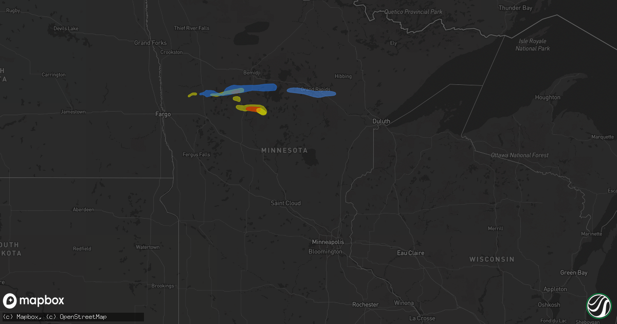
Hail Map in Minnesota on August 7, 2020
Get this storm
August 7 map
$229
one time, instant access
Download today. No call, no setup
Keep the $229
Bought the map and want the full workflow? Apply the entire $229 to a subscription within 7 days. None of it is wasted.
Every map, not just this one
This buys you this map. Subscription and you get every map we run, in the markets you choose from a few cities to whole states to nationwide. Plus real-time alerts the moment a storm fires.
Contact data
Name, contact info, occupancy, even credit band for addresses in the footprint. You go from where it hit to who to call.
Become the source they trust
Unlimited branding weather history reports on demand. You already have the documented answer ready for the property owner, and you are the one who showed up with it.
Property data and RoofTrace estimates
Pull up any address you have got, its value and the exact code rules for that jurisdiction, straight from One Click Code. Then RoofTrace estimates the squares, pitch, and roof value, priced the way you price.
Storm reports in Minnesota
Minnesota
| Date | Description |
|---|---|
| 08/07/20206:30 PM CDT | Trees down hwy 71 and glidden rd |
| 08/07/20206:25 PM CDT | A few poplar trees snapped around lake minnie. Report posted via social media. Time estimated based on radar. |
| 08/07/20205:50 PM CDT | Near the main lodge. |
| 08/07/20205:50 PM CDT | A local report indicates 1.00 inch wind near LAKE ITASCA |
| 08/07/20205:27 PM CDT | A few quarter to half dollar sized hail fell along hwy 113. Time estimated based on radar. |
| 08/07/20205:05 PM CDT | A couple of trees blown down along cr144. Time estimated based on radar. |
| 08/07/20204:55 PM CDT | A local report indicates 1.00 inch wind near WAUBUN |
| 08/07/20204:25 PM CDT | Lots of golf ball and larger sized hail. |
| 08/07/20204:21 PM CDT | Large hail and very heavy rain. |
| 08/07/20204:29 AM CDT | At 929 PM CDT, severe thunderstorms were located along a line extending from Pengilly, to 6 miles west of Warba, to 6 miles northwest of Hill City, moving east at 35 mph. HAZARD...60 mph wind gusts. SOURCE...Radar indicated. IMPACT...Expect damage to roofs, siding, and trees. Locations impacted include... Hibbing, Grand Rapids, Cohasset, Coleraine, Keewatin, Nashwauk, Cherry, Swan River, Hill City, Taconite, Warba, Toivola, Gunn, Pengilly, Jacobson, Blackberry, Bovey, Marble, La Prairie, and Hart Lake. |
| 08/07/20204:16 AM CDT | At 916 PM CDT, a severe thunderstorm was located over Backus, or 18 miles south of Walker, moving east at 20 mph. HAZARD...60 mph wind gusts and half dollar size hail. SOURCE...Radar indicated. IMPACT...Hail damage to vehicles is expected. Expect wind damage to roofs, siding, and trees. Locations impacted include... Breezy Point, Crosslake, Pine River, Fifty Lakes, Hackensack, Backus, Oshawa, Chickamaw Beach, Manhattan Beach, Lower Hay Lake, Pheasant Lake, Lake Ada, Swanburg, Lower Whitefish Lake, Big Trout Lake, Pontoria, and Big Portage Lake. |
| 08/07/20204:00 AM CDT | At 900 PM CDT, severe thunderstorms were located along a line extending from Chamberlain to near Dorset, moving east at 10 mph. HAZARD...60 mph wind gusts and quarter size hail. SOURCE...Radar indicated. IMPACT...Hail damage to vehicles is expected. Expect wind damage to roofs, siding, and trees. Severe thunderstorms will be near... Chamberlain and Badoura around 905 PM CDT. Nevis around 950 PM CDT. Akeley around 1000 PM CDT. |
| 08/07/20203:47 AM CDT | At 847 PM CDT, a severe thunderstorm was located over Chamberlain, or 40 miles south of Bemidji, moving east at 15 mph. HAZARD...Ping pong ball size hail and 60 mph wind gusts. SOURCE...Radar indicated. IMPACT...People and animals outdoors will be injured. Expect hail damage to roofs, siding, windows, and vehicles. Expect wind damage to roofs, siding, and trees. This severe thunderstorm will remain over mainly rural areas of southeastern Hubbard County. |
| 08/07/20203:28 AM CDT | At 827 PM CDT, a severe thunderstorm was located over Nevis, or 15 miles southwest of Walker, moving east at 20 mph. HAZARD...Ping pong ball size hail and 60 mph wind gusts. SOURCE...Radar indicated. IMPACT...People and animals outdoors will be injured. Expect hail damage to roofs, siding, windows, and vehicles. Expect wind damage to roofs, siding, and trees. Locations impacted include... Hackensack, Backus, and Ten Mile Lake. |
| 08/07/20201:43 AM CDT | At 643 PM CDT, a severe thunderstorm was located over Laporte, or 11 miles northwest of Walker, moving east at 25 mph. HAZARD...60 mph wind gusts and penny size hail. SOURCE...Radar indicated. IMPACT...Expect damage to roofs, siding, and trees. Locations impacted include... Walker, Federal Dam, Leech Lake, Cass Lake, Wilkinson, Whipholt, Brevik, and Portage Lake. |
| 08/07/20201:30 AM CDT | Multiple 8 inch diameter trees were down along with blown over corn stalks. |
| 08/07/20201:18 AM CDT | At 618 PM CDT, severe thunderstorms were located along a line extending from near Wilton to Lake George, moving east at 30 mph. HAZARD...60 mph wind gusts and nickel size hail. SOURCE...Radar indicated. IMPACT...Expect damage to roofs, siding, and trees. Severe thunderstorms will be near... Wilton and Camp Wilderness around 620 PM CDT. Bemidji around 625 PM CDT. Kabekona around 630 PM CDT. Lake Bemidji State Park and Lavinia around 635 PM CDT. Guthrie around 640 PM CDT.Other locations impacted by these severe thunderstorms include CampThunderbird East and Camp Thunderbird West. |
| 08/07/20201:10 AM CDT | A few trees were down by the moose lake golf club on sand lake. Time estimated by radar. |
| 08/07/20201:02 AM CDT | Two 6 to 8 inch diameter trees down. |
| 08/07/202012:30 AM CDT | At 529 PM CDT, severe thunderstorms were located along a line extending from near Rice Lake to near Bad Medicine Lake, moving east at 35 mph. HAZARD...60 mph wind gusts and quarter size hail. SOURCE...Radar indicated. IMPACT...Hail damage to vehicles is expected. Expect wind damage to roofs, siding, and trees. Severe thunderstorms will be near... Zerkel around 535 PM CDT. Upper Rice Lake around 545 PM CDT. Alida, Two Inlets and Itasca State Park around 550 PM CDT. Becida around 600 PM CDT. Lake George and Emmaville around 610 PM CDT.Other locations impacted by these severe thunderstorms include CampThunderbird East, Camp Thunderbird West and Many Point Scout Camp. |
| 08/06/202011:57 PM CDT | At 456 PM CDT, a severe thunderstorm was located near White Earth, or 23 miles north of Detroit Lakes, moving east at 20 mph. HAZARD...60 mph wind gusts and quarter size hail. SOURCE...Radar indicated. IMPACT...Hail damage to vehicles is expected. Expect wind damage to roofs, siding, and trees. This severe thunderstorm will be near... Tulaby Lake around 520 PM CDT. Many Point Lake around 530 PM CDT. Long Lost Lake around 545 PM CDT. Bad Medicine Lake around 550 PM CDT.Other locations impacted by this severe thunderstorm include ManyPoint Scout Camp. |
| 08/06/202011:17 PM CDT | At 417 PM CDT, a severe thunderstorm was located near Syre, or 28 miles northwest of Detroit Lakes, moving northeast at 20 mph. HAZARD...60 mph wind gusts and quarter size hail. SOURCE...Radar indicated. IMPACT...Hail damage to vehicles is expected. Expect wind damage to roofs, siding, and trees. This severe thunderstorm will be near... Flom around 430 PM CDT. Faith around 445 PM CDT. Waubun around 455 PM CDT. Mahnomen around 505 PM CDT. |
| 08/06/202011:05 PM CDT | A local report indicates 1.00 inch wind near 5 S SWANBURG |
| 08/06/202010:57 PM CDT | A few small trees down along shoreline of big sandy lake. Time estimated off radar. |
| 08/06/202010:35 PM CDT | Tree down across highway 1. |
| 08/06/202010:00 PM CDT | Reported at chisholm... Mn lake street. Picture of medium sized tree down next to apartment. |
| 08/06/20209:50 PM CDT | Quarter to half dollar ized hail in very heavy rain. |
| 08/06/20209:20 PM CDT | Large spiked hailstones near lower ojibway lake. Photo and report posated via social media. Time estimated based on radar. |
| 08/06/20208:50 PM CDT | A few trees blown down across southeast white oak township. |
| 08/06/20208:10 PM CDT | Near lake belle taine |
| 08/06/20208:05 PM CDT | A tornado likely wrapped in heavy rain and down burst winds tracked for roughly 6 miles to around 3 ese of nevis by 825 pm cdt. It crossed portions of shallow lake... T |
| 08/06/20207:50 PM CDT | A local report indicates 1.50 inch wind near DORSET |
| 08/06/20207:45 PM CDT | Numerous trees blown down across southern emma township from potatoe lake into big sand lake. |
| 08/06/20207:30 PM CDT | Video and spotter reports of sustained wall cloud with multiple funnels and multiple brief touchdowns over few minute period west of fishhook lake and near hwy 71. Spot |
| 08/06/20207:30 PM CDT | Possible tornado touchdown west side of fishhook lake near hwy 71. Video and numerous pictures would indicate touchdown... But in all pictures the very bottom is obscur |
| 08/06/20207:00 PM CDT | Trees blocking power dam road and connor road |
All States Impacted by Hail Map on August 7, 2020
Cities Impacted by Hail Map on August 7, 2020
- Solway, MN
- Bagley, MN
- Shevlin, MN
- Naytahwaush, MN
- Cass Lake, MN
- Park Rapids, MN
- Laporte, MN
- Walker, MN
- Lake George, MN
- Ogema, MN
- Bena, MN
- Waubun, MN
- Grand Rapids, MN
- Goodland, MN
- Hibbing, MN
- Cohasset, MN
- Deer River, MN
- Bovey, MN
- Remer, MN
- Warba, MN
- Beulah, ND
- Zap, ND
- Hazen, ND
- Hebron, ND
- Glen Ullin, ND
- New Salem, ND
- Almont, ND
- Flasher, ND
- Carson, ND
- Raleigh, ND
- Upham, ND
- Kramer, ND
- Bottineau, ND
- Hockessin, DE
- Avondale, PA
- Landenberg, PA
- Kennett Square, PA
- Chadds Ford, PA
- Wilmington, DE
- Yorklyn, DE
- Elmer, NJ
- Bridgeton, NJ
- Vineland, NJ
- Newfield, NJ
- Ulen, MN
- Twin Valley, MN
- Nevis, MN
- Akeley, MN
- Hackensack, MN
- Backus, MN
- Osage, MN
- Mcadoo, PA
- Catawissa, PA
- Riverside, PA
- Hazleton, PA
- Sheppton, PA
- Zion Grove, PA
- Ringtown, PA
- Northumberland, PA
- Bloomsburg, PA
- Danville, PA
- Downingtown, PA
- Coatesville, PA
- Thorndale, PA
- Parkesburg, PA
- Glenmoore, PA
- Exton, PA
- Pedricktown, NJ
- Penns Grove, NJ
- Frederick, MD
- Middletown, MD
- Myersville, MD
- Statesboro, GA
- Buckhead, GA
- Greensboro, GA
- Deadwood, SD
- Lead, SD
- Keedysville, MD
- Boonsboro, MD
- Shepherdstown, WV
- Sharpsburg, MD
- Martinsburg, WV
- Williamsport, MD
- Karlstad, MN
- Kennedy, MN
- Ponsford, MN
- Palisade, MN
- Swatara, MN
- Greeley, KS
- Lane, KS
- Richmond, KS
- Franklin, WV
- Riverton, WV
- Circleville, WV
- Osteen, FL
- Geneva, FL
- Albany, MO
- Marcus Hook, PA
- Claymont, DE
- Swedesboro, NJ
- Webbers Falls, OK
- Vian, OK
- Porum, OK
- Neche, ND
- Walhalla, ND
- Gordon, WI
- Vassar, KS
- Quenemo, KS
- Pomona, KS
- Mahnomen, MN
- Dupree, SD
- Underwood, ND
- Stanton, ND
- Park Falls, WI
- Butternut, WI
- Cromwell, MN
- Mcgregor, MN
- Sturgeon Lake, MN
- Kettle River, MN
- Barnum, MN
- McGrath, MN
- Tamarack, MN
- Moose Lake, MN
- Milroy, PA
- Phillips, WI
- Madison, GA
- Keyes, OK
- Morton, TX
- Levelland, TX
- Ruso, ND
- Benedict, ND
- Clarkfield, MN
- Montevideo, MN
- Cochranville, PA
- Morristown, SD
- Keldron, SD
- Lemmon, SD
- Hill City, SD
- Aitkin, MN
- Pennington, MN
- Bemidji, MN
- Carrollton, MO
- Boyd, MN
- Minong, WI
- Williston, SC
- Lodgepole, SD
- Hatley, WI
- Lewisburg, PA
- Springfield, GA
- Waskish, MN
- Kelliher, MN
- Max, ND
- Oviedo, FL
- Enochs, TX
- Mifflinburg, PA
- Loganton, PA
- Amarillo, TX
- Muleshoe, TX
- Douglas, ND
- Rebersburg, PA
- Atglen, PA
- Ottawa, KS
- Amherst, TX
- Selfridge, ND
- Woodstown, NJ
- Franklinville, NJ
- Glassboro, NJ
- Mullica Hill, NJ
- Monroeville, NJ
- Pequot Lakes, MN
- Langdon, ND
- Emily, MN
- Pine River, MN
- Crosslake, MN
- Crosby, MN
- McFall, MO
- Watauga, SD
- McIntosh, SD
- Kingston, MO
- Hamilton, MO
- Rose, OK
- Peggs, OK
- Pembroke, NC
- Lumberton, NC
- Edgewood, MD
- Upper Falls, MD
- Joppa, MD
- Kingsville, MD
- Hopkins, SC
- Stigler, OK
- South Range, WI
- Lugoff, SC
- Berryton, KS
- Kenansville, FL
- Garrison, ND
- Mud Butte, SD
- Chester, PA
- Bathgate, ND
- Meadow, SD
- Hydes, MD
- Glen Arm, MD
- Eastover, SC
- Muskogee, OK
- Gore, OK
- Aston, PA
- Garnet Valley, PA
- Glen Mills, PA
- Bison, SD
- Rockland, DE
- Montchanin, DE
- Brookhaven, PA
- Hulbert, OK
- Tahlequah, OK
- Strandquist, MN
- Outing, MN
- Hayward, WI
- Tripoli, WI
- Maysville, MO
- King City, MO
- Norborne, MO
- Rapid City, SD
- Le Roy, KS
- Slater, MO
- New Bern, NC
- Blythewood, SC
- Elgin, SC
- Winter Garden, FL
- Aiken, SC
- Clewiston, FL
- Okeechobee, FL
- Drayton, ND
- Hallock, MN
- Danbury, WI
- Rozet, WY
- Tomahawk, WI
- Kennan, WI
- Malaga, NJ
- Bridgeport, NJ
- Toughkenamon, PA
- West Chester, PA
- Newark, DE
- Alloway, NJ
- West Grove, PA
- Clayton, NJ
- Calpine, CA
- Faison, NC
- Paola, KS
- Bennettsville, SC
- Burlington, KS
- Gridley, KS
- Dearing, GA
- Hephzibah, GA
- Blythe, GA
- Varnville, SC
- Estill, SC
- Saint Thomas, ND
- Bantry, ND
- Deering, ND
- Middle River, MN
- Elgin, ND
- Solon Springs, WI
- Quarryville, PA
- Christiana, PA
- Paradise, PA
- Granite Falls, MN
- Hanley Falls, MN
- Echo, MN
- Wood Lake, MN
- Havre De Grace, MD
- Aberdeen, MD
- Manheim, PA
- Bel Air, MD
- Churchville, MD
- Osawatomie, KS
- Tecumseh, KS
- Lecompton, KS
- Newton Grove, NC
- Williamsburg, KS
- Johnsonville, SC
- Mayesville, SC
- Register, GA
- Towner, ND
- Goodridge, MN
- Wright, MN
- McLaughlin, SD
- New Leipzig, ND
- Lawrence, KS
- Pattonsburg, MO
- Prentice, WI
- Rosendale, MO
- Savannah, MO
- Sierraville, CA
- Burlingame, KS
- Lyndon, KS
- Scranton, KS
- Newark, MD
- Snow Hill, MD
- Mount Olive, NC
- Coffeyville, KS
- Independence, KS
- Waverly, KS
- Hartsville, SC
- Interlachen, FL
- Galivants Ferry, SC
- Mullins, SC
- Nichols, SC
- Springfield, SC
- Salley, SC
- Gadsden, SC
- Cloquet, MN
- Kaycee, WY
- Waverly, MO
- Harveyville, KS
- Phoenix, MD
- Cameron, MO
- Kidder, MO
- Pelion, SC
- Winder, GA
- Statham, GA
- Maxton, NC
- McColl, SC
- Fort Myers, FL
- De Leon Springs, FL
- Gary, MN
- Wrenshall, MN
- Carlton, MN
- Bejou, MN
- Princeton, KS
- Keota, OK
- Greenville, NC
- Shelby, NC
- Manning, SC
- Columbia, SC
- Loris, SC
- Green Sea, SC
- East Palatka, FL
- Palatka, FL
- Elloree, SC
- Neeses, SC
- Lathrop, MO
- Fifty Lakes, MN
- Sandstone, MN
- Osborn, MO
- Parker, KS
- Zebulon, NC
- Wendell, NC
- Garnett, KS
- Rohrersville, MD
- Fairplay, MD
- Blackville, SC
- Red Springs, NC
- Shannon, NC
- Guyton, GA
- Crescent City, FL
- Deltona, FL
- Blackduck, MN
- Hitterdal, MN
- Gillette, WY
- Dundalk, MD
- Middle River, MD
- Edgerton, KS
- Benedict, KS
- Thayer, KS
- Altoona, KS
- Rockingham, NC
- Cameron, SC
- Orlando, FL
- Sundance, WY
- Sauk Centre, MN
- Jameson, MO
- Dawson, MN
- Chanute, KS
- Gainesville, FL
- Altha, FL
- Kinston, NC
- Bishopville, SC
- Swainsboro, GA
- Pierson, FL
- Bunnell, FL
- Osage City, KS
- Gap, PA
- Clio, SC
- Shields, ND
- Linton, ND
- Lexington, SC
- Orangeburg, SC
- Nottingham, MD
- Perry Hall, MD
- White Marsh, MD
- Fork, MD
- Fallston, MD
- Baldwin, MD
- Hartford, KS
- Bowman, SC
- Callahan, FL
- Helena, MO
- Union Star, MO
- Media, PA
- Pasadena, MD
- Thonotosassa, FL


