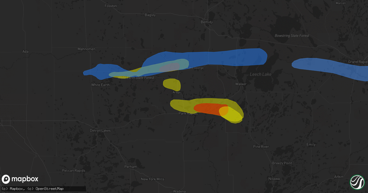
Hail Map in Park Rapids, MN on August 7, 2020
Get this storm
August 7 map
$229
one time, instant access
Download today. No call, no setup
Keep the $229
Bought the map and want the full workflow? Apply the entire $229 to a subscription within 7 days. None of it is wasted.
Every map, not just this one
This buys you this map. Subscription and you get every map we run, in the markets you choose from a few cities to whole states to nationwide. Plus real-time alerts the moment a storm fires.
Contact data
Name, contact info, occupancy, even credit band for addresses in the footprint. You go from where it hit to who to call.
Become the source they trust
Unlimited branding weather history reports on demand. You already have the documented answer ready for the property owner, and you are the one who showed up with it.
Property data and RoofTrace estimates
Pull up any address you have got, its value and the exact code rules for that jurisdiction, straight from One Click Code. Then RoofTrace estimates the squares, pitch, and roof value, priced the way you price.
Storm reports in Park Rapids, MN
Park Rapids, MN
| Date | Description |
|---|---|
| 08/07/20205:50 PM CDT | A local report indicates 1.00 inch wind near LAKE ITASCA |
| 08/07/20205:50 PM CDT | Near the main lodge. |
| 08/07/20201:02 AM CDT | Two 6 to 8 inch diameter trees down. |
| 08/06/20207:50 PM CDT | A local report indicates 1.50 inch wind near DORSET |
| 08/06/20207:45 PM CDT | Numerous trees blown down across southern emma township from potatoe lake into big sand lake. |
| 08/06/20207:30 PM CDT | Possible tornado touchdown west side of fishhook lake near hwy 71. Video and numerous pictures would indicate touchdown... But in all pictures the very bottom is obscur |
| 08/06/20207:30 PM CDT | Video and spotter reports of sustained wall cloud with multiple funnels and multiple brief touchdowns over few minute period west of fishhook lake and near hwy 71. Spot |
All States Impacted by Hail Map on August 7, 2020
All Cities Impacted by Hail Map on August 7, 2020
- Solway, MN
- Bagley, MN
- Shevlin, MN
- Naytahwaush, MN
- Cass Lake, MN
- Park Rapids, MN
- Laporte, MN
- Walker, MN
- Lake George, MN
- Ogema, MN
- Bena, MN
- Waubun, MN
- Grand Rapids, MN
- Goodland, MN
- Hibbing, MN
- Cohasset, MN
- Deer River, MN
- Bovey, MN
- Remer, MN
- Warba, MN
- Beulah, ND
- Zap, ND
- Hazen, ND
- Hebron, ND
- Glen Ullin, ND
- New Salem, ND
- Almont, ND
- Flasher, ND
- Carson, ND
- Raleigh, ND
- Upham, ND
- Kramer, ND
- Bottineau, ND
- Hockessin, DE
- Avondale, PA
- Landenberg, PA
- Kennett Square, PA
- Chadds Ford, PA
- Wilmington, DE
- Yorklyn, DE
- Elmer, NJ
- Bridgeton, NJ
- Vineland, NJ
- Newfield, NJ
- Ulen, MN
- Twin Valley, MN
- Nevis, MN
- Akeley, MN
- Hackensack, MN
- Backus, MN
- Osage, MN
- Mcadoo, PA
- Catawissa, PA
- Riverside, PA
- Hazleton, PA
- Sheppton, PA
- Zion Grove, PA
- Ringtown, PA
- Northumberland, PA
- Bloomsburg, PA
- Danville, PA
- Downingtown, PA
- Coatesville, PA
- Thorndale, PA
- Parkesburg, PA
- Glenmoore, PA
- Exton, PA
- Pedricktown, NJ
- Penns Grove, NJ
- Frederick, MD
- Middletown, MD
- Myersville, MD
- Statesboro, GA
- Buckhead, GA
- Greensboro, GA
- Deadwood, SD
- Lead, SD
- Keedysville, MD
- Boonsboro, MD
- Shepherdstown, WV
- Sharpsburg, MD
- Martinsburg, WV
- Williamsport, MD
- Karlstad, MN
- Kennedy, MN
- Ponsford, MN
- Palisade, MN
- Swatara, MN
- Greeley, KS
- Lane, KS
- Richmond, KS
- Franklin, WV
- Riverton, WV
- Circleville, WV
- Osteen, FL
- Geneva, FL
- Albany, MO
- Marcus Hook, PA
- Claymont, DE
- Swedesboro, NJ
- Webbers Falls, OK
- Vian, OK
- Porum, OK
- Neche, ND
- Walhalla, ND
- Gordon, WI
- Vassar, KS
- Quenemo, KS
- Pomona, KS
- Mahnomen, MN
- Dupree, SD
- Underwood, ND
- Stanton, ND
- Park Falls, WI
- Butternut, WI
- Cromwell, MN
- Mcgregor, MN
- Sturgeon Lake, MN
- Kettle River, MN
- Barnum, MN
- McGrath, MN
- Tamarack, MN
- Moose Lake, MN
- Milroy, PA
- Phillips, WI
- Madison, GA
- Keyes, OK
- Morton, TX
- Levelland, TX
- Ruso, ND
- Benedict, ND
- Clarkfield, MN
- Montevideo, MN
- Cochranville, PA
- Morristown, SD
- Keldron, SD
- Lemmon, SD
- Hill City, SD
- Aitkin, MN
- Pennington, MN
- Bemidji, MN
- Carrollton, MO
- Boyd, MN
- Minong, WI
- Williston, SC
- Lodgepole, SD
- Hatley, WI
- Lewisburg, PA
- Springfield, GA
- Waskish, MN
- Kelliher, MN
- Max, ND
- Oviedo, FL
- Enochs, TX
- Mifflinburg, PA
- Loganton, PA
- Amarillo, TX
- Muleshoe, TX
- Douglas, ND
- Rebersburg, PA
- Atglen, PA
- Ottawa, KS
- Amherst, TX
- Selfridge, ND
- Woodstown, NJ
- Franklinville, NJ
- Glassboro, NJ
- Mullica Hill, NJ
- Monroeville, NJ
- Pequot Lakes, MN
- Langdon, ND
- Emily, MN
- Pine River, MN
- Crosslake, MN
- Crosby, MN
- McFall, MO
- Watauga, SD
- McIntosh, SD
- Kingston, MO
- Hamilton, MO
- Rose, OK
- Peggs, OK
- Pembroke, NC
- Lumberton, NC
- Edgewood, MD
- Upper Falls, MD
- Joppa, MD
- Kingsville, MD
- Hopkins, SC
- Stigler, OK
- South Range, WI
- Lugoff, SC
- Berryton, KS
- Kenansville, FL
- Garrison, ND
- Mud Butte, SD
- Chester, PA
- Bathgate, ND
- Meadow, SD
- Hydes, MD
- Glen Arm, MD
- Eastover, SC
- Muskogee, OK
- Gore, OK
- Aston, PA
- Garnet Valley, PA
- Glen Mills, PA
- Bison, SD
- Rockland, DE
- Montchanin, DE
- Brookhaven, PA
- Hulbert, OK
- Tahlequah, OK
- Strandquist, MN
- Outing, MN
- Hayward, WI
- Tripoli, WI
- Maysville, MO
- King City, MO
- Norborne, MO
- Rapid City, SD
- Le Roy, KS
- Slater, MO
- New Bern, NC
- Blythewood, SC
- Elgin, SC
- Winter Garden, FL
- Aiken, SC
- Clewiston, FL
- Okeechobee, FL
- Drayton, ND
- Hallock, MN
- Danbury, WI
- Rozet, WY
- Tomahawk, WI
- Kennan, WI
- Malaga, NJ
- Bridgeport, NJ
- Toughkenamon, PA
- West Chester, PA
- Newark, DE
- Alloway, NJ
- West Grove, PA
- Clayton, NJ
- Calpine, CA
- Faison, NC
- Paola, KS
- Bennettsville, SC
- Burlington, KS
- Gridley, KS
- Dearing, GA
- Hephzibah, GA
- Blythe, GA
- Varnville, SC
- Estill, SC
- Saint Thomas, ND
- Bantry, ND
- Deering, ND
- Middle River, MN
- Elgin, ND
- Solon Springs, WI
- Quarryville, PA
- Christiana, PA
- Paradise, PA
- Granite Falls, MN
- Hanley Falls, MN
- Echo, MN
- Wood Lake, MN
- Havre De Grace, MD
- Aberdeen, MD
- Manheim, PA
- Bel Air, MD
- Churchville, MD
- Osawatomie, KS
- Tecumseh, KS
- Lecompton, KS
- Newton Grove, NC
- Williamsburg, KS
- Johnsonville, SC
- Mayesville, SC
- Register, GA
- Towner, ND
- Goodridge, MN
- Wright, MN
- McLaughlin, SD
- New Leipzig, ND
- Lawrence, KS
- Pattonsburg, MO
- Prentice, WI
- Rosendale, MO
- Savannah, MO
- Sierraville, CA
- Burlingame, KS
- Lyndon, KS
- Scranton, KS
- Newark, MD
- Snow Hill, MD
- Mount Olive, NC
- Coffeyville, KS
- Independence, KS
- Waverly, KS
- Hartsville, SC
- Interlachen, FL
- Galivants Ferry, SC
- Mullins, SC
- Nichols, SC
- Springfield, SC
- Salley, SC
- Gadsden, SC
- Cloquet, MN
- Kaycee, WY
- Waverly, MO
- Harveyville, KS
- Phoenix, MD
- Cameron, MO
- Kidder, MO
- Pelion, SC
- Winder, GA
- Statham, GA
- Maxton, NC
- McColl, SC
- Fort Myers, FL
- De Leon Springs, FL
- Gary, MN
- Wrenshall, MN
- Carlton, MN
- Bejou, MN
- Princeton, KS
- Keota, OK
- Greenville, NC
- Shelby, NC
- Manning, SC
- Columbia, SC
- Loris, SC
- Green Sea, SC
- East Palatka, FL
- Palatka, FL
- Elloree, SC
- Neeses, SC
- Lathrop, MO
- Fifty Lakes, MN
- Sandstone, MN
- Osborn, MO
- Parker, KS
- Zebulon, NC
- Wendell, NC
- Garnett, KS
- Rohrersville, MD
- Fairplay, MD
- Blackville, SC
- Red Springs, NC
- Shannon, NC
- Guyton, GA
- Crescent City, FL
- Deltona, FL
- Blackduck, MN
- Hitterdal, MN
- Gillette, WY
- Dundalk, MD
- Middle River, MD
- Edgerton, KS
- Benedict, KS
- Thayer, KS
- Altoona, KS
- Rockingham, NC
- Cameron, SC
- Orlando, FL
- Sundance, WY
- Sauk Centre, MN
- Jameson, MO
- Dawson, MN
- Chanute, KS
- Gainesville, FL
- Altha, FL
- Kinston, NC
- Bishopville, SC
- Swainsboro, GA
- Pierson, FL
- Bunnell, FL
- Osage City, KS
- Gap, PA
- Clio, SC
- Shields, ND
- Linton, ND
- Lexington, SC
- Orangeburg, SC
- Nottingham, MD
- Perry Hall, MD
- White Marsh, MD
- Fork, MD
- Fallston, MD
- Baldwin, MD
- Hartford, KS
- Bowman, SC
- Callahan, FL
- Helena, MO
- Union Star, MO
- Media, PA
- Pasadena, MD
- Thonotosassa, FL


