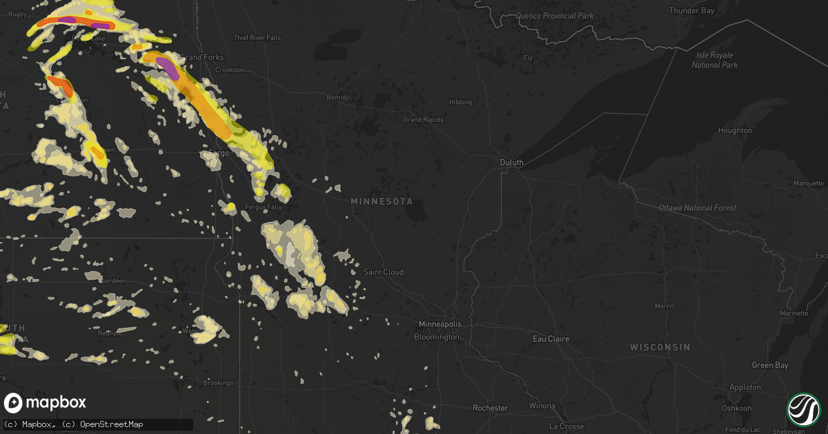
Hail Map in Minnesota on July 9, 2016
Get this storm
July 9 map
$229
one time, instant access
Download today. No call, no setup
Keep the $229
Bought the map and want the full workflow? Apply the entire $229 to a subscription within 7 days. None of it is wasted.
Every map, not just this one
This buys you this map. Subscription and you get every map we run, in the markets you choose from a few cities to whole states to nationwide. Plus real-time alerts the moment a storm fires.
Contact data
Name, contact info, occupancy, even credit band for addresses in the footprint. You go from where it hit to who to call.
Become the source they trust
Unlimited branding weather history reports on demand. You already have the documented answer ready for the property owner, and you are the one who showed up with it.
Property data and RoofTrace estimates
Pull up any address you have got, its value and the exact code rules for that jurisdiction, straight from One Click Code. Then RoofTrace estimates the squares, pitch, and roof value, priced the way you price.
Storm reports in Minnesota
Minnesota
| Date | Description |
|---|---|
| 07/09/20163:54 AM CDT | Large trees uprooted or snapped above ground level. Time estimated from radar. |
| 07/09/20162:14 AM CDT | Measured at the park rapids airport /kpkd/. |
| 07/09/20162:13 AM CDT | 50-60 mph... Radar estimated time. |
| 07/09/20161:55 AM CDT | Large tree uprooted. Picture on facebook. |
| 07/09/20161:40 AM CDT | Large trees broken down. |
| 07/09/20161:40 AM CDT | Hundreds of trees down with some house roofs damaged... Dozen or more power poles snapped... Sheds damaged. Radar estimated time. |
| 07/09/20161:30 AM CDT | Very strong wind as well. |
| 07/09/20161:10 AM CDT | Power poles down 1.5 miles east of town. |
| 07/09/20161:06 AM CDT | Tree limbs down. Picnic table flipped. |
| 07/09/20161:05 AM CDT | Five inch diameter tree limb severed. Bird feeder toppled. |
| 07/09/20161:00 AM CDT | Late report. Several big trees snapped off. |
| 07/09/201612:35 AM CDT | A couple of trees snapped in and around rockwood township...including the city of sebeka. At one farmstead... Several small calf hutches and one large super hutch were |
| 07/09/201612:30 AM CDT | Trees blown down and a barn roof was blown off. Peak winds estimated to 80 mph. |
| 07/09/201612:25 AM CDT | Large branches down. |
| 07/09/201612:25 AM CDT | Large branches down. |
| 07/09/201612:08 AM CDT | Large trees broken down. |
| 07/09/201612:06 AM CDT | Winds estimated at 60 to 70 mph. Large branches breaking down. Power outages. |
| 07/09/201612:06 AM CDT | Winds estimated at 60 to 70 mph. Large branches breaking down. Power outages. |
| 07/08/201611:55 PM CDT | Winds blew down displays at the phelps mill art festival. |
| 07/08/201611:52 PM CDT | Large tree branches broken down. Local power out. Report via social media. |
| 07/08/201611:35 PM CDT | Large maple tree broken down. |
| 07/08/201611:10 PM CDT | Large trees broken down near big comorant lake. Photo and report posted to social media. |
| 07/08/201611:06 PM CDT | A local report indicates 1.25 inch wind near AUDUBON |
| 07/08/201610:45 PM CDT | Report of two large branches broken off an oak tree. Posted via social media. |
| 07/08/201610:40 PM CDT | Driving rain and very strong winds estimated at 50 to 60 mph. Vehicle rocking. |
| 07/08/201610:20 PM CDT | Steel roofing material torn off of dog kennels. Steel doors caved in storage buildings. Construction trailer blown over and rolled. Trees broken down around town. Time |
| 07/08/20169:45 PM CDT | Lots of nickel to quarter sized hail and very strong winds. |
| 07/08/20169:25 PM CDT | Very strong winds bending trees. Power outage across area. |
All States Impacted by Hail Map on July 9, 2016
Cities Impacted by Hail Map on July 9, 2016
- Fort Pierre, SD
- Brooten, MN
- Reva, SD
- Niagara, ND
- Michigan, ND
- Brocket, ND
- Dahlen, ND
- Lakota, ND
- Petersburg, ND
- Fordville, ND
- Buffalo, SD
- Alsen, ND
- Fayette, AL
- Bismarck, ND
- Center, ND
- Baldwin, ND
- Saint Lawrence, SD
- Lineville, AL
- Ridgeville, SC
- Summerville, SC
- Golden City, MO
- Reeds, MO
- Seymour, TX
- Hartshorn, MO
- Fort Stockton, TX
- Mountain Grove, MO
- Cherokee, OK
- Ellendale, ND
- Kathryn, ND
- Litchville, ND
- Horace, ND
- Clifford, ND
- Carrington, ND
- New Rockford, ND
- Calera, OK
- Cartwright, OK
- Buchanan, ND
- Solen, ND
- Grandin, ND
- Bellevue, TX
- Collinsville, TX
- Valley View, TX
- Gainesville, TX
- Battle Lake, MN
- Elbow Lake, MN
- Aliceville, AL
- Pelican Rapids, MN
- Audubon, MN
- Lake Park, MN
- Hawley, MN
- Jamestown, ND
- Northwood, ND
- Meadow, SD
- Lemmon, SD
- Clanton, AL
- Jemison, AL
- Arvilla, ND
- Emerado, ND
- Larimore, ND
- Burneyville, OK
- Clear Lake, SD
- Medina, ND
- Carson, ND
- Raleigh, ND
- Watauga, SD
- Shields, ND
- Keldron, SD
- Selfridge, ND
- Morristown, SD
- Churchs Ferry, ND
- Leeds, ND
- Lankin, ND
- Lawton, ND
- Penn, ND
- York, ND
- Devils Lake, ND
- Starkweather, ND
- Hampden, ND
- Rugby, ND
- Edmore, ND
- Crary, ND
- Munich, ND
- Esmond, ND
- Webster, ND
- Cando, ND
- Hitchcock, SD
- Wessington, SD
- Ypsilanti, ND
- Manchester, GA
- Zeeland, ND
- Wishek, ND
- Sunburg, MN
- Fitzgerald, GA
- Rochelle, GA
- Cloudcroft, NM
- Ashley, ND
- Lehr, ND
- Cody, WY
- Gordon, AL
- Donalsonville, GA
- Bascom, FL
- Laurel, MS
- Ellisville, MS
- Tappen, ND
- Edgar Springs, MO
- Eastman, GA
- Olney, TX
- Rosholt, SD
- Hendrum, MN
- Perley, MN
- Onida, SD
- Crawford, MS
- Starkville, MS
- Jackson, GA
- Opp, AL
- Kinston, AL
- Elba, AL
- Murdock, MN
- Benson, MN
- Argusville, ND
- Gardner, ND
- Arthur, ND
- Glenwood, GA
- Reynolds, GA
- Rupert, GA
- Butler, GA
- Edgeley, ND
- Pierre, SD
- Brooklet, GA
- Hollywood, SC
- Dallas, TX
- Woodworth, ND
- Pettibone, ND
- Thomaston, GA
- Thompson, ND
- Webster, SD
- Ringgold, TX
- Nocona, TX
- Bowie, TX
- Lapine, AL
- Mankato, MN
- Garfield, MN
- Newell, SD
- Belle Fourche, SD
- Bridgeport, TX
- Cochran, GA
- Gunter, TX
- Eutaw, AL
- Ridgeland, SC
- Wells, MN
- Kosciusko, MS
- Carthage, MS
- Coffeeville, MS
- New London, MN
- Belgrade, MN
- Kandiyohi, MN
- Spicer, MN
- Atwater, MN
- Myrtle Beach, SC
- Murrells Inlet, SC
- New Leipzig, ND
- Jasper, AL
- Everton, MO
- Ash Grove, MO
- Eden Valley, MN
- Watkins, MN
- Daviston, AL
- Cedar Hill, TX
- Grand Prairie, TX
- Pennock, MN
- Willmar, MN
- Waynesville, MO
- Napoleon, ND
- Kintyre, ND
- Delta, AL
- Merriman, NE
- Metter, GA
- Millville, NJ
- Bridgeton, NJ
- Shiloh, NJ
- Greenwich, NJ
- Cedarville, NJ
- Mcville, ND
- Linn Creek, MO
- Camdenton, MO
- Hollandale, MS
- Cohagen, MT
- Silverton, TX
- Wadley, AL
- Wedowee, AL
- Roanoke, AL
- Mauk, GA
- Buena Vista, GA
- Finley, ND
- Stanton, ND
- New Salem, ND
- Aberdeen, SD
- Westport, SD
- Ipswich, SD
- Northville, SD
- Mansfield, SD
- Notasulga, AL
- Bison, SD
- Uniontown, AL
- Macon, MS
- Shuqualak, MS
- Grandin, MO
- Rake, IA
- Frost, MN
- Buffalo Center, IA
- Clyde, TX
- Abilene, TX
- Decatur, MS
- Little Rock, MS
- Collins, GA
- Hazelton, ND
- Linton, ND
- Plains, GA
- Dawson, GA
- Smithville, GA
- Barnesville, MN
- Pitts, GA
- Springdale, AR
- Walker, MO
- Harwood, MO
- Nevada, MO
- Eureka, SD
- Hosmer, SD
- Gardner, KS
- Edgerton, KS
- Strandburg, SD
- South Shore, SD
- Castlewood, SD
- Goodwin, SD
- Kranzburg, SD
- Watertown, SD
- Hayti, SD
- Brusett, MT
- Winnett, MT
- Sand Springs, MT
- Mosby, MT
- Americus, GA
- Forsyth, GA
- Glenwood, MN
- Starbuck, MN
- Princeton, KS
- Morris, MN
- Correll, MN
- Appleton, MN
- Chokio, MN
- Ellendale, MN
- Frisco City, AL
- Beaverton, AL
- Grass Range, MT
- Oxford, MS
- Ashton, SD
- Cathay, ND
- Holt, FL
- Sawyerville, AL
- Ulen, MN
- Ogema, MN
- Callaway, MN
- Halstad, MN
- Lampasas, TX
- Alden, MN
- Greenville, MS
- Denison, TX
- Opelika, AL
- Lodgepole, SD
- Okeene, OK
- Ada, MN
- Twin Valley, MN
- Marietta, OK
- Thackerville, OK
- Colbert, OK
- Halliday, ND
- Clarks Grove, MN
- Hollandale, MN
- Geneva, MN
- Hartland, MN
- New Richland, MN
- Pekin, ND
- Harrold, SD
- Hillsboro, GA
- Hillsboro, ND
- Cleveland, ND
- Jud, ND
- Gackle, ND
- Streeter, ND
- Harvey, ND
- Wilton, ND
- Erhard, MN
- Elizabeth, MN
- Mead, OK
- Piedmont, AL
- Fort Yates, ND
- Nelson, MN
- Brandon, MN
- Alexandria, MN
- Miltona, MN
- Osakis, MN
- Lowry, MN
- Carlos, MN
- Evansville, MN
- Parkers Prairie, MN
- Farwell, MN
- Villard, MN
- Sauk Centre, MN
- Kensington, MN
- Hancock, NY
- Beardsley, MN
- Browns Valley, MN
- Georgiana, AL
- Greenville, AL
- El Dorado Springs, MO
- Johns Island, SC
- Mandan, ND
- Birmingham, AL
- Buxton, ND
- Cummings, ND
- Hatton, ND
- Hazlehurst, GA
- Ashby, MN
- Macon, GA
- Maddock, ND
- Oberon, ND
- Morristown, MN
- Mapleton, MN
- Cleveland, AL
- Oneonta, AL
- Hayden, AL
- Centrahoma, OK
- Tupelo, OK
- Webb City, MO
- Joplin, MO
- Okeechobee, FL
- Wakpala, SD
- McLaughlin, SD
- Inkster, ND
- Madrid, NY
- Grey Eagle, MN
- Melrose, MN
- Freeport, MN
- Cusseta, GA
- Flasher, ND
- Plato, MO
- Hobson, MT
- Prairie City, SD
- Milbank, SD
- Carthage, MO
- Jasper, MO
- Dadeville, AL
- Turton, SD
- Conde, SD
- Midland, SD
- Dupree, SD
- Foxhome, MN
- Breckenridge, MN
- Campbell, MN
- Norcross, MN
- Hoffman, MN
- Herman, MN
- Dalton, MN
- Wendell, MN
- Barrett, MN
- Waterville, NY
- Cassville, NY
- Bridgewater, NY
- Loring, MT
- Wolverton, MN
- Pingree, ND
- Sanger, TX
- Wagarville, AL
- Java, SD
- Winter Haven, FL
- Monroeville, AL
- Quitman, MS
- Clontarf, MN
- Lawrence, MS
- Lake, MS
- Conehatta, MS
- Taylor, ND
- Richardton, ND
- Scottsboro, AL
- Thompson, PA
- Pleasant Mount, PA
- Forest City, PA
- Herrick Center, PA
- Waymart, PA
- Honesdale, PA
- Union Dale, PA
- Meridian, MS
- Grapeland, TX
- Harwood, ND
- Felton, MN
- Georgetown, MN
- Borup, MN
- Fairmount, ND
- Estill, SC
- Mellette, SD
- Howe, TX
- Braddock, ND
- Alberta, AL
- Winthrop, NY
- North Lawrence, NY
- Brasher Falls, NY
- McKenzie, AL
- Wellsville, KS
- Catherine, AL
- Claxton, GA
- Altoona, AL
- Attalla, AL
- Gallant, AL
- Brooksville, MS
- Mooreton, ND
- Fort Mitchell, AL
- Dell Rapids, SD
- Rhine, GA
- Jacksonville, GA
- Gray, GA
- Georgetown, SC
- Holabird, SD
- Sulligent, AL
- Guin, AL
- Richville, MN
- Dent, MN
- Salem, MO
- Talladega, AL
- Alpine, AL
- Sycamore, GA
- Oriska, ND
- Phenix City, AL
- Columbus, GA
- Lobelville, TN
- Fort Benning, GA
- Paynesville, MN
- Leola, SD
- Forbes, ND
- Ramer, AL
- Madison, MN
- Ethel, MS
- Portland, ND
- Andrews, SC
- Cobbtown, GA
- Montpelier, ND
- Springfield, CO
- Bankston, AL
- Aberdeen, MS
- Prairie, MS
- Selby, SD
- Underwood, MN
- Muenster, TX
- Cresbard, SD
- Albany, MN
- Moultrie, GA
- Coolidge, GA
- Range, AL
- Brewton, AL
- Repton, AL
- Agar, SD
- Hayes, SD
- Eagle Butte, SD
- Gettysburg, SD
- Cedarbluff, MS
- Saint Jo, TX
- Swainsboro, GA
- Graceville, MN
- Winter Garden, FL
- Sharon, ND
- Forest City, IA
- Aneta, ND
- Shelly, MN
- Caledonia, ND
- Detroit Lakes, MN
- Hitterdal, MN
- Mayville, ND
- Blanchard, ND
- Reynolds, ND
- Galesburg, ND
- Hunter, ND
- Autaugaville, AL
- Enterprise, MS
- Henrietta, TX
- Holcomb, MS
- Elgin, ND
- Redwood Falls, MN
- Jacksboro, TX
- Alma, GA
- Reidsville, GA
- Miller, SD
- Wahpeton, ND
- Abbeville, AL
- Minnesota Lake, MN
- Saint Helena Island, SC
- Buhl, AL
- Fosters, AL
- Lenox, AL
- Castleberry, AL
- Jackson, PA
- Susquehanna, PA
- Lake Preston, SD
- Lena, MS
- Forest, MS
- Redfield, SD
- Samson, AL
- Safford, AL
- Lisbon, ND
- Shiloh, GA
- Woodland, GA
- Fredonia, ND
- Aline, OK
- Burlington, OK
- Dacoma, OK
- Carmen, OK
- Olivia, MN
- Auburn, AL
- Rothsay, MN
- North Bangor, NY
- Fessenden, ND
- Hampton, AR
- Celina, TX
- Evergreen, AL
- Broadview, NM
- Hereford, TX
- Lake Mary, FL
- Longwood, FL
- Lidgerwood, ND
- Okatie, SC
- Mill Creek, OK
- Burnet, TX
- Kerkhoven, MN
- Albert Lea, MN
- Collinsville, MS
- Pineland, SC
- Jermyn, PA
- Carbondale, PA
- Ochlocknee, GA
- Thomasville, GA
- Mathews, AL
- Palm Coast, FL
- Jay, FL
- Aubrey, TX
- Stockton, MO
- Bainbridge, GA
- Jacksons Gap, AL
- Gaylord, MN
- West Point, MS
- Spiritwood, ND
- Sanborn, ND
- Wimbledon, ND
- Calera, AL
- Trinity, TX
- Kulm, ND
- Rebecca, GA
- Maplesville, AL
- Grove Hill, AL
- Sheyenne, ND
- Roslyn, SD
- Pierpont, SD
- Groton, SD
- Stratford, SD
- Shorterville, AL
- Headland, AL
- Newville, AL
- Enderlin, ND
- Fingal, ND
- Page, ND
- Hope, ND
- Pittsview, AL
- Canby, MN
- Lonsdale, MN
- Montgomery, MN
- New Prague, MN
- Juliette, GA
- Hawkinsville, GA
- Fairfield, ND
- Venus, TX
- Ashland, AL
- Madill, OK
- Wadena, MN
- Verndale, MN
- Sebeka, MN
- Faulkton, SD
- Herreid, SD
- Hague, ND
- Lake Mills, IA
- Leland, IA
- Mescalero, NM
- Poplar Bluff, MO
- Holloway, MN
- Thompson, IA
- Lake Village, AR
- Hamilton, GA
- Walnut Grove, MS
- Fergus Falls, MN
- Columbus, MS
- Baxley, GA
- Lafayette, AL
- Brushton, NY
- Moira, NY
- Camp Hill, AL
- Sherman, TX
- Howard Lake, MN
- Manning, ND
- Gladstone, ND
- Springville, AL
- Remlap, AL
- Milburn, OK
- Vernon, AL
- West Winfield, NY
- Richland, GA
- Omaha, GA
- Bricelyn, MN
- Langdon, ND
- Winthrop, MN
- Whitesboro, TX
- Springfield, GA
- Guyton, GA
- Winfield, AL
- Robertsdale, AL
- Summersville, MO
- Cyrus, MN
- Clara City, MN
- Raymond, MN
- Donnelly, MN
- Grove City, MN
- Danvers, MN
- Montevideo, MN
- Maynard, MN
- Ocilla, GA
- Glyndon, MN
- Eminence, MO
- Whigham, GA
- Breckenridge, TX
- Graham, TX
- Graford, TX
- Wolford, ND
- Lewellen, NE
- Sonora, TX
- Claremont, SD
- Canton, NY
- Norwood, NY
- Potsdam, NY
- Culloden, GA
- Milan, GA
- Calvin, ND
- Wales, ND
- Cadwell, GA
- Andalusia, AL
- Winsted, MN
- Ellington, MO
- Roscoe, SD
- Grenada, MS
- Gore Springs, MS
- Hankinson, ND
- Boligee, AL
- Sykeston, ND
- Robinson, ND
- Strawn, TX
- Clinton, MN
- Ortonville, MN
- Corona, SD
- Glennville, GA
- Vale, SD
- Bellingham, MN
- Saint Michael, ND
- Pansey, AL
- Monticello, GA
- Salem, NJ
- Tower City, ND
- Swanquarter, NC
- Shellman, GA
- Cuthbert, GA
- Parrott, GA
- Watertown, MN
- Colfax, ND
- Winona, MS
- Duck Hill, MS
- Onaka, SD
- Mansfield, GA
- Vienna, GA
- Pinehurst, GA
- Climax, GA
- Milnor, ND
- Fullerton, ND
- Berlin, ND
- Hardeeville, SC
- Whatley, AL
- De Smet, SD
- Iroquois, SD
- Tulare, SD
- Seagoville, TX
- Centerville, KS
- Dickinson, ND
- Salem, AL
- Windermere, FL
- Orlando, FL
- Tuskegee, AL
- Merigold, MS
- Cooperstown, ND
- Darwin, MN
- Litchfield, MN
- Macks Creek, MO
- Deposit, NY
- Boaz, AL
- Fargo, ND
- Moorhead, MN
- West Fargo, ND
- Mapleton, ND
- Carrollton, MS
- Moffit, ND
- Hancock, MN
- Gallion, AL
- Coleman, GA
- Northwood, IA
- Sheldon, ND
- Leonard, ND
- Roach, MO
- Hope Hull, AL
- Montgomery, AL
- Hector, MN
- Newburg, MO
- Verona, ND
- Fort Ransom, ND
- Brentford, SD
- Warner, SD
- Rockham, SD
- Greensboro, AL
- Frankfort, SD
- Doland, SD
- Bunker, MO
- Ortley, SD
- Hazen, ND
- Beulah, ND
- Richmond, MN
- Rolla, MO
- Alto, TX
- Walsh, CO
- Andover, SD
- Pike Road, AL
- Philadelphia, MS
- Union, MS
- Ovett, MS
- Pine Mountain Valley, GA
- Nineveh, NY
- Harpursville, NY
- Malta, MT
- Edisto Island, SC
- Jakin, GA
- Luverne, AL
- Goshen, AL
- Charleston, MS
- Bluffton, SC
- Hilton Head Island, SC
- Camilla, GA
- Northport, AL
- Berry, AL
- Luverne, MN
- Blakely, GA
- Mound City, KS
- Statesboro, GA
- Dawson, MN
- Milan, MN
- Langford, SD
- Marion, ND
- Randolph, MS
- Port Royal, SC
- Beaufort, SC
- Windsor, NY
- Covington, GA
- Georgetown, TX
- Florence, TX
- Portal, GA
- Akron, AL
- Mathiston, MS
- Waseca, MN
- Ogdensburg, NY
- Lisbon, NY
- Gainesville, AL
- Wolsey, SD
- Jacksonboro, SC
- Adams Run, SC
- Delavan, MN
- Fultonham, NY
- Richmondville, NY
- West Fulton, NY
- Warnerville, NY
- Prompton, PA
- Colquitt, GA
- Emmons, MN
- Huron, SD
- Vergas, MN
- Brockton, MT
- Auburn University, AL
- Batesville, MS
- Red Lodge, MT
- Hamburg, AR
- Dumont, MN
- Fairdealing, MO
- Doniphan, MO
- Ottertail, MN
- Newington, GA
- Porcupine, SD
- Marks, MS
- Rochert, MN
- Ozona, TX
- Columbia, AL
- Vredenburgh, AL
- Franklin, AL
- Odessa, MN
- Big Stone City, SD
- Cascilla, MS
- Chateaugay, NY
- Colman, SD
- Chester, SD
- Kingston, OK
- Milton, FL
- Forest River, ND
- Gilby, ND
- Billingsley, AL
- Chester, GA
- Walton, NY
- Downsville, NY
- Clyo, GA
- Jackson, AL
- Saint Stephens, AL
- Chatom, AL
- Marion Junction, AL
- Good Thunder, MN
- Fort Gaines, GA
- Groveoak, AL
- Willow Lake, SD
- Bryant, SD
- Volga, SD
- Sylacauga, AL
- Weogufka, AL
- Rockford, AL
- Hay Springs, NE
- Franklin, MN
- West Chester, PA
- Chadds Ford, PA
- Wilmington, DE
- Rockland, DE
- Montchanin, DE
- Kennett Square, PA
- Paradise, TX
- Springtown, TX
- Henry, SD
- Garden City, SD
- Midville, GA
- Garfield, GA
- Twin City, GA
- Elysian, MN
- Prattville, AL
- Equinunk, PA
- Throckmorton, TX
- Gordon, GA
- Milledgeville, GA
- McIntyre, GA
- Jasper, MN
- Kansas City, KS
- Union Springs, AL
- Eupora, MS
- Mayhill, NM
- Parrish, AL
- Baker, FL
- Shaw, MS
- Leland, MS
- Indianola, MS
- Wann, OK
- Copan, OK
- Carpenter, SD
- Yale, SD
- Florala, AL
- Lockhart, AL
- Laurel Hill, FL
- Midlothian, TX
- Clarksdale, MS
- Tutwiler, MS
- Duncan, MS
- Lead, SD
- Miller, MO
- Mount Vernon, MO
- Pontotoc, MS
- Wheaton, MN
- Weir, MS
- Fairfax, MN
- Yatesville, GA
- McDavid, FL
- Minnewaukan, ND
- Pineview, GA
- Lamar, MO
- Owatonna, MN
- Mansfield, TX
- Idaho Falls, ID
- Roberts, ID
- Tennille, GA
- Yemassee, SC
- Kaufman, TX
- La Russell, MO
- Lockwood, MO
- Whitman, NE
- Water Valley, MS
- Banner, MS
- Long Lake, SD
- Lucan, MN
- Walnut Grove, MN
- South Greenfield, MO
- Newbern, AL
- Moncks Corner, SC
- Bowdle, SD
- Kingsley, PA
- Hop Bottom, PA
- Seabrook, SC
- Hermitage, AR
- Cannon Ball, ND
- Pemberton, MN
- Janesville, MN
- Valley City, ND
- Luverne, ND
- Altamonte Springs, FL
- Yazoo City, MS
- Cayuga, ND
- Joice, IA
- Staples, MN
- Kemp, TX
- Tuscaloosa, AL
- Ralph, AL
- East Branch, NY
- Allentown, PA
- Whitehall, PA
- Dothan, AL
- Kent, MN
- Bowdon, ND
- Kensal, ND
- Dawson, ND
- Dickey, ND
- Carrollton, AL
- Churubusco, NY
- Oakes, ND
- Fitzpatrick, AL
- Jones, AL
- Midland City, AL
- Milroy, MN
- Sunrise Beach, MO
- Centreville, AL
- Brent, AL
- Courtenay, ND
- Eagle Lake, MN
- Richland, MO
- Cushing, MN
- Pottsboro, TX
- Raymond, SD
- Desoto, TX
- Tyro, KS
- Caney, KS
- Verbena, AL
- Pollock, SD
- Eatonton, GA
- Aragon, GA
- Spring Hill, KS
- Rincon, GA
- Lakewood, PA
- Arthur, NE
- Mentone, AL
- Fort Payne, AL
- Valley Head, AL
- Locust Grove, GA
- Drew, MS
- Oakman, AL
- Fairfield, AL
- Sturgis, MS
- Van Alstyne, TX
- Kansas City, MO
- Parker, KS
- Waldorf, MN
- Easton, MN
- Rutland, SD
- Winona, MO
- Bruce, MS
- Hamilton, TX
- Cedar Bluff, AL
- Highmore, SD
- Bamberg, SC
- Stotts City, MO
- Louisville, GA
- Como, TX
- Oldham, SD
- Arlington, SD
- Ree Heights, SD
- Greenwood, MS
- Overbrook, OK
- Egeland, ND
- Nielsville, MN
- Adams, ND
- Climax, MN
- Fairdale, ND
- Porter, MN
- Clark, SD
- Forney, TX
- McCool, MS
- Ardmore, OK
- Sumner, MS
- Lewistown, MT
- Cairo, GA
- Woodson, TX
- Scurry, TX
- Laquey, MO
- Falcon, MO
- Lebanon, MO
- New York Mills, MN
- Sidney, NE
- Gurley, NE
- Pilot Point, TX
- Mccall, ID
- Summit, SD
- Abbeville, GA
- Osage Beach, MO
- Montreal, MO
- Cosmos, MN
- Dickinson Center, NY
- Eudora, AR
- Attapulgus, GA
- Hazel, SD
- Pritchett, CO


