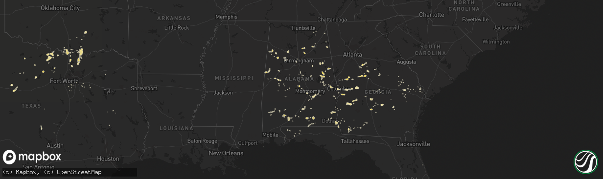
Hail Map in Alabama on July 9, 2016
The weather event in Alabama on July 9, 2016 includes Hail map. 26 states and 1,025 cities were impacted and suffered possible damage. The total estimated number of properties impacted is 0.
Want more than just the map?
Turn this storm into a full workflow.
- Owner + property data so you know who to knock
- OnDemand branded weather history reports to win the "did we even have hail?" argument
- RoofTrace estimate so reps stop guessing numbers at the door
Bought this map? Upgrade within 7 days and we'll credit the $230. (10-15 min setup call)
Hail
0
Estimated number of impacted properties by a 1.00" hail or larger0
Estimated number of impacted properties by a 1.75" hail or larger0
Estimated number of impacted properties by a 2.50" hail or largerStorm reports in Alabama
Alabama
| Date | Description |
|---|---|
| 07/09/20166:35 PM CDT | Report of tree down over power line in ashford |
| 07/09/20165:42 PM CDT | Tree down on viking dr and 20th ave |
| 07/09/20165:24 PM CDT | Tree down on hwy 69n near boldo |
| 07/09/20165:20 PM CDT | Trees and power lines down. Estimated 40 to 50 mile per hour winds. Street flooding reported in downtown jasper with town creek out of its banks. Street flooding with w |
| 07/09/20164:45 PM CDT | Reports of trees down along hwy 427 |
| 07/09/20164:45 PM CDT | Reports trees down along hwy 189 n. Between kingston and elba. |
| 07/09/20164:25 PM CDT | Trees and power lines down at yellow creek campground. |
| 07/09/20164:20 PM CDT | Power lines down on alabama ave and 16 ave |
| 07/09/20164:19 PM CDT | Power lines down on pike road |
| 07/09/20164:19 PM CDT | Power lines down on lown ave |
| 07/09/20164:18 PM CDT | *** 1 inj *** tree down on structure at 1841 st.charles street...1 injury reported |
| 07/09/20164:15 PM CDT | Large tree limbs/branches down greater than 2in |
| 07/09/20162:50 PM CDT | Tree down on dudleyville rd. Location and time estimated. |
| 07/09/20162:34 PM CDT | Gadsden asos reports tstm wind gust at 51kts and 42kts sustained |
| 07/09/20162:20 PM CDT | Power lines down at 835 egypt road...est wind speed 40-50mph |
| 07/09/20162:05 PM CDT | Three trees reported down... One along county road 19 and two along county road 38. Location approximate. Time estimated. |
| 07/09/20161:32 PM CDT | Tree fell onto car in phenix city. |
| 07/09/20161:23 PM CDT | Power line down on road near beauregard near intersection of lee county road 112 and lee county road 414. |
| 07/09/20161:15 PM CDT | Tree down on intersection of cr12 and cr29 est wind speed at 40-50mph |
| 07/09/20169:58 AM CDT | Trees and power lines down. Estimated 40 to 50 mile per hour winds. Street flooding reported in downtown jasper with town creek out of its banks. Street flooding with w |
| 07/08/20167:21 PM CDT | Two trees were knocked down along langston road near the water plant. Time estimated by radar. |
All States Impacted by Hail Map on July 9, 2016
Cities Impacted by Hail Map on July 9, 2016
- Fort Pierre, SD
- Brooten, MN
- Reva, SD
- Niagara, ND
- Michigan, ND
- Brocket, ND
- Dahlen, ND
- Lakota, ND
- Petersburg, ND
- Fordville, ND
- Buffalo, SD
- Alsen, ND
- Fayette, AL
- Bismarck, ND
- Center, ND
- Baldwin, ND
- Saint Lawrence, SD
- Lineville, AL
- Ridgeville, SC
- Summerville, SC
- Golden City, MO
- Reeds, MO
- Seymour, TX
- Hartshorn, MO
- Fort Stockton, TX
- Mountain Grove, MO
- Cherokee, OK
- Ellendale, ND
- Kathryn, ND
- Litchville, ND
- Horace, ND
- Clifford, ND
- Carrington, ND
- New Rockford, ND
- Calera, OK
- Cartwright, OK
- Buchanan, ND
- Solen, ND
- Grandin, ND
- Bellevue, TX
- Collinsville, TX
- Valley View, TX
- Gainesville, TX
- Battle Lake, MN
- Elbow Lake, MN
- Aliceville, AL
- Pelican Rapids, MN
- Audubon, MN
- Lake Park, MN
- Hawley, MN
- Jamestown, ND
- Northwood, ND
- Meadow, SD
- Lemmon, SD
- Clanton, AL
- Jemison, AL
- Arvilla, ND
- Emerado, ND
- Larimore, ND
- Burneyville, OK
- Clear Lake, SD
- Medina, ND
- Carson, ND
- Raleigh, ND
- Watauga, SD
- Shields, ND
- Keldron, SD
- Selfridge, ND
- Morristown, SD
- Churchs Ferry, ND
- Leeds, ND
- Lankin, ND
- Lawton, ND
- Penn, ND
- York, ND
- Devils Lake, ND
- Starkweather, ND
- Hampden, ND
- Rugby, ND
- Edmore, ND
- Crary, ND
- Munich, ND
- Esmond, ND
- Webster, ND
- Cando, ND
- Hitchcock, SD
- Wessington, SD
- Ypsilanti, ND
- Manchester, GA
- Zeeland, ND
- Wishek, ND
- Sunburg, MN
- Fitzgerald, GA
- Rochelle, GA
- Cloudcroft, NM
- Ashley, ND
- Lehr, ND
- Cody, WY
- Gordon, AL
- Donalsonville, GA
- Bascom, FL
- Laurel, MS
- Ellisville, MS
- Tappen, ND
- Edgar Springs, MO
- Eastman, GA
- Olney, TX
- Rosholt, SD
- Hendrum, MN
- Perley, MN
- Onida, SD
- Crawford, MS
- Starkville, MS
- Jackson, GA
- Opp, AL
- Kinston, AL
- Elba, AL
- Murdock, MN
- Benson, MN
- Argusville, ND
- Gardner, ND
- Arthur, ND
- Glenwood, GA
- Reynolds, GA
- Rupert, GA
- Butler, GA
- Edgeley, ND
- Pierre, SD
- Brooklet, GA
- Hollywood, SC
- Dallas, TX
- Woodworth, ND
- Pettibone, ND
- Thomaston, GA
- Thompson, ND
- Webster, SD
- Ringgold, TX
- Nocona, TX
- Bowie, TX
- Lapine, AL
- Mankato, MN
- Garfield, MN
- Newell, SD
- Belle Fourche, SD
- Bridgeport, TX
- Cochran, GA
- Gunter, TX
- Eutaw, AL
- Ridgeland, SC
- Wells, MN
- Kosciusko, MS
- Carthage, MS
- Coffeeville, MS
- New London, MN
- Belgrade, MN
- Kandiyohi, MN
- Spicer, MN
- Atwater, MN
- Myrtle Beach, SC
- Murrells Inlet, SC
- New Leipzig, ND
- Jasper, AL
- Everton, MO
- Ash Grove, MO
- Eden Valley, MN
- Watkins, MN
- Daviston, AL
- Cedar Hill, TX
- Grand Prairie, TX
- Pennock, MN
- Willmar, MN
- Waynesville, MO
- Napoleon, ND
- Kintyre, ND
- Delta, AL
- Merriman, NE
- Metter, GA
- Millville, NJ
- Bridgeton, NJ
- Shiloh, NJ
- Greenwich, NJ
- Cedarville, NJ
- Mcville, ND
- Linn Creek, MO
- Camdenton, MO
- Hollandale, MS
- Cohagen, MT
- Silverton, TX
- Wadley, AL
- Wedowee, AL
- Roanoke, AL
- Mauk, GA
- Buena Vista, GA
- Finley, ND
- Stanton, ND
- New Salem, ND
- Aberdeen, SD
- Westport, SD
- Ipswich, SD
- Northville, SD
- Mansfield, SD
- Notasulga, AL
- Bison, SD
- Uniontown, AL
- Macon, MS
- Shuqualak, MS
- Grandin, MO
- Rake, IA
- Frost, MN
- Buffalo Center, IA
- Clyde, TX
- Abilene, TX
- Decatur, MS
- Little Rock, MS
- Collins, GA
- Hazelton, ND
- Linton, ND
- Plains, GA
- Dawson, GA
- Smithville, GA
- Barnesville, MN
- Pitts, GA
- Springdale, AR
- Walker, MO
- Harwood, MO
- Nevada, MO
- Eureka, SD
- Hosmer, SD
- Gardner, KS
- Edgerton, KS
- Strandburg, SD
- South Shore, SD
- Castlewood, SD
- Goodwin, SD
- Kranzburg, SD
- Watertown, SD
- Hayti, SD
- Brusett, MT
- Winnett, MT
- Sand Springs, MT
- Mosby, MT
- Americus, GA
- Forsyth, GA
- Glenwood, MN
- Starbuck, MN
- Princeton, KS
- Morris, MN
- Correll, MN
- Appleton, MN
- Chokio, MN
- Ellendale, MN
- Frisco City, AL
- Beaverton, AL
- Grass Range, MT
- Oxford, MS
- Ashton, SD
- Cathay, ND
- Holt, FL
- Sawyerville, AL
- Ulen, MN
- Ogema, MN
- Callaway, MN
- Halstad, MN
- Lampasas, TX
- Alden, MN
- Greenville, MS
- Denison, TX
- Opelika, AL
- Lodgepole, SD
- Okeene, OK
- Ada, MN
- Twin Valley, MN
- Marietta, OK
- Thackerville, OK
- Colbert, OK
- Halliday, ND
- Clarks Grove, MN
- Hollandale, MN
- Geneva, MN
- Hartland, MN
- New Richland, MN
- Pekin, ND
- Harrold, SD
- Hillsboro, GA
- Hillsboro, ND
- Cleveland, ND
- Jud, ND
- Gackle, ND
- Streeter, ND
- Harvey, ND
- Wilton, ND
- Erhard, MN
- Elizabeth, MN
- Mead, OK
- Piedmont, AL
- Fort Yates, ND
- Nelson, MN
- Brandon, MN
- Alexandria, MN
- Miltona, MN
- Osakis, MN
- Lowry, MN
- Carlos, MN
- Evansville, MN
- Parkers Prairie, MN
- Farwell, MN
- Villard, MN
- Sauk Centre, MN
- Kensington, MN
- Hancock, NY
- Beardsley, MN
- Browns Valley, MN
- Georgiana, AL
- Greenville, AL
- El Dorado Springs, MO
- Johns Island, SC
- Mandan, ND
- Birmingham, AL
- Buxton, ND
- Cummings, ND
- Hatton, ND
- Hazlehurst, GA
- Ashby, MN
- Macon, GA
- Maddock, ND
- Oberon, ND
- Morristown, MN
- Mapleton, MN
- Cleveland, AL
- Oneonta, AL
- Hayden, AL
- Centrahoma, OK
- Tupelo, OK
- Webb City, MO
- Joplin, MO
- Okeechobee, FL
- Wakpala, SD
- McLaughlin, SD
- Inkster, ND
- Madrid, NY
- Grey Eagle, MN
- Melrose, MN
- Freeport, MN
- Cusseta, GA
- Flasher, ND
- Plato, MO
- Hobson, MT
- Prairie City, SD
- Milbank, SD
- Carthage, MO
- Jasper, MO
- Dadeville, AL
- Turton, SD
- Conde, SD
- Midland, SD
- Dupree, SD
- Foxhome, MN
- Breckenridge, MN
- Campbell, MN
- Norcross, MN
- Hoffman, MN
- Herman, MN
- Dalton, MN
- Wendell, MN
- Barrett, MN
- Waterville, NY
- Cassville, NY
- Bridgewater, NY
- Loring, MT
- Wolverton, MN
- Pingree, ND
- Sanger, TX
- Wagarville, AL
- Java, SD
- Winter Haven, FL
- Monroeville, AL
- Quitman, MS
- Clontarf, MN
- Lawrence, MS
- Lake, MS
- Conehatta, MS
- Taylor, ND
- Richardton, ND
- Scottsboro, AL
- Thompson, PA
- Pleasant Mount, PA
- Forest City, PA
- Herrick Center, PA
- Waymart, PA
- Honesdale, PA
- Union Dale, PA
- Meridian, MS
- Grapeland, TX
- Harwood, ND
- Felton, MN
- Georgetown, MN
- Borup, MN
- Fairmount, ND
- Estill, SC
- Mellette, SD
- Howe, TX
- Braddock, ND
- Alberta, AL
- Winthrop, NY
- North Lawrence, NY
- Brasher Falls, NY
- McKenzie, AL
- Wellsville, KS
- Catherine, AL
- Claxton, GA
- Altoona, AL
- Attalla, AL
- Gallant, AL
- Brooksville, MS
- Mooreton, ND
- Fort Mitchell, AL
- Dell Rapids, SD
- Rhine, GA
- Jacksonville, GA
- Gray, GA
- Georgetown, SC
- Holabird, SD
- Sulligent, AL
- Guin, AL
- Richville, MN
- Dent, MN
- Salem, MO
- Talladega, AL
- Alpine, AL
- Sycamore, GA
- Oriska, ND
- Phenix City, AL
- Columbus, GA
- Lobelville, TN
- Fort Benning, GA
- Paynesville, MN
- Leola, SD
- Forbes, ND
- Ramer, AL
- Madison, MN
- Ethel, MS
- Portland, ND
- Andrews, SC
- Cobbtown, GA
- Montpelier, ND
- Springfield, CO
- Bankston, AL
- Aberdeen, MS
- Prairie, MS
- Selby, SD
- Underwood, MN
- Muenster, TX
- Cresbard, SD
- Albany, MN
- Moultrie, GA
- Coolidge, GA
- Range, AL
- Brewton, AL
- Repton, AL
- Agar, SD
- Hayes, SD
- Eagle Butte, SD
- Gettysburg, SD
- Cedarbluff, MS
- Saint Jo, TX
- Swainsboro, GA
- Graceville, MN
- Winter Garden, FL
- Sharon, ND
- Forest City, IA
- Aneta, ND
- Shelly, MN
- Caledonia, ND
- Detroit Lakes, MN
- Hitterdal, MN
- Mayville, ND
- Blanchard, ND
- Reynolds, ND
- Galesburg, ND
- Hunter, ND
- Autaugaville, AL
- Enterprise, MS
- Henrietta, TX
- Holcomb, MS
- Elgin, ND
- Redwood Falls, MN
- Jacksboro, TX
- Alma, GA
- Reidsville, GA
- Miller, SD
- Wahpeton, ND
- Abbeville, AL
- Minnesota Lake, MN
- Saint Helena Island, SC
- Buhl, AL
- Fosters, AL
- Lenox, AL
- Castleberry, AL
- Jackson, PA
- Susquehanna, PA
- Lake Preston, SD
- Lena, MS
- Forest, MS
- Redfield, SD
- Samson, AL
- Safford, AL
- Lisbon, ND
- Shiloh, GA
- Woodland, GA
- Fredonia, ND
- Aline, OK
- Burlington, OK
- Dacoma, OK
- Carmen, OK
- Olivia, MN
- Auburn, AL
- Rothsay, MN
- North Bangor, NY
- Fessenden, ND
- Hampton, AR
- Celina, TX
- Evergreen, AL
- Broadview, NM
- Hereford, TX
- Lake Mary, FL
- Longwood, FL
- Lidgerwood, ND
- Okatie, SC
- Mill Creek, OK
- Burnet, TX
- Kerkhoven, MN
- Albert Lea, MN
- Collinsville, MS
- Pineland, SC
- Jermyn, PA
- Carbondale, PA
- Ochlocknee, GA
- Thomasville, GA
- Mathews, AL
- Palm Coast, FL
- Jay, FL
- Aubrey, TX
- Stockton, MO
- Bainbridge, GA
- Jacksons Gap, AL
- Gaylord, MN
- West Point, MS
- Spiritwood, ND
- Sanborn, ND
- Wimbledon, ND
- Calera, AL
- Trinity, TX
- Kulm, ND
- Rebecca, GA
- Maplesville, AL
- Grove Hill, AL
- Sheyenne, ND
- Roslyn, SD
- Pierpont, SD
- Groton, SD
- Stratford, SD
- Shorterville, AL
- Headland, AL
- Newville, AL
- Enderlin, ND
- Fingal, ND
- Page, ND
- Hope, ND
- Pittsview, AL
- Canby, MN
- Lonsdale, MN
- Montgomery, MN
- New Prague, MN
- Juliette, GA
- Hawkinsville, GA
- Fairfield, ND
- Venus, TX
- Ashland, AL
- Madill, OK
- Wadena, MN
- Verndale, MN
- Sebeka, MN
- Faulkton, SD
- Herreid, SD
- Hague, ND
- Lake Mills, IA
- Leland, IA
- Mescalero, NM
- Poplar Bluff, MO
- Holloway, MN
- Thompson, IA
- Lake Village, AR
- Hamilton, GA
- Walnut Grove, MS
- Fergus Falls, MN
- Columbus, MS
- Baxley, GA
- Lafayette, AL
- Brushton, NY
- Moira, NY
- Camp Hill, AL
- Sherman, TX
- Howard Lake, MN
- Manning, ND
- Gladstone, ND
- Springville, AL
- Remlap, AL
- Milburn, OK
- Vernon, AL
- West Winfield, NY
- Richland, GA
- Omaha, GA
- Bricelyn, MN
- Langdon, ND
- Winthrop, MN
- Whitesboro, TX
- Springfield, GA
- Guyton, GA
- Winfield, AL
- Robertsdale, AL
- Summersville, MO
- Cyrus, MN
- Clara City, MN
- Raymond, MN
- Donnelly, MN
- Grove City, MN
- Danvers, MN
- Montevideo, MN
- Maynard, MN
- Ocilla, GA
- Glyndon, MN
- Eminence, MO
- Whigham, GA
- Breckenridge, TX
- Graham, TX
- Graford, TX
- Wolford, ND
- Lewellen, NE
- Sonora, TX
- Claremont, SD
- Canton, NY
- Norwood, NY
- Potsdam, NY
- Culloden, GA
- Milan, GA
- Calvin, ND
- Wales, ND
- Cadwell, GA
- Andalusia, AL
- Winsted, MN
- Ellington, MO
- Roscoe, SD
- Grenada, MS
- Gore Springs, MS
- Hankinson, ND
- Boligee, AL
- Sykeston, ND
- Robinson, ND
- Strawn, TX
- Clinton, MN
- Ortonville, MN
- Corona, SD
- Glennville, GA
- Vale, SD
- Bellingham, MN
- Saint Michael, ND
- Pansey, AL
- Monticello, GA
- Salem, NJ
- Tower City, ND
- Swanquarter, NC
- Shellman, GA
- Cuthbert, GA
- Parrott, GA
- Watertown, MN
- Colfax, ND
- Winona, MS
- Duck Hill, MS
- Onaka, SD
- Mansfield, GA
- Vienna, GA
- Pinehurst, GA
- Climax, GA
- Milnor, ND
- Fullerton, ND
- Berlin, ND
- Hardeeville, SC
- Whatley, AL
- De Smet, SD
- Iroquois, SD
- Tulare, SD
- Seagoville, TX
- Centerville, KS
- Dickinson, ND
- Salem, AL
- Windermere, FL
- Orlando, FL
- Tuskegee, AL
- Merigold, MS
- Cooperstown, ND
- Darwin, MN
- Litchfield, MN
- Macks Creek, MO
- Deposit, NY
- Boaz, AL
- Fargo, ND
- Moorhead, MN
- West Fargo, ND
- Mapleton, ND
- Carrollton, MS
- Moffit, ND
- Hancock, MN
- Gallion, AL
- Coleman, GA
- Northwood, IA
- Sheldon, ND
- Leonard, ND
- Roach, MO
- Hope Hull, AL
- Montgomery, AL
- Hector, MN
- Newburg, MO
- Verona, ND
- Fort Ransom, ND
- Brentford, SD
- Warner, SD
- Rockham, SD
- Greensboro, AL
- Frankfort, SD
- Doland, SD
- Bunker, MO
- Ortley, SD
- Hazen, ND
- Beulah, ND
- Richmond, MN
- Rolla, MO
- Alto, TX
- Walsh, CO
- Andover, SD
- Pike Road, AL
- Philadelphia, MS
- Union, MS
- Ovett, MS
- Pine Mountain Valley, GA
- Nineveh, NY
- Harpursville, NY
- Malta, MT
- Edisto Island, SC
- Jakin, GA
- Luverne, AL
- Goshen, AL
- Charleston, MS
- Bluffton, SC
- Hilton Head Island, SC
- Camilla, GA
- Northport, AL
- Berry, AL
- Luverne, MN
- Blakely, GA
- Mound City, KS
- Statesboro, GA
- Dawson, MN
- Milan, MN
- Langford, SD
- Marion, ND
- Randolph, MS
- Port Royal, SC
- Beaufort, SC
- Windsor, NY
- Covington, GA
- Georgetown, TX
- Florence, TX
- Portal, GA
- Akron, AL
- Mathiston, MS
- Waseca, MN
- Ogdensburg, NY
- Lisbon, NY
- Gainesville, AL
- Wolsey, SD
- Jacksonboro, SC
- Adams Run, SC
- Delavan, MN
- Fultonham, NY
- Richmondville, NY
- West Fulton, NY
- Warnerville, NY
- Prompton, PA
- Colquitt, GA
- Emmons, MN
- Huron, SD
- Vergas, MN
- Brockton, MT
- Auburn University, AL
- Batesville, MS
- Red Lodge, MT
- Hamburg, AR
- Dumont, MN
- Fairdealing, MO
- Doniphan, MO
- Ottertail, MN
- Newington, GA
- Porcupine, SD
- Marks, MS
- Rochert, MN
- Ozona, TX
- Columbia, AL
- Vredenburgh, AL
- Franklin, AL
- Odessa, MN
- Big Stone City, SD
- Cascilla, MS
- Chateaugay, NY
- Colman, SD
- Chester, SD
- Kingston, OK
- Milton, FL
- Forest River, ND
- Gilby, ND
- Billingsley, AL
- Chester, GA
- Walton, NY
- Downsville, NY
- Clyo, GA
- Jackson, AL
- Saint Stephens, AL
- Chatom, AL
- Marion Junction, AL
- Good Thunder, MN
- Fort Gaines, GA
- Groveoak, AL
- Willow Lake, SD
- Bryant, SD
- Volga, SD
- Sylacauga, AL
- Weogufka, AL
- Rockford, AL
- Hay Springs, NE
- Franklin, MN
- West Chester, PA
- Chadds Ford, PA
- Wilmington, DE
- Rockland, DE
- Montchanin, DE
- Kennett Square, PA
- Paradise, TX
- Springtown, TX
- Henry, SD
- Garden City, SD
- Midville, GA
- Garfield, GA
- Twin City, GA
- Elysian, MN
- Prattville, AL
- Equinunk, PA
- Throckmorton, TX
- Gordon, GA
- Milledgeville, GA
- McIntyre, GA
- Jasper, MN
- Kansas City, KS
- Union Springs, AL
- Eupora, MS
- Mayhill, NM
- Parrish, AL
- Baker, FL
- Shaw, MS
- Leland, MS
- Indianola, MS
- Wann, OK
- Copan, OK
- Carpenter, SD
- Yale, SD
- Florala, AL
- Lockhart, AL
- Laurel Hill, FL
- Midlothian, TX
- Clarksdale, MS
- Tutwiler, MS
- Duncan, MS
- Lead, SD
- Miller, MO
- Mount Vernon, MO
- Pontotoc, MS
- Wheaton, MN
- Weir, MS
- Fairfax, MN
- Yatesville, GA
- McDavid, FL
- Minnewaukan, ND
- Pineview, GA
- Lamar, MO
- Owatonna, MN
- Mansfield, TX
- Idaho Falls, ID
- Roberts, ID
- Tennille, GA
- Yemassee, SC
- Kaufman, TX
- La Russell, MO
- Lockwood, MO
- Whitman, NE
- Water Valley, MS
- Banner, MS
- Long Lake, SD
- Lucan, MN
- Walnut Grove, MN
- South Greenfield, MO
- Newbern, AL
- Moncks Corner, SC
- Bowdle, SD
- Kingsley, PA
- Hop Bottom, PA
- Seabrook, SC
- Hermitage, AR
- Cannon Ball, ND
- Pemberton, MN
- Janesville, MN
- Valley City, ND
- Luverne, ND
- Altamonte Springs, FL
- Yazoo City, MS
- Cayuga, ND
- Joice, IA
- Staples, MN
- Kemp, TX
- Tuscaloosa, AL
- Ralph, AL
- East Branch, NY
- Allentown, PA
- Whitehall, PA
- Dothan, AL
- Kent, MN
- Bowdon, ND
- Kensal, ND
- Dawson, ND
- Dickey, ND
- Carrollton, AL
- Churubusco, NY
- Oakes, ND
- Fitzpatrick, AL
- Jones, AL
- Midland City, AL
- Milroy, MN
- Sunrise Beach, MO
- Centreville, AL
- Brent, AL
- Courtenay, ND
- Eagle Lake, MN
- Richland, MO
- Cushing, MN
- Pottsboro, TX
- Raymond, SD
- Desoto, TX
- Tyro, KS
- Caney, KS
- Verbena, AL
- Pollock, SD
- Eatonton, GA
- Aragon, GA
- Spring Hill, KS
- Rincon, GA
- Lakewood, PA
- Arthur, NE
- Mentone, AL
- Fort Payne, AL
- Valley Head, AL
- Locust Grove, GA
- Drew, MS
- Oakman, AL
- Fairfield, AL
- Sturgis, MS
- Van Alstyne, TX
- Kansas City, MO
- Parker, KS
- Waldorf, MN
- Easton, MN
- Rutland, SD
- Winona, MO
- Bruce, MS
- Hamilton, TX
- Cedar Bluff, AL
- Highmore, SD
- Bamberg, SC
- Stotts City, MO
- Louisville, GA
- Como, TX
- Oldham, SD
- Arlington, SD
- Ree Heights, SD
- Greenwood, MS
- Overbrook, OK
- Egeland, ND
- Nielsville, MN
- Adams, ND
- Climax, MN
- Fairdale, ND
- Porter, MN
- Clark, SD
- Forney, TX
- McCool, MS
- Ardmore, OK
- Sumner, MS
- Lewistown, MT
- Cairo, GA
- Woodson, TX
- Scurry, TX
- Laquey, MO
- Falcon, MO
- Lebanon, MO
- New York Mills, MN
- Sidney, NE
- Gurley, NE
- Pilot Point, TX
- Mccall, ID
- Summit, SD
- Abbeville, GA
- Osage Beach, MO
- Montreal, MO
- Cosmos, MN
- Dickinson Center, NY
- Eudora, AR
- Attapulgus, GA
- Hazel, SD
- Pritchett, CO


