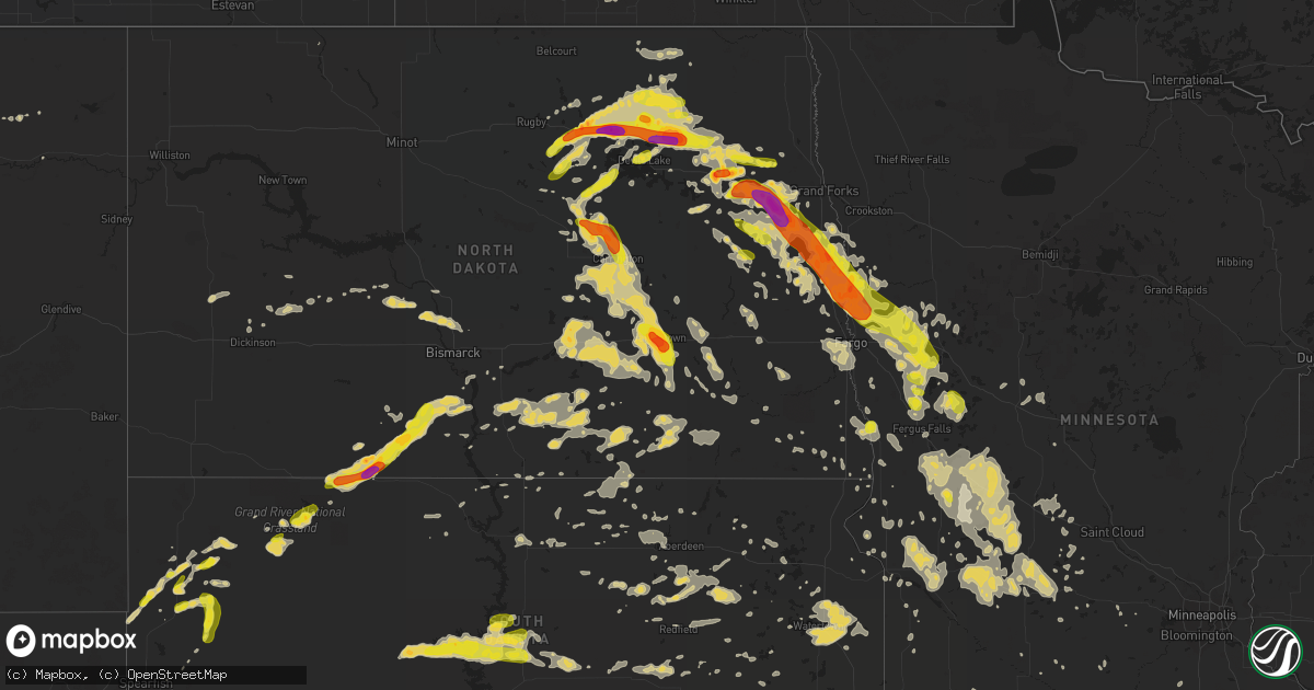
Hail Map on July 9, 2016
Get this storm
July 9 map
$229
one time, instant access
Download today. No call, no setup
Keep the $229
Bought the map and want the full workflow? Apply the entire $229 to a subscription within 7 days. None of it is wasted.
Every map, not just this one
This buys you this map. Subscription and you get every map we run, in the markets you choose from a few cities to whole states to nationwide. Plus real-time alerts the moment a storm fires.
Contact data
Name, contact info, occupancy, even credit band for addresses in the footprint. You go from where it hit to who to call.
Become the source they trust
Unlimited branding weather history reports on demand. You already have the documented answer ready for the property owner, and you are the one who showed up with it.
Property data and RoofTrace estimates
Pull up any address you have got, its value and the exact code rules for that jurisdiction, straight from One Click Code. Then RoofTrace estimates the squares, pitch, and roof value, priced the way you price.
States Impacted by Hail Map on July 9, 2016
Storm reports
Missouri
| Date | Description |
|---|---|
| 07/09/20164:54 PM CDT | Several oak tree limbs down appr. 3 inch in diameter across roadways mainly nne of edgar springs. |
| 07/09/20164:45 PM CDT | Thunderstorm winds downed a tree across the highway. |
| 07/09/201612:03 AM CDT | Severe thunderstorm wind gusts downed a large tree into a power line in the city of carterville. |
| 07/08/20167:50 PM CDT | Picture of hail near waynesville passed on via social media and amateur radio. |
New York
| Date | Description |
|---|---|
| 07/09/20162:40 PM CDT | Tree down on buell rd.... Time estimated |
| 07/09/20161:31 PM CDT | A few trees down...power lines down |
| 07/09/201611:15 AM CDT | Trees down...dock flipped over on raquette river...pontoon boats flipped over. |
Oklahoma
| Date | Description |
|---|---|
| 07/09/20166:50 PM CDT | A local report indicates 1.75 inch wind near 3 S CHEROKEE |
| 07/09/201610:30 AM CDT | Several trees and limbs downed by damaging winds. Power pole was snapped. Damage reported near n3750 road. |
| 07/09/20169:35 AM CDT | Trees knocked down and a carport flipped just south of shady creek cove on the east side of lake oolagah. Time estimated by radar. |
| 07/08/20167:05 PM CDT | A local report indicates 1.00 inch wind near CHEROKEE |
Georgia
| Date | Description |
|---|---|
| 07/09/20166:10 PM CDT | Multiple trees were blown down along highway 36 near stark. |
| 07/09/20166:00 PM CDT | Emergency manager reported 4 trees down. |
| 07/09/20165:45 PM CDT | Measured gust of 70 mph and quarter size hail. |
| 07/09/20165:42 PM CDT | Media shared photos of two trees down and a flipped irrigation pivot in turner county |
| 07/09/20165:00 PM CDT | Report of trees down and a blown transformer |
| 07/09/20165:00 PM CDT | Several trees were downed on highway 441. One tree temporarily blocked the highway. |
| 07/09/20163:18 PM CDT | The terrell county 911 center reported one tree down on cooper drive ne. |
| 07/09/20163:00 PM CDT | A traffic light was blown down at north avenue and gray highway. |
| 07/09/20162:59 PM CDT | A tree was blown down on sugarloaf circle...clipping the back of a home. |
| 07/09/20162:56 PM CDT | Trees were blown down on vineville avenue. |
| 07/09/20162:45 PM CDT | Multiple trees reported down just north of ideal. |
| 07/09/20162:30 PM CDT | Trees were reported down in northern schley county. |
| 07/09/20162:28 PM CDT | A tree was downed on hwy 137 near the county line. |
| 07/09/20162:27 PM CDT | Two trees were blown down on highway 42 near maynards mill rd. |
| 07/09/20162:12 PM CDT | Tree reported down near the intersection of rahn station rd at lewis rahn rd. Time estimated based on radar. |
| 07/09/20161:55 PM CDT | Many trees reported down across the town of clyo. Time estimated based on radar. |
| 07/09/20161:50 PM CDT | Many trees were reported down south of manchester near gilbert road. |
| 07/09/20161:30 PM CDT | Serveral trees were reported down along d street by the 911 center. |
| 07/09/20161:16 PM CDT | Tree reported down on powerlines near the intersection of burkhalter rd and hwy 67. Time estimated based on radar. |
| 07/09/20161:15 PM CDT | Several trees reported down along calhoun st by 911 center. |
| 07/09/20161:12 PM CDT | Quarter size hail reported at willow lake golf course |
| 07/09/20161:05 PM CDT | Serveral trees were reported down along d street by the 911 center. |
| 07/09/201612:30 PM CDT | One tree down along highway 315. |
Virginia
| Date | Description |
|---|---|
| 07/09/20164:00 PM CDT | A local report indicates 59 MPH wind near 1 SW QUANTICO |
Montana
| Date | Description |
|---|---|
| 07/09/20166:07 PM CDT | And pea sized hail. |
| 07/09/20165:56 PM CDT | A local report indicates 59 MPH wind near 7 NE DENTON |
| 07/09/20164:12 PM CDT | A local report indicates 60 MPH wind near 10 E WINNETT |
| 07/09/20164:01 PM CDT | A local report indicates 1.00 inch wind near 5 NNE WINNETT |
| 07/08/201611:30 PM CDT | Moderate sized tree uprooted from strong gusty winds. |
| 07/08/20168:50 PM CDT | A local report indicates 60 MPH wind near HINSDALE |
| 07/08/20168:24 PM CDT | Small trees bent over. Beaufort scale estimate of 55-63. |
Texas
| Date | Description |
|---|---|
| 07/09/20164:50 PM CDT | Bowie vfd reports estimated wind of 60 mph |
| 07/09/20164:36 PM CDT | 65 mph wind gust reported at moore/sandy lake in coppell. |
| 07/09/20164:33 PM CDT | 60 mph wind gust reported at dallas north tollway and nw hwy. |
| 07/09/20164:23 PM CDT | Fort worth/alliance asos reports gust of 51 kts |
| 07/09/20164:05 PM CDT | Large tree branches down at the intersection of collins rd and cleveland rd in denton. |
| 07/09/20162:36 PM CDT | Trained spotter reports 60 mph wind gust at hwy 11 and dewey in shouthern sherman. |
| 07/09/20162:05 PM CDT | Wind gust of 59 mph measured at frisco rd and texoma parkway. |
| 07/09/20162:05 PM CDT | 60 mph wind gust reported in denison |
| 07/09/20162:00 PM CDT | Significant tree damage. Damage to home from a fallen tree hwy 91 at shannon rd. |
| 07/09/201612:45 AM CDT | Trees knocked down by thunderstorm wind gusts. Time estimated by radar data and wind data from georgetown muni arpt |
| 07/08/20168:37 PM CDT | Small shed overturned and a section of fence down at the intersection of fm 1082 and cr 327 |
| 07/08/20167:13 PM CDT | Also reduced visibility due to flying dust |
Pennsylvania
| Date | Description |
|---|---|
| 07/09/20162:00 PM CDT | Trees down |
New Jersey
| Date | Description |
|---|---|
| 07/09/20165:48 PM CDT | Downed trees and wires |
| 07/09/20165:48 PM CDT | Numerous downed trees reported in fairton |
| 07/09/20165:45 PM CDT | Several downed trees in bridgeton |
| 07/09/20165:38 PM CDT | 25 softwood pine trees downed...some sheared off at 10 to 12 feet above ground level...on west park drive in the vicinity of route 49. |
| 07/09/20165:38 PM CDT | Trees and wires down in greenwich and hopewell twps |
| 07/09/20163:35 PM CDT | Several tree branches down on straughn mill road near i 295. Time estimated from radar and nearby reports |
| 07/08/20169:13 PM CDT | Some tree limbs down. Time estimated from radar. |
| 07/08/20168:57 PM CDT | Some trees down in trenton. Time estimated from radar. |
Alabama
| Date | Description |
|---|---|
| 07/09/20166:35 PM CDT | Report of tree down over power line in ashford |
| 07/09/20165:42 PM CDT | Tree down on viking dr and 20th ave |
| 07/09/20165:24 PM CDT | Tree down on hwy 69n near boldo |
| 07/09/20165:20 PM CDT | Trees and power lines down. Estimated 40 to 50 mile per hour winds. Street flooding reported in downtown jasper with town creek out of its banks. Street flooding with w |
| 07/09/20164:45 PM CDT | Reports trees down along hwy 189 n. Between kingston and elba. |
| 07/09/20164:45 PM CDT | Reports of trees down along hwy 427 |
| 07/09/20164:25 PM CDT | Trees and power lines down at yellow creek campground. |
| 07/09/20164:20 PM CDT | Power lines down on alabama ave and 16 ave |
| 07/09/20164:19 PM CDT | Power lines down on pike road |
| 07/09/20164:19 PM CDT | Power lines down on lown ave |
| 07/09/20164:18 PM CDT | *** 1 inj *** tree down on structure at 1841 st.charles street...1 injury reported |
| 07/09/20164:15 PM CDT | Large tree limbs/branches down greater than 2in |
| 07/09/20162:50 PM CDT | Tree down on dudleyville rd. Location and time estimated. |
| 07/09/20162:34 PM CDT | Gadsden asos reports tstm wind gust at 51kts and 42kts sustained |
| 07/09/20162:20 PM CDT | Power lines down at 835 egypt road...est wind speed 40-50mph |
| 07/09/20162:05 PM CDT | Three trees reported down... One along county road 19 and two along county road 38. Location approximate. Time estimated. |
| 07/09/20161:32 PM CDT | Tree fell onto car in phenix city. |
| 07/09/20161:23 PM CDT | Power line down on road near beauregard near intersection of lee county road 112 and lee county road 414. |
| 07/09/20161:15 PM CDT | Tree down on intersection of cr12 and cr29 est wind speed at 40-50mph |
| 07/09/20169:58 AM CDT | Trees and power lines down. Estimated 40 to 50 mile per hour winds. Street flooding reported in downtown jasper with town creek out of its banks. Street flooding with w |
| 07/08/20167:21 PM CDT | Two trees were knocked down along langston road near the water plant. Time estimated by radar. |
North Dakota
| Date | Description |
|---|---|
| 07/09/20166:50 PM CDT | 10 minute period of golf ball hail ended 700 pm. |
| 07/09/20166:46 PM CDT | Mostly quarter sized hail with several golf balls. |
| 07/09/20166:25 PM CDT | A local report indicates 1.00 inch wind near 4 SE HAMPDEN |
| 07/09/20166:21 PM CDT | Dime to quarter sized hail. |
| 07/09/20166:21 PM CDT | Dime to quarter sized hail. |
| 07/09/20166:20 PM CDT | Lots of dime sized hail. Some up to quater sized. |
| 07/09/20166:19 PM CDT | A local report indicates 1.00 inch wind near 3 S HAMPDEN |
| 07/09/20166:12 PM CDT | Wall cloud visible to southwest moving into grand forks county. |
| 07/09/20166:10 PM CDT | A local report indicates 1.25 inch wind near 6 W BROCKET |
| 07/09/20165:45 PM CDT | Mainly quarter to half dollar sized hail with some up to ping pong ball sized. Large hail occurred intermittently between 540 and 545 pm cdt. |
| 07/09/20165:25 PM CDT | Hail fell along the ramsey and cavalier county line. |
| 07/09/20165:05 PM CDT | Mainly quarter to ping pong ball sized hail. Some larger than a golfball. |
| 07/09/20164:55 PM CDT | Lots of quarter of half dollar sized hail. Hailed ended by 5 pm cdt. |
| 07/09/20164:28 PM CDT | Lots of 2 inch diameter covering the ground. Largest hailstones measured at 2.25 inch diameter. Report by trainer spotter/storm chaser. |
| 07/09/20164:20 PM CDT | A local report indicates 1.00 inch wind near DEVILS LAKE |
| 07/09/20163:49 PM CDT | A local report indicates 1.75 inch wind near LEEDS |
| 07/09/20163:25 PM CDT | A local report indicates 1.25 inch wind near 5 ESE FLORA |
| 07/09/20163:14 PM CDT | A local report indicates 1.00 inch wind near 10 N ESMOND |
| 07/09/20163:00 AM CDT | Branches down... Few trees down south in center. Time estimated from radar. Pea size hail. Delayed report from the morning of july 10... 2016. |
| 07/09/20161:50 AM CDT | Trees down and some barn damage. Time estimated from radar. Delayed report from early morning sunday... July 10th. |
| 07/09/20161:43 AM CDT | Peak wind measured at the rwis station on interstate 29 near the south dakota border. |
| 07/09/20161:28 AM CDT | Shingles blew off of an out building and wiindow panes blew out of a quonset. |
| 07/09/20161:28 AM CDT | 70 mph wind gusts estimated near exit 72 on interstate 94. |
| 07/09/20161:11 AM CDT | 63 mph wind gust measured by dickinson ndawn. |
| 07/09/20161:10 AM CDT | All times are central daylight. Kdik asos peak wind of the event was 76 mph. Based on asos one-minute data the severe thunderstorm wind started at 1251 am and continued |
| 07/09/20161:10 AM CDT | Report from the south side of dickinson of numerous trees snapped and others uprooted. A camper was flipped over. Person had a hand-held anemometer |
| 07/09/20161:04 AM CDT | A local report indicates 60 MPH wind near DICKINSON |
| 07/09/20161:00 AM CDT | Peak wind measured at a personal weather station. |
| 07/09/201612:31 AM CDT | Several large branches and limbs broken down in shelter belts along highway 46. |
| 07/09/201612:30 AM CDT | Several large tree branches and limbs broken down in shelter belts along highway 46. |
| 07/09/201612:10 AM CDT | Very heavy rains. Report posted via social media. |
| 07/08/201611:55 PM CDT | A local report indicates 1.00 inch wind near 4 N LITCHVILLE |
| 07/08/201611:05 PM CDT | Public report on the northwest side of jamestown relayed through the law enforcement center. |
| 07/08/201611:05 PM CDT | Report via social media. |
| 07/08/201610:05 PM CDT | Several lareg tree branches and limbs broken down around town. |
| 07/08/20169:50 PM CDT | Strong winds broke down numerous 1 to 3 inches branches. |
| 07/08/20169:50 PM CDT | Strong winds broke down numerous 1 to 3 inches branches. |
| 07/08/20169:45 PM CDT | Winds started around 945 and lasted through 10 pm. Pea size hail also reported |
| 07/08/20169:31 PM CDT | A local report indicates 1.00 inch wind near 5 N CARRINGTON |
| 07/08/20169:30 PM CDT | Winds gusted near 60 through 950 pm cdt |
| 07/08/20169:12 PM CDT | Winds to 55 miles and hour. |
| 07/08/20169:02 PM CDT | Arb observer reported hail between 902 pm cdt and 913 pm cdt. |
| 07/08/20168:57 PM CDT | A local report indicates 1.50 inch wind near 6 S ST. GERTRUDE |
| 07/08/20168:57 PM CDT | A local report indicates 60 MPH wind near 6 S ST. GERTRUDE |
| 07/08/20168:55 PM CDT | 40 mph winds also reported. |
| 07/08/20168:45 PM CDT | Damage to vehicle windshields has been observed. |
| 07/08/20168:38 PM CDT | Peak wind measured at a personal weather station. |
| 07/08/20168:35 PM CDT | Deputy reports severe winds impacting interstate 29 near mp114. |
| 07/08/20168:33 PM CDT | 50 mph winds also reported. |
| 07/08/20168:32 PM CDT | Hail of nickel sized or larger fell between 830 and 835 pm cdt. |
| 07/08/20168:30 PM CDT | A local report indicates 1.25 inch wind near BUXTON |
| 07/08/20168:30 PM CDT | Arb observer estimated hail occurred around 830 pm cdt |
| 07/08/20168:20 PM CDT | A local report indicates 1.50 inch wind near 4 NE BUXTON |
| 07/08/20168:15 PM CDT | Report from earlier this evening. |
| 07/08/20168:12 PM CDT | Lots of golf ball sized hail and very heavy rain and wind. |
| 07/08/20168:09 PM CDT | Numerous tennis ball size hail leading to heavy tree defoliage damage. |
| 07/08/20168:04 PM CDT | Picture and report posted via social media. |
| 07/08/20167:55 PM CDT | A local report indicates 2.00 inch wind near NORTHWOOD |
| 07/08/20167:50 PM CDT | A local report indicates 1.75 inch wind near NORTHWOOD |
| 07/08/20167:40 PM CDT | A local report indicates 1.00 inch wind near 3 E LARIMORE |
| 07/08/20167:30 PM CDT | A local report indicates 1.75 inch wind near LARIMORE |
| 07/08/20167:12 PM CDT | Wall cloud visible to southwest moving into grand forks county. |
Florida
| Date | Description |
|---|---|
| 07/09/20165:50 PM CDT | Reports of trees down in and around malone |
| 07/09/20165:50 PM CDT | Reports of trees down in and around bascom |
South Dakota
| Date | Description |
|---|---|
| 07/09/20166:58 PM CDT | A local report indicates 60 MPH wind near 3 SSE SORUM |
| 07/09/20166:40 PM CDT | A local report indicates 61 MPH wind near 13 SSW REVA |
| 07/09/20166:18 PM CDT | A local report indicates 60 MPH wind near 8 SE HOOVER |
| 07/09/20166:16 PM CDT | A local report indicates 70 MPH wind near HOOVER |
| 07/09/20166:14 PM CDT | A local report indicates 60 MPH wind near 10 SSE HOOVER |
| 07/09/20165:50 PM CDT | Also had pea size hail for a few minutes |
| 07/09/20165:25 PM CDT | A local report indicates 60 MPH wind near NEWELL |
| 07/09/20164:42 AM CDT | Radar estimated time. |
| 07/09/20161:43 AM CDT | A local report indicates 72 MPH wind near 4 NNW VICTOR |
| 07/09/20161:40 AM CDT | A local report indicates 62 MPH wind near 4 NNW VICTOR |
| 07/09/20161:36 AM CDT | A local report indicates 83 MPH wind near 2 ENE SISSETON |
| 07/08/201611:26 PM CDT | A local report indicates 1.00 inch wind near ONIDA |
| 07/08/201610:49 PM CDT | A local report indicates 1.25 inch wind near 14 WNW AGAR |
| 07/08/201610:40 PM CDT | A local report indicates 68 MPH wind near 2 N HERREID |
| 07/08/201610:08 PM CDT | Small trees snapped... Power pole down... Camper slid off pad. |
| 07/08/201610:00 PM CDT | A local report indicates 58 MPH wind near 13 NNW SANSARC |
| 07/08/20169:50 PM CDT | A local report indicates 61 MPH wind near 2 SSE MAHTO |
| 07/08/20169:30 PM CDT | A local report indicates 60 MPH wind near MCLAUGHLIN |
| 07/08/20169:19 PM CDT | Grand river raws. Gust time estimated by radar. |
| 07/08/20169:10 PM CDT | A local report indicates 65 MPH wind near 5 WNW MCLAUGHLIN |
| 07/08/20168:41 PM CDT | . |
| 07/08/20168:38 PM CDT | 6 foot long...3 inch diameter...tree branch broke off tree when outflow winds hit |
| 07/08/20168:00 PM CDT | . |
| 07/08/20167:55 PM CDT | A local report indicates 72 MPH wind near 3 ESE LEMMON |
| 07/08/20167:48 PM CDT | Time estimated from radar |
| 07/08/20167:35 PM CDT | A local report indicates 80 MPH wind near 8 SW SHADEHILL |
| 07/08/20167:20 PM CDT | A local report indicates 62 MPH wind near BISON |
Minnesota
| Date | Description |
|---|---|
| 07/09/20163:54 AM CDT | Large trees uprooted or snapped above ground level. Time estimated from radar. |
| 07/09/20162:14 AM CDT | Measured at the park rapids airport /kpkd/. |
| 07/09/20162:13 AM CDT | 50-60 mph... Radar estimated time. |
| 07/09/20161:55 AM CDT | Large tree uprooted. Picture on facebook. |
| 07/09/20161:40 AM CDT | Large trees broken down. |
| 07/09/20161:40 AM CDT | Hundreds of trees down with some house roofs damaged... Dozen or more power poles snapped... Sheds damaged. Radar estimated time. |
| 07/09/20161:30 AM CDT | Very strong wind as well. |
| 07/09/20161:10 AM CDT | Power poles down 1.5 miles east of town. |
| 07/09/20161:06 AM CDT | Tree limbs down. Picnic table flipped. |
| 07/09/20161:05 AM CDT | Five inch diameter tree limb severed. Bird feeder toppled. |
| 07/09/20161:00 AM CDT | Late report. Several big trees snapped off. |
| 07/09/201612:35 AM CDT | A couple of trees snapped in and around rockwood township...including the city of sebeka. At one farmstead... Several small calf hutches and one large super hutch were |
| 07/09/201612:30 AM CDT | Trees blown down and a barn roof was blown off. Peak winds estimated to 80 mph. |
| 07/09/201612:25 AM CDT | Large branches down. |
| 07/09/201612:25 AM CDT | Large branches down. |
| 07/09/201612:08 AM CDT | Large trees broken down. |
| 07/09/201612:06 AM CDT | Winds estimated at 60 to 70 mph. Large branches breaking down. Power outages. |
| 07/09/201612:06 AM CDT | Winds estimated at 60 to 70 mph. Large branches breaking down. Power outages. |
| 07/08/201611:55 PM CDT | Winds blew down displays at the phelps mill art festival. |
| 07/08/201611:52 PM CDT | Large tree branches broken down. Local power out. Report via social media. |
| 07/08/201611:35 PM CDT | Large maple tree broken down. |
| 07/08/201611:10 PM CDT | Large trees broken down near big comorant lake. Photo and report posted to social media. |
| 07/08/201611:06 PM CDT | A local report indicates 1.25 inch wind near AUDUBON |
| 07/08/201610:45 PM CDT | Report of two large branches broken off an oak tree. Posted via social media. |
| 07/08/201610:40 PM CDT | Driving rain and very strong winds estimated at 50 to 60 mph. Vehicle rocking. |
| 07/08/201610:20 PM CDT | Steel roofing material torn off of dog kennels. Steel doors caved in storage buildings. Construction trailer blown over and rolled. Trees broken down around town. Time |
| 07/08/20169:45 PM CDT | Lots of nickel to quarter sized hail and very strong winds. |
| 07/08/20169:25 PM CDT | Very strong winds bending trees. Power outage across area. |
Idaho
| Date | Description |
|---|---|
| 07/09/201612:05 AM CDT | Roberts arl site. |
| 07/08/201611:50 PM CDT | Kettle butte arl site. |
| 07/08/20169:01 PM CDT | A local report indicates 60 MPH wind near POCATELLO AIRPORT |
Colorado
| Date | Description |
|---|---|
| 07/08/20168:13 PM CDT | . |
| 07/08/20168:07 PM CDT | . |
Tennessee
| Date | Description |
|---|---|
| 07/09/201612:49 PM CDT | Tree down in driveway at 1119 madison creek road in goodlettsville |
Mississippi
| Date | Description |
|---|---|
| 07/09/20166:42 PM CDT | Sereral sheds blown down with one shed blown into a house on salum rd. Tree down in the pleasant grove community. |
| 07/09/20164:33 PM CDT | Off ms hwy 494... Accompanied by high winds. Reported via social media |
| 07/09/20164:10 PM CDT | Tree down across main street which brought down a power line. Trees were blown down and a shed had some damage. |
| 07/09/20163:55 PM CDT | Tree down across hwy 35. |
| 07/09/20163:07 PM CDT | Tree down aross old hwy 82. |
South Carolina
| Date | Description |
|---|---|
| 07/09/20166:54 PM CDT | Report of quarter size hail near intersection of sc 707 and bay rd. |
| 07/09/20166:45 PM CDT | Report of quarter size hail on east sweet briar trail. |
| 07/09/20166:45 PM CDT | Law enforcement reports quarter size hail. |
| 07/09/20166:40 PM CDT | Report of quarter size hail near intersection of bay rd and enterprise rd. Hail lasted for 10 minutes. |
| 07/09/20166:01 PM CDT | Reports of trees and powerlines down across andrews...on jones ave...park st...and s rosemary ave. Time estimated by radar. |
| 07/09/20165:30 PM CDT | A retired meteorologist reported golf ball size hail on debordieu boulevard. The hail lasted for 10 minutes. |
| 07/09/20164:35 PM CDT | Tree reported down on longridge rd near the intersection with wassamassaw lane. Time estimated based on radar. |
| 07/09/20163:02 PM CDT | Warning point reported a tree went through the top of a house at 70 block on crosstree drive north. |
| 07/09/20163:00 PM CDT | Trained spotter reports a tree down across may river rd just east of bolden rd |
| 07/09/20162:55 PM CDT | Tree reported down on hwy 17 about 2 miles north of gardens corner. Time estimated based on radar. |
| 07/09/20162:55 PM CDT | Tree reported down on trask pkwy at the intersection with hwy 17. Time estimated based on radar. |
| 07/09/20162:52 PM CDT | Facebook report shows multiple large oak trees down near the intersection of us hwy 278 and sc hwy 170 in okatie |
| 07/09/20162:47 PM CDT | Tree reported down near the intersection of bellinger hill rd with s okatie hwy. Time estimated based on radar. |
| 07/09/20162:42 PM CDT | Tree reported down near the intersection of heritage rd with grays hwy. Time estimated based on radar. |
| 07/09/20162:38 PM CDT | Tree reported down near the intersection of plantation dr and blue grouse pt. Time estimated based on radar. |
| 07/09/201610:19 AM CDT | Twitter report of multiple trees down...including one blocking maybank highway and on powerlines near the interesction of woodland shores rd on james island |
| 07/09/201610:19 AM CDT | Report of a large tree down across rushland landing rd on johns island...blocking access to the neighborhood |
| 07/09/201610:11 AM CDT | At least two large limbs down near the 500 block of stinson drive. Time estimated based on radar. |
| 07/09/201610:05 AM CDT | Numerous trees down...including one on a garage...in the carolina bay subdivision of west ashely |
Cities Impacted by Hail Map on July 9, 2016
- Fort Pierre, SD
- Brooten, MN
- Reva, SD
- Niagara, ND
- Michigan, ND
- Brocket, ND
- Dahlen, ND
- Lakota, ND
- Petersburg, ND
- Fordville, ND
- Buffalo, SD
- Alsen, ND
- Fayette, AL
- Bismarck, ND
- Center, ND
- Baldwin, ND
- Saint Lawrence, SD
- Lineville, AL
- Ridgeville, SC
- Summerville, SC
- Golden City, MO
- Reeds, MO
- Seymour, TX
- Hartshorn, MO
- Fort Stockton, TX
- Mountain Grove, MO
- Cherokee, OK
- Ellendale, ND
- Kathryn, ND
- Litchville, ND
- Horace, ND
- Clifford, ND
- Carrington, ND
- New Rockford, ND
- Calera, OK
- Cartwright, OK
- Buchanan, ND
- Solen, ND
- Grandin, ND
- Bellevue, TX
- Collinsville, TX
- Valley View, TX
- Gainesville, TX
- Battle Lake, MN
- Elbow Lake, MN
- Aliceville, AL
- Pelican Rapids, MN
- Audubon, MN
- Lake Park, MN
- Hawley, MN
- Jamestown, ND
- Northwood, ND
- Meadow, SD
- Lemmon, SD
- Clanton, AL
- Jemison, AL
- Arvilla, ND
- Emerado, ND
- Larimore, ND
- Burneyville, OK
- Clear Lake, SD
- Medina, ND
- Carson, ND
- Raleigh, ND
- Watauga, SD
- Shields, ND
- Keldron, SD
- Selfridge, ND
- Morristown, SD
- Churchs Ferry, ND
- Leeds, ND
- Lankin, ND
- Lawton, ND
- Penn, ND
- York, ND
- Devils Lake, ND
- Starkweather, ND
- Hampden, ND
- Rugby, ND
- Edmore, ND
- Crary, ND
- Munich, ND
- Esmond, ND
- Webster, ND
- Cando, ND
- Hitchcock, SD
- Wessington, SD
- Ypsilanti, ND
- Manchester, GA
- Zeeland, ND
- Wishek, ND
- Sunburg, MN
- Fitzgerald, GA
- Rochelle, GA
- Cloudcroft, NM
- Ashley, ND
- Lehr, ND
- Cody, WY
- Gordon, AL
- Donalsonville, GA
- Bascom, FL
- Laurel, MS
- Ellisville, MS
- Tappen, ND
- Edgar Springs, MO
- Eastman, GA
- Olney, TX
- Rosholt, SD
- Hendrum, MN
- Perley, MN
- Onida, SD
- Crawford, MS
- Starkville, MS
- Jackson, GA
- Opp, AL
- Kinston, AL
- Elba, AL
- Murdock, MN
- Benson, MN
- Argusville, ND
- Gardner, ND
- Arthur, ND
- Glenwood, GA
- Reynolds, GA
- Rupert, GA
- Butler, GA
- Edgeley, ND
- Pierre, SD
- Brooklet, GA
- Hollywood, SC
- Dallas, TX
- Woodworth, ND
- Pettibone, ND
- Thomaston, GA
- Thompson, ND
- Webster, SD
- Ringgold, TX
- Nocona, TX
- Bowie, TX
- Lapine, AL
- Mankato, MN
- Garfield, MN
- Newell, SD
- Belle Fourche, SD
- Bridgeport, TX
- Cochran, GA
- Gunter, TX
- Eutaw, AL
- Ridgeland, SC
- Wells, MN
- Kosciusko, MS
- Carthage, MS
- Coffeeville, MS
- New London, MN
- Belgrade, MN
- Kandiyohi, MN
- Spicer, MN
- Atwater, MN
- Myrtle Beach, SC
- Murrells Inlet, SC
- New Leipzig, ND
- Jasper, AL
- Everton, MO
- Ash Grove, MO
- Eden Valley, MN
- Watkins, MN
- Daviston, AL
- Cedar Hill, TX
- Grand Prairie, TX
- Pennock, MN
- Willmar, MN
- Waynesville, MO
- Napoleon, ND
- Kintyre, ND
- Delta, AL
- Merriman, NE
- Metter, GA
- Millville, NJ
- Bridgeton, NJ
- Shiloh, NJ
- Greenwich, NJ
- Cedarville, NJ
- Mcville, ND
- Linn Creek, MO
- Camdenton, MO
- Hollandale, MS
- Cohagen, MT
- Silverton, TX
- Wadley, AL
- Wedowee, AL
- Roanoke, AL
- Mauk, GA
- Buena Vista, GA
- Finley, ND
- Stanton, ND
- New Salem, ND
- Aberdeen, SD
- Westport, SD
- Ipswich, SD
- Northville, SD
- Mansfield, SD
- Notasulga, AL
- Bison, SD
- Uniontown, AL
- Macon, MS
- Shuqualak, MS
- Grandin, MO
- Rake, IA
- Frost, MN
- Buffalo Center, IA
- Clyde, TX
- Abilene, TX
- Decatur, MS
- Little Rock, MS
- Collins, GA
- Hazelton, ND
- Linton, ND
- Plains, GA
- Dawson, GA
- Smithville, GA
- Barnesville, MN
- Pitts, GA
- Springdale, AR
- Walker, MO
- Harwood, MO
- Nevada, MO
- Eureka, SD
- Hosmer, SD
- Gardner, KS
- Edgerton, KS
- Strandburg, SD
- South Shore, SD
- Castlewood, SD
- Goodwin, SD
- Kranzburg, SD
- Watertown, SD
- Hayti, SD
- Brusett, MT
- Winnett, MT
- Sand Springs, MT
- Mosby, MT
- Americus, GA
- Forsyth, GA
- Glenwood, MN
- Starbuck, MN
- Princeton, KS
- Morris, MN
- Correll, MN
- Appleton, MN
- Chokio, MN
- Ellendale, MN
- Frisco City, AL
- Beaverton, AL
- Grass Range, MT
- Oxford, MS
- Ashton, SD
- Cathay, ND
- Holt, FL
- Sawyerville, AL
- Ulen, MN
- Ogema, MN
- Callaway, MN
- Halstad, MN
- Lampasas, TX
- Alden, MN
- Greenville, MS
- Denison, TX
- Opelika, AL
- Lodgepole, SD
- Okeene, OK
- Ada, MN
- Twin Valley, MN
- Marietta, OK
- Thackerville, OK
- Colbert, OK
- Halliday, ND
- Clarks Grove, MN
- Hollandale, MN
- Geneva, MN
- Hartland, MN
- New Richland, MN
- Pekin, ND
- Harrold, SD
- Hillsboro, GA
- Hillsboro, ND
- Cleveland, ND
- Jud, ND
- Gackle, ND
- Streeter, ND
- Harvey, ND
- Wilton, ND
- Erhard, MN
- Elizabeth, MN
- Mead, OK
- Piedmont, AL
- Fort Yates, ND
- Nelson, MN
- Brandon, MN
- Alexandria, MN
- Miltona, MN
- Osakis, MN
- Lowry, MN
- Carlos, MN
- Evansville, MN
- Parkers Prairie, MN
- Farwell, MN
- Villard, MN
- Sauk Centre, MN
- Kensington, MN
- Hancock, NY
- Beardsley, MN
- Browns Valley, MN
- Georgiana, AL
- Greenville, AL
- El Dorado Springs, MO
- Johns Island, SC
- Mandan, ND
- Birmingham, AL
- Buxton, ND
- Cummings, ND
- Hatton, ND
- Hazlehurst, GA
- Ashby, MN
- Macon, GA
- Maddock, ND
- Oberon, ND
- Morristown, MN
- Mapleton, MN
- Cleveland, AL
- Oneonta, AL
- Hayden, AL
- Centrahoma, OK
- Tupelo, OK
- Webb City, MO
- Joplin, MO
- Okeechobee, FL
- Wakpala, SD
- McLaughlin, SD
- Inkster, ND
- Madrid, NY
- Grey Eagle, MN
- Melrose, MN
- Freeport, MN
- Cusseta, GA
- Flasher, ND
- Plato, MO
- Hobson, MT
- Prairie City, SD
- Milbank, SD
- Carthage, MO
- Jasper, MO
- Dadeville, AL
- Turton, SD
- Conde, SD
- Midland, SD
- Dupree, SD
- Foxhome, MN
- Breckenridge, MN
- Campbell, MN
- Norcross, MN
- Hoffman, MN
- Herman, MN
- Dalton, MN
- Wendell, MN
- Barrett, MN
- Waterville, NY
- Cassville, NY
- Bridgewater, NY
- Loring, MT
- Wolverton, MN
- Pingree, ND
- Sanger, TX
- Wagarville, AL
- Java, SD
- Winter Haven, FL
- Monroeville, AL
- Quitman, MS
- Clontarf, MN
- Lawrence, MS
- Lake, MS
- Conehatta, MS
- Taylor, ND
- Richardton, ND
- Scottsboro, AL
- Thompson, PA
- Pleasant Mount, PA
- Forest City, PA
- Herrick Center, PA
- Waymart, PA
- Honesdale, PA
- Union Dale, PA
- Meridian, MS
- Grapeland, TX
- Harwood, ND
- Felton, MN
- Georgetown, MN
- Borup, MN
- Fairmount, ND
- Estill, SC
- Mellette, SD
- Howe, TX
- Braddock, ND
- Alberta, AL
- Winthrop, NY
- North Lawrence, NY
- Brasher Falls, NY
- McKenzie, AL
- Wellsville, KS
- Catherine, AL
- Claxton, GA
- Altoona, AL
- Attalla, AL
- Gallant, AL
- Brooksville, MS
- Mooreton, ND
- Fort Mitchell, AL
- Dell Rapids, SD
- Rhine, GA
- Jacksonville, GA
- Gray, GA
- Georgetown, SC
- Holabird, SD
- Sulligent, AL
- Guin, AL
- Richville, MN
- Dent, MN
- Salem, MO
- Talladega, AL
- Alpine, AL
- Sycamore, GA
- Oriska, ND
- Phenix City, AL
- Columbus, GA
- Lobelville, TN
- Fort Benning, GA
- Paynesville, MN
- Leola, SD
- Forbes, ND
- Ramer, AL
- Madison, MN
- Ethel, MS
- Portland, ND
- Andrews, SC
- Cobbtown, GA
- Montpelier, ND
- Springfield, CO
- Bankston, AL
- Aberdeen, MS
- Prairie, MS
- Selby, SD
- Underwood, MN
- Muenster, TX
- Cresbard, SD
- Albany, MN
- Moultrie, GA
- Coolidge, GA
- Range, AL
- Brewton, AL
- Repton, AL
- Agar, SD
- Hayes, SD
- Eagle Butte, SD
- Gettysburg, SD
- Cedarbluff, MS
- Saint Jo, TX
- Swainsboro, GA
- Graceville, MN
- Winter Garden, FL
- Sharon, ND
- Forest City, IA
- Aneta, ND
- Shelly, MN
- Caledonia, ND
- Detroit Lakes, MN
- Hitterdal, MN
- Mayville, ND
- Blanchard, ND
- Reynolds, ND
- Galesburg, ND
- Hunter, ND
- Autaugaville, AL
- Enterprise, MS
- Henrietta, TX
- Holcomb, MS
- Elgin, ND
- Redwood Falls, MN
- Jacksboro, TX
- Alma, GA
- Reidsville, GA
- Miller, SD
- Wahpeton, ND
- Abbeville, AL
- Minnesota Lake, MN
- Saint Helena Island, SC
- Buhl, AL
- Fosters, AL
- Lenox, AL
- Castleberry, AL
- Jackson, PA
- Susquehanna, PA
- Lake Preston, SD
- Lena, MS
- Forest, MS
- Redfield, SD
- Samson, AL
- Safford, AL
- Lisbon, ND
- Shiloh, GA
- Woodland, GA
- Fredonia, ND
- Aline, OK
- Burlington, OK
- Dacoma, OK
- Carmen, OK
- Olivia, MN
- Auburn, AL
- Rothsay, MN
- North Bangor, NY
- Fessenden, ND
- Hampton, AR
- Celina, TX
- Evergreen, AL
- Broadview, NM
- Hereford, TX
- Lake Mary, FL
- Longwood, FL
- Lidgerwood, ND
- Okatie, SC
- Mill Creek, OK
- Burnet, TX
- Kerkhoven, MN
- Albert Lea, MN
- Collinsville, MS
- Pineland, SC
- Jermyn, PA
- Carbondale, PA
- Ochlocknee, GA
- Thomasville, GA
- Mathews, AL
- Palm Coast, FL
- Jay, FL
- Aubrey, TX
- Stockton, MO
- Bainbridge, GA
- Jacksons Gap, AL
- Gaylord, MN
- West Point, MS
- Spiritwood, ND
- Sanborn, ND
- Wimbledon, ND
- Calera, AL
- Trinity, TX
- Kulm, ND
- Rebecca, GA
- Maplesville, AL
- Grove Hill, AL
- Sheyenne, ND
- Roslyn, SD
- Pierpont, SD
- Groton, SD
- Stratford, SD
- Shorterville, AL
- Headland, AL
- Newville, AL
- Enderlin, ND
- Fingal, ND
- Page, ND
- Hope, ND
- Pittsview, AL
- Canby, MN
- Lonsdale, MN
- Montgomery, MN
- New Prague, MN
- Juliette, GA
- Hawkinsville, GA
- Fairfield, ND
- Venus, TX
- Ashland, AL
- Madill, OK
- Wadena, MN
- Verndale, MN
- Sebeka, MN
- Faulkton, SD
- Herreid, SD
- Hague, ND
- Lake Mills, IA
- Leland, IA
- Mescalero, NM
- Poplar Bluff, MO
- Holloway, MN
- Thompson, IA
- Lake Village, AR
- Hamilton, GA
- Walnut Grove, MS
- Fergus Falls, MN
- Columbus, MS
- Baxley, GA
- Lafayette, AL
- Brushton, NY
- Moira, NY
- Camp Hill, AL
- Sherman, TX
- Howard Lake, MN
- Manning, ND
- Gladstone, ND
- Springville, AL
- Remlap, AL
- Milburn, OK
- Vernon, AL
- West Winfield, NY
- Richland, GA
- Omaha, GA
- Bricelyn, MN
- Langdon, ND
- Winthrop, MN
- Whitesboro, TX
- Springfield, GA
- Guyton, GA
- Winfield, AL
- Robertsdale, AL
- Summersville, MO
- Cyrus, MN
- Clara City, MN
- Raymond, MN
- Donnelly, MN
- Grove City, MN
- Danvers, MN
- Montevideo, MN
- Maynard, MN
- Ocilla, GA
- Glyndon, MN
- Eminence, MO
- Whigham, GA
- Breckenridge, TX
- Graham, TX
- Graford, TX
- Wolford, ND
- Lewellen, NE
- Sonora, TX
- Claremont, SD
- Canton, NY
- Norwood, NY
- Potsdam, NY
- Culloden, GA
- Milan, GA
- Calvin, ND
- Wales, ND
- Cadwell, GA
- Andalusia, AL
- Winsted, MN
- Ellington, MO
- Roscoe, SD
- Grenada, MS
- Gore Springs, MS
- Hankinson, ND
- Boligee, AL
- Sykeston, ND
- Robinson, ND
- Strawn, TX
- Clinton, MN
- Ortonville, MN
- Corona, SD
- Glennville, GA
- Vale, SD
- Bellingham, MN
- Saint Michael, ND
- Pansey, AL
- Monticello, GA
- Salem, NJ
- Tower City, ND
- Swanquarter, NC
- Shellman, GA
- Cuthbert, GA
- Parrott, GA
- Watertown, MN
- Colfax, ND
- Winona, MS
- Duck Hill, MS
- Onaka, SD
- Mansfield, GA
- Vienna, GA
- Pinehurst, GA
- Climax, GA
- Milnor, ND
- Fullerton, ND
- Berlin, ND
- Hardeeville, SC
- Whatley, AL
- De Smet, SD
- Iroquois, SD
- Tulare, SD
- Seagoville, TX
- Centerville, KS
- Dickinson, ND
- Salem, AL
- Windermere, FL
- Orlando, FL
- Tuskegee, AL
- Merigold, MS
- Cooperstown, ND
- Darwin, MN
- Litchfield, MN
- Macks Creek, MO
- Deposit, NY
- Boaz, AL
- Fargo, ND
- Moorhead, MN
- West Fargo, ND
- Mapleton, ND
- Carrollton, MS
- Moffit, ND
- Hancock, MN
- Gallion, AL
- Coleman, GA
- Northwood, IA
- Sheldon, ND
- Leonard, ND
- Roach, MO
- Hope Hull, AL
- Montgomery, AL
- Hector, MN
- Newburg, MO
- Verona, ND
- Fort Ransom, ND
- Brentford, SD
- Warner, SD
- Rockham, SD
- Greensboro, AL
- Frankfort, SD
- Doland, SD
- Bunker, MO
- Ortley, SD
- Hazen, ND
- Beulah, ND
- Richmond, MN
- Rolla, MO
- Alto, TX
- Walsh, CO
- Andover, SD
- Pike Road, AL
- Philadelphia, MS
- Union, MS
- Ovett, MS
- Pine Mountain Valley, GA
- Nineveh, NY
- Harpursville, NY
- Malta, MT
- Edisto Island, SC
- Jakin, GA
- Luverne, AL
- Goshen, AL
- Charleston, MS
- Bluffton, SC
- Hilton Head Island, SC
- Camilla, GA
- Northport, AL
- Berry, AL
- Luverne, MN
- Blakely, GA
- Mound City, KS
- Statesboro, GA
- Dawson, MN
- Milan, MN
- Langford, SD
- Marion, ND
- Randolph, MS
- Port Royal, SC
- Beaufort, SC
- Windsor, NY
- Covington, GA
- Georgetown, TX
- Florence, TX
- Portal, GA
- Akron, AL
- Mathiston, MS
- Waseca, MN
- Ogdensburg, NY
- Lisbon, NY
- Gainesville, AL
- Wolsey, SD
- Jacksonboro, SC
- Adams Run, SC
- Delavan, MN
- Fultonham, NY
- Richmondville, NY
- West Fulton, NY
- Warnerville, NY
- Prompton, PA
- Colquitt, GA
- Emmons, MN
- Huron, SD
- Vergas, MN
- Brockton, MT
- Auburn University, AL
- Batesville, MS
- Red Lodge, MT
- Hamburg, AR
- Dumont, MN
- Fairdealing, MO
- Doniphan, MO
- Ottertail, MN
- Newington, GA
- Porcupine, SD
- Marks, MS
- Rochert, MN
- Ozona, TX
- Columbia, AL
- Vredenburgh, AL
- Franklin, AL
- Odessa, MN
- Big Stone City, SD
- Cascilla, MS
- Chateaugay, NY
- Colman, SD
- Chester, SD
- Kingston, OK
- Milton, FL
- Forest River, ND
- Gilby, ND
- Billingsley, AL
- Chester, GA
- Walton, NY
- Downsville, NY
- Clyo, GA
- Jackson, AL
- Saint Stephens, AL
- Chatom, AL
- Marion Junction, AL
- Good Thunder, MN
- Fort Gaines, GA
- Groveoak, AL
- Willow Lake, SD
- Bryant, SD
- Volga, SD
- Sylacauga, AL
- Weogufka, AL
- Rockford, AL
- Hay Springs, NE
- Franklin, MN
- West Chester, PA
- Chadds Ford, PA
- Wilmington, DE
- Rockland, DE
- Montchanin, DE
- Kennett Square, PA
- Paradise, TX
- Springtown, TX
- Henry, SD
- Garden City, SD
- Midville, GA
- Garfield, GA
- Twin City, GA
- Elysian, MN
- Prattville, AL
- Equinunk, PA
- Throckmorton, TX
- Gordon, GA
- Milledgeville, GA
- McIntyre, GA
- Jasper, MN
- Kansas City, KS
- Union Springs, AL
- Eupora, MS
- Mayhill, NM
- Parrish, AL
- Baker, FL
- Shaw, MS
- Leland, MS
- Indianola, MS
- Wann, OK
- Copan, OK
- Carpenter, SD
- Yale, SD
- Florala, AL
- Lockhart, AL
- Laurel Hill, FL
- Midlothian, TX
- Clarksdale, MS
- Tutwiler, MS
- Duncan, MS
- Lead, SD
- Miller, MO
- Mount Vernon, MO
- Pontotoc, MS
- Wheaton, MN
- Weir, MS
- Fairfax, MN
- Yatesville, GA
- McDavid, FL
- Minnewaukan, ND
- Pineview, GA
- Lamar, MO
- Owatonna, MN
- Mansfield, TX
- Idaho Falls, ID
- Roberts, ID
- Tennille, GA
- Yemassee, SC
- Kaufman, TX
- La Russell, MO
- Lockwood, MO
- Whitman, NE
- Water Valley, MS
- Banner, MS
- Long Lake, SD
- Lucan, MN
- Walnut Grove, MN
- South Greenfield, MO
- Newbern, AL
- Moncks Corner, SC
- Bowdle, SD
- Kingsley, PA
- Hop Bottom, PA
- Seabrook, SC
- Hermitage, AR
- Cannon Ball, ND
- Pemberton, MN
- Janesville, MN
- Valley City, ND
- Luverne, ND
- Altamonte Springs, FL
- Yazoo City, MS
- Cayuga, ND
- Joice, IA
- Staples, MN
- Kemp, TX
- Tuscaloosa, AL
- Ralph, AL
- East Branch, NY
- Allentown, PA
- Whitehall, PA
- Dothan, AL
- Kent, MN
- Bowdon, ND
- Kensal, ND
- Dawson, ND
- Dickey, ND
- Carrollton, AL
- Churubusco, NY
- Oakes, ND
- Fitzpatrick, AL
- Jones, AL
- Midland City, AL
- Milroy, MN
- Sunrise Beach, MO
- Centreville, AL
- Brent, AL
- Courtenay, ND
- Eagle Lake, MN
- Richland, MO
- Cushing, MN
- Pottsboro, TX
- Raymond, SD
- Desoto, TX
- Tyro, KS
- Caney, KS
- Verbena, AL
- Pollock, SD
- Eatonton, GA
- Aragon, GA
- Spring Hill, KS
- Rincon, GA
- Lakewood, PA
- Arthur, NE
- Mentone, AL
- Fort Payne, AL
- Valley Head, AL
- Locust Grove, GA
- Drew, MS
- Oakman, AL
- Fairfield, AL
- Sturgis, MS
- Van Alstyne, TX
- Kansas City, MO
- Parker, KS
- Waldorf, MN
- Easton, MN
- Rutland, SD
- Winona, MO
- Bruce, MS
- Hamilton, TX
- Cedar Bluff, AL
- Highmore, SD
- Bamberg, SC
- Stotts City, MO
- Louisville, GA
- Como, TX
- Oldham, SD
- Arlington, SD
- Ree Heights, SD
- Greenwood, MS
- Overbrook, OK
- Egeland, ND
- Nielsville, MN
- Adams, ND
- Climax, MN
- Fairdale, ND
- Porter, MN
- Clark, SD
- Forney, TX
- McCool, MS
- Ardmore, OK
- Sumner, MS
- Lewistown, MT
- Cairo, GA
- Woodson, TX
- Scurry, TX
- Laquey, MO
- Falcon, MO
- Lebanon, MO
- New York Mills, MN
- Sidney, NE
- Gurley, NE
- Pilot Point, TX
- Mccall, ID
- Summit, SD
- Abbeville, GA
- Osage Beach, MO
- Montreal, MO
- Cosmos, MN
- Dickinson Center, NY
- Eudora, AR
- Attapulgus, GA
- Hazel, SD
- Pritchett, CO