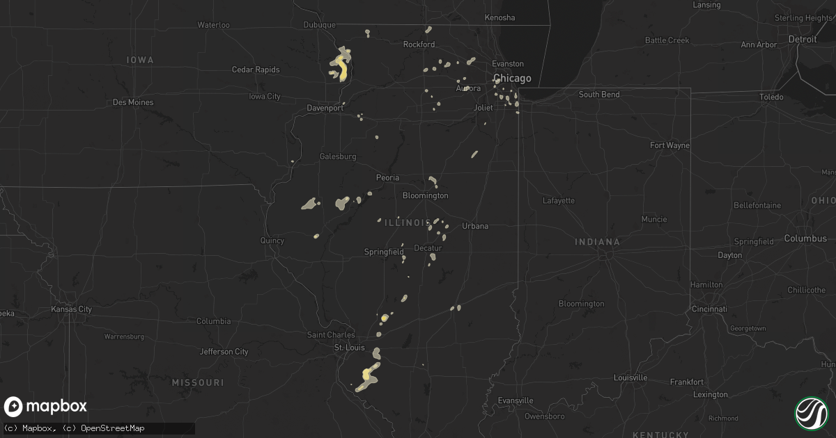
Hail Map in Illinois on July 5, 2023
Get this storm
July 5 map
$229
one time, instant access
Download today. No call, no setup
Keep the $229
Bought the map and want the full workflow? Apply the entire $229 to a subscription within 7 days. None of it is wasted.
Every map, not just this one
This buys you this map. Subscription and you get every map we run, in the markets you choose from a few cities to whole states to nationwide. Plus real-time alerts the moment a storm fires.
Contact data
Name, contact info, occupancy, even credit band for addresses in the footprint. You go from where it hit to who to call.
Become the source they trust
Unlimited branding weather history reports on demand. You already have the documented answer ready for the property owner, and you are the one who showed up with it.
Property data and RoofTrace estimates
Pull up any address you have got, its value and the exact code rules for that jurisdiction, straight from One Click Code. Then RoofTrace estimates the squares, pitch, and roof value, priced the way you price.
Storm reports in Illinois
Illinois
| Date | Description |
|---|---|
| 07/05/20236:54 PM CDT | Private weather station kilparkf15 recorded a 64 mph wind gust near park forest. |
| 07/05/20235:47 PM CDT | Numerous trees and powerlines down throughout the city. |
| 07/05/20235:34 PM CDT | Private weather station kilauror58 recorded a 60mph gust near north aurora. |
| 07/05/20235:20 PM CDT | Report of straight-line winds heading southbound on i-57 with trees bending and a couple snapped. Size and health of the trees unknown. |
| 07/05/20234:25 PM CDT | Estimated 50-60 mph. |
| 07/05/20233:09 PM CDT | Downed power poles. |
| 07/05/20232:56 PM CDT | Large tree uprooted landing on a building. |
| 07/05/20232:54 PM CDT | Multiple tree branches downed in morton grove near frontage road and i-94. Relayed via wgn-tv. Time estimated by radar. |
| 07/05/20232:45 PM CDT | Numerous large trees and tree limbs down at white oaks golf course. |
| 07/05/20232:42 PM CDT | Photos from twitter report show heavy tree damage in lewistown some trees/branches on houses. |
| 07/05/20232:24 PM CDT | Large branches downed. |
| 07/05/20231:59 PM CDT | Tree limbs down near highway 20 and elizabeth scales mound road. Relayed by law enforcement. Time estimated by radar. |
| 07/04/20237:15 PM CDT | 15 inch diameter tree downed near 182nd street and violet road. Relayed via amateur radio. Time estimated by radar. |
| 07/04/20237:05 PM CDT | Large branch down blocking 101st and torrence. |
All States Impacted by Hail Map on July 5, 2023
Cities Impacted by Hail Map on July 5, 2023
- Madison, WI
- Oregon, WI
- Verona, WI
- Stoughton, WI
- Cambridge, WI
- Edgerton, WI
- Longs, SC
- Little River, SC
- Wade, NC
- Fayetteville, NC
- Columbus, WI
- Waterloo, WI
- Norfork, AR
- Chester, AR
- Sainte Genevieve, MO
- Lake Mills, WI
- Canadian, TX
- Miami, TX
- Trinidad, CO
- Newport, AR
- Amagon, AR
- Weiner, AR
- Cash, AR
- Trinchera, CO
- Briscoe, TX
- Springer, NM
- Gould, OK
- Hollis, OK
- Vinson, OK
- Palmer Lake, CO
- Monument, CO
- Colorado Springs, CO
- Sedalia, CO
- Lake George, CO
- Atkinson, IL
- Bradford, IL
- Toulon, IL
- Lowndes, MO
- Greenville, MO
- Paw Paw, IL
- Buffalo, IL
- Vossburg, MS
- Paulding, MS
- Sycamore, IL
- Wappapello, MO
- Lena, IL
- De Land, IL
- Staunton, IL
- Edinburg, IL
- Amorita, OK
- Bryant, IA
- Preston, IA
- Miles, IA
- Clinton, IA
- Glasford, IL
- Canton, IL
- Manito, IL
- Grand Bay, AL
- Burlington, IA
- Placida, FL
- Clare, IL
- Malta, IL
- Geneva, AL
- Westville, FL
- Dalton City, IL
- Mt Zion, IL
- Decatur, IL
- Macomb, IL
- Sheridan, IL
- Leland, IL
- Teutopolis, IL
- Jefferson, WI
- Emmet, AR
- Lithia, FL
- Pocahontas, AR
- Imboden, AR
- Black Rock, AR
- Black, AL
- Bonifay, FL
- French Village, MO
- Bloomsdale, MO
- Warm Springs, AR
- Couch, MO
- Midlothian, IL
- Alsip, IL
- Blue Island, IL
- Posen, IL
- Robbins, IL
- Orlando, FL
- Kissimmee, FL
- Cuba, IL
- Lewistown, IL
- Colchester, IL
- Tennessee, IL
- Plymouth, IL
- Huntington, AR
- Mansfield, AR
- Effingham, IL
- Goose Lake, IA
- Charlotte, IA
- De Witt, IA
- Jacksonville, NC
- Defuniak Springs, FL
- Meddybemps, ME
- Chicago, IL
- Bay Minette, AL
- New Athens, IL
- Red Bud, IL
- Sarasota, FL
- Dix, IL
- Davenport, FL
- Farmington, MO
- Roosevelt, OK
- Lone Wolf, OK
- Farmer City, IL
- Belgium, WI
- Higgins, TX
- Savanna, IL
- Saint Mary, MO
- Sebring, FL
- Lorida, FL
- Hudson, IL
- Lexington, IL
- Gridley, IL
- Random Lake, WI
- Fredonia, WI
- Hector, AR
- Jerusalem, AR
- Booneville, AR
- Prairie Du Rocher, IL
- Evansville, IL
- Witt, IL
- Irving, IL
- Nokomis, IL
- Maple Hill, NC
- Shreveport, LA
- Lincoln, IL
- Rose Hill, NC
- Magnolia, NC
- El Dorado, AR
- Vancleave, MS
- Tavares, FL
- Astatula, FL
- Mascoutah, IL
- Bowling Green, FL
- Pachuta, MS
- Dennysville, ME
- Pembroke, ME
- New Smyrna Beach, FL
- Osteen, FL
- Geneva, FL
- Arkadelphia, AR
- Sorento, IL
- New Douglas, IL
- Conway, SC
- Watertown, WI
- Reeseville, WI
- Mammoth Spring, AR
- Atkins, AR
- Hardtner, KS
- Roscoe, IL
- Caledonia, IL
- South Beloit, IL
- Milton, FL
- Baker, FL
- Fort Knox, KY
- Vine Grove, KY
- Wing, AL
- Saline, LA
- Goldonna, LA
- Hobart, OK
- Mount Sterling, IL
- Sheboygan Falls, WI
- Plymouth, WI
- Oswego, IL
- Montgomery, IL
- Aurora, IL
- Bristol, IL
- Zolfo Springs, FL
- Monroe, LA
- Smithville, AR
- Powhatan, AR
- Highland, IL
- Marine, IL
- Freeburg, IL
- Violet Hill, AR
- Brockwell, AR
- Franklin, AR
- Groveland, FL
- Mascotte, FL
- Baileyville, ME
- Greenbush, MI
- Oscoda, MI
- De Queen, AR
- Mechanicsburg, IL
- Mount Auburn, IL
- Whitewater, WI
- Fort Atkinson, WI
- Trenton, IL
- Lebanon, IL
- Summerfield, IL
- New Baden, IL
- Elgin, IL
- Dundee, IL
- Carpentersville, IL
- Cisco, IL
- Argenta, IL
- Clinton, IL
- Dewitt, IL
- Eglin Afb, FL
- Marshall, WI
- Holt, FL
- Crestview, FL
- Piggott, AR
- Wimauma, FL
- Riverview, FL
- Moweaqua, IL
- McCrory, AR
- Bailey, CO
- Shawnee, CO
- Hoxie, AR
- Alicia, AR
- Walnut Ridge, AR
- Maroa, IL
- Winnabow, NC
- Elizabeth, AR
- Geneva, IL
- Williford, AR
- Ipava, IL
- Smithfield, IL
- Table Grove, IL
- Vermont, IL
- Sabula, IA
- Spragueville, IA
- Teeds Grove, IA
- Hanover, IL
- Bellevue, IA
- Virginia Beach, VA
- Chesapeake, VA
- Walshville, IL
- Rochelle, IL
- Esmond, IL
- Kingston, IL
- Perryville, MO
- Alton, MO
- Arcadia, FL
- Leslie, AR
- Clinton, AR
- Alhambra, IL
- Mountain View, AR
- Marissa, IL
- Lenzburg, IL
- Baldwin, IL
- Sparta, IL
- Five Points, AL
- Strong, AR
- Mcfarland, WI
- Louin, MS
- Sedgewickville, MO
- Towanda, IL
- Taylorville, IL
- Owaneco, IL
- Linden, NC
- Port Byron, IL
- Witts Springs, AR
- Woodland Park, CO
- Amity, AR
- Mena, AR
- Viola, AR
- Rector, AR
- Brooklyn, WI
- Crete, IL
- Strawberry, AR
- Interlachen, FL
- Saint Matthews, SC
- Miami, NM
- Marshall, AR
- Big Clifty, KY
- Cerro Gordo, IL
- Monticello, IL
- Milmine, IL
- West Monroe, LA
- Mount Judea, AR
- Butler, GA
- Reynolds, GA
- Ideal, GA
- Oak Ridge, MO
- Friedheim, MO
- Daisy, MO
- Millersville, MO
- Washington, LA
- Hampshire, IL
- Burlington, OK
- Everton, AR
- Western Grove, AR
- Fults, IL
- Ruston, LA
- Simsboro, LA
- Elkhart Lake, WI
- Sheboygan, WI
- New Orleans, LA
- Mount Erie, IL
- Donnellson, IL
- Hillsboro, IL
- Panama, IL
- Hillsdale, IL
- Roseboro, NC
- Mason City, IL
- Liverpool, IL
- Ponce De Leon, FL
- Mountain Home, AR
- Gassville, AR
- Poplar Bluff, MO
- Vredenburgh, AL
- Franklin, AL
- Johnson Creek, WI
- Fredericktown, MO
- Kiowa, KS
- Mamou, LA
- Elburn, IL
- Sugar Grove, IL
- Sullivan, WI
- Helenville, WI
- Earlville, IL
- Mclean, TX
- Shamrock, TX
- Clarendon, TX
- Wellington, TX
- Quail, TX
- Wagon Mound, NM
- Roy, NM
- Solano, NM
- Conchas Dam, NM
- West Memphis, AR
- Memphis, TN
- Lake Cormorant, MS
- Walls, MS
- Horn Lake, MS
- Germantown, TN
- Cordova, TN
- Southaven, MS
- Collierville, TN
- Olive Branch, MS
- Proctor, AR
- Byhalia, MS
- Hernando, MS
- Nesbit, MS
- Marion, AR
- Erick, OK
- Calhan, CO
- Yoder, CO
- Model, CO
- Quanah, TX
- Mosquero, NM
- Boone, CO
- La Junta, CO
- Childress, TX
- Paducah, TX
- Mangum, OK
- Dodson, TX
- Tucumcari, NM
- Rush, CO
- Olney Springs, CO
- Peetz, CO
- Sidney, NE
- Grady, NM
- Mcalister, NM
- Adrian, TX
- Hereford, TX
- Richfield, KS
- Johnson, KS
- Rolla, KS
- Hugoton, KS
- Rocky Ford, CO
- Manzanola, CO
- Ordway, CO
- Las Animas, CO
- Goodwell, OK
- Gruver, TX
- Cheraw, CO
- Sugar City, CO
- Crowley, CO
- Swink, CO
- Texico, NM
- San Jon, NM
- Broadview, NM
- Bovina, TX
- Friona, TX
- Farwell, TX
- Wildorado, TX
- Amarillo, TX
- Canyon, TX
- Vega, TX
- Guymon, OK
- Hooker, OK
- Wichita Falls, TX
- Henrietta, TX
- Holliday, TX
- Iowa Park, TX
- Sheppard Afb, TX
- Scotland, TX
- Springfield, CO
- Kim, CO
- Pritchett, CO
- Dimmitt, TX
- Muleshoe, TX
- Summerfield, TX
- Earth, TX
- Happy, TX
- Dekalb, IL
- Wilmington, IL
- Pine, CO
- Two Dot, MT
- Eldorado, OK
- Oak Brook, IL
- Batavia, IL
- Riverdale, IL
- Calumet City, IL
- Palos Park, IL
- Downsville, LA
- South Holland, IL
- Chicago Heights, IL
- Lansing, IL
- Munster, IN
- Toponas, CO
- Louisville, MS
- Larkspur, CO
- Rupert, GA
- Kempton, IL
- Cabery, IL
- Cullom, IL
- Oak Forest, IL
- Orland Park, IL
- Palos Heights, IL
- Markham, IL
- Crestwood, IL
- Harvey, IL
- Brooksville, MS
- Portia, AR
- Rainbow City, AL
- Gadsden, AL
- Ohatchee, AL
- Nahunta, GA
- Country Club Hills, IL
- Mobeetie, TX
- Riverside, IL
- La Grange Park, IL
- La Grange, IL
- Hines, IL
- Broadview, IL
- Forest Park, IL
- Lyons, IL
- Brookfield, IL
- Maywood, IL
- Lambert, MS
- Marks, MS
- Barrington, IL
- Burbank, IL
- Moorhead, MS
- Indianola, MS
- Inverness, MS
- Texola, OK
- Pampa, TX
- Industry, IL
- Greenwell Springs, LA
- Baker, LA
- Baton Rouge, LA
- Dyer, IN
- Mills, NM
- Burlington, ME
- Dieterich, IL
- Hinsdale, IL
- Willowbrook, IL
- Western Springs, IL
- Cameron, SC
- Shiloh, NC
- Camden, NC
- Townsend, GA
- Mickleton, NJ
- Swedesboro, NJ
- Gibbstown, NJ
- Brunswick, GA
- Darien, GA
- Electra, TX
- Slater, CO
- Craig, CO
- Hattieville, AR
- Eau Claire, MI
- Dowagiac, MI
- Seminary, MS
- Sumrall, MS
- Hattiesburg, MS
- Rossville, TN
- Coahoma, MS
- Calico Rock, AR
- Scotland, AR
- Franktown, CO
- Castle Rock, CO
- Gladstone, NM
- Melbourne, AR
- Waycross, GA
- Homewood, IL
- Hazel Crest, IL
- Okeechobee, FL
- Shawboro, NC
- Itta Bena, MS
- Canton, MS
- Yemassee, SC
- Green Pond, SC
- Hazelton, KS
- Moselle, MS
- Walsh, CO
- Campo, CO
- Boise City, OK
- Manter, KS
- Panhandle, TX
- Claude, TX
- Nazareth, TX
- Hart, TX
- Amherst, TX
- Fieldton, TX
- Olton, TX
- Littlefield, TX
- Springlake, TX
- Plainview, TX
- Kress, TX
- Hale Center, TX
- Tulia, TX
- Wheeler, TX
- Lockney, TX
- Abernathy, TX
- Petersburg, TX
- Floydada, TX
- Hardesty, OK
- Stratford, TX
- Keyes, OK
- Dalhart, TX
- Texhoma, OK
- Durham, OK
- Crawford, OK
- Cheyenne, OK
- Reydon, OK
- Sweetwater, OK
- Elk City, OK
- Hammon, OK
- Sayre, OK
- Leedey, OK
- Arnett, OK
- Palisade, NE
- Wauneta, NE
- Enders, NE
- Hayes Center, NE
- Gate, OK
- Perryton, TX
- Hillside, IL
- Walden, CO
- Follett, TX
- Shattuck, OK
- Watson, OK
- Potterville, MI
- New Raymer, CO
- Booker, TX
- Plains, KS
- Sublette, KS
- Lodgepole, NE
- Broken Bow, OK
- Clovis, NM
- Okemah, OK
- Bethel, OK
- Holly, CO
- Turpin, OK
- Coalgate, OK
- Centrahoma, OK
- Haworth, OK
- Ada, OK
- Stonewall, OK
- Stoneham, CO
- Padroni, CO
- Atoka, OK
- Coleman, OK
- Laverne, OK
- Ulysses, KS
- Weleetka, OK
- Liberal, KS
- Kismet, KS
- Minter City, MS
- Tupelo, OK
- Allen, OK
- Bridgeport, NJ
- Arlington, CO
- Charleston, MS
- Philipp, MS
- Courtland, MS
- Batesville, MS
- Willow, OK
- Wallace, NE
- Elsie, NE
- Lyon, MS
- Tutwiler, MS
- Madrid, NE
- Pearl, MS
- Florence, MS
- Wapanucka, OK
- Macon, MS
- Denham Springs, LA
- Tyrone, OK
- Doddsville, MS
- Ruleville, MS
- Holcomb, MS
- Ogden, AR
- Ashdown, AR
- Rohwer, AR
- Paden, OK
- Depew, OK
- Hartley, TX
- Wickes, AR
- Prague, OK
- Stigler, OK
- Byers, TX
- South Boardman, MI
- Stroud, OK
- Sparks, OK
- Beaver, OK
- Howe, OK
- Gillham, AR
- Randlett, OK
- Chandler, OK
- Mccurtain, OK
- Waurika, OK
- Temple, OK
- Hastings, OK
- Walters, OK
- Vance, MS
- Eufaula, OK
- Crawfordsville, AR
- Balko, OK
- Granite, OK


