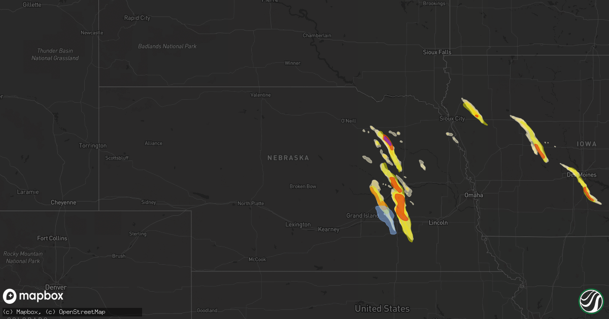
Hail Map in Nebraska on June 22, 2021
Get this storm
June 22 map
$229
one time, instant access
Download today. No call, no setup
Keep the $229
Bought the map and want the full workflow? Apply the entire $229 to a subscription within 7 days. None of it is wasted.
Every map, not just this one
This buys you this map. Subscription and you get every map we run, in the markets you choose from a few cities to whole states to nationwide. Plus real-time alerts the moment a storm fires.
Contact data
Name, contact info, occupancy, even credit band for addresses in the footprint. You go from where it hit to who to call.
Become the source they trust
Unlimited branding weather history reports on demand. You already have the documented answer ready for the property owner, and you are the one who showed up with it.
Property data and RoofTrace estimates
Pull up any address you have got, its value and the exact code rules for that jurisdiction, straight from One Click Code. Then RoofTrace estimates the squares, pitch, and roof value, priced the way you price.
Storm reports in Nebraska
Nebraska
| Date | Description |
|---|---|
| 06/22/20216:30 PM CDT | A local report indicates 1.00 inch wind near 8 W MADISON |
| 06/22/20216:19 PM CDT | A local report indicates 1.25 inch wind near NELIGH |
| 06/22/20216:00 PM CDT | A local report indicates 1.75 inch wind near 3 SE MEADOW GROVE |
| 06/22/20216:00 PM CDT | A local report indicates 1.25 inch wind near 4 SSE MEADOW GROVE |
| 06/22/20215:56 PM CDT | A local report indicates 1.25 inch wind near 4 SSE MEADOW GROVE |
| 06/22/20215:50 PM CDT | A local report indicates 1.75 inch wind near MEADOW GROVE |
| 06/22/20215:46 PM CDT | A local report indicates 1.00 inch wind near 3 SE MEADOW GROVE |
| 06/22/20215:44 PM CDT | A local report indicates 1.00 inch wind near MEADOW GROVE |
| 06/22/20215:32 PM CDT | A local report indicates 1.25 inch wind near 3 NNW MEADOW GROVE |
| 06/22/20215:20 PM CDT | A local report indicates 1.50 inch wind near 4 NNE TILDEN |
| 06/22/20215:00 PM CDT | Hail covered the ground. |
| 06/22/20215:28 AM CDT | At 1028 PM CDT, a severe thunderstorm was located over Bradshaw, or near York, moving southeast at 30 mph. HAZARD...Ping pong ball size hail and 60 mph wind gusts. SOURCE...Radar indicated. IMPACT...People and animals outdoors will be injured. Expect hail damage to roofs, siding, windows, and vehicles. Expect wind damage to roofs, siding, and trees. Locations impacted include... McCool Junction, Bradshaw, Grafton and Lushton. This includes Interstate 80 between mile markers 343 and 354. |
| 06/22/20214:49 AM CDT | At 949 PM CDT, a severe thunderstorm was located over Central City, or 24 miles northwest of York, moving south at 30 mph. HAZARD...Golf ball size hail and 60 mph wind gusts. SOURCE...Radar indicated. IMPACT...People and animals outdoors will be injured. Expect hail damage to roofs, siding, windows, and vehicles. Expect wind damage to roofs, siding, and trees. This severe thunderstorm will be near... Marquette around 1000 PM CDT.Other locations in the path of this severe thunderstorm includeAurora, Hampton, Bradshaw and Henderson.This includes Interstate 80 between mile markers 332 and 348. |
| 06/22/20214:28 AM CDT | At 928 PM CDT, a severe thunderstorm was located near Columbus, moving south at 30 mph. HAZARD...60 mph wind gusts and half dollar size hail. SOURCE...Radar indicated. IMPACT...Hail damage to vehicles is expected. Expect wind damage to roofs, siding, and trees. Locations impacted include... Shelby. |
| 06/22/20214:18 AM CDT | At 918 PM CDT, a severe thunderstorm was located over Friend, or 20 miles southeast of York, moving southeast at 25 mph. HAZARD...Ping pong ball size hail and 60 mph wind gusts. SOURCE...Radar indicated. IMPACT...People and animals outdoors will be injured. Expect hail damage to roofs, siding, windows, and vehicles. Expect wind damage to roofs, siding, and trees. This severe thunderstorm will be near... Western around 950 PM CDT.Other locations impacted by this severe thunderstorm include SwanCreek Reservoir Number 2, Swanton, 11 Miles West Of Wilber, Tobias,Willard Meyer Recreation Area and Swan Creek Wildlife ManagementArea. |
| 06/22/20214:12 AM CDT | At 912 PM CDT, a severe thunderstorm was located near Fullerton, or 35 miles northeast of Grand Island, moving south at 30 mph. HAZARD...Ping pong ball size hail and 60 mph wind gusts. SOURCE...Radar indicated. IMPACT...People and animals outdoors will be injured. Expect hail damage to roofs, siding, windows, and vehicles. Expect wind damage to roofs, siding, and trees. This severe thunderstorm will be near... Fullerton around 915 PM CDT.Other locations in the path of this severe thunderstorm includeArcher and Central City. |
| 06/22/20214:04 AM CDT | At 904 PM CDT, a severe thunderstorm was located 7 miles west of Beaver Crossing, or 13 miles southeast of York, moving south at 20 mph. HAZARD...Ping pong ball size hail and 60 mph wind gusts. SOURCE...Radar indicated. IMPACT...People and animals outdoors will be injured. Expect hail damage to roofs, siding, windows, and vehicles. Expect wind damage to roofs, siding, and trees. Locations impacted include... Exeter.This includes Interstate 80 between mile markers 358 and 365. |
| 06/22/20213:42 AM CDT | At 841 PM CDT, a severe thunderstorm was located over Waco, or near York, moving south at 30 mph. HAZARD...Golf ball size hail and 60 mph wind gusts. SOURCE...Radar indicated. IMPACT...People and animals outdoors will be injured. Expect hail damage to roofs, siding, windows, and vehicles. Expect wind damage to roofs, siding, and trees. This severe thunderstorm will be near... York around 845 PM CDT.Other locations in the path of this severe thunderstorm includeMcCool Junction.This includes Interstate 80 between mile markers 349 and 365. |
| 06/22/20212:59 AM CDT | At 758 PM CDT, severe thunderstorms were located along a line extending from 6 miles east of Clarks to Osceola to Shelby, moving south at 40 mph. HAZARD...Golf ball size hail and 70 mph wind gusts. SOURCE...Radar indicated. IMPACT...People and animals outdoors will be injured. Expect hail damage to roofs, siding, windows, and vehicles. Expect considerable tree damage. Wind damage is also likely to mobile homes, roofs, and outbuildings. Severe thunderstorms will be near... Stromsburg around 805 PM CDT. Polk, Benedict and Gresham around 815 PM CDT.Other locations in the path of these severe thunderstorms includeWaco, York and Bradshaw.This includes Interstate 80 between mile markers 342 and 365. |
| 06/22/20212:41 AM CDT | At 741 PM CDT, a severe thunderstorm was located near Monroe, or 12 miles west of Columbus, moving southeast at 25 mph. HAZARD...Two inch hail and 60 mph wind gusts. SOURCE...Radar indicated. IMPACT...People and animals outdoors will be injured. Expect hail damage to roofs, siding, windows, and vehicles. Expect wind damage to roofs, siding, and trees. This severe thunderstorm will be near... Duncan around 750 PM CDT.Other locations impacted by this severe thunderstorm include LakeOcaonee. |
| 06/22/20212:30 AM CDT | Large oak tree blown over near st. Josephs church in colon. |
| 06/22/20212:28 AM CDT | At 728 PM CDT, a severe thunderstorm was located near Genoa, or 17 miles west of Columbus, moving south at 35 mph. HAZARD...Ping pong ball size hail and 60 mph wind gusts. SOURCE...Radar indicated. IMPACT...People and animals outdoors will be injured. Expect hail damage to roofs, siding, windows, and vehicles. Expect wind damage to roofs, siding, and trees. This severe thunderstorm will be near... Silver Creek around 740 PM CDT.Other locations in the path of this severe thunderstorm includeOsceola and Shelby. |
| 06/22/20212:28 AM CDT | At 728 PM CDT, a severe thunderstorm was located near Monroe, or 16 miles west of Columbus, moving southeast at 20 mph. HAZARD...Two inch hail and 60 mph wind gusts. SOURCE...Radar indicated. IMPACT...People and animals outdoors will be injured. Expect hail damage to roofs, siding, windows, and vehicles. Expect wind damage to roofs, siding, and trees. This severe thunderstorm will remain over mainly rural areas of west central Platte County. |
| 06/22/20212:17 AM CDT | At 717 PM CDT, a severe thunderstorm was located over Monroe, or 14 miles west of Columbus, moving southeast at 25 mph. HAZARD...60 mph wind gusts and half dollar size hail. SOURCE...Radar indicated. IMPACT...Hail damage to vehicles is expected. Expect wind damage to roofs, siding, and trees. This severe thunderstorm will be near... Monroe around 720 PM CDT. Duncan around 740 PM CDT.Other locations impacted by this severe thunderstorm include LakeOcaonee. |
| 06/22/20211:59 AM CDT | At 659 PM CDT, a severe thunderstorm was located near Genoa, or 19 miles west of Columbus, moving southeast at 35 mph. HAZARD...60 mph wind gusts and half dollar size hail. SOURCE...Radar indicated. IMPACT...Hail damage to vehicles is expected. Expect wind damage to roofs, siding, and trees. This severe thunderstorm will remain over mainly rural areas of northeastern Nance and northeastern Merrick Counties. |
| 06/22/20211:58 AM CDT | At 658 PM CDT, a severe thunderstorm was located 5 miles southwest of Lindsay, or 25 miles northwest of Columbus, moving southeast at 20 mph. HAZARD...60 mph wind gusts and half dollar size hail. SOURCE...Radar indicated. IMPACT...Hail damage to vehicles is expected. Expect wind damage to roofs, siding, and trees. This severe thunderstorm will remain over mainly rural areas of northwestern Platte County. |
| 06/22/20211:53 AM CDT | At 653 PM CDT, a severe thunderstorm was located 10 miles east of Petersburg, or 25 miles west of Norfolk, moving southeast at 20 mph. HAZARD...60 mph wind gusts and half dollar size hail. SOURCE...Radar indicated. IMPACT...Hail damage to vehicles is expected. Expect wind damage to roofs, siding, and trees. Locations impacted include... Newman Grove. |
| 06/22/20211:28 AM CDT | At 627 PM CDT, a severe thunderstorm was located 8 miles west of Madison, or 17 miles southwest of Norfolk, moving southeast at 20 mph. HAZARD...Two inch hail and 60 mph wind gusts. SOURCE...Radar indicated. IMPACT...People and animals outdoors will be injured. Expect hail damage to roofs, siding, windows, and vehicles. Expect wind damage to roofs, siding, and trees. This severe thunderstorm will remain over mainly rural areas of south central Madison and northeastern Platte Counties, including the following locations... Cornlea and Humphrey. |
| 06/22/20211:26 AM CDT | At 625 PM CDT, a severe thunderstorm was located near Albion, or 35 miles southwest of Norfolk, moving southeast at 20 mph. HAZARD...60 mph wind gusts and half dollar size hail. SOURCE...Radar indicated. IMPACT...Hail damage to vehicles is expected. Expect wind damage to roofs, siding, and trees. Locations impacted include... St. Edward and Lindsay. |
| 06/22/20211:09 AM CDT | At 609 PM CDT, a severe thunderstorm was located over Neligh, or 31 miles west of Norfolk, moving southeast at 20 mph. HAZARD...60 mph wind gusts and half dollar size hail. SOURCE...Radar indicated. IMPACT...Hail damage to vehicles is expected. Expect wind damage to roofs, siding, and trees. This severe thunderstorm will be near... Oakdale around 620 PM CDT.Other locations in the path of this severe thunderstorm includeElgin. |
| 06/22/202112:42 AM CDT | At 542 PM CDT, a severe thunderstorm was located over Meadow Grove, or 17 miles west of Norfolk, moving south at 20 mph. HAZARD...Ping pong ball size hail. SOURCE...Radar indicated. IMPACT...People and animals outdoors will be injured. Expect damage to roofs, siding, windows, and vehicles. This severe thunderstorm will be near... Battle Creek around 555 PM CDT.Other locations in the path of this severe thunderstorm includeNewman Grove. |
| 06/22/202112:14 AM CDT | At 514 PM CDT, a severe thunderstorm was located 9 miles east of Neligh, or 24 miles northwest of Norfolk, moving southeast at 20 mph. HAZARD...Two inch hail and 60 mph wind gusts. SOURCE...Radar indicated. IMPACT...People and animals outdoors will be injured. Expect hail damage to roofs, siding, windows, and vehicles. Expect wind damage to roofs, siding, and trees. This severe thunderstorm will be near... Meadow Grove around 545 PM CDT. Battle Creek around 600 PM CDT.Other locations impacted by this severe thunderstorm include Tilden. |
| 06/21/202111:48 PM CDT | At 448 PM CDT, a severe thunderstorm was located 10 miles southwest of Plainview, or 33 miles northwest of Norfolk, moving southeast at 20 mph. HAZARD...Half dollar size hail. SOURCE...Radar indicated. IMPACT...Damage to vehicles is expected. This severe thunderstorm will remain over mainly rural areas of northwestern Madison, southwestern Pierce and northeastern Antelope Counties, including the following locations... Willow Creek State Recreation Area, Brunswick and Tilden. |
| 06/21/202110:27 PM CDT | Delayed report of roof damage and broken power poles. Time estimated from radar. |
| 06/21/202110:20 PM CDT | Relayed report from dispatch of a semi blown over at mile marker 339 on interstate 80... Which is 1 mile east of the hampton exit. No injuries reported. |
| 06/21/202110:18 PM CDT | Wind gusts estimated to be near 65 mph... Accompanied by pea size hail. |
| 06/21/202110:00 PM CDT | A local report indicates 1.00 inch wind near HORDVILLE |
| 06/21/20219:51 PM CDT | A local report indicates 1.00 inch wind near 5 SW CLARKS |
| 06/21/20219:50 PM CDT | A local report indicates 1.00 inch wind near HORDVILLE |
| 06/21/20219:20 PM CDT | Delayed public report of 2-4 inch diameter branches down on hwy 6. Relayed by wfo oax. |
| 06/21/20219:18 PM CDT | A local report indicates 1.25 inch wind near 3 W FRIEND |
| 06/21/20219:08 PM CDT | A local report indicates 1.25 inch wind near 6 E MCCOOL JUNCTION |
| 06/21/20218:43 PM CDT | A local report indicates 1.00 inch wind near WACO |
| 06/21/20218:34 PM CDT | A local report indicates 1.75 inch wind near 2 N BENEDICT |
| 06/21/20218:30 PM CDT | Quarter to ping pong ball size hail reported. |
| 06/21/20218:29 PM CDT | Report via facebook photos. |
| 06/21/20218:20 PM CDT | A local report indicates 1.00 inch wind near STROMSBURG |
| 06/21/20218:15 PM CDT | A local report indicates 1.50 inch wind near 2 E STROMSBURG |
| 06/21/20218:13 PM CDT | A local report indicates 1.25 inch wind near 3 N STROMSBURG |
| 06/21/20218:10 PM CDT | Ongoing on the south side of osceola. |
| 06/21/20218:09 PM CDT | Corrects previous hail report from osceola. Upon further review observer found some hail to at least 2 inch diameter on the north side of town. |
| 06/21/20218:08 PM CDT | A local report indicates 1.00 inch wind near 4 W OSCEOLA |
| 06/21/20217:48 PM CDT | A local report indicates 1.00 inch wind near 3 SSE MONROE |
| 06/21/20217:41 PM CDT | Hail lasted about 10 minutes. |
| 06/21/20217:34 PM CDT | A local report indicates 1.00 inch wind near 5 W MONROE |
| 06/21/20217:30 PM CDT | Reports of tree branches downed in genoa. Wind gust reports received were around 75 mph. Report of a shed damaged east of genoa... Exact location unknown at this time. |
| 06/21/20217:30 PM CDT | Quarter size hail falling at this time. Wind gusts estimated to be 50-60 mph at times. |
| 06/21/20217:28 PM CDT | Widespread tree damage. Power lines blown down. Shed destroyed. Semi blown over. |
| 06/21/20217:28 PM CDT | Hail could be even bigger. Ongoing. |
| 06/21/20217:10 PM CDT | Also 50-60 mph winds estimated. |
All States Impacted by Hail Map on June 22, 2021
Cities Impacted by Hail Map on June 22, 2021
- Waukee, IA
- Grimes, IA
- Windsor Heights, IA
- Clive, IA
- Dallas Center, IA
- Urbandale, IA
- Bagley, IA
- Jefferson, IA
- Kahoka, MO
- Osceola, NE
- Shelby, NE
- Friend, NE
- Gresham, NE
- Genoa, NE
- Cordova, NE
- Saint Edward, NE
- Beaver Crossing, NE
- Monroe, NE
- Silver Creek, NE
- Exeter, NE
- Stromsburg, NE
- Columbus, NE
- Waco, NE
- Benedict, NE
- York, NE
- Urbana, IA
- Coggon, IA
- Walker, IA
- Central City, IA
- Center Point, IA
- Vinton, IA
- Mount Sterling, IA
- Lake City, IA
- Yale, IA
- Lanesboro, IA
- Scranton, IA
- Nemaha, IA
- Lohrville, IA
- Fonda, IA
- Lytton, IA
- Glidden, IA
- Rockwell City, IA
- Churdan, IA
- Auburn, IA
- Sac City, IA
- Clarkson, NE
- Howells, NE
- Tilden, NE
- Brunswick, NE
- Humphrey, NE
- Meadow Grove, NE
- Madison, NE
- Neligh, NE
- Lindsay, NE
- Cantril, IA
- Hedrick, IA
- Libertyville, IA
- Bonaparte, IA
- Ollie, IA
- Packwood, IA
- Farmington, IA
- Luray, MO
- Martinsburg, IA
- Keosauqua, IA
- Arbela, MO
- Birmingham, IA
- Sigourney, IA
- Douds, IA
- Hayesville, IA
- Batavia, IA
- Ottumwa, IA
- Fairfield, IA
- Selma, IA
- Eldon, IA
- Utica, NE
- Platte Center, NE
- McCool Junction, NE
- Newman Grove, NE
- Albion, NE
- Fullerton, NE
- Palmer, NE
- Central City, NE
- Petersburg, NE
- Cedar Rapids, NE
- Hampton, NE
- Clarks, NE
- Bradshaw, NE
- Marquette, NE
- Henderson, NE
- Polk, NE
- Hordville, NE
- Belgrade, NE
- Carlisle, IA
- Norwalk, IA
- Indianola, IA
- Des Moines, IA
- Fairmont, NE
- Pierce, NE
- Pierson, IA
- Correctionville, IA
- Remsen, IA
- Le Mars, IA
- Kingsley, IA
- Webster, IA
- North English, IA
- South English, IA
- Harper, IA
- Mount Auburn, IA
- Brandon, IA
- Alburnett, IA
- Oakdale, NE
- Clearwater, NE
- Battle Creek, NE
- Washta, IA
- Winnebago, NE
- Lacona, IA
- Ackworth, IA
- Milo, IA
- Rising City, NE
- Bellwood, NE
- David City, NE
- Fellsmere, FL
- East Bridgewater, MA
- Bridgewater, MA
- Johnston, IA
- West Des Moines, IA
- Gladbrook, IA
- Traer, IA
- Ewing, NE
- Ulysses, NE
- Surprise, NE
- Plainview, NE
- Chariton, IA
- Macy, NE
- Grenville, NM
- Orchard, NE
- Beaman, IA
- Minburn, IA
- Hanson, MA
- Halifax, MA
- Satellite Beach, FL
- Melbourne, FL
- Merritt Island, FL
- Patrick Afb, FL
- Reinbeck, IA
- Milligan, NE
- Ralston, IA
- Royal, NE
- Independence, IA
- Jesup, IA
- Carroll, IA
- Jamaica, IA
- Coon Rapids, IA
- Grand View, ID
- Jordan Valley, OR
- Rowley, IA
- La Porte City, IA
- Osmond, NE
- Norfolk, NE
- Sloan, IA
- Onawa, IA
- Wolbach, NE
- Beach Haven, NJ
- Grand Junction, IA
- Palm Bay, FL
- Early, IA
- Delta, IA
- What Cheer, IA
- Russell, IA
- Aurora, NE
- Grafton, NE
- Ryan, IA
- Cushing, IA
- Battle Creek, IA
- Holstein, IA
- Tobias, NE
- Duncan, NE
- Stockport, IA
- Milton, IA


