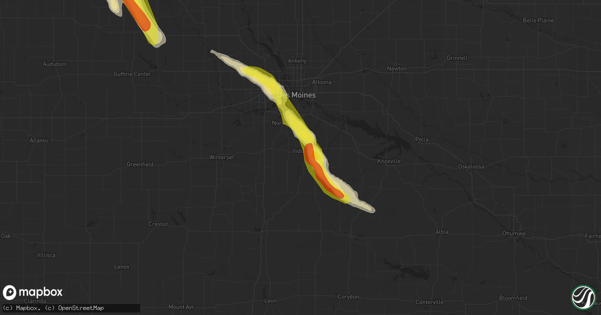
Hail Map in Indianola, IA on June 22, 2021
Get this storm
June 22 map
$229
one time, instant access
Download today. No call, no setup
Keep the $229
Bought the map and want the full workflow? Apply the entire $229 to a subscription within 7 days. None of it is wasted.
Every map, not just this one
This buys you this map. Subscription and you get every map we run, in the markets you choose from a few cities to whole states to nationwide. Plus real-time alerts the moment a storm fires.
Contact data
Name, contact info, occupancy, even credit band for addresses in the footprint. You go from where it hit to who to call.
Become the source they trust
Unlimited branding weather history reports on demand. You already have the documented answer ready for the property owner, and you are the one who showed up with it.
Property data and RoofTrace estimates
Pull up any address you have got, its value and the exact code rules for that jurisdiction, straight from One Click Code. Then RoofTrace estimates the squares, pitch, and roof value, priced the way you price.
Storm reports in Indianola, IA
Indianola, IA
| Date | Description |
|---|---|
| 06/22/20216:31 PM CDT | Report from mping: ping pong ball |
| 06/22/20216:30 PM CDT | Report from mping: quarter |
| 06/22/20216:25 PM CDT | 1.5 inch hail still along highway 92 east of indianola. Occurrence time estimated by radar. |
| 06/22/20216:22 PM CDT | Quarter to ping pong ball sized hail in indianola. |
| 06/22/20216:05 PM CDT | Road is completely covered with dime to quarter size hail along g24 highway near highway 65/69 intersection north of indianola. Time estimated by radar. |
All States Impacted by Hail Map on June 22, 2021
All Cities Impacted by Hail Map on June 22, 2021
- Waukee, IA
- Grimes, IA
- Windsor Heights, IA
- Clive, IA
- Dallas Center, IA
- Urbandale, IA
- Bagley, IA
- Jefferson, IA
- Kahoka, MO
- Osceola, NE
- Shelby, NE
- Friend, NE
- Gresham, NE
- Genoa, NE
- Cordova, NE
- Saint Edward, NE
- Beaver Crossing, NE
- Monroe, NE
- Silver Creek, NE
- Exeter, NE
- Stromsburg, NE
- Columbus, NE
- Waco, NE
- Benedict, NE
- York, NE
- Urbana, IA
- Coggon, IA
- Walker, IA
- Central City, IA
- Center Point, IA
- Vinton, IA
- Mount Sterling, IA
- Lake City, IA
- Yale, IA
- Lanesboro, IA
- Scranton, IA
- Nemaha, IA
- Lohrville, IA
- Fonda, IA
- Lytton, IA
- Glidden, IA
- Rockwell City, IA
- Churdan, IA
- Auburn, IA
- Sac City, IA
- Clarkson, NE
- Howells, NE
- Tilden, NE
- Brunswick, NE
- Humphrey, NE
- Meadow Grove, NE
- Madison, NE
- Neligh, NE
- Lindsay, NE
- Cantril, IA
- Hedrick, IA
- Libertyville, IA
- Bonaparte, IA
- Ollie, IA
- Packwood, IA
- Farmington, IA
- Luray, MO
- Martinsburg, IA
- Keosauqua, IA
- Arbela, MO
- Birmingham, IA
- Sigourney, IA
- Douds, IA
- Hayesville, IA
- Batavia, IA
- Ottumwa, IA
- Fairfield, IA
- Selma, IA
- Eldon, IA
- Utica, NE
- Platte Center, NE
- McCool Junction, NE
- Newman Grove, NE
- Albion, NE
- Fullerton, NE
- Palmer, NE
- Central City, NE
- Petersburg, NE
- Cedar Rapids, NE
- Hampton, NE
- Clarks, NE
- Bradshaw, NE
- Marquette, NE
- Henderson, NE
- Polk, NE
- Hordville, NE
- Belgrade, NE
- Carlisle, IA
- Norwalk, IA
- Indianola, IA
- Des Moines, IA
- Fairmont, NE
- Pierce, NE
- Pierson, IA
- Correctionville, IA
- Remsen, IA
- Le Mars, IA
- Kingsley, IA
- Webster, IA
- North English, IA
- South English, IA
- Harper, IA
- Mount Auburn, IA
- Brandon, IA
- Alburnett, IA
- Oakdale, NE
- Clearwater, NE
- Battle Creek, NE
- Washta, IA
- Winnebago, NE
- Lacona, IA
- Ackworth, IA
- Milo, IA
- Rising City, NE
- Bellwood, NE
- David City, NE
- Fellsmere, FL
- East Bridgewater, MA
- Bridgewater, MA
- Johnston, IA
- West Des Moines, IA
- Gladbrook, IA
- Traer, IA
- Ewing, NE
- Ulysses, NE
- Surprise, NE
- Plainview, NE
- Chariton, IA
- Macy, NE
- Grenville, NM
- Orchard, NE
- Beaman, IA
- Minburn, IA
- Hanson, MA
- Halifax, MA
- Satellite Beach, FL
- Melbourne, FL
- Merritt Island, FL
- Patrick Afb, FL
- Reinbeck, IA
- Milligan, NE
- Ralston, IA
- Royal, NE
- Independence, IA
- Jesup, IA
- Carroll, IA
- Jamaica, IA
- Coon Rapids, IA
- Grand View, ID
- Jordan Valley, OR
- Rowley, IA
- La Porte City, IA
- Osmond, NE
- Norfolk, NE
- Sloan, IA
- Onawa, IA
- Wolbach, NE
- Beach Haven, NJ
- Grand Junction, IA
- Palm Bay, FL
- Early, IA
- Delta, IA
- What Cheer, IA
- Russell, IA
- Aurora, NE
- Grafton, NE
- Ryan, IA
- Cushing, IA
- Battle Creek, IA
- Holstein, IA
- Tobias, NE
- Duncan, NE
- Stockport, IA
- Milton, IA


