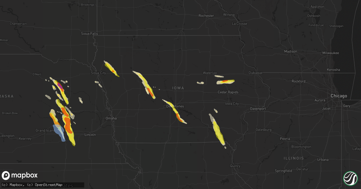
Hail Map in Iowa on June 22, 2021
Get this storm
June 22 map
$229
one time, instant access
Download today. No call, no setup
Keep the $229
Bought the map and want the full workflow? Apply the entire $229 to a subscription within 7 days. None of it is wasted.
Every map, not just this one
This buys you this map. Subscription and you get every map we run, in the markets you choose from a few cities to whole states to nationwide. Plus real-time alerts the moment a storm fires.
Contact data
Name, contact info, occupancy, even credit band for addresses in the footprint. You go from where it hit to who to call.
Become the source they trust
Unlimited branding weather history reports on demand. You already have the documented answer ready for the property owner, and you are the one who showed up with it.
Property data and RoofTrace estimates
Pull up any address you have got, its value and the exact code rules for that jurisdiction, straight from One Click Code. Then RoofTrace estimates the squares, pitch, and roof value, priced the way you price.
Storm reports in Iowa
Iowa
| Date | Description |
|---|---|
| 06/22/20216:55 PM CDT | Public report of half dollar size hail. |
| 06/22/20216:50 PM CDT | A local report indicates 1.25 inch wind near 3 N BAGLEY |
| 06/22/20216:48 PM CDT | Trained spotter report of golf ball size hail. |
| 06/22/20216:40 PM CDT | Report via social media. Time estimated by radar. |
| 06/22/20216:38 PM CDT | Significant hail damage to crops. |
| 06/22/20216:34 PM CDT | Hail of at least quarter size reported. Crops severely damaged by hail. |
| 06/22/20216:31 PM CDT | Report from mping: ping pong ball |
| 06/22/20216:30 PM CDT | Report from mping: quarter |
| 06/22/20216:25 PM CDT | 1.5 inch hail still along highway 92 east of indianola. Occurrence time estimated by radar. |
| 06/22/20216:23 PM CDT | 1 foot diameter tree snapped. |
| 06/22/20216:22 PM CDT | Quarter to ping pong ball sized hail in indianola. |
| 06/22/20216:20 PM CDT | Large playset displaced and siding to house damaged by wind driven hail. Winds estimated 60 mph. |
| 06/22/20216:05 PM CDT | Road is completely covered with dime to quarter size hail along g24 highway near highway 65/69 intersection north of indianola. Time estimated by radar. |
| 06/22/20215:59 PM CDT | Also winds estimated at 55 mph. |
| 06/22/20215:58 PM CDT | Report from mping: quarter |
| 06/22/20215:55 PM CDT | Large tree down along with a utility pole. |
| 06/22/20215:48 PM CDT | Report from mping: ping pong ball |
| 06/22/20215:46 PM CDT | A local report indicates 1.00 inch wind near 1 SSW WINDSOR HEIGHTS |
| 06/22/20215:45 PM CDT | A local report indicates 1.50 inch wind near LYTTON |
| 06/22/20215:45 PM CDT | Lots of quarter sized hail. |
| 06/22/20215:42 PM CDT | Report from mping: quarter |
| 06/22/20215:40 PM CDT | A local report indicates 1.75 inch wind near WALKER |
| 06/22/20215:39 PM CDT | A local report indicates 1.00 inch wind near 1 WNW URBANDALE |
| 06/22/20215:39 PM CDT | Mostly pea to nickel size hail with a few quarters mixed in. |
| 06/22/20215:39 PM CDT | Delayed report from dmx. Damaged/flattened corn half mile to one mile south of town. Leaves ripped off trees with small limbs down. Time estimated from radar. |
| 06/22/20215:38 PM CDT | Personal weather station. |
| 06/22/20215:38 PM CDT | Report via social media. |
| 06/22/20215:35 PM CDT | Report from mping: quarter |
| 06/22/20215:33 PM CDT | Time estimated by radar. |
| 06/22/20215:30 PM CDT | Report from mping: quarter |
| 06/22/20215:30 PM CDT | A local report indicates 1.00 inch wind near 1 S JOHNSTON |
| 06/22/20215:28 PM CDT | A local report indicates 60 MPH wind near WAUKEE |
| 06/22/20215:25 PM CDT | Nickel to quarter size hail. |
| 06/22/20211:57 AM CDT | At 657 PM CDT, a severe thunderstorm was located over Abingdon, or 11 miles northwest of Fairfield, moving south at 40 mph. HAZARD...60 mph wind gusts and half dollar size hail. SOURCE...Radar indicated. IMPACT...Hail damage to vehicles is expected. Expect wind damage to roofs, siding, and trees. This severe thunderstorm will be near... Maharishi Vedic City around 705 PM CDT. Batavia around 710 PM CDT. Libertyville around 715 PM CDT. |
| 06/22/20211:52 AM CDT | At 652 PM CDT, a severe thunderstorm was located near Correctionville, or 21 miles northwest of Ida Grove, moving southeast at 30 mph. HAZARD...Golf ball size hail and 60 mph wind gusts. SOURCE...Radar indicated. IMPACT...People and animals outdoors will be injured. Expect hail damage to roofs, siding, windows, and vehicles. Expect wind damage to roofs, siding, and trees. This severe thunderstorm will be near... Correctionville and Anthon around 700 PM CDT. Cushing around 705 PM CDT. Ida Grove, Battle Creek and Danbury around 730 PM CDT. |
| 06/22/20211:49 AM CDT | At 649 PM CDT, a severe thunderstorm was located 9 miles southwest of Jefferson, moving southeast at 40 mph. HAZARD...Golf ball size hail and 60 mph wind gusts. SOURCE...Radar indicated. IMPACT...People and animals outdoors will be injured. Expect hail damage to roofs, siding, windows, and vehicles. Expect wind damage to roofs, siding, and trees. This severe thunderstorm will be near... Lake Panorama around 705 PM CDT.Other locations in the path of this severe thunderstorm includePanora. |
| 06/22/20211:33 AM CDT | At 633 PM CDT, a severe thunderstorm was located near Glidden, or 11 miles west of Jefferson, moving southeast at 40 mph. HAZARD...60 mph wind gusts and quarter size hail. SOURCE...Radar indicated. IMPACT...Hail damage to vehicles is expected. Expect wind damage to roofs, siding, and trees. This severe thunderstorm will remain over mainly rural areas of southwestern Greene and southeastern Carroll Counties, including the following locations... Ralston and Scranton. |
| 06/22/20211:30 AM CDT | At 629 PM CDT, a severe thunderstorm was located 9 miles southeast of Indianola, moving southeast at 45 mph. HAZARD...Ping pong ball size hail and 60 mph wind gusts. SOURCE...Radar indicated. IMPACT...People and animals outdoors will be injured. Expect hail damage to roofs, siding, windows, and vehicles. Expect wind damage to roofs, siding, and trees. Locations impacted include... Chariton. |
| 06/22/20211:24 AM CDT | At 624 PM CDT, a severe thunderstorm was located near Kingsley, or 14 miles southeast of Le Mars, moving southeast at 30 mph. HAZARD...Golf ball size hail and 60 mph wind gusts. SOURCE...Radar indicated. IMPACT...People and animals outdoors will be injured. Expect hail damage to roofs, siding, windows, and vehicles. Expect wind damage to roofs, siding, and trees. This severe thunderstorm will be near... Pierson around 640 PM CDT. Washta around 645 PM CDT. Correctionville around 650 PM CDT. |
| 06/22/20211:09 AM CDT | At 609 PM CDT, a severe thunderstorm was located near Remsen, or 8 miles southeast of Le Mars, moving southeast at 30 mph. HAZARD...60 mph wind gusts and half dollar size hail. SOURCE...Radar indicated. IMPACT...Hail damage to vehicles is expected. Expect wind damage to roofs, siding, and trees. This severe thunderstorm will be near... Kingsley around 625 PM CDT. Pierson around 635 PM CDT. Correctionville, Quimby and Washta around 645 PM CDT.Other locations impacted by this severe thunderstorm include Oyens. |
| 06/22/20211:09 AM CDT | At 609 PM CDT, a severe thunderstorm was located 11 miles west of Gowrie, or 13 miles southeast of Rockwell City, moving southeast at 45 mph. HAZARD...60 mph wind gusts and quarter size hail. SOURCE...Radar indicated. IMPACT...Hail damage to vehicles is expected. Expect wind damage to roofs, siding, and trees. This severe thunderstorm will be near... Jefferson around 625 PM CDT.Other locations in the path of this severe thunderstorm includeOgden. |
| 06/22/202112:58 AM CDT | At 558 PM CDT, a severe thunderstorm was located over Norwalk, moving southeast at 35 mph. HAZARD...60 mph wind gusts and quarter size hail. SOURCE...Radar indicated. IMPACT...Hail damage to vehicles is expected. Expect wind damage to roofs, siding, and trees. This severe thunderstorm will be near... Indianola around 610 PM CDT. |
| 06/22/202112:50 AM CDT | At 550 PM CDT, a severe thunderstorm was located 7 miles northwest of Lake City, or 9 miles southeast of Sac City, moving southeast at 35 mph. HAZARD...60 mph wind gusts and quarter size hail. SOURCE...Radar indicated. IMPACT...Hail damage to vehicles is expected. Expect wind damage to roofs, siding, and trees. This severe thunderstorm will be near... Lake City around 605 PM CDT. |
| 06/22/202112:30 AM CDT | At 530 PM CDT, a severe thunderstorm was located over Urbandale, moving southeast at 25 mph. HAZARD...Ping pong ball size hail and 60 mph wind gusts. SOURCE...Radar indicated. Trained spotters have already reported at least quarter size hail with this storm. IMPACT...People and animals outdoors will be injured. Expect hail damage to roofs, siding, windows, and vehicles. Expect wind damage to roofs, siding, and trees. This severe thunderstorm will be near... Valley West Mall around 535 PM CDT. Windsor Heights, Saylorville and Merle Hay Mall around 540 PM CDT. Drake Stadium And Knapp Center around 545 PM CDT. Des Moines, Ankeny, Iowa Events Center, Principal Park and Des Moines Int'l Airport around 550 PM CDT.Other locations in the path of this severe thunderstorm includeNorwalk, Southridge Mall, Iowa State Fairgrounds, Pleasant Hill andCarlisle.This includes the following highways... Interstate 35 between mile markers 70 and 72, and between milemarkers 87 and 88. Interstate 80 between mile markers 122 and 139. Interstate 235 between mile markers 1 and 14. |
| 06/22/202112:27 AM CDT | At 526 PM CDT, a severe thunderstorm was located over Urbana, or 7 miles northeast of Vinton, moving east at 50 mph. HAZARD...Quarter size hail. SOURCE...Radar indicated. IMPACT...Damage to vehicles is expected. This severe thunderstorm will be near... Center Point and Walker around 535 PM CDT. Troy Mills around 540 PM CDT. Paris around 545 PM CDT.Other locations in the path of this severe thunderstorm includeCentral City, Coggon, Ryan and Prairieburg. |
| 06/22/202112:22 AM CDT | At 522 PM CDT, a severe thunderstorm was located near Sac City, moving southeast at 40 mph. HAZARD...60 mph wind gusts and quarter size hail. SOURCE...Radar indicated. IMPACT...Hail damage to vehicles is expected. Expect wind damage to roofs, siding, and trees. Locations impacted include... Rockwell City. |
| 06/21/202111:59 PM CDT | At 459 PM CDT, a severe thunderstorm was located near Dallas Center, or near Perry, moving east at 25 mph. HAZARD...60 mph wind gusts and quarter size hail. SOURCE...Radar indicated. IMPACT...Hail damage to vehicles is expected. Expect wind damage to roofs, siding, and trees. This severe thunderstorm will be near... Dallas Center around 505 PM CDT.Other locations in the path of this severe thunderstorm includeWaukee, Granger, Urbandale, Saylorville Lake, Grimes, Polk City, WestDes Moines, Johnston and Clive.This includes Interstate 80 between mile markers 120 and 122, andbetween mile markers 125 and 128. |
| 06/21/20217:40 PM CDT | Occurring right now. 36 mph wind gust. |
| 06/21/20217:25 PM CDT | Also high winds. |
| 06/21/20217:16 PM CDT | Pea to quarter sized hail; lasted for 10 to 15 minutes. |
| 06/21/20217:02 PM CDT | Dime to quarter hail fell for two to three minutes. |
All States Impacted by Hail Map on June 22, 2021
Cities Impacted by Hail Map on June 22, 2021
- Waukee, IA
- Grimes, IA
- Windsor Heights, IA
- Clive, IA
- Dallas Center, IA
- Urbandale, IA
- Bagley, IA
- Jefferson, IA
- Kahoka, MO
- Osceola, NE
- Shelby, NE
- Friend, NE
- Gresham, NE
- Genoa, NE
- Cordova, NE
- Saint Edward, NE
- Beaver Crossing, NE
- Monroe, NE
- Silver Creek, NE
- Exeter, NE
- Stromsburg, NE
- Columbus, NE
- Waco, NE
- Benedict, NE
- York, NE
- Urbana, IA
- Coggon, IA
- Walker, IA
- Central City, IA
- Center Point, IA
- Vinton, IA
- Mount Sterling, IA
- Lake City, IA
- Yale, IA
- Lanesboro, IA
- Scranton, IA
- Nemaha, IA
- Lohrville, IA
- Fonda, IA
- Lytton, IA
- Glidden, IA
- Rockwell City, IA
- Churdan, IA
- Auburn, IA
- Sac City, IA
- Clarkson, NE
- Howells, NE
- Tilden, NE
- Brunswick, NE
- Humphrey, NE
- Meadow Grove, NE
- Madison, NE
- Neligh, NE
- Lindsay, NE
- Cantril, IA
- Hedrick, IA
- Libertyville, IA
- Bonaparte, IA
- Ollie, IA
- Packwood, IA
- Farmington, IA
- Luray, MO
- Martinsburg, IA
- Keosauqua, IA
- Arbela, MO
- Birmingham, IA
- Sigourney, IA
- Douds, IA
- Hayesville, IA
- Batavia, IA
- Ottumwa, IA
- Fairfield, IA
- Selma, IA
- Eldon, IA
- Utica, NE
- Platte Center, NE
- McCool Junction, NE
- Newman Grove, NE
- Albion, NE
- Fullerton, NE
- Palmer, NE
- Central City, NE
- Petersburg, NE
- Cedar Rapids, NE
- Hampton, NE
- Clarks, NE
- Bradshaw, NE
- Marquette, NE
- Henderson, NE
- Polk, NE
- Hordville, NE
- Belgrade, NE
- Carlisle, IA
- Norwalk, IA
- Indianola, IA
- Des Moines, IA
- Fairmont, NE
- Pierce, NE
- Pierson, IA
- Correctionville, IA
- Remsen, IA
- Le Mars, IA
- Kingsley, IA
- Webster, IA
- North English, IA
- South English, IA
- Harper, IA
- Mount Auburn, IA
- Brandon, IA
- Alburnett, IA
- Oakdale, NE
- Clearwater, NE
- Battle Creek, NE
- Washta, IA
- Winnebago, NE
- Lacona, IA
- Ackworth, IA
- Milo, IA
- Rising City, NE
- Bellwood, NE
- David City, NE
- Fellsmere, FL
- East Bridgewater, MA
- Bridgewater, MA
- Johnston, IA
- West Des Moines, IA
- Gladbrook, IA
- Traer, IA
- Ewing, NE
- Ulysses, NE
- Surprise, NE
- Plainview, NE
- Chariton, IA
- Macy, NE
- Grenville, NM
- Orchard, NE
- Beaman, IA
- Minburn, IA
- Hanson, MA
- Halifax, MA
- Satellite Beach, FL
- Melbourne, FL
- Merritt Island, FL
- Patrick Afb, FL
- Reinbeck, IA
- Milligan, NE
- Ralston, IA
- Royal, NE
- Independence, IA
- Jesup, IA
- Carroll, IA
- Jamaica, IA
- Coon Rapids, IA
- Grand View, ID
- Jordan Valley, OR
- Rowley, IA
- La Porte City, IA
- Osmond, NE
- Norfolk, NE
- Sloan, IA
- Onawa, IA
- Wolbach, NE
- Beach Haven, NJ
- Grand Junction, IA
- Palm Bay, FL
- Early, IA
- Delta, IA
- What Cheer, IA
- Russell, IA
- Aurora, NE
- Grafton, NE
- Ryan, IA
- Cushing, IA
- Battle Creek, IA
- Holstein, IA
- Tobias, NE
- Duncan, NE
- Stockport, IA
- Milton, IA


