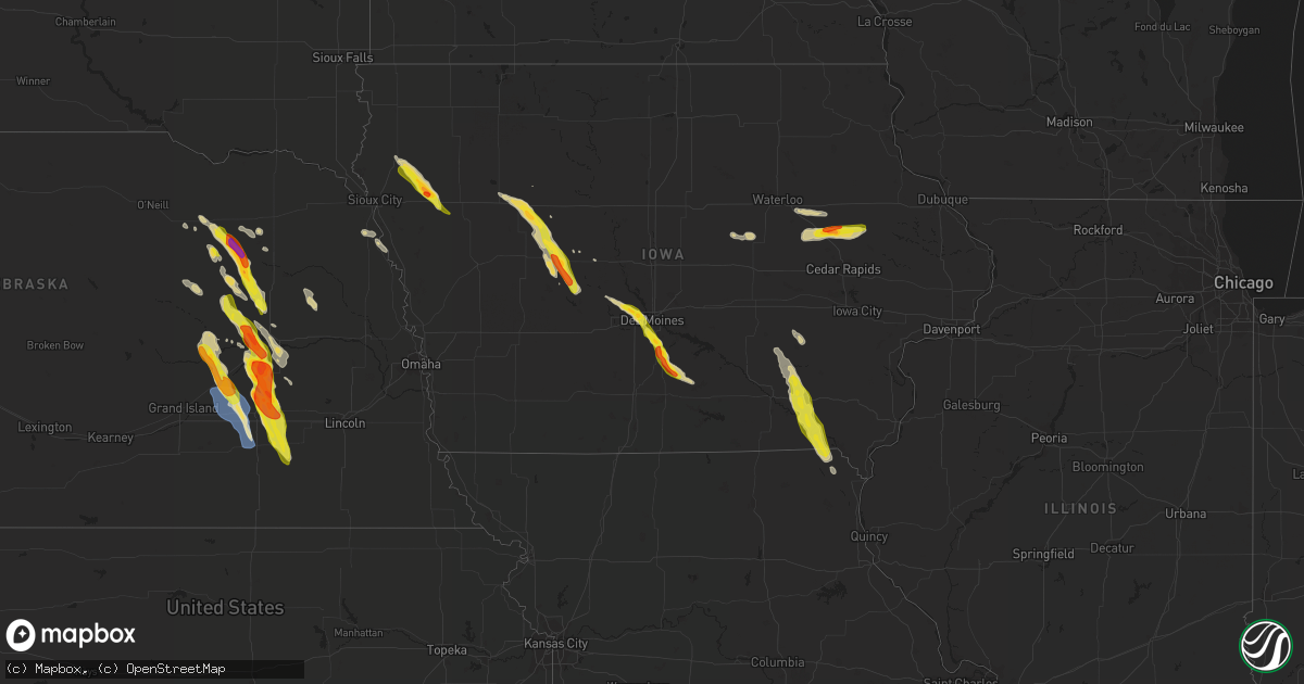
Hail Map on June 22, 2021
Get this storm
June 22 map
$229
one time, instant access
Download today. No call, no setup
Keep the $229
Bought the map and want the full workflow? Apply the entire $229 to a subscription within 7 days. None of it is wasted.
Every map, not just this one
This buys you this map. Subscription and you get every map we run, in the markets you choose from a few cities to whole states to nationwide. Plus real-time alerts the moment a storm fires.
Contact data
Name, contact info, occupancy, even credit band for addresses in the footprint. You go from where it hit to who to call.
Become the source they trust
Unlimited branding weather history reports on demand. You already have the documented answer ready for the property owner, and you are the one who showed up with it.
Property data and RoofTrace estimates
Pull up any address you have got, its value and the exact code rules for that jurisdiction, straight from One Click Code. Then RoofTrace estimates the squares, pitch, and roof value, priced the way you price.
States Impacted by Hail Map on June 22, 2021
Storm reports
Florida
| Date | Description |
|---|---|
| 06/22/20211:40 PM CDT | Small tree down over cr 310. Time of event estimated with radar. |
| 06/22/20211:25 PM CDT | Damage to small storage sheds near the 2100 block of state road 16 near st augustine. Time estimated from radar. |
| 06/22/20211:20 PM CDT | A tree fell onto a residence causing significant property damage. Time of damage estimated from radar imagery. |
| 06/22/202112:40 PM CDT | A large tree uprooted and fell on top of a house on west 69th street in jacksonville. No injuries. Time estimated by radar. |
| 06/22/202111:58 AM CDT | Trees down near old lawtey rd. Time of event estimated with radar. |
| 06/22/20217:22 AM CDT | At 1222 PM EDT, a severe thunderstorm was located over Lake Butler, moving east at 20 mph. HAZARD...60 mph wind gusts. SOURCE...Radar indicated. IMPACT...Expect damage to roofs, siding, and trees. Locations impacted include... Starke, Lake Butler, Raiford, Beasley, New River, Lawtey, Ellerbee and Johnstown. |
| 06/22/20212:16 AM CDT | At 716 AM EDT, a severe thunderstorm was located 19 miles south of Greensboro, or 20 miles southeast of Blountstown, moving east at 45 mph. HAZARD...60 mph wind gusts. SOURCE...Radar indicated. IMPACT...Expect damage to roofs, siding, and trees. Locations impacted include... Telogia, Lake Talquin, Bloxham, Brown House, Fort Braden and Clio. |
| 06/21/202111:09 PM CDT | At 408 PM EDT, a severe thunderstorm was located over Sanford, moving northeast at 15 mph. HAZARD...60 mph wind gusts and nickel size hail. SOURCE...Radar indicated. IMPACT...Expect damage to roofs, siding, and trees. Locations impacted include... Deltona, Sanford, Orange City, DeBary and Osteen. |
| 06/21/20218:46 PM CDT | At 146 PM EDT, a severe thunderstorm was located over Bardin, or near Palatka, moving east at 25 mph. HAZARD...60 mph wind gusts. SOURCE...Radar indicated. IMPACT...Expect damage to roofs, siding, and trees. Locations impacted include... Bostwick, Federal Point, Bardin and Carraway. |
Rhode Island
| Date | Description |
|---|---|
| 06/22/20211:15 PM CDT | Large branch down on beach ave near west shore road. |
Virginia
| Date | Description |
|---|---|
| 06/22/20211:45 PM CDT | Trees downed along shell rd. Time is radar estimated. |
| 06/22/20211:30 PM CDT | A couple of trees downed along ballard st. |
| 06/21/20219:23 PM CDT | At 222 PM EDT, severe thunderstorms were located along a line extending from 6 miles northeast of Bavon to near Grand View to near Christopher Newport University, moving east at 40 mph. HAZARD...60 mph wind gusts. SOURCE...Radar indicated. IMPACT...Expect damage to trees and powerlines. Severe thunderstorms will be near, Grand View around 235 PM EDT. Cape Charles, Ocean View, Old Dominion University, Cheriton, Bay View and Ghent around 240 PM EDT. Norfolk International and Norview around 245 PM EDT. Virginia Wesleyan University and Norfolk around 250 PM EDT. Virginia Beach around 300 PM EDT.Other locations impacted by these severe thunderstorms includeCapeville, South Norfolk, Kiptopeke State Park, Rudee Heights,Carrollton, Portlock, Princess Anne Plaza, Sigma, Eastville andHilton Village. |
Iowa
| Date | Description |
|---|---|
| 06/22/20216:55 PM CDT | Public report of half dollar size hail. |
| 06/22/20216:50 PM CDT | A local report indicates 1.25 inch wind near 3 N BAGLEY |
| 06/22/20216:48 PM CDT | Trained spotter report of golf ball size hail. |
| 06/22/20216:40 PM CDT | Report via social media. Time estimated by radar. |
| 06/22/20216:38 PM CDT | Significant hail damage to crops. |
| 06/22/20216:34 PM CDT | Hail of at least quarter size reported. Crops severely damaged by hail. |
| 06/22/20216:31 PM CDT | Report from mping: ping pong ball |
| 06/22/20216:30 PM CDT | Report from mping: quarter |
| 06/22/20216:25 PM CDT | 1.5 inch hail still along highway 92 east of indianola. Occurrence time estimated by radar. |
| 06/22/20216:23 PM CDT | 1 foot diameter tree snapped. |
| 06/22/20216:22 PM CDT | Quarter to ping pong ball sized hail in indianola. |
| 06/22/20216:20 PM CDT | Large playset displaced and siding to house damaged by wind driven hail. Winds estimated 60 mph. |
| 06/22/20216:05 PM CDT | Road is completely covered with dime to quarter size hail along g24 highway near highway 65/69 intersection north of indianola. Time estimated by radar. |
| 06/22/20215:59 PM CDT | Also winds estimated at 55 mph. |
| 06/22/20215:58 PM CDT | Report from mping: quarter |
| 06/22/20215:55 PM CDT | Large tree down along with a utility pole. |
| 06/22/20215:48 PM CDT | Report from mping: ping pong ball |
| 06/22/20215:46 PM CDT | A local report indicates 1.00 inch wind near 1 SSW WINDSOR HEIGHTS |
| 06/22/20215:45 PM CDT | Lots of quarter sized hail. |
| 06/22/20215:45 PM CDT | A local report indicates 1.50 inch wind near LYTTON |
| 06/22/20215:42 PM CDT | Report from mping: quarter |
| 06/22/20215:40 PM CDT | A local report indicates 1.75 inch wind near WALKER |
| 06/22/20215:39 PM CDT | Mostly pea to nickel size hail with a few quarters mixed in. |
| 06/22/20215:39 PM CDT | A local report indicates 1.00 inch wind near 1 WNW URBANDALE |
| 06/22/20215:39 PM CDT | Delayed report from dmx. Damaged/flattened corn half mile to one mile south of town. Leaves ripped off trees with small limbs down. Time estimated from radar. |
| 06/22/20215:38 PM CDT | Report via social media. |
| 06/22/20215:38 PM CDT | Personal weather station. |
| 06/22/20215:35 PM CDT | Report from mping: quarter |
| 06/22/20215:33 PM CDT | Time estimated by radar. |
| 06/22/20215:30 PM CDT | A local report indicates 1.00 inch wind near 1 S JOHNSTON |
| 06/22/20215:30 PM CDT | Report from mping: quarter |
| 06/22/20215:28 PM CDT | A local report indicates 60 MPH wind near WAUKEE |
| 06/22/20215:25 PM CDT | Nickel to quarter size hail. |
| 06/22/20211:57 AM CDT | At 657 PM CDT, a severe thunderstorm was located over Abingdon, or 11 miles northwest of Fairfield, moving south at 40 mph. HAZARD...60 mph wind gusts and half dollar size hail. SOURCE...Radar indicated. IMPACT...Hail damage to vehicles is expected. Expect wind damage to roofs, siding, and trees. This severe thunderstorm will be near... Maharishi Vedic City around 705 PM CDT. Batavia around 710 PM CDT. Libertyville around 715 PM CDT. |
| 06/22/20211:52 AM CDT | At 652 PM CDT, a severe thunderstorm was located near Correctionville, or 21 miles northwest of Ida Grove, moving southeast at 30 mph. HAZARD...Golf ball size hail and 60 mph wind gusts. SOURCE...Radar indicated. IMPACT...People and animals outdoors will be injured. Expect hail damage to roofs, siding, windows, and vehicles. Expect wind damage to roofs, siding, and trees. This severe thunderstorm will be near... Correctionville and Anthon around 700 PM CDT. Cushing around 705 PM CDT. Ida Grove, Battle Creek and Danbury around 730 PM CDT. |
| 06/22/20211:49 AM CDT | At 649 PM CDT, a severe thunderstorm was located 9 miles southwest of Jefferson, moving southeast at 40 mph. HAZARD...Golf ball size hail and 60 mph wind gusts. SOURCE...Radar indicated. IMPACT...People and animals outdoors will be injured. Expect hail damage to roofs, siding, windows, and vehicles. Expect wind damage to roofs, siding, and trees. This severe thunderstorm will be near... Lake Panorama around 705 PM CDT.Other locations in the path of this severe thunderstorm includePanora. |
| 06/22/20211:33 AM CDT | At 633 PM CDT, a severe thunderstorm was located near Glidden, or 11 miles west of Jefferson, moving southeast at 40 mph. HAZARD...60 mph wind gusts and quarter size hail. SOURCE...Radar indicated. IMPACT...Hail damage to vehicles is expected. Expect wind damage to roofs, siding, and trees. This severe thunderstorm will remain over mainly rural areas of southwestern Greene and southeastern Carroll Counties, including the following locations... Ralston and Scranton. |
| 06/22/20211:30 AM CDT | At 629 PM CDT, a severe thunderstorm was located 9 miles southeast of Indianola, moving southeast at 45 mph. HAZARD...Ping pong ball size hail and 60 mph wind gusts. SOURCE...Radar indicated. IMPACT...People and animals outdoors will be injured. Expect hail damage to roofs, siding, windows, and vehicles. Expect wind damage to roofs, siding, and trees. Locations impacted include... Chariton. |
| 06/22/20211:24 AM CDT | At 624 PM CDT, a severe thunderstorm was located near Kingsley, or 14 miles southeast of Le Mars, moving southeast at 30 mph. HAZARD...Golf ball size hail and 60 mph wind gusts. SOURCE...Radar indicated. IMPACT...People and animals outdoors will be injured. Expect hail damage to roofs, siding, windows, and vehicles. Expect wind damage to roofs, siding, and trees. This severe thunderstorm will be near... Pierson around 640 PM CDT. Washta around 645 PM CDT. Correctionville around 650 PM CDT. |
| 06/22/20211:09 AM CDT | At 609 PM CDT, a severe thunderstorm was located near Remsen, or 8 miles southeast of Le Mars, moving southeast at 30 mph. HAZARD...60 mph wind gusts and half dollar size hail. SOURCE...Radar indicated. IMPACT...Hail damage to vehicles is expected. Expect wind damage to roofs, siding, and trees. This severe thunderstorm will be near... Kingsley around 625 PM CDT. Pierson around 635 PM CDT. Correctionville, Quimby and Washta around 645 PM CDT.Other locations impacted by this severe thunderstorm include Oyens. |
| 06/22/20211:09 AM CDT | At 609 PM CDT, a severe thunderstorm was located 11 miles west of Gowrie, or 13 miles southeast of Rockwell City, moving southeast at 45 mph. HAZARD...60 mph wind gusts and quarter size hail. SOURCE...Radar indicated. IMPACT...Hail damage to vehicles is expected. Expect wind damage to roofs, siding, and trees. This severe thunderstorm will be near... Jefferson around 625 PM CDT.Other locations in the path of this severe thunderstorm includeOgden. |
| 06/22/202112:58 AM CDT | At 558 PM CDT, a severe thunderstorm was located over Norwalk, moving southeast at 35 mph. HAZARD...60 mph wind gusts and quarter size hail. SOURCE...Radar indicated. IMPACT...Hail damage to vehicles is expected. Expect wind damage to roofs, siding, and trees. This severe thunderstorm will be near... Indianola around 610 PM CDT. |
| 06/22/202112:50 AM CDT | At 550 PM CDT, a severe thunderstorm was located 7 miles northwest of Lake City, or 9 miles southeast of Sac City, moving southeast at 35 mph. HAZARD...60 mph wind gusts and quarter size hail. SOURCE...Radar indicated. IMPACT...Hail damage to vehicles is expected. Expect wind damage to roofs, siding, and trees. This severe thunderstorm will be near... Lake City around 605 PM CDT. |
| 06/22/202112:30 AM CDT | At 530 PM CDT, a severe thunderstorm was located over Urbandale, moving southeast at 25 mph. HAZARD...Ping pong ball size hail and 60 mph wind gusts. SOURCE...Radar indicated. Trained spotters have already reported at least quarter size hail with this storm. IMPACT...People and animals outdoors will be injured. Expect hail damage to roofs, siding, windows, and vehicles. Expect wind damage to roofs, siding, and trees. This severe thunderstorm will be near... Valley West Mall around 535 PM CDT. Windsor Heights, Saylorville and Merle Hay Mall around 540 PM CDT. Drake Stadium And Knapp Center around 545 PM CDT. Des Moines, Ankeny, Iowa Events Center, Principal Park and Des Moines Int'l Airport around 550 PM CDT.Other locations in the path of this severe thunderstorm includeNorwalk, Southridge Mall, Iowa State Fairgrounds, Pleasant Hill andCarlisle.This includes the following highways... Interstate 35 between mile markers 70 and 72, and between milemarkers 87 and 88. Interstate 80 between mile markers 122 and 139. Interstate 235 between mile markers 1 and 14. |
| 06/22/202112:27 AM CDT | At 526 PM CDT, a severe thunderstorm was located over Urbana, or 7 miles northeast of Vinton, moving east at 50 mph. HAZARD...Quarter size hail. SOURCE...Radar indicated. IMPACT...Damage to vehicles is expected. This severe thunderstorm will be near... Center Point and Walker around 535 PM CDT. Troy Mills around 540 PM CDT. Paris around 545 PM CDT.Other locations in the path of this severe thunderstorm includeCentral City, Coggon, Ryan and Prairieburg. |
| 06/22/202112:22 AM CDT | At 522 PM CDT, a severe thunderstorm was located near Sac City, moving southeast at 40 mph. HAZARD...60 mph wind gusts and quarter size hail. SOURCE...Radar indicated. IMPACT...Hail damage to vehicles is expected. Expect wind damage to roofs, siding, and trees. Locations impacted include... Rockwell City. |
| 06/21/202111:59 PM CDT | At 459 PM CDT, a severe thunderstorm was located near Dallas Center, or near Perry, moving east at 25 mph. HAZARD...60 mph wind gusts and quarter size hail. SOURCE...Radar indicated. IMPACT...Hail damage to vehicles is expected. Expect wind damage to roofs, siding, and trees. This severe thunderstorm will be near... Dallas Center around 505 PM CDT.Other locations in the path of this severe thunderstorm includeWaukee, Granger, Urbandale, Saylorville Lake, Grimes, Polk City, WestDes Moines, Johnston and Clive.This includes Interstate 80 between mile markers 120 and 122, andbetween mile markers 125 and 128. |
| 06/21/20217:40 PM CDT | Occurring right now. 36 mph wind gust. |
| 06/21/20217:25 PM CDT | Also high winds. |
| 06/21/20217:16 PM CDT | Pea to quarter sized hail; lasted for 10 to 15 minutes. |
| 06/21/20217:02 PM CDT | Dime to quarter hail fell for two to three minutes. |
Massachusetts
| Date | Description |
|---|---|
| 06/22/20212:06 PM CDT | Tree down on route 24 southbound near the bridgewater line. |
| 06/22/20212:06 PM CDT | Wires down on locust st. |
| 06/22/20212:06 PM CDT | Tree down on house on francine rd. |
| 06/21/202110:06 PM CDT | At 306 PM EDT, a severe thunderstorm was located over Halifax, or near Bridgewater, moving northeast at 55 mph. HAZARD...60 mph wind gusts and penny size hail. SOURCE...Radar indicated. IMPACT...Expect damage to trees and power lines. Locations impacted include... Brockton, Bridgewater, Marshfield, Middleborough, Hingham, Scituate, Pembroke, Rockland, Abington, Duxbury, Whitman, Hanover, East Bridgewater, Raynham, Kingston, Norwell, Hanson, Cohasset, Halifax and West Bridgewater. |
| 06/21/20219:00 PM CDT | At 200 PM EDT, a severe thunderstorm was located near Norton, or near North Attleborough, moving northeast at 55 mph. HAZARD...60 mph wind gusts and quarter size hail. SOURCE...Radar indicated. IMPACT...Expect wind damage to trees and power lines. Minor hail damage to vehicles is possible. Locations impacted include... Boston, Brockton, Quincy, Taunton, Weymouth, Braintree, Randolph, North Attleborough, Norwood, Milton, Stoughton, Attleboro, Dedham, Mansfield, Easton, Hingham, Canton, Norton, Scituate and Sharon. |
Texas
| Date | Description |
|---|---|
| 06/22/20217:09 AM CDT | At 1208 AM CDT, severe thunderstorms were located along a line extending from near Fredericksburg to Albert, moving southwest at 25 mph. HAZARD...60 mph wind gusts and quarter size hail. SOURCE...Radar indicated. IMPACT...Hail damage to vehicles is expected. Expect wind damage to roofs, siding, and trees. Locations impacted include... Kerrville, Fredericksburg, Comfort, Stonewall, Luckenbach, Cain City, Old Tunnel State Park, Willow City, Rocky Hill, LBJ State Park, Bankersmith, Sisterdale, Cypress Creek, Blumenthal, Eckert, Waring, Albert, Crabapple, Grapetown and Welfare. |
| 06/22/20217:08 AM CDT | At 1207 AM CDT, a severe thunderstorm was located near Bedias, or 18 miles south of Madisonville, moving south at 20 mph. HAZARD...60 mph wind gusts and quarter size hail. SOURCE...Radar indicated. IMPACT...Hail damage to vehicles is expected. Expect wind damage to roofs, siding, and trees. Locations impacted include... Navasota, Bedias, Anderson, Iola, Roans Prairie, Richards and Carlos. |
Missouri
| Date | Description |
|---|---|
| 06/22/20212:56 AM CDT | At 756 PM CDT, a severe thunderstorm was located near Bentonsport/Vernon, or near Keosauqua, moving southeast at 30 mph. HAZARD...60 mph wind gusts and half dollar size hail. SOURCE...Radar indicated. IMPACT...Hail damage to vehicles is expected. Expect wind damage to roofs, siding, and trees. Locations impacted include... Luray and Kahoka. |
| 06/22/20212:15 AM CDT | At 715 PM CDT, a severe thunderstorm was located over Libertyville, or 7 miles southwest of Fairfield, moving south at 40 mph. HAZARD...Ping pong ball size hail and 60 mph wind gusts. SOURCE...Radar indicated. IMPACT...People and animals outdoors will be injured. Expect hail damage to roofs, siding, windows, and vehicles. Expect wind damage to roofs, siding, and trees. Locations impacted include... Keosauqua, Birmingham, Milton, Cantril, Douds, Leando, Mount Sterling, Van Buren County Fairgrounds, Keosauqua Airport, Mount Zion, Selma, Lebanon, Lake Sugema Campground, Lacey Keosauqua State Park and Kilbourn. |
| 06/21/20218:12 PM CDT | Occurring right now. |
Idaho
| Date | Description |
|---|---|
| 06/22/20211:40 AM CDT | At 639 PM MDT, severe thunderstorms were located along a line extending from near Freezeout Mountain to near Elephant Butte, moving northeast at 30 mph. HAZARD...60 mph wind gusts and penny size hail. SOURCE...Radar indicated. IMPACT...Expect damage to roofs, siding, and trees. Severe thunderstorms will be near... Homedale, Elephant Butte and Succor Creek Campground around 640 PM MDT. Marsing, Wilder and Givens Hot Springs around 650 PM MDT. Greenleaf, Notus, Lake Lowell and Huston around 700 PM MDT. Caldwell, Sand Hollow and Board Corral Mountain around 710 PM MDT. Nampa, Kuna, Double Mountain and Owyhee Dam around 720 PM MDT. |
| 06/21/202111:10 PM CDT | Ktwf. |
| 06/21/202110:57 PM CDT | Asos station kmyl mccall. |
| 06/21/20219:52 PM CDT | Mesonet station deai1 catfish. |
| 06/21/20219:49 PM CDT | A trained spotter reported multiple trees and powerlines down associated with a strong gust front - gusting to around 60 mph. |
| 06/21/20219:44 PM CDT | Mesonet station dehi1 deer haven. |
| 06/21/20219:37 PM CDT | Davis weather station. |
| 06/21/20219:28 PM CDT | Mesonet station tt289 crestline trail. |
| 06/21/20219:26 PM CDT | Davis weather station. Jacobus ranch. |
| 06/21/20219:18 PM CDT | Mesonet station ew2058 horseshoe bend. |
| 06/21/20219:14 PM CDT | Mesonet station tt677 hydromet test 1. |
| 06/21/20219:00 PM CDT | Tree broken in half due to thunderstorm outflow winds. Estimated 60 mph gust. |
| 06/21/20218:58 PM CDT | Asos station kboi boise. |
| 06/21/20218:48 PM CDT | Mesonet station tt682 raws 15 min tx 10 min avg. |
| 06/21/20218:41 PM CDT | 1-inch tree limbs broken; shingles blown off. |
| 06/21/20218:33 PM CDT | 1-inch tree limbs broken; shingles blown off. |
| 06/21/20218:30 PM CDT | Blue spruce tree 50 ft tall uprooted in thunderstorm outflow. |
| 06/21/20217:55 PM CDT | Mesonet station twbi1 twin buttes. |
Nebraska
| Date | Description |
|---|---|
| 06/22/20216:30 PM CDT | A local report indicates 1.00 inch wind near 8 W MADISON |
| 06/22/20216:19 PM CDT | A local report indicates 1.25 inch wind near NELIGH |
| 06/22/20216:00 PM CDT | A local report indicates 1.75 inch wind near 3 SE MEADOW GROVE |
| 06/22/20216:00 PM CDT | A local report indicates 1.25 inch wind near 4 SSE MEADOW GROVE |
| 06/22/20215:56 PM CDT | A local report indicates 1.25 inch wind near 4 SSE MEADOW GROVE |
| 06/22/20215:50 PM CDT | A local report indicates 1.75 inch wind near MEADOW GROVE |
| 06/22/20215:46 PM CDT | A local report indicates 1.00 inch wind near 3 SE MEADOW GROVE |
| 06/22/20215:44 PM CDT | A local report indicates 1.00 inch wind near MEADOW GROVE |
| 06/22/20215:32 PM CDT | A local report indicates 1.25 inch wind near 3 NNW MEADOW GROVE |
| 06/22/20215:20 PM CDT | A local report indicates 1.50 inch wind near 4 NNE TILDEN |
| 06/22/20215:00 PM CDT | Hail covered the ground. |
| 06/22/20215:28 AM CDT | At 1028 PM CDT, a severe thunderstorm was located over Bradshaw, or near York, moving southeast at 30 mph. HAZARD...Ping pong ball size hail and 60 mph wind gusts. SOURCE...Radar indicated. IMPACT...People and animals outdoors will be injured. Expect hail damage to roofs, siding, windows, and vehicles. Expect wind damage to roofs, siding, and trees. Locations impacted include... McCool Junction, Bradshaw, Grafton and Lushton. This includes Interstate 80 between mile markers 343 and 354. |
| 06/22/20214:49 AM CDT | At 949 PM CDT, a severe thunderstorm was located over Central City, or 24 miles northwest of York, moving south at 30 mph. HAZARD...Golf ball size hail and 60 mph wind gusts. SOURCE...Radar indicated. IMPACT...People and animals outdoors will be injured. Expect hail damage to roofs, siding, windows, and vehicles. Expect wind damage to roofs, siding, and trees. This severe thunderstorm will be near... Marquette around 1000 PM CDT.Other locations in the path of this severe thunderstorm includeAurora, Hampton, Bradshaw and Henderson.This includes Interstate 80 between mile markers 332 and 348. |
| 06/22/20214:28 AM CDT | At 928 PM CDT, a severe thunderstorm was located near Columbus, moving south at 30 mph. HAZARD...60 mph wind gusts and half dollar size hail. SOURCE...Radar indicated. IMPACT...Hail damage to vehicles is expected. Expect wind damage to roofs, siding, and trees. Locations impacted include... Shelby. |
| 06/22/20214:18 AM CDT | At 918 PM CDT, a severe thunderstorm was located over Friend, or 20 miles southeast of York, moving southeast at 25 mph. HAZARD...Ping pong ball size hail and 60 mph wind gusts. SOURCE...Radar indicated. IMPACT...People and animals outdoors will be injured. Expect hail damage to roofs, siding, windows, and vehicles. Expect wind damage to roofs, siding, and trees. This severe thunderstorm will be near... Western around 950 PM CDT.Other locations impacted by this severe thunderstorm include SwanCreek Reservoir Number 2, Swanton, 11 Miles West Of Wilber, Tobias,Willard Meyer Recreation Area and Swan Creek Wildlife ManagementArea. |
| 06/22/20214:12 AM CDT | At 912 PM CDT, a severe thunderstorm was located near Fullerton, or 35 miles northeast of Grand Island, moving south at 30 mph. HAZARD...Ping pong ball size hail and 60 mph wind gusts. SOURCE...Radar indicated. IMPACT...People and animals outdoors will be injured. Expect hail damage to roofs, siding, windows, and vehicles. Expect wind damage to roofs, siding, and trees. This severe thunderstorm will be near... Fullerton around 915 PM CDT.Other locations in the path of this severe thunderstorm includeArcher and Central City. |
| 06/22/20214:04 AM CDT | At 904 PM CDT, a severe thunderstorm was located 7 miles west of Beaver Crossing, or 13 miles southeast of York, moving south at 20 mph. HAZARD...Ping pong ball size hail and 60 mph wind gusts. SOURCE...Radar indicated. IMPACT...People and animals outdoors will be injured. Expect hail damage to roofs, siding, windows, and vehicles. Expect wind damage to roofs, siding, and trees. Locations impacted include... Exeter.This includes Interstate 80 between mile markers 358 and 365. |
| 06/22/20213:42 AM CDT | At 841 PM CDT, a severe thunderstorm was located over Waco, or near York, moving south at 30 mph. HAZARD...Golf ball size hail and 60 mph wind gusts. SOURCE...Radar indicated. IMPACT...People and animals outdoors will be injured. Expect hail damage to roofs, siding, windows, and vehicles. Expect wind damage to roofs, siding, and trees. This severe thunderstorm will be near... York around 845 PM CDT.Other locations in the path of this severe thunderstorm includeMcCool Junction.This includes Interstate 80 between mile markers 349 and 365. |
| 06/22/20212:59 AM CDT | At 758 PM CDT, severe thunderstorms were located along a line extending from 6 miles east of Clarks to Osceola to Shelby, moving south at 40 mph. HAZARD...Golf ball size hail and 70 mph wind gusts. SOURCE...Radar indicated. IMPACT...People and animals outdoors will be injured. Expect hail damage to roofs, siding, windows, and vehicles. Expect considerable tree damage. Wind damage is also likely to mobile homes, roofs, and outbuildings. Severe thunderstorms will be near... Stromsburg around 805 PM CDT. Polk, Benedict and Gresham around 815 PM CDT.Other locations in the path of these severe thunderstorms includeWaco, York and Bradshaw.This includes Interstate 80 between mile markers 342 and 365. |
| 06/22/20212:41 AM CDT | At 741 PM CDT, a severe thunderstorm was located near Monroe, or 12 miles west of Columbus, moving southeast at 25 mph. HAZARD...Two inch hail and 60 mph wind gusts. SOURCE...Radar indicated. IMPACT...People and animals outdoors will be injured. Expect hail damage to roofs, siding, windows, and vehicles. Expect wind damage to roofs, siding, and trees. This severe thunderstorm will be near... Duncan around 750 PM CDT.Other locations impacted by this severe thunderstorm include LakeOcaonee. |
| 06/22/20212:30 AM CDT | Large oak tree blown over near st. Josephs church in colon. |
| 06/22/20212:28 AM CDT | At 728 PM CDT, a severe thunderstorm was located near Monroe, or 16 miles west of Columbus, moving southeast at 20 mph. HAZARD...Two inch hail and 60 mph wind gusts. SOURCE...Radar indicated. IMPACT...People and animals outdoors will be injured. Expect hail damage to roofs, siding, windows, and vehicles. Expect wind damage to roofs, siding, and trees. This severe thunderstorm will remain over mainly rural areas of west central Platte County. |
| 06/22/20212:28 AM CDT | At 728 PM CDT, a severe thunderstorm was located near Genoa, or 17 miles west of Columbus, moving south at 35 mph. HAZARD...Ping pong ball size hail and 60 mph wind gusts. SOURCE...Radar indicated. IMPACT...People and animals outdoors will be injured. Expect hail damage to roofs, siding, windows, and vehicles. Expect wind damage to roofs, siding, and trees. This severe thunderstorm will be near... Silver Creek around 740 PM CDT.Other locations in the path of this severe thunderstorm includeOsceola and Shelby. |
| 06/22/20212:17 AM CDT | At 717 PM CDT, a severe thunderstorm was located over Monroe, or 14 miles west of Columbus, moving southeast at 25 mph. HAZARD...60 mph wind gusts and half dollar size hail. SOURCE...Radar indicated. IMPACT...Hail damage to vehicles is expected. Expect wind damage to roofs, siding, and trees. This severe thunderstorm will be near... Monroe around 720 PM CDT. Duncan around 740 PM CDT.Other locations impacted by this severe thunderstorm include LakeOcaonee. |
| 06/22/20211:59 AM CDT | At 659 PM CDT, a severe thunderstorm was located near Genoa, or 19 miles west of Columbus, moving southeast at 35 mph. HAZARD...60 mph wind gusts and half dollar size hail. SOURCE...Radar indicated. IMPACT...Hail damage to vehicles is expected. Expect wind damage to roofs, siding, and trees. This severe thunderstorm will remain over mainly rural areas of northeastern Nance and northeastern Merrick Counties. |
| 06/22/20211:58 AM CDT | At 658 PM CDT, a severe thunderstorm was located 5 miles southwest of Lindsay, or 25 miles northwest of Columbus, moving southeast at 20 mph. HAZARD...60 mph wind gusts and half dollar size hail. SOURCE...Radar indicated. IMPACT...Hail damage to vehicles is expected. Expect wind damage to roofs, siding, and trees. This severe thunderstorm will remain over mainly rural areas of northwestern Platte County. |
| 06/22/20211:53 AM CDT | At 653 PM CDT, a severe thunderstorm was located 10 miles east of Petersburg, or 25 miles west of Norfolk, moving southeast at 20 mph. HAZARD...60 mph wind gusts and half dollar size hail. SOURCE...Radar indicated. IMPACT...Hail damage to vehicles is expected. Expect wind damage to roofs, siding, and trees. Locations impacted include... Newman Grove. |
| 06/22/20211:28 AM CDT | At 627 PM CDT, a severe thunderstorm was located 8 miles west of Madison, or 17 miles southwest of Norfolk, moving southeast at 20 mph. HAZARD...Two inch hail and 60 mph wind gusts. SOURCE...Radar indicated. IMPACT...People and animals outdoors will be injured. Expect hail damage to roofs, siding, windows, and vehicles. Expect wind damage to roofs, siding, and trees. This severe thunderstorm will remain over mainly rural areas of south central Madison and northeastern Platte Counties, including the following locations... Cornlea and Humphrey. |
| 06/22/20211:26 AM CDT | At 625 PM CDT, a severe thunderstorm was located near Albion, or 35 miles southwest of Norfolk, moving southeast at 20 mph. HAZARD...60 mph wind gusts and half dollar size hail. SOURCE...Radar indicated. IMPACT...Hail damage to vehicles is expected. Expect wind damage to roofs, siding, and trees. Locations impacted include... St. Edward and Lindsay. |
| 06/22/20211:09 AM CDT | At 609 PM CDT, a severe thunderstorm was located over Neligh, or 31 miles west of Norfolk, moving southeast at 20 mph. HAZARD...60 mph wind gusts and half dollar size hail. SOURCE...Radar indicated. IMPACT...Hail damage to vehicles is expected. Expect wind damage to roofs, siding, and trees. This severe thunderstorm will be near... Oakdale around 620 PM CDT.Other locations in the path of this severe thunderstorm includeElgin. |
| 06/22/202112:42 AM CDT | At 542 PM CDT, a severe thunderstorm was located over Meadow Grove, or 17 miles west of Norfolk, moving south at 20 mph. HAZARD...Ping pong ball size hail. SOURCE...Radar indicated. IMPACT...People and animals outdoors will be injured. Expect damage to roofs, siding, windows, and vehicles. This severe thunderstorm will be near... Battle Creek around 555 PM CDT.Other locations in the path of this severe thunderstorm includeNewman Grove. |
| 06/22/202112:14 AM CDT | At 514 PM CDT, a severe thunderstorm was located 9 miles east of Neligh, or 24 miles northwest of Norfolk, moving southeast at 20 mph. HAZARD...Two inch hail and 60 mph wind gusts. SOURCE...Radar indicated. IMPACT...People and animals outdoors will be injured. Expect hail damage to roofs, siding, windows, and vehicles. Expect wind damage to roofs, siding, and trees. This severe thunderstorm will be near... Meadow Grove around 545 PM CDT. Battle Creek around 600 PM CDT.Other locations impacted by this severe thunderstorm include Tilden. |
| 06/21/202111:48 PM CDT | At 448 PM CDT, a severe thunderstorm was located 10 miles southwest of Plainview, or 33 miles northwest of Norfolk, moving southeast at 20 mph. HAZARD...Half dollar size hail. SOURCE...Radar indicated. IMPACT...Damage to vehicles is expected. This severe thunderstorm will remain over mainly rural areas of northwestern Madison, southwestern Pierce and northeastern Antelope Counties, including the following locations... Willow Creek State Recreation Area, Brunswick and Tilden. |
| 06/21/202110:27 PM CDT | Delayed report of roof damage and broken power poles. Time estimated from radar. |
| 06/21/202110:20 PM CDT | Relayed report from dispatch of a semi blown over at mile marker 339 on interstate 80... Which is 1 mile east of the hampton exit. No injuries reported. |
| 06/21/202110:18 PM CDT | Wind gusts estimated to be near 65 mph... Accompanied by pea size hail. |
| 06/21/202110:00 PM CDT | A local report indicates 1.00 inch wind near HORDVILLE |
| 06/21/20219:51 PM CDT | A local report indicates 1.00 inch wind near 5 SW CLARKS |
| 06/21/20219:50 PM CDT | A local report indicates 1.00 inch wind near HORDVILLE |
| 06/21/20219:20 PM CDT | Delayed public report of 2-4 inch diameter branches down on hwy 6. Relayed by wfo oax. |
| 06/21/20219:18 PM CDT | A local report indicates 1.25 inch wind near 3 W FRIEND |
| 06/21/20219:08 PM CDT | A local report indicates 1.25 inch wind near 6 E MCCOOL JUNCTION |
| 06/21/20218:43 PM CDT | A local report indicates 1.00 inch wind near WACO |
| 06/21/20218:34 PM CDT | A local report indicates 1.75 inch wind near 2 N BENEDICT |
| 06/21/20218:30 PM CDT | Quarter to ping pong ball size hail reported. |
| 06/21/20218:29 PM CDT | Report via facebook photos. |
| 06/21/20218:20 PM CDT | A local report indicates 1.00 inch wind near STROMSBURG |
| 06/21/20218:15 PM CDT | A local report indicates 1.50 inch wind near 2 E STROMSBURG |
| 06/21/20218:13 PM CDT | A local report indicates 1.25 inch wind near 3 N STROMSBURG |
| 06/21/20218:10 PM CDT | Ongoing on the south side of osceola. |
| 06/21/20218:09 PM CDT | Corrects previous hail report from osceola. Upon further review observer found some hail to at least 2 inch diameter on the north side of town. |
| 06/21/20218:08 PM CDT | A local report indicates 1.00 inch wind near 4 W OSCEOLA |
| 06/21/20217:48 PM CDT | A local report indicates 1.00 inch wind near 3 SSE MONROE |
| 06/21/20217:41 PM CDT | Hail lasted about 10 minutes. |
| 06/21/20217:34 PM CDT | A local report indicates 1.00 inch wind near 5 W MONROE |
| 06/21/20217:30 PM CDT | Quarter size hail falling at this time. Wind gusts estimated to be 50-60 mph at times. |
| 06/21/20217:30 PM CDT | Reports of tree branches downed in genoa. Wind gust reports received were around 75 mph. Report of a shed damaged east of genoa... Exact location unknown at this time. |
| 06/21/20217:28 PM CDT | Hail could be even bigger. Ongoing. |
| 06/21/20217:28 PM CDT | Widespread tree damage. Power lines blown down. Shed destroyed. Semi blown over. |
| 06/21/20217:10 PM CDT | Also 50-60 mph winds estimated. |
Oregon
| Date | Description |
|---|---|
| 06/22/20211:08 AM CDT | At 608 PM MDT/508 PM PDT/, a severe thunderstorm was located near Pole Creek Breaks, or 42 miles southeast of Rome, moving northeast at 20 mph. HAZARD...60 mph wind gusts and quarter size hail. SOURCE...Radar indicated. IMPACT...Hail damage to vehicles is expected. Expect wind damage to roofs, siding, and trees. This severe thunderstorm will be near... Pole Creek Breaks around 610 PM MDT. North Fork Owyhee Campground around 630 PM MDT. Cliffs around 640 PM MDT. Hackberry Reservoir around 650 PM MDT. Indian Meadows and South Mountain around 700 PM MDT. |
| 06/21/20218:50 PM CDT | Asos station kono ontario. |
Connecticut
| Date | Description |
|---|---|
| 06/21/20218:52 PM CDT | At 151 PM EDT, a severe thunderstorm was located over West Greenwich, or near Coventry, moving northeast at 45 mph. HAZARD...60 mph wind gusts and penny size hail. SOURCE...Radar indicated. IMPACT...Expect damage to trees and power lines. Locations impacted include... Providence, Warwick, Cranston, Pawtucket, East Providence, Coventry, Cumberland, North Providence, West Warwick, Johnston, Attleboro, Smithfield, Lincoln, Central Falls, Barrington, Swansea, Seekonk, East Greenwich, Rehoboth and Warren. |
Nevada
| Date | Description |
|---|---|
| 06/21/202111:01 PM CDT | At 400 PM PDT, a severe thunderstorm was located 12 miles east of Fort Bidwell, or 20 miles northeast of Lake City, moving north at 20 mph. HAZARD...60 mph wind gusts and quarter size hail. SOURCE...Radar indicated. IMPACT...Hail damage to vehicles is expected. Expect wind damage to roofs, siding, fencing and trees. This severe thunderstorm will impact northwest parts of Washoe County and northeastern parts of Modoc County. Strong outflow winds may extend far from the storm and impact Fort Bidwell. |
Montana
| Date | Description |
|---|---|
| 06/21/20217:57 PM CDT | Outflow from a decaying thundershower. Asos station kdln... Dillon airport. |
New Mexico
| Date | Description |
|---|---|
| 06/22/20212:01 PM CDT | Klvs asos. |
Cities Impacted by Hail Map on June 22, 2021
- Waukee, IA
- Grimes, IA
- Windsor Heights, IA
- Clive, IA
- Dallas Center, IA
- Urbandale, IA
- Bagley, IA
- Jefferson, IA
- Kahoka, MO
- Osceola, NE
- Shelby, NE
- Friend, NE
- Gresham, NE
- Genoa, NE
- Cordova, NE
- Saint Edward, NE
- Beaver Crossing, NE
- Monroe, NE
- Silver Creek, NE
- Exeter, NE
- Stromsburg, NE
- Columbus, NE
- Waco, NE
- Benedict, NE
- York, NE
- Urbana, IA
- Coggon, IA
- Walker, IA
- Central City, IA
- Center Point, IA
- Vinton, IA
- Mount Sterling, IA
- Lake City, IA
- Yale, IA
- Lanesboro, IA
- Scranton, IA
- Nemaha, IA
- Lohrville, IA
- Fonda, IA
- Lytton, IA
- Glidden, IA
- Rockwell City, IA
- Churdan, IA
- Auburn, IA
- Sac City, IA
- Clarkson, NE
- Howells, NE
- Tilden, NE
- Brunswick, NE
- Humphrey, NE
- Meadow Grove, NE
- Madison, NE
- Neligh, NE
- Lindsay, NE
- Cantril, IA
- Hedrick, IA
- Libertyville, IA
- Bonaparte, IA
- Ollie, IA
- Packwood, IA
- Farmington, IA
- Luray, MO
- Martinsburg, IA
- Keosauqua, IA
- Arbela, MO
- Birmingham, IA
- Sigourney, IA
- Douds, IA
- Hayesville, IA
- Batavia, IA
- Ottumwa, IA
- Fairfield, IA
- Selma, IA
- Eldon, IA
- Utica, NE
- Platte Center, NE
- McCool Junction, NE
- Newman Grove, NE
- Albion, NE
- Fullerton, NE
- Palmer, NE
- Central City, NE
- Petersburg, NE
- Cedar Rapids, NE
- Hampton, NE
- Clarks, NE
- Bradshaw, NE
- Marquette, NE
- Henderson, NE
- Polk, NE
- Hordville, NE
- Belgrade, NE
- Carlisle, IA
- Norwalk, IA
- Indianola, IA
- Des Moines, IA
- Fairmont, NE
- Pierce, NE
- Pierson, IA
- Correctionville, IA
- Remsen, IA
- Le Mars, IA
- Kingsley, IA
- Webster, IA
- North English, IA
- South English, IA
- Harper, IA
- Mount Auburn, IA
- Brandon, IA
- Alburnett, IA
- Oakdale, NE
- Clearwater, NE
- Battle Creek, NE
- Washta, IA
- Winnebago, NE
- Lacona, IA
- Ackworth, IA
- Milo, IA
- Rising City, NE
- Bellwood, NE
- David City, NE
- Fellsmere, FL
- East Bridgewater, MA
- Bridgewater, MA
- Johnston, IA
- West Des Moines, IA
- Gladbrook, IA
- Traer, IA
- Ewing, NE
- Ulysses, NE
- Surprise, NE
- Plainview, NE
- Chariton, IA
- Macy, NE
- Grenville, NM
- Orchard, NE
- Beaman, IA
- Minburn, IA
- Hanson, MA
- Halifax, MA
- Satellite Beach, FL
- Melbourne, FL
- Merritt Island, FL
- Patrick Afb, FL
- Reinbeck, IA
- Milligan, NE
- Ralston, IA
- Royal, NE
- Independence, IA
- Jesup, IA
- Carroll, IA
- Jamaica, IA
- Coon Rapids, IA
- Grand View, ID
- Jordan Valley, OR
- Rowley, IA
- La Porte City, IA
- Osmond, NE
- Norfolk, NE
- Sloan, IA
- Onawa, IA
- Wolbach, NE
- Beach Haven, NJ
- Grand Junction, IA
- Palm Bay, FL
- Early, IA
- Delta, IA
- What Cheer, IA
- Russell, IA
- Aurora, NE
- Grafton, NE
- Ryan, IA
- Cushing, IA
- Battle Creek, IA
- Holstein, IA
- Tobias, NE
- Duncan, NE
- Stockport, IA
- Milton, IA