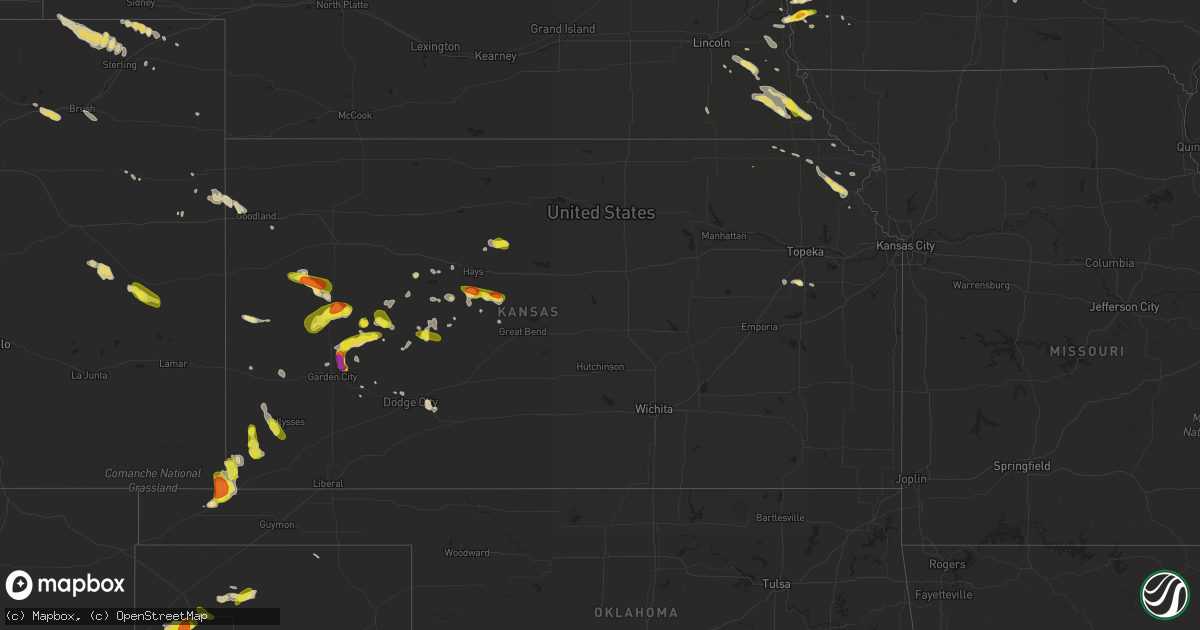
Hail Map in Kansas on June 22, 2017
Get this storm
June 22 map
$229
one time, instant access
Download today. No call, no setup
Keep the $229
Bought the map and want the full workflow? Apply the entire $229 to a subscription within 7 days. None of it is wasted.
Every map, not just this one
This buys you this map. Subscription and you get every map we run, in the markets you choose from a few cities to whole states to nationwide. Plus real-time alerts the moment a storm fires.
Contact data
Name, contact info, occupancy, even credit band for addresses in the footprint. You go from where it hit to who to call.
Become the source they trust
Unlimited branding weather history reports on demand. You already have the documented answer ready for the property owner, and you are the one who showed up with it.
Property data and RoofTrace estimates
Pull up any address you have got, its value and the exact code rules for that jurisdiction, straight from One Click Code. Then RoofTrace estimates the squares, pitch, and roof value, priced the way you price.
Storm reports in Kansas
Kansas
| Date | Description |
|---|---|
| 06/22/20176:12 PM CDT | A local report indicates 1.00 inch wind near 5 S JOHNSON CITY |
| 06/22/20176:10 PM CDT | A local report indicates 60 MPH wind near 5 S JOHNSON CITY |
| 06/21/20179:45 PM CDT | Report of a large tree limb down from a cocorahs observer. Time estimated from radar. |
| 06/21/20179:41 PM CDT | A local report indicates 1.00 inch wind near 3 W GALATIA |
| 06/21/20178:16 PM CDT | A local report indicates 60 MPH wind near 3 ENE DODGE CITY |
| 06/21/20178:06 PM CDT | A local report indicates 60 MPH wind near 2 NNE DODGE CITY |
| 06/21/20178:01 PM CDT | Ddc asos. |
| 06/21/20177:52 PM CDT | A local report indicates 58 MPH wind near LEOTI |
| 06/21/20177:18 PM CDT | A local report indicates 64 MPH wind near 3 N INGALLS |
| 06/21/20177:15 PM CDT | A local report indicates 60 MPH wind near TRIBUNE |
All States Impacted by Hail Map on June 22, 2017
Cities Impacted by Hail Map on June 22, 2017
- Kanorado, KS
- Goodland, KS
- Wakeeney, KS
- Ogden, IA
- Garden City, KS
- Goodell, IA
- Carson, IA
- Keyes, OK
- Goodwell, OK
- Walsh, CO
- Elkhart, KS
- Meservey, IA
- Pacific Junction, IA
- Glenwood, IA
- Ford, KS
- Scott City, KS
- Aredale, IA
- Dumont, IA
- Healy, KS
- Marienthal, KS
- Marble Rock, IA
- Nashua, IA
- Rudd, IA
- Rockwell, IA
- Dougherty, IA
- Floyd, IA
- Rockford, IA
- Nora Springs, IA
- Sheffield, IA
- Ionia, IA
- Lawler, IA
- Mason City, IA
- Hawkeye, IA
- New Hampton, IA
- Waucoma, IA
- Charles City, IA
- Fredericksburg, IA
- Cresco, IA
- Burlington, CO
- Swan, IA
- Pleasantville, IA
- Runnells, IA
- Prairie City, IA
- Knoxville, IA
- Clovis, NM
- Palmyra, NE
- Karval, CO
- Oakland, IA
- Wright, KS
- Allison, IA
- Burlingame, KS
- Curtice, OH
- Martin, OH
- Jetmore, KS
- Austin, MN
- Everest, KS
- Richfield, KS
- Johnson, KS
- Tribune, KS
- Scranton, KS
- La Salle, MI
- Erie, MI
- Warsaw, MN
- Faribault, MN
- Morristown, MN
- Dumas, TX
- Rippey, IA
- Perry, IA
- Liebenthal, KS
- Schoenchen, KS
- La Crosse, KS
- McCracken, KS
- Hays, KS
- Brownell, KS
- Houston, MN
- Brewster, MN
- Worthington, MN
- Reading, MN
- Strawberry Point, IA
- Arlington, IA
- Oregon, OH
- Millbury, OH
- Williston, OH
- Northwood, OH
- Iona, MN
- Slayton, MN
- Carlisle, IA
- Indianola, IA
- Ackworth, IA
- Des Moines, IA
- Pleasant Hill, IA
- Ankeny, IA
- Spirit Lake, IA
- Lamont, IA
- Lanesboro, MN
- Kit Carson, CO
- Rutland, IA
- Bradgate, IA
- Madrid, IA
- Woodward, IA
- Bouton, IA
- Granger, IA
- Lacona, IA
- Hartley, TX
- Estherville, IA
- Dunnell, MN
- Ceylon, MN
- Dolliver, IA
- Armstrong, IA
- Holcomb, KS
- Ree Heights, SD
- Miller, SD
- Lancaster, KS
- Exira, IA
- Hamlin, IA
- Audubon, IA
- Hampton, IA
- Bristow, IA
- Clarence, IA
- Humboldt, NE
- Stella, NE
- Auburn, NE
- Avoca, NE
- Nehawka, NE
- Nebraska City, NE
- Weeping Water, NE
- Otoe, NE
- Goldfield, IA
- Humboldt, IA
- Gilmore City, IA
- Livermore, IA
- Renwick, IA
- Hardy, IA
- Swea City, IA
- Temperance, MI
- Lime Springs, IA
- Ness City, KS
- Rushford, MN
- Alden, MN
- Albert Lea, MN
- Hartland, MN
- Kanawha, IA
- Dighton, KS
- Bazine, KS
- McIntire, IA
- Stacyville, IA
- Frost, MN
- Blue Earth, MN
- Bricelyn, MN
- Garner, IA
- Sibley, IA
- Chester, IA
- Channing, TX
- New Raymer, CO
- Sterling, CO
- Stoneham, CO
- Padroni, CO
- Merino, CO
- Brooksville, FL
- Hugo, CO
- Unadilla, NE
- Crook, CO
- Fayette, IA
- Maynard, IA
- Douglas, NE
- Burr, NE
- Syracuse, NE
- Cope, CO
- Britt, IA
- Alexander, IA
- Thornton, IA
- Klemme, IA
- Belmond, IA
- Ellis, KS
- Wiggins, CO
- Fort Morgan, CO
- Clutier, IA
- Verdon, NE
- Johnson, NE
- Tecumseh, NE
- Falls City, NE
- Shubert, NE
- Natoma, KS
- Paradise, KS
- Bode, IA
- Iliff, CO
- Peetz, CO
- Oelwein, IA
- Stanley, IA
- Aurora, IA
- Collyer, KS
- Ingalls, KS
- Oneida, KS
- Edson, KS
- Plattsmouth, NE
- Malvern, IA
- Dodge City, KS
- Otis, KS
- Bison, KS
- Norwalk, IA
- Milo, IA
- Elkader, IA
- Wadena, IA
- Volga, IA
- Elgin, IA
- Winona, KS
- Oakley, KS
- Denton, KS
- White Cloud, KS
- Robinson, KS
- Holabird, SD
- Highmore, SD
- Rushmore, MN
- Wilmont, MN
- Fulda, MN
- Cimarron, KS
- Riceville, IA
- Stratton, CO
- Peterson, MN
- Le Roy, MN
- Preston, MN
- Harmony, MN
- Cummings, KS
- Horton, KS
- Atchison, KS
- Elk Creek, NE
- Iowa Falls, IA
- Ackley, IA
- Effingham, KS
- Hiawatha, KS
- Harris, IA
- Ocheyedan, IA
- Clarksville, IA
- Greene, IA
- Luckey, OH
- Stony Ridge, OH
- Bowling Green, OH
- Perrysburg, OH
- Spring Valley, MN
- Ostrander, MN
- Alexander, KS
- Dubuque, IA
- La Motte, IA
- Masonville, IA
- Manchester, IA
- Ulysses, KS
- Plainville, KS
- Victoria, KS
- Catharine, KS
- Medford, MN
- Waterville, MN
- Cactus, TX
- Sunray, TX
- Stratford, TX
- Harrold, SD
- Adrian, TX
- Tracy, IA
- Clarion, IA
- Sabetha, KS
- Fairview, KS
- Council Bluffs, IA
- Adrian, MN
- Grimes, IA
- Spearville, KS
- Berwick, IA
- West Des Moines, IA
- Urbandale, IA
- Clive, IA
- Johnston, IA
- Windsor Heights, IA
- Polk City, IA
- Easton, MN
- Elmore, MN
- Talmage, NE
- Monroe, MI
- Red Oak, IA
- Seneca, KS
- Bern, KS
- Albert, KS
- Powersville, MO
- Lucerne, MO
- Latimer, IA
- Chapin, IA
- Clear Lake, IA
- Swaledale, IA
- Corwith, IA
- Geneva, IA
- Toledo, IA
- Decorah, IA
- Table Rock, NE
- Dawson, NE
- Cook, NE
- Osage, IA
- Syracuse, KS
- Blunt, SD
- Sedgwick, CO
- Bushnell, NE
- Pilot Mound, IA
- Grand Junction, IA
- Boone, IA
- Shell Rock, IA
- Parkersburg, IA
- Fairbank, IA
- Readlyn, IA
- Utica, KS
- Hillsboro, WI
- La Farge, WI
- Wells, MN
- Orchard, IA
- Purdin, MO
- Linneus, MO
- Pemberville, OH
- Genoa, OH
- Walbridge, OH
- Hickman, NE
- Beeler, KS
- Edgewood, IA
- Silver City, IA
- Mineola, IA
- Bennet, NE
- Vermillion, KS
- Ogallah, KS
- Emerson, IA
- Haynesville, LA
- Waterloo, IA
- Denver, IA
- Thor, IA
- Wray, CO
- Winthrop, IA
- Independence, IA
- Kilkenny, MN
- Lakin, KS
- Rowan, IA
- Carbondale, KS
- Overbrook, KS
- Beatrice, NE
- Rowley, IA
- Walker, IA
- Adams, NE
- Viola, WI
- Ledyard, IA
- Lakota, IA
- Round Lake, MN
- Harvey, IA
- Hartford, IA
- Steamboat Rock, IA
- Powhattan, KS
- Chandler, MN
- Badger, IA
- Sumner, IA
- Randalia, IA
- West Union, IA
- Garnavillo, IA
- Brush, CO
- Midland, MI
- Linwood, MI
- Jesup, IA
- Troy, KS
- Bendena, KS
- Shamrock, TX
- Dodgeville, WI
- Mineral Point, WI
- Browning, MO
- Ransom, KS
- Patagonia, AZ
- Fleming, CO
- Adams, MN
- Elkton, MN
- Taopi, MN
- Grand Meadow, MN
- Avoca, IA
- Treynor, IA
- Macedonia, IA
- Kimballton, IA
- Adair, IA
- Eldora, IA
- Bosworth, MO
- Rose Creek, MN
- Winigan, MO
- Hayward, MN
- Guttenberg, IA
- Colesburg, IA
- Garber, IA
- Kirk, CO
- Lake Park, IA
- Little Rock, IA
- Bigelow, MN
- Carrollton, MO
- De Witt, MO
- Manitowoc, WI
- Whitelaw, WI
- Collins, WI
- Reedsville, WI
- Chilton, WI
- Valders, WI
- Hopkinton, IA
- Perryton, TX
- Windom, MN
- Heron Lake, MN
- Bellevue, NE
- Akron, CO
- Murray, NE
- Avoca, MN
- Eads, CO
- Hastings, IA
- Altoona, IA
- Monroe, IA
- Otley, IA
- Campo, CO
- Pfeifer, KS
- Dalhart, TX


