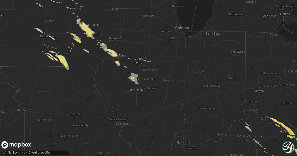
Hail Map in Illinois on June 21, 2016
Get this storm
June 21 map
$229
one time, instant access
Download today. No call, no setup
Keep the $229
Bought the map and want the full workflow? Apply the entire $229 to a subscription within 7 days. None of it is wasted.
Every map, not just this one
This buys you this map. Subscription and you get every map we run, in the markets you choose from a few cities to whole states to nationwide. Plus real-time alerts the moment a storm fires.
Contact data
Name, contact info, occupancy, even credit band for addresses in the footprint. You go from where it hit to who to call.
Become the source they trust
Unlimited branding weather history reports on demand. You already have the documented answer ready for the property owner, and you are the one who showed up with it.
Property data and RoofTrace estimates
Pull up any address you have got, its value and the exact code rules for that jurisdiction, straight from One Click Code. Then RoofTrace estimates the squares, pitch, and roof value, priced the way you price.
Storm reports in Illinois
Illinois
| Date | Description |
|---|---|
| 06/21/20165:48 AM CDT | Large tree branches down. Time estimated. |
| 06/21/20165:40 AM CDT | 9 trees blown down |
| 06/21/20165:20 AM CDT | Trees and tree limbs down in town. One power pole snapped. One power line down. |
| 06/21/20165:00 AM CDT | 4 power poles snapped off and 4 irrigation legs flipped. Location was 2900e and 850n. Also at 2800e and north of 850n... Multiple 18 inch or greater trees were snapped |
| 06/21/20165:00 AM CDT | Power lines blown down. From county ema. |
| 06/21/20164:48 AM CDT | 5 power poles snapped off near power station... West of route 97 on county road 1500e. Reported by county ema. |
| 06/21/20164:47 AM CDT | Tree limbs and power lines down |
| 06/21/20164:33 AM CDT | Tree down on rt. 95 |
| 06/21/20164:10 AM CDT | Two reports of trees down on homes in monmouth due to thunderstorm winds. One tree had fallen on house at monmouth college the other was a tree down on a mobile home in |
| 06/21/20163:35 AM CDT | Delayed report. 4 inch branches down and corn flattened. |
| 06/21/20163:27 AM CDT | Mercer county sheriffs office reported a large tree limb down along route 17. |
| 06/21/20163:10 AM CDT | Two reports of trees down on homes in monmouth due to thunderstorm winds. One tree had fallen on house at monmouth college the other was a tree down on a mobile home in |
All States Impacted by Hail Map on June 21, 2016
Cities Impacted by Hail Map on June 21, 2016
- Gettysburg, PA
- New Oxford, PA
- Davidsonville, MD
- Edgewater, MD
- Riva, MD
- Annapolis, MD
- Kalona, IA
- Iowa City, IA
- Homestead, IA
- Watkins, IA
- Walford, IA
- Norway, IA
- Tiffin, IA
- Swisher, IA
- Marengo, IA
- Blairstown, IA
- Middle Amana, IA
- Oxford, IA
- Newhall, IA
- Fairfax, IA
- Van Horne, IA
- Amana, IA
- Atkins, IA
- North Liberty, IA
- Coralville, IA
- Gann Valley, SD
- Kimball, SD
- Amidon, ND
- New England, ND
- Wood, SD
- Brockton, MT
- Fairview, MT
- Boyds, MD
- Minford, OH
- Jackson, OH
- Oak Hill, OH
- Mystic, IA
- Russell, IA
- Moulton, IA
- Centerville, IA
- Albia, IA
- Exline, IA
- Cincinnati, IA
- Melrose, IA
- Udell, IA
- Plano, IA
- Coatsville, MO
- Moravia, IA
- Livonia, MO
- Unionville, MO
- Corydon, IA
- Humeston, IA
- Falling Waters, WV
- Williamsport, MD
- Bismarck, ND
- Sterling, ND
- Menoken, ND
- Gibson, IA
- Brooklyn, IA
- South English, IA
- Webster, IA
- Harper, IA
- North English, IA
- Malcom, IA
- Montezuma, IA
- Keswick, IA
- Sigourney, IA
- Guernsey, IA
- Deep River, IA
- Alexander, ND
- Mason City, IL
- Belvidere, SD
- Adamstown, MD
- Brandywine, MD
- Wessington Springs, SD
- Baldwin, ND
- Wilton, ND
- Wishek, ND
- Clifton, VA
- Purcellville, VA
- Sterling, VA
- Haymarket, VA
- Ashburn, VA
- Leesburg, VA
- Chantilly, VA
- Bluemont, VA
- Boyce, VA
- Upperville, VA
- Manassas, VA
- Centreville, VA
- Herndon, VA
- Middleburg, VA
- Reston, VA
- Berryville, VA
- Aldie, VA
- Paris, VA
- Fairfax, VA
- The Plains, VA
- Marshall, VA
- Round Hill, VA
- Eidson, TN
- Cartwright, ND
- Runnells, IA
- Pleasant Hill, IA
- Greenview, IL
- Lucas, IA
- Chariton, IA
- White River, SD
- Winner, SD
- Center, ND
- Culbertson, MT
- Wolf Point, MT
- Frazer, MT
- Galena, MD
- Chestertown, MD
- Millington, MD
- Worton, MD
- Still Pond, MD
- Betterton, MD
- Kennedyville, MD
- Lovettsville, VA
- Napoleon, ND
- Kintyre, ND
- Hartly, DE
- Tyner, KY
- McKee, KY
- Miracle, KY
- Murdo, SD
- Dover, DE
- Dover Afb, DE
- Camden Wyoming, DE
- Holabird, SD
- Highmore, SD
- Falmouth, KY
- Sumerco, WV
- Saint Albans, WV
- Hurricane, WV
- Ashford, WV
- Dunbar, WV
- Winfield, WV
- Alum Creek, WV
- Milton, WV
- Eleanor, WV
- Poca, WV
- Gallipolis, OH
- Nitro, WV
- Glenwood, WV
- Patriot, OH
- South Charleston, WV
- Charleston, WV
- Scott Depot, WV
- Ashton, WV
- Sod, WV
- Fraziers Bottom, WV
- Tornado, WV
- Red House, WV
- Crown City, OH
- Wall, SD
- Howes, SD
- Milesville, SD
- Oneida, KY
- Webbville, KY
- Louisa, KY
- Peoria, IL
- Kimberly, WV
- Powellton, WV
- George, IA
- Spencer, WV
- Dysart, IA
- Keystone, IA
- Garrison, IA
- Emery, SD
- Spencer, SD
- Bridgewater, SD
- Mitchell, SD
- Plankinton, SD
- Salem, SD
- Alexandria, SD
- Fulton, SD
- Mount Vernon, SD
- Chinook, MT
- Watford City, ND
- Waterford, VA
- Pomfret, MD
- La Plata, MD
- White Plains, MD
- Waldorf, MD
- Lower Brule, SD
- Grayson, KY
- Bowman, ND
- Muscatine, IA
- Fruitland, IA
- Granada, MN
- Fairmont, MN
- Lefor, ND
- Fort Thompson, SD
- Chamberlain, SD
- Fort Pierre, SD
- Kennebec, SD
- Ree Heights, SD
- Midland, SD
- Reliance, SD
- Pierre, SD
- Onida, SD
- Hayes, SD
- White Lake, SD
- Presho, SD
- Harrold, SD
- Miller, SD
- Blunt, SD
- Lanham, MD
- Glenn Dale, MD
- Bowie, MD
- Gainesville, VA
- Hamilton, VA
- Catharpin, VA
- Lakefield, MN
- Okabena, MN
- Fort Ashby, WV
- Capon Bridge, WV
- Bloomery, WV
- Paw Paw, WV
- Springfield, WV
- Points, WV
- Green Spring, WV
- Slanesville, WV
- Ridgeley, WV
- Levels, WV
- Clear Lake, IA
- Greene, IA
- Crystal Lake, IA
- Thompson, IA
- Fertile, IA
- Rockford, IA
- Ledyard, IA
- Lake Mills, IA
- Woden, IA
- Rockwell, IA
- Nora Springs, IA
- Garner, IA
- Marble Rock, IA
- Dougherty, IA
- Elmore, MN
- Mason City, IA
- Blue Earth, MN
- Buffalo Center, IA
- Leland, IA
- Lakota, IA
- Ventura, IA
- Britt, IA
- Swea City, IA
- Forest City, IA
- Arnegard, ND
- Grassy Butte, ND
- Hinsdale, MT
- Pilgrim, KY
- Frederick, MD
- Sudlersville, MD
- Barclay, MD
- Parsonsburg, MD
- Salisbury, MD
- Manchester, OH
- West Union, OH
- Lynx, OH
- Stout, OH
- Selma, IA
- Douds, IA
- Libertyville, IA
- New Salem, ND
- Stanton, ND
- Hampton, IA
- Geneva, IA
- Charles Town, WV
- Harpers Ferry, WV
- Graham, MO
- Barnard, MO
- Maryville, MO
- Skidmore, MO
- Ashley, ND
- Charlottesville, VA
- Hartford, SD
- Rhame, ND
- Lehr, ND
- Kensett, IA
- Manly, IA
- Underwood, ND
- West Friendship, MD
- Cooksville, MD
- Woodbine, MD
- Sykesville, MD
- Glenelg, MD
- Columbia, MD
- Ellicott City, MD
- Glenwood, MD
- Mount Airy, MD
- Marriottsville, MD
- Hulen, KY
- Hyattsville, MD
- Martinsburg, WV
- Hazen, ND
- Fairplay, MD
- Keedysville, MD
- Boonsboro, MD
- Middletown, MD
- Jefferson, MD
- Braddock Heights, MD
- Rohrersville, MD
- Buckeystown, MD
- Shepherdstown, WV
- Sharpsburg, MD
- Brewster, MN
- Whitewater, MT
- Killdeer, ND
- Mandaree, ND
- Des Moines, IA
- Pittsville, MD
- Smyrna, DE
- Dunkerton, IA
- Jesup, IA
- Fairbank, IA
- Okaton, SD
- Cedar Falls, IA
- Sherwood, ND
- Long Valley, SD
- Kadoka, SD
- Regent, ND
- Belfield, ND
- Medora, ND
- McLaughlin, SD
- Selfridge, ND
- Halliday, ND
- Dodge, ND
- Mott, ND
- Frostburg, MD
- Cumberland, MD
- Spencer, IA
- Fourmile, KY
- Middlesboro, KY
- Pineville, KY
- Calvin, KY
- Syria, VA
- Stanley, VA
- Culpeper, VA
- Luray, VA
- Reva, VA
- Madison, VA
- Sperryville, VA
- Haywood, VA
- Etlan, VA
- Bayville, NJ
- Lanoka Harbor, NJ
- Driscoll, ND
- Moffit, ND
- Gackle, ND
- Hazelton, ND
- Braddock, ND
- Hanover, MD
- Jessup, MD
- Elkridge, MD
- Worthington, MN
- Fulda, MN
- Bowbells, ND
- Poplar, MT
- Brighton, IA
- Fairfield, IA
- Catlettsburg, KY
- Rush, KY
- Argillite, KY
- Ashland, KY
- Roseglen, ND
- Parshall, ND
- Ryder, ND
- Easton, IL
- Woodward, IA
- Grimes, IA
- Bouton, IA
- Minburn, IA
- Granger, IA
- Perry, IA
- Dallas Center, IA
- Mandan, ND
- Harrington, DE
- Greenwood, DE
- Bridgeville, DE
- Hanover, PA
- Spring Grove, PA
- York, PA
- Abbottstown, PA
- Thomasville, PA
- Needmore, PA
- Edgeley, ND
- Harlem, MT
- Hays, MT
- Knoxville, IL
- Kirksville, MO
- Grottoes, VA
- Mount Crawford, VA
- Weyers Cave, VA
- Hettinger, ND
- Baltimore, MD
- Linthicum Heights, MD
- Myersville, MD
- Thurmont, MD
- Keene, ND
- Williston, ND
- Odin, MN
- Maynardville, TN
- Carson, ND
- Beulah, ND
- Zap, ND
- Parsons, WV
- Dunnell, MN
- Queen City, MO
- Greentop, MO
- Worthington, MO
- Garrison, ND
- Coleharbor, ND
- New Town, ND
- Campbellsburg, IN
- Onaka, SD
- Hoven, SD
- Tolstoy, SD
- Ayrshire, IA
- Webb, IA
- Hagerstown, MD
- Owenton, KY
- Corinth, KY
- Sadieville, KY
- Georgetown, KY
- Scobey, MT
- Plainfield, IA
- Clarksville, IA
- Summit Point, WV
- Stephenson, VA
- Berwick, IL
- Avon, IL
- Roseville, IL
- Harlan, KY
- Rose Hill, IA
- Flaxville, MT
- Beckley, WV
- Kiester, MN
- Scarville, IA
- Bricelyn, MN
- Brashear, MO
- Loring, MT
- Nashua, MT
- Glasgow, MT
- Bainville, MT
- Rock Rapids, IA
- Jonesville, VA
- Derby, IA
- Alamo, ND
- Irvine, KY
- Beattyville, KY
- Church Hill, MD
- Rock Hall, MD
- Ingleside, MD
- Centreville, MD
- Henderson, MD
- Creston, WV
- Forest City, IL
- Germantown, MD
- Webster Springs, WV
- Bergoo, WV
- La Porte City, IA
- Promise City, IA
- East Bernstadt, KY
- London, KY
- Vinton, IA
- South Amana, IA
- Elberon, IA
- Lone Tree, IA
- Luzerne, IA
- Williamsburg, IA
- Riverside, IA
- Solon, IA
- Parnell, IA
- Clutier, IA
- Wellman, IA
- Free Union, VA
- Crozet, VA
- Port Republic, VA
- Trenton, NJ
- Silver Spring, MD
- Lakehurst, NJ
- Manchester Township, NJ
- Jackson, NJ
- Toms River, NJ
- Lakewood, NJ
- Brick, NJ
- Queen Anne, MD
- Cameron, IL
- Townsend, DE
- Given, WV
- Advent, WV
- Liberty, WV
- Ripley, WV
- Leon, WV
- Kenna, WV
- Everly, IA
- Ellendale, DE
- Georgetown, DE
- Bowdle, SD
- Keithsburg, IL
- New Boston, IL
- Alexis, IL
- Seaton, IL
- Little York, IL
- Monmouth, IL
- Gerlaw, IL
- Joy, IL
- Aledo, IL
- Waynesboro, PA
- Bryans Road, MD
- Accokeek, MD
- Indian Head, MD
- Woonsocket, SD
- Woodburn, IA
- Millerton, IA
- Seymour, IA
- Oakville, IA
- Galesburg, IL
- Greenup, KY
- Welcome, MN
- Winchester, KY
- Riverdale, ND
- Comfort, WV
- Winifrede, WV
- Hernshaw, WV
- Jackson, MN
- Union Bridge, MD
- Hebron, MD
- Vienna, MD
- Mardela Springs, MD
- Gibbs, MO
- Novinger, MO
- Upper Marlboro, MD
- Blue Creek, OH
- Vanceburg, KY
- Garrison, KY
- Keswick, VA
- Mitchell, IN
- Shoals, IN
- Metamora, IL
- Crane, IN
- Loogootee, IN
- Williams, IN
- Taylor, ND
- Gladstone, ND
- Yates City, IL
- Williamsfield, IL
- Elmwood, IL
- Montgomery Village, MD
- Washington Grove, MD
- Derwood, MD
- Gaithersburg, MD
- What Cheer, IA
- Grinnell, IA
- Froid, MT
- Fairfax, MO
- Kearneysville, WV
- Shenandoah Junction, WV
- Richmond, KY
- Waco, KY
- Curlew, IA
- Lucasville, OH
- Plainville, IN
- Elnora, IN
- Williamsburg, KY
- Arjay, KY
- Walker, KY
- Duck, WV
- Ivydale, WV
- Dille, WV
- Scottsville, KY
- Adolphus, KY
- Malta, MT
- Dodson, MT
- Earleville, MD
- Wildrose, ND
- Crosby, ND
- Clarksburg, MD
- Dickerson, MD
- Letts, IA
- Wapello, IA
- Aquasco, MD
- Benedict, MD
- Charlotte Hall, MD
- Prince Frederick, MD
- Mechanicsville, MD
- Hughesville, MD
- Fort Washington, MD
- Bryantown, MD
- Canton, IL
- Oil Springs, KY
- Staffordsville, KY
- Hagerhill, KY
- Zahl, ND
- Olive Hill, KY
- Emerson, KY
- Prairie City, IA
- Altoona, IA
- Potomac, MD
- New Leipzig, ND
- Elgin, ND
- Columbia, IA
- New Market, MD
- Damascus, MD
- Monrovia, MD
- Ijamsville, MD
- Richardton, ND
- Dunn Center, ND
- Dickinson, ND
- Manning, ND
- Golden Valley, ND
- Alexander, IA
- Latimer, IA
- Quincy, KY
- South Shore, KY
- Winchester, OH
- Russellville, OH
- Douglas, ND
- Finley, TN
- Bristow, VA
- Nokesville, VA
- North East, MD
- Kingsville, MD
- Union City, TN
- Barnegat, NJ
- Waretown, NJ
- Barnegat Light, NJ
- Beach Haven, NJ
- Saint Augustine, IL
- Abingdon, IL
- Prairie City, IL
- Stout, IA
- Dike, IA
- Parkersburg, IA
- New Hartford, IA
- Franklin, KY
- Sharps Chapel, TN
- Riverdale, MD
- College Park, MD
- Greenbelt, MD
- Hedgesville, WV
- Ocheyedan, IA
- Milford, DE
- Milton, DE
- Lincoln, DE
- Woolstock, IA
- Alpha, MN
- Snow Hill, MD
- Seven Valleys, PA
- Stewartsville, MO
- Clarksdale, MO
- Crumpton, MD
- Timberville, VA
- Mount Jackson, VA
- Mathias, WV
- Bergton, VA
- Broadway, VA
- Quicksburg, VA
- Washburn, IL
- Roanoke, IL
- Pikeville, KY
- Prestonsburg, KY
- Varney, KY
- Gulston, KY
- Humboldt, IA
- Thor, IA
- Washburn, ND
- Booneville, KY
- Fenton, IA
- Lone Rock, IA
- El Paso, IL
- Saco, MT
- Steele, ND
- Gray, KY
- Barbourville, KY
- Gwynn Oak, MD
- Pikesville, MD
- Windsor Mill, MD
- Fredonia, ND
- Port Republic, MD
- Saint Leonard, MD
- Earlysville, VA
- Knoxville, MD
- Walkersville, MD
- Manchester, KY
- Mount Zion, WV
- Battle Creek, IA
- Clear Brook, VA
- Lake Park, IA
- Paoli, IN
- Springfield, TN
- Orlinda, TN
- Rippey, IA
- Dawson, IA
- Waterloo, IA
- Hudson, IA
- Forbes, ND
- Spirit Lake, IA
- Speedwell, TN
- Seaman, OH
- Salyersville, KY
- Van Lear, KY
- Auxier, KY
- Sidney, KY
- East Point, KY
- Debord, KY
- Scranton, ND
- Ludlow, SD
- Beltsville, MD
- Burtonsville, MD
- Laurel, MD
- Milo, IA
- Seaford, DE
- Kyles Ford, TN
- Blackwater, VA
- Calvin, WV
- Richwood, WV
- Craigsville, WV
- Fenwick, WV
- Summersville, WV
- Tioga, WV
- Clinton, MD
- Bethpage, TN
- Portland, TN
- Westmoreland, TN
- Armstrong, IA
- Richland, IA
- Lockridge, IA
- Heron Lake, MN
- Windom, MN
- Clear Spring, MD
- Mary Alice, KY
- Wallins Creek, KY
- Johnston, IA
- Cape May, NJ
- Rio Grande, NJ
- Benton, KY
- Dexter, KY
- Hardin, KY
- Almo, KY
- Mayfield, KY
- Kirksey, KY
- Steen, MN
- Hills, MN
- Wallback, WV
- Tuscarora, MD
- Point Of Rocks, MD
- Girdletree, MD
- Ottumwa, IA
- Eddyville, IA
- Barnesville, MD
- Beallsville, MD
- Flaxton, ND
- Wells, MN
- Orkney Springs, VA
- New Market, VA
- Indianola, IA
- Camden On Gauley, WV
- Delta, IA
- Dunlow, WV
- Fort Gay, WV
- Genoa, WV
- Siler, KY
- Columbus Junction, IA
- Conesville, IA
- New Virginia, IA
- Mount Savage, MD
- Cordova, MD
- Easton, MD
- Preston, MD
- Federalsburg, MD
- Denton, MD
- Elkhart, IL
- Athens, IL
- Glen Arm, MD
- Orleans, IN
- Palestine, WV
- Hancock, MD
- Berkeley Springs, WV
- Denton, KY
- Sherburn, MN
- Meadow, SD
- Kenneth, MN
- Adrian, MN
- Lismore, MN
- Bomont, WV
- Clendenin, WV
- Hickory, KY
- Harmans, MD
- Glen Burnie, MD
- Paeonian Springs, VA
- Woodstock, MD
- Clarksville, MD
- Lexington, KY
- Reading, MN
- Cowen, WV
- Erbacon, WV
- Felton, DE
- Fremont, IA
- Oskaloosa, IA
- Cedar, IA
- New Egypt, NJ
- Hardinsburg, IN
- Churchville, MD
- Rushmore, MN
- Baxter, KY
- Renick, WV
- East Peoria, IL
- Chillicothe, IL
- Hardy, IA
- Osceola, IA
- Hickman, KY
- Takoma Park, MD
- Chevy Chase, MD
- Secor, IL
- Pukwana, SD
- Kulm, ND
- Denver, IA
- Waverly, IA
- Readlyn, IA
- Flemington, WV
- Lowpoint, IL
- Dolliver, IA
- Max, ND
- Severna Park, MD
- Burke, VA
- Halethorpe, MD
- Oakton, VA
- Woodsboro, MD
- Lorton, VA
- Crownsville, MD
- Fairfax Station, VA
- Poolesville, MD
- Bladensburg, MD
- Delaplane, VA
- Washington, DC
- Pasadena, MD
- McLean, VA
- Severn, MD
- Harwood, MD
- Springfield, VA
- Spencerville, MD
- Burkittsville, MD
- Kensington, MD
- Millville, WV
- Alexandria, VA
- Fort George G Meade, MD
- Vienna, VA
- Falls Church, VA
- Dunn Loring, VA
- Mount Rainier, MD
- Millersville, MD
- Brunswick, MD
- Crofton, MD
- Big Pool, MD
- Catonsville, MD
- Inwood, WV
- Garrett Park, MD
- Odenton, MD
- Olney, MD
- Brooklyn, MD
- Winchester, VA
- Brookeville, MD
- Gerrardstown, WV
- Dayton, MD
- Bethesda, MD
- Gambrills, MD
- Brentwood, MD
- Rockville, MD
- Glenwood, MO
- Phelps, KY
- Harris, IA
- Round Lake, MN
- South Heart, ND
- Shields, ND
- Oquawka, IL
- Grandview, IA
- Hartley, IA
- Santa Fe, NM
- Fort Valley, VA
- Culloden, WV
- Burt, IA
- Algona, IA
- Elkview, WV
- Ashton, IA
- Great Cacapon, WV
- Paris, KY
- Linton, ND
- Midlothian, MD
- Tappen, ND
- Adairville, KY
- Lothian, MD
- Mercersburg, PA
- Churchton, MD
- Sparrows Point, MD
- Knox City, MO
- Glencoe, KY
- Jonesville, KY
- Dry Ridge, KY
- Williamstown, KY
- Berlin, MD
- San Jose, IL
- Havana, IL
- Green Valley, IL
- Petersburg, IL
- Manito, IL
- Topeka, IL
- Kilbourne, IL
- Lacona, IA
- Melcher Dallas, IA
- Dagmar, MT
- Georgetown, OH
- Columbus, ND
- Dickens, IA
- Ruthven, IA
- Fruitland, MD
- Eden, MD
- Morgantown, KY
- Tarkio, MO
- Rhodesdale, MD
- Ewing, VA
- Glen Ullin, ND
- Queenstown, MD
- Breeden, WV
- Prole, IA
- Catlett, VA
- Downing, MO
- Dunlap, IL
- Edwards, IL
- Nichols, IA
- Vincent, KY
- New Church, VA
- Greenbackville, VA
- Pocomoke City, MD
- Stockton, MD
- Chancellor, SD
- Reserve, MT
- Carlisle, KY
- McConnellsburg, PA
- Laurel, DE
- Delmar, DE
- Dundalk, MD
- Ravencliff, WV
- Owings, MD
- Newark, MD
- Willards, MD
- Princess Anne, MD
- Delmar, MD
- Wesley, IA
- Sibley, IA
- Bigelow, MN
- Eureka, IL
- Noonan, ND
- Suitland, MD
- Oxon Hill, MD
- Annandale, VA
- Andrews Air Force Base, MD
- Temple Hills, MD
- Eagle Grove, IA
- Sabillasville, MD
- Smithsburg, MD
- Little Birch, WV
- Sutton, WV
- Birch River, WV
- Eskdale, WV
- Ormsby, MN
- Clayton, DE
- Marlinton, WV
- Dumont, IA
- Dearborn, MO
- Camden Point, MO
- De Kalb, MO
- Kearney, MO
- Independence, MO
- Missouri City, MO
- Buckner, MO
- Excelsior Springs, MO
- Sibley, MO
- Liberty, MO
- Seaside Park, NJ
- Doylestown, PA
- Jamison, PA
- Warrington, PA
- Canisteo, NY
- Arkport, NY
- Bath, NY
- Hornell, NY
- Hagaman, NY
- Johnstown, NY
- Amsterdam, NY
- Gloversville, NY
- Broadalbin, NY
- Fort Johnson, NY
- Warsaw, NY
- Varysburg, NY
- Canaseraga, NY
- Castile, NY
- Dalton, NY
- Avoca, NY
- Wayland, NY
- Cohocton, NY
- Silver Springs, NY
- Dansville, NY
- Bliss, NY
- Mount Morris, NY
- Gainesville, NY
- North Java, NY
- Hunt, NY
- Nunda, NY
- Mount Holly Springs, PA
- Carlisle, PA
- East Berlin, PA
- Dover, PA
- Dillsburg, PA
- York Springs, PA
- Gardners, PA
- Boiling Springs, PA
- Newville, PA
- Washburn, TN
- Saint Marie, MT
- Wakpala, SD
- Pollock, SD
- Cross Junction, VA
- Basye, VA


