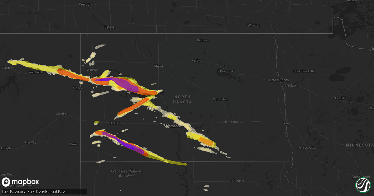
Hail Map in North Dakota on June 21, 2016
Get this storm
June 21 map
$229
one time, instant access
Download today. No call, no setup
Keep the $229
Bought the map and want the full workflow? Apply the entire $229 to a subscription within 7 days. None of it is wasted.
Every map, not just this one
This buys you this map. Subscription and you get every map we run, in the markets you choose from a few cities to whole states to nationwide. Plus real-time alerts the moment a storm fires.
Contact data
Name, contact info, occupancy, even credit band for addresses in the footprint. You go from where it hit to who to call.
Become the source they trust
Unlimited branding weather history reports on demand. You already have the documented answer ready for the property owner, and you are the one who showed up with it.
Property data and RoofTrace estimates
Pull up any address you have got, its value and the exact code rules for that jurisdiction, straight from One Click Code. Then RoofTrace estimates the squares, pitch, and roof value, priced the way you price.
Storm reports in North Dakota
North Dakota
| Date | Description |
|---|---|
| 06/21/20166:41 PM CDT | . |
| 06/21/20166:41 PM CDT | Hail was dime size at 639 pm and quarter size at 641 pm...and ongoing. |
| 06/21/20169:10 AM CDT | A local report indicates 1.50 inch wind near 5 S BEULAH BAY RECREATI |
| 06/21/20163:02 AM CDT | Frederick rwis. |
| 06/21/20162:57 AM CDT | Frederick rwis. 7 miles north of frederick. |
| 06/21/20162:05 AM CDT | Garden was destroyed with hail. Small hail was still present after daybreak. Power is still out. |
| 06/21/20161:58 AM CDT | A local report indicates 61 MPH wind near WISHEK |
| 06/21/20161:55 AM CDT | Lasted 5-10 minutes. |
| 06/21/20161:50 AM CDT | Power lines down south of napoleon on highway 3. Also a 70 foot structure toppled over. A farm south of napoleon sustained significant damage. Winds were estimated at 1 |
| 06/21/20161:25 AM CDT | Estimated 95 mph thunderstorm wind damage. Wind from a northerly direction. Tree tops snapped and blew 100 feet over the house and into the back yard. An 8 x 14 foot gr |
| 06/21/20161:20 AM CDT | Mesonet station 2 e moffit /ts633/ time estimated from radar. |
| 06/21/201612:50 AM CDT | Camper thrown and crushed... Pictures sent via email. |
| 06/21/201612:40 AM CDT | A local report indicates 75 MPH wind near 6 N BISMARCK |
| 06/21/201612:35 AM CDT | Many trees were downed in almont. Some trees fell onto cars...campers...and hit buildings as they fell. Time estimated. |
| 06/21/201612:25 AM CDT | A few trees down...winds estimated around 75 mph based on speeds measured north of bismarck. |
| 06/20/201611:22 PM CDT | A local report indicates 1.00 inch wind near 3 SW STANTON |
| 06/20/201611:00 PM CDT | A local report indicates 1.75 inch wind near 2 E GARRISON |
| 06/20/201610:55 PM CDT | A local report indicates 2.50 inch wind near 2 E MANDAREE |
| 06/20/201610:22 PM CDT | A local report indicates 1.00 inch wind near 3 SW STANTON |
| 06/20/201610:20 PM CDT | A local report indicates 1.00 inch wind near 17 SW SHIELDS |
| 06/20/201610:13 PM CDT | A local report indicates 1.50 inch wind near WATFORD CITY |
| 06/20/201610:13 PM CDT | A local report indicates 65 MPH wind near WATFORD CITY |
| 06/20/201610:12 PM CDT | A local report indicates 1.75 inch wind near 5 N WATFORD CITY |
| 06/20/201610:08 PM CDT | Golf ball sized hail at approximately 1008 pm cdt. Quarter sized hail was falling at 1012 pm cdt. |
| 06/20/20169:58 PM CDT | Picture relayed via social media. No damage reported. |
| 06/20/20169:46 PM CDT | Tornado on ground at time of call at 948 pm. The tornado had been on the ground for approximately two minutes prior to the call beginning at 946 pm. |
| 06/20/20169:33 PM CDT | Hail up to the size of tennis balls near the intersection of 31st avenue nw and 92nd avenue nw south of new town. |
| 06/20/20169:20 PM CDT | Late report from tuesday evening. Wind estimate unknown at this time. |
| 06/20/20169:19 PM CDT | Golf ball sized hail occurred for 11 minutes from 819 pm mdt until 830 pm mdt. |
| 06/20/20169:06 PM CDT | A local report indicates 80 MPH wind near KEENE |
| 06/20/20169:05 PM CDT | A local report indicates 2.50 inch wind near MOTT |
| 06/20/20169:00 PM CDT | A local report indicates 1.50 inch wind near KEENE |
| 06/20/20168:55 PM CDT | Late report. Hail followed by gusty wind to near 50 mph. The duration of the hail event was 10 minutes. |
| 06/20/20168:55 PM CDT | Also had 60 mph winds with storm. . |
| 06/20/20168:50 PM CDT | Earlier reports from emergency management were of damage to a house. The roof and garage were reported torn off the home. Law enforcement now reports that eye witnesses |
| 06/20/20168:48 PM CDT | A local report indicates 1.75 inch wind near 5 SSE REGENT |
| 06/20/20168:41 PM CDT | Still ongoing. |
| 06/20/20168:40 PM CDT | Still ongoing. |
| 06/20/20168:40 PM CDT | Still ongoing. |
| 06/20/20168:40 PM CDT | Late report. . The duration of the hail event was 4 minutes. |
| 06/20/20168:38 PM CDT | Still ongoing. |
| 06/20/20168:30 PM CDT | Mostly quarters... Few golf balls. |
| 06/20/20168:18 PM CDT | 25 mph winds... Temperature fell from 85 to 75 in 20 minutes. |
| 06/20/20168:18 PM CDT | A few baseball size hail pieces. |
| 06/20/20168:15 PM CDT | A local report indicates 3.00 inch wind near 1 SSW HETTINGER |
| 06/20/20168:15 PM CDT | Hail continues at the time of this lsr issuance. |
| 06/20/20167:55 PM CDT | Late report. Duration of event unknown as person was driving through the storm. |
| 06/20/20167:25 PM CDT | Walnut sized hail fell for 10 minutes. |
All States Impacted by Hail Map on June 21, 2016
Cities Impacted by Hail Map on June 21, 2016
- Gettysburg, PA
- New Oxford, PA
- Davidsonville, MD
- Edgewater, MD
- Riva, MD
- Annapolis, MD
- Kalona, IA
- Iowa City, IA
- Homestead, IA
- Watkins, IA
- Walford, IA
- Norway, IA
- Tiffin, IA
- Swisher, IA
- Marengo, IA
- Blairstown, IA
- Middle Amana, IA
- Oxford, IA
- Newhall, IA
- Fairfax, IA
- Van Horne, IA
- Amana, IA
- Atkins, IA
- North Liberty, IA
- Coralville, IA
- Gann Valley, SD
- Kimball, SD
- Amidon, ND
- New England, ND
- Wood, SD
- Brockton, MT
- Fairview, MT
- Boyds, MD
- Minford, OH
- Jackson, OH
- Oak Hill, OH
- Mystic, IA
- Russell, IA
- Moulton, IA
- Centerville, IA
- Albia, IA
- Exline, IA
- Cincinnati, IA
- Melrose, IA
- Udell, IA
- Plano, IA
- Coatsville, MO
- Moravia, IA
- Livonia, MO
- Unionville, MO
- Corydon, IA
- Humeston, IA
- Falling Waters, WV
- Williamsport, MD
- Bismarck, ND
- Sterling, ND
- Menoken, ND
- Gibson, IA
- Brooklyn, IA
- South English, IA
- Webster, IA
- Harper, IA
- North English, IA
- Malcom, IA
- Montezuma, IA
- Keswick, IA
- Sigourney, IA
- Guernsey, IA
- Deep River, IA
- Alexander, ND
- Mason City, IL
- Belvidere, SD
- Adamstown, MD
- Brandywine, MD
- Wessington Springs, SD
- Baldwin, ND
- Wilton, ND
- Wishek, ND
- Clifton, VA
- Purcellville, VA
- Sterling, VA
- Haymarket, VA
- Ashburn, VA
- Leesburg, VA
- Chantilly, VA
- Bluemont, VA
- Boyce, VA
- Upperville, VA
- Manassas, VA
- Centreville, VA
- Herndon, VA
- Middleburg, VA
- Reston, VA
- Berryville, VA
- Aldie, VA
- Paris, VA
- Fairfax, VA
- The Plains, VA
- Marshall, VA
- Round Hill, VA
- Eidson, TN
- Cartwright, ND
- Runnells, IA
- Pleasant Hill, IA
- Greenview, IL
- Lucas, IA
- Chariton, IA
- White River, SD
- Winner, SD
- Center, ND
- Culbertson, MT
- Wolf Point, MT
- Frazer, MT
- Galena, MD
- Chestertown, MD
- Millington, MD
- Worton, MD
- Still Pond, MD
- Betterton, MD
- Kennedyville, MD
- Lovettsville, VA
- Napoleon, ND
- Kintyre, ND
- Hartly, DE
- Tyner, KY
- McKee, KY
- Miracle, KY
- Murdo, SD
- Dover, DE
- Dover Afb, DE
- Camden Wyoming, DE
- Holabird, SD
- Highmore, SD
- Falmouth, KY
- Sumerco, WV
- Saint Albans, WV
- Hurricane, WV
- Ashford, WV
- Dunbar, WV
- Winfield, WV
- Alum Creek, WV
- Milton, WV
- Eleanor, WV
- Poca, WV
- Gallipolis, OH
- Nitro, WV
- Glenwood, WV
- Patriot, OH
- South Charleston, WV
- Charleston, WV
- Scott Depot, WV
- Ashton, WV
- Sod, WV
- Fraziers Bottom, WV
- Tornado, WV
- Red House, WV
- Crown City, OH
- Wall, SD
- Howes, SD
- Milesville, SD
- Oneida, KY
- Webbville, KY
- Louisa, KY
- Peoria, IL
- Kimberly, WV
- Powellton, WV
- George, IA
- Spencer, WV
- Dysart, IA
- Keystone, IA
- Garrison, IA
- Emery, SD
- Spencer, SD
- Bridgewater, SD
- Mitchell, SD
- Plankinton, SD
- Salem, SD
- Alexandria, SD
- Fulton, SD
- Mount Vernon, SD
- Chinook, MT
- Watford City, ND
- Waterford, VA
- Pomfret, MD
- La Plata, MD
- White Plains, MD
- Waldorf, MD
- Lower Brule, SD
- Grayson, KY
- Bowman, ND
- Muscatine, IA
- Fruitland, IA
- Granada, MN
- Fairmont, MN
- Lefor, ND
- Fort Thompson, SD
- Chamberlain, SD
- Fort Pierre, SD
- Kennebec, SD
- Ree Heights, SD
- Midland, SD
- Reliance, SD
- Pierre, SD
- Onida, SD
- Hayes, SD
- White Lake, SD
- Presho, SD
- Harrold, SD
- Miller, SD
- Blunt, SD
- Lanham, MD
- Glenn Dale, MD
- Bowie, MD
- Gainesville, VA
- Hamilton, VA
- Catharpin, VA
- Lakefield, MN
- Okabena, MN
- Fort Ashby, WV
- Capon Bridge, WV
- Bloomery, WV
- Paw Paw, WV
- Springfield, WV
- Points, WV
- Green Spring, WV
- Slanesville, WV
- Ridgeley, WV
- Levels, WV
- Clear Lake, IA
- Greene, IA
- Crystal Lake, IA
- Thompson, IA
- Fertile, IA
- Rockford, IA
- Ledyard, IA
- Lake Mills, IA
- Woden, IA
- Rockwell, IA
- Nora Springs, IA
- Garner, IA
- Marble Rock, IA
- Dougherty, IA
- Elmore, MN
- Mason City, IA
- Blue Earth, MN
- Buffalo Center, IA
- Leland, IA
- Lakota, IA
- Ventura, IA
- Britt, IA
- Swea City, IA
- Forest City, IA
- Arnegard, ND
- Grassy Butte, ND
- Hinsdale, MT
- Pilgrim, KY
- Frederick, MD
- Sudlersville, MD
- Barclay, MD
- Parsonsburg, MD
- Salisbury, MD
- Manchester, OH
- West Union, OH
- Lynx, OH
- Stout, OH
- Selma, IA
- Douds, IA
- Libertyville, IA
- New Salem, ND
- Stanton, ND
- Hampton, IA
- Geneva, IA
- Charles Town, WV
- Harpers Ferry, WV
- Graham, MO
- Barnard, MO
- Maryville, MO
- Skidmore, MO
- Ashley, ND
- Charlottesville, VA
- Hartford, SD
- Rhame, ND
- Lehr, ND
- Kensett, IA
- Manly, IA
- Underwood, ND
- West Friendship, MD
- Cooksville, MD
- Woodbine, MD
- Sykesville, MD
- Glenelg, MD
- Columbia, MD
- Ellicott City, MD
- Glenwood, MD
- Mount Airy, MD
- Marriottsville, MD
- Hulen, KY
- Hyattsville, MD
- Martinsburg, WV
- Hazen, ND
- Fairplay, MD
- Keedysville, MD
- Boonsboro, MD
- Middletown, MD
- Jefferson, MD
- Braddock Heights, MD
- Rohrersville, MD
- Buckeystown, MD
- Shepherdstown, WV
- Sharpsburg, MD
- Brewster, MN
- Whitewater, MT
- Killdeer, ND
- Mandaree, ND
- Des Moines, IA
- Pittsville, MD
- Smyrna, DE
- Dunkerton, IA
- Jesup, IA
- Fairbank, IA
- Okaton, SD
- Cedar Falls, IA
- Sherwood, ND
- Long Valley, SD
- Kadoka, SD
- Regent, ND
- Belfield, ND
- Medora, ND
- McLaughlin, SD
- Selfridge, ND
- Halliday, ND
- Dodge, ND
- Mott, ND
- Frostburg, MD
- Cumberland, MD
- Spencer, IA
- Fourmile, KY
- Middlesboro, KY
- Pineville, KY
- Calvin, KY
- Syria, VA
- Stanley, VA
- Culpeper, VA
- Luray, VA
- Reva, VA
- Madison, VA
- Sperryville, VA
- Haywood, VA
- Etlan, VA
- Bayville, NJ
- Lanoka Harbor, NJ
- Driscoll, ND
- Moffit, ND
- Gackle, ND
- Hazelton, ND
- Braddock, ND
- Hanover, MD
- Jessup, MD
- Elkridge, MD
- Worthington, MN
- Fulda, MN
- Bowbells, ND
- Poplar, MT
- Brighton, IA
- Fairfield, IA
- Catlettsburg, KY
- Rush, KY
- Argillite, KY
- Ashland, KY
- Roseglen, ND
- Parshall, ND
- Ryder, ND
- Easton, IL
- Woodward, IA
- Grimes, IA
- Bouton, IA
- Minburn, IA
- Granger, IA
- Perry, IA
- Dallas Center, IA
- Mandan, ND
- Harrington, DE
- Greenwood, DE
- Bridgeville, DE
- Hanover, PA
- Spring Grove, PA
- York, PA
- Abbottstown, PA
- Thomasville, PA
- Needmore, PA
- Edgeley, ND
- Harlem, MT
- Hays, MT
- Knoxville, IL
- Kirksville, MO
- Grottoes, VA
- Mount Crawford, VA
- Weyers Cave, VA
- Hettinger, ND
- Baltimore, MD
- Linthicum Heights, MD
- Myersville, MD
- Thurmont, MD
- Keene, ND
- Williston, ND
- Odin, MN
- Maynardville, TN
- Carson, ND
- Beulah, ND
- Zap, ND
- Parsons, WV
- Dunnell, MN
- Queen City, MO
- Greentop, MO
- Worthington, MO
- Garrison, ND
- Coleharbor, ND
- New Town, ND
- Campbellsburg, IN
- Onaka, SD
- Hoven, SD
- Tolstoy, SD
- Ayrshire, IA
- Webb, IA
- Hagerstown, MD
- Owenton, KY
- Corinth, KY
- Sadieville, KY
- Georgetown, KY
- Scobey, MT
- Plainfield, IA
- Clarksville, IA
- Summit Point, WV
- Stephenson, VA
- Berwick, IL
- Avon, IL
- Roseville, IL
- Harlan, KY
- Rose Hill, IA
- Flaxville, MT
- Beckley, WV
- Kiester, MN
- Scarville, IA
- Bricelyn, MN
- Brashear, MO
- Loring, MT
- Nashua, MT
- Glasgow, MT
- Bainville, MT
- Rock Rapids, IA
- Jonesville, VA
- Derby, IA
- Alamo, ND
- Irvine, KY
- Beattyville, KY
- Church Hill, MD
- Rock Hall, MD
- Ingleside, MD
- Centreville, MD
- Henderson, MD
- Creston, WV
- Forest City, IL
- Germantown, MD
- Webster Springs, WV
- Bergoo, WV
- La Porte City, IA
- Promise City, IA
- East Bernstadt, KY
- London, KY
- Vinton, IA
- South Amana, IA
- Elberon, IA
- Lone Tree, IA
- Luzerne, IA
- Williamsburg, IA
- Riverside, IA
- Solon, IA
- Parnell, IA
- Clutier, IA
- Wellman, IA
- Free Union, VA
- Crozet, VA
- Port Republic, VA
- Trenton, NJ
- Silver Spring, MD
- Lakehurst, NJ
- Manchester Township, NJ
- Jackson, NJ
- Toms River, NJ
- Lakewood, NJ
- Brick, NJ
- Queen Anne, MD
- Cameron, IL
- Townsend, DE
- Given, WV
- Advent, WV
- Liberty, WV
- Ripley, WV
- Leon, WV
- Kenna, WV
- Everly, IA
- Ellendale, DE
- Georgetown, DE
- Bowdle, SD
- Keithsburg, IL
- New Boston, IL
- Alexis, IL
- Seaton, IL
- Little York, IL
- Monmouth, IL
- Gerlaw, IL
- Joy, IL
- Aledo, IL
- Waynesboro, PA
- Bryans Road, MD
- Accokeek, MD
- Indian Head, MD
- Woonsocket, SD
- Woodburn, IA
- Millerton, IA
- Seymour, IA
- Oakville, IA
- Galesburg, IL
- Greenup, KY
- Welcome, MN
- Winchester, KY
- Riverdale, ND
- Comfort, WV
- Winifrede, WV
- Hernshaw, WV
- Jackson, MN
- Union Bridge, MD
- Hebron, MD
- Vienna, MD
- Mardela Springs, MD
- Gibbs, MO
- Novinger, MO
- Upper Marlboro, MD
- Blue Creek, OH
- Vanceburg, KY
- Garrison, KY
- Keswick, VA
- Mitchell, IN
- Shoals, IN
- Metamora, IL
- Crane, IN
- Loogootee, IN
- Williams, IN
- Taylor, ND
- Gladstone, ND
- Yates City, IL
- Williamsfield, IL
- Elmwood, IL
- Montgomery Village, MD
- Washington Grove, MD
- Derwood, MD
- Gaithersburg, MD
- What Cheer, IA
- Grinnell, IA
- Froid, MT
- Fairfax, MO
- Kearneysville, WV
- Shenandoah Junction, WV
- Richmond, KY
- Waco, KY
- Curlew, IA
- Lucasville, OH
- Plainville, IN
- Elnora, IN
- Williamsburg, KY
- Arjay, KY
- Walker, KY
- Duck, WV
- Ivydale, WV
- Dille, WV
- Scottsville, KY
- Adolphus, KY
- Malta, MT
- Dodson, MT
- Earleville, MD
- Wildrose, ND
- Crosby, ND
- Clarksburg, MD
- Dickerson, MD
- Letts, IA
- Wapello, IA
- Aquasco, MD
- Benedict, MD
- Charlotte Hall, MD
- Prince Frederick, MD
- Mechanicsville, MD
- Hughesville, MD
- Fort Washington, MD
- Bryantown, MD
- Canton, IL
- Oil Springs, KY
- Staffordsville, KY
- Hagerhill, KY
- Zahl, ND
- Olive Hill, KY
- Emerson, KY
- Prairie City, IA
- Altoona, IA
- Potomac, MD
- New Leipzig, ND
- Elgin, ND
- Columbia, IA
- New Market, MD
- Damascus, MD
- Monrovia, MD
- Ijamsville, MD
- Richardton, ND
- Dunn Center, ND
- Dickinson, ND
- Manning, ND
- Golden Valley, ND
- Alexander, IA
- Latimer, IA
- Quincy, KY
- South Shore, KY
- Winchester, OH
- Russellville, OH
- Douglas, ND
- Finley, TN
- Bristow, VA
- Nokesville, VA
- North East, MD
- Kingsville, MD
- Union City, TN
- Barnegat, NJ
- Waretown, NJ
- Barnegat Light, NJ
- Beach Haven, NJ
- Saint Augustine, IL
- Abingdon, IL
- Prairie City, IL
- Stout, IA
- Dike, IA
- Parkersburg, IA
- New Hartford, IA
- Franklin, KY
- Sharps Chapel, TN
- Riverdale, MD
- College Park, MD
- Greenbelt, MD
- Hedgesville, WV
- Ocheyedan, IA
- Milford, DE
- Milton, DE
- Lincoln, DE
- Woolstock, IA
- Alpha, MN
- Snow Hill, MD
- Seven Valleys, PA
- Stewartsville, MO
- Clarksdale, MO
- Crumpton, MD
- Timberville, VA
- Mount Jackson, VA
- Mathias, WV
- Bergton, VA
- Broadway, VA
- Quicksburg, VA
- Washburn, IL
- Roanoke, IL
- Pikeville, KY
- Prestonsburg, KY
- Varney, KY
- Gulston, KY
- Humboldt, IA
- Thor, IA
- Washburn, ND
- Booneville, KY
- Fenton, IA
- Lone Rock, IA
- El Paso, IL
- Saco, MT
- Steele, ND
- Gray, KY
- Barbourville, KY
- Gwynn Oak, MD
- Pikesville, MD
- Windsor Mill, MD
- Fredonia, ND
- Port Republic, MD
- Saint Leonard, MD
- Earlysville, VA
- Knoxville, MD
- Walkersville, MD
- Manchester, KY
- Mount Zion, WV
- Battle Creek, IA
- Clear Brook, VA
- Lake Park, IA
- Paoli, IN
- Springfield, TN
- Orlinda, TN
- Rippey, IA
- Dawson, IA
- Waterloo, IA
- Hudson, IA
- Forbes, ND
- Spirit Lake, IA
- Speedwell, TN
- Seaman, OH
- Salyersville, KY
- Van Lear, KY
- Auxier, KY
- Sidney, KY
- East Point, KY
- Debord, KY
- Scranton, ND
- Ludlow, SD
- Beltsville, MD
- Burtonsville, MD
- Laurel, MD
- Milo, IA
- Seaford, DE
- Kyles Ford, TN
- Blackwater, VA
- Calvin, WV
- Richwood, WV
- Craigsville, WV
- Fenwick, WV
- Summersville, WV
- Tioga, WV
- Clinton, MD
- Bethpage, TN
- Portland, TN
- Westmoreland, TN
- Armstrong, IA
- Richland, IA
- Lockridge, IA
- Heron Lake, MN
- Windom, MN
- Clear Spring, MD
- Mary Alice, KY
- Wallins Creek, KY
- Johnston, IA
- Cape May, NJ
- Rio Grande, NJ
- Benton, KY
- Dexter, KY
- Hardin, KY
- Almo, KY
- Mayfield, KY
- Kirksey, KY
- Steen, MN
- Hills, MN
- Wallback, WV
- Tuscarora, MD
- Point Of Rocks, MD
- Girdletree, MD
- Ottumwa, IA
- Eddyville, IA
- Barnesville, MD
- Beallsville, MD
- Flaxton, ND
- Wells, MN
- Orkney Springs, VA
- New Market, VA
- Indianola, IA
- Camden On Gauley, WV
- Delta, IA
- Dunlow, WV
- Fort Gay, WV
- Genoa, WV
- Siler, KY
- Columbus Junction, IA
- Conesville, IA
- New Virginia, IA
- Mount Savage, MD
- Cordova, MD
- Easton, MD
- Preston, MD
- Federalsburg, MD
- Denton, MD
- Elkhart, IL
- Athens, IL
- Glen Arm, MD
- Orleans, IN
- Palestine, WV
- Hancock, MD
- Berkeley Springs, WV
- Denton, KY
- Sherburn, MN
- Meadow, SD
- Kenneth, MN
- Adrian, MN
- Lismore, MN
- Bomont, WV
- Clendenin, WV
- Hickory, KY
- Harmans, MD
- Glen Burnie, MD
- Paeonian Springs, VA
- Woodstock, MD
- Clarksville, MD
- Lexington, KY
- Reading, MN
- Cowen, WV
- Erbacon, WV
- Felton, DE
- Fremont, IA
- Oskaloosa, IA
- Cedar, IA
- New Egypt, NJ
- Hardinsburg, IN
- Churchville, MD
- Rushmore, MN
- Baxter, KY
- Renick, WV
- East Peoria, IL
- Chillicothe, IL
- Hardy, IA
- Osceola, IA
- Hickman, KY
- Takoma Park, MD
- Chevy Chase, MD
- Secor, IL
- Pukwana, SD
- Kulm, ND
- Denver, IA
- Waverly, IA
- Readlyn, IA
- Flemington, WV
- Lowpoint, IL
- Dolliver, IA
- Max, ND
- Severna Park, MD
- Burke, VA
- Halethorpe, MD
- Oakton, VA
- Woodsboro, MD
- Lorton, VA
- Crownsville, MD
- Fairfax Station, VA
- Poolesville, MD
- Bladensburg, MD
- Delaplane, VA
- Washington, DC
- Pasadena, MD
- McLean, VA
- Severn, MD
- Harwood, MD
- Springfield, VA
- Spencerville, MD
- Burkittsville, MD
- Kensington, MD
- Millville, WV
- Alexandria, VA
- Fort George G Meade, MD
- Vienna, VA
- Falls Church, VA
- Dunn Loring, VA
- Mount Rainier, MD
- Millersville, MD
- Brunswick, MD
- Crofton, MD
- Big Pool, MD
- Catonsville, MD
- Inwood, WV
- Garrett Park, MD
- Odenton, MD
- Olney, MD
- Brooklyn, MD
- Winchester, VA
- Brookeville, MD
- Gerrardstown, WV
- Dayton, MD
- Bethesda, MD
- Gambrills, MD
- Brentwood, MD
- Rockville, MD
- Glenwood, MO
- Phelps, KY
- Harris, IA
- Round Lake, MN
- South Heart, ND
- Shields, ND
- Oquawka, IL
- Grandview, IA
- Hartley, IA
- Santa Fe, NM
- Fort Valley, VA
- Culloden, WV
- Burt, IA
- Algona, IA
- Elkview, WV
- Ashton, IA
- Great Cacapon, WV
- Paris, KY
- Linton, ND
- Midlothian, MD
- Tappen, ND
- Adairville, KY
- Lothian, MD
- Mercersburg, PA
- Churchton, MD
- Sparrows Point, MD
- Knox City, MO
- Glencoe, KY
- Jonesville, KY
- Dry Ridge, KY
- Williamstown, KY
- Berlin, MD
- San Jose, IL
- Havana, IL
- Green Valley, IL
- Petersburg, IL
- Manito, IL
- Topeka, IL
- Kilbourne, IL
- Lacona, IA
- Melcher Dallas, IA
- Dagmar, MT
- Georgetown, OH
- Columbus, ND
- Dickens, IA
- Ruthven, IA
- Fruitland, MD
- Eden, MD
- Morgantown, KY
- Tarkio, MO
- Rhodesdale, MD
- Ewing, VA
- Glen Ullin, ND
- Queenstown, MD
- Breeden, WV
- Prole, IA
- Catlett, VA
- Downing, MO
- Dunlap, IL
- Edwards, IL
- Nichols, IA
- Vincent, KY
- New Church, VA
- Greenbackville, VA
- Pocomoke City, MD
- Stockton, MD
- Chancellor, SD
- Reserve, MT
- Carlisle, KY
- McConnellsburg, PA
- Laurel, DE
- Delmar, DE
- Dundalk, MD
- Ravencliff, WV
- Owings, MD
- Newark, MD
- Willards, MD
- Princess Anne, MD
- Delmar, MD
- Wesley, IA
- Sibley, IA
- Bigelow, MN
- Eureka, IL
- Noonan, ND
- Suitland, MD
- Oxon Hill, MD
- Annandale, VA
- Andrews Air Force Base, MD
- Temple Hills, MD
- Eagle Grove, IA
- Sabillasville, MD
- Smithsburg, MD
- Little Birch, WV
- Sutton, WV
- Birch River, WV
- Eskdale, WV
- Ormsby, MN
- Clayton, DE
- Marlinton, WV
- Dumont, IA
- Dearborn, MO
- Camden Point, MO
- De Kalb, MO
- Kearney, MO
- Independence, MO
- Missouri City, MO
- Buckner, MO
- Excelsior Springs, MO
- Sibley, MO
- Liberty, MO
- Seaside Park, NJ
- Doylestown, PA
- Jamison, PA
- Warrington, PA
- Canisteo, NY
- Arkport, NY
- Bath, NY
- Hornell, NY
- Hagaman, NY
- Johnstown, NY
- Amsterdam, NY
- Gloversville, NY
- Broadalbin, NY
- Fort Johnson, NY
- Warsaw, NY
- Varysburg, NY
- Canaseraga, NY
- Castile, NY
- Dalton, NY
- Avoca, NY
- Wayland, NY
- Cohocton, NY
- Silver Springs, NY
- Dansville, NY
- Bliss, NY
- Mount Morris, NY
- Gainesville, NY
- North Java, NY
- Hunt, NY
- Nunda, NY
- Mount Holly Springs, PA
- Carlisle, PA
- East Berlin, PA
- Dover, PA
- Dillsburg, PA
- York Springs, PA
- Gardners, PA
- Boiling Springs, PA
- Newville, PA
- Washburn, TN
- Saint Marie, MT
- Wakpala, SD
- Pollock, SD
- Cross Junction, VA
- Basye, VA


