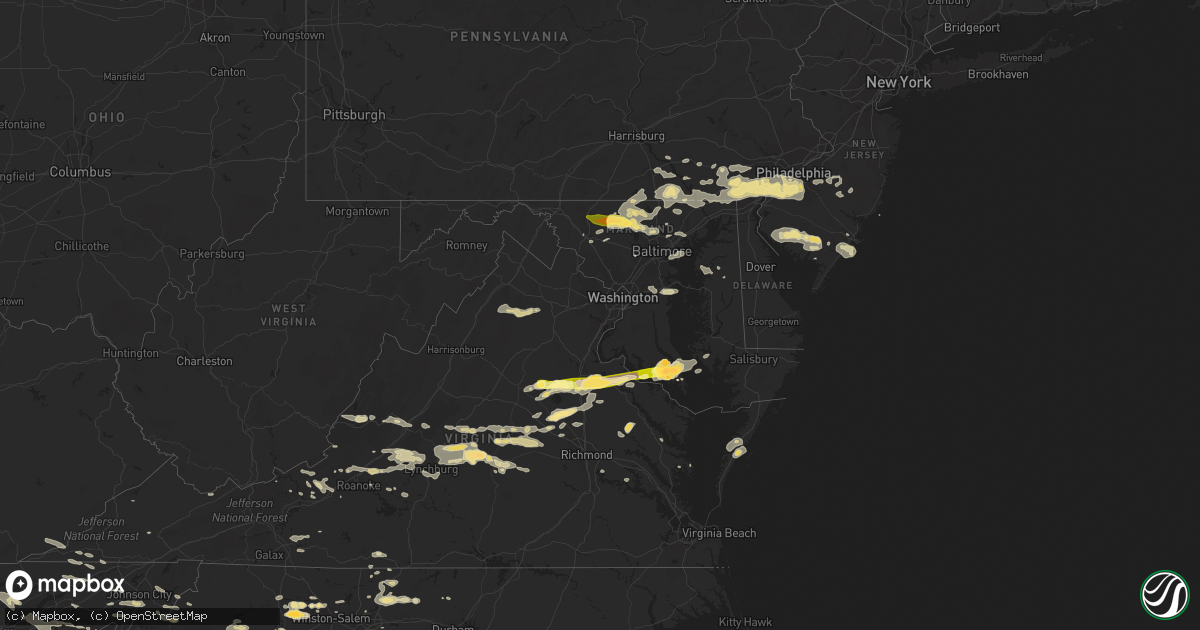
Hail Map in Maryland on June 13, 2013
Get this storm
June 13 map
$229
one time, instant access
Download today. No call, no setup
Keep the $229
Bought the map and want the full workflow? Apply the entire $229 to a subscription within 7 days. None of it is wasted.
Every map, not just this one
This buys you this map. Subscription and you get every map we run, in the markets you choose from a few cities to whole states to nationwide. Plus real-time alerts the moment a storm fires.
Contact data
Name, contact info, occupancy, even credit band for addresses in the footprint. You go from where it hit to who to call.
Become the source they trust
Unlimited branding weather history reports on demand. You already have the documented answer ready for the property owner, and you are the one who showed up with it.
Property data and RoofTrace estimates
Pull up any address you have got, its value and the exact code rules for that jurisdiction, straight from One Click Code. Then RoofTrace estimates the squares, pitch, and roof value, priced the way you price.
Storm reports in Maryland
Maryland
| Date | Description |
|---|---|
| 06/13/20134:26 PM CDT | Six inch tree limbs knocked onto neighbors house. Stop sign near intersection bent. |
| 06/13/20134:08 PM CDT | Kent island high school suffered roof damage and fence damage |
| 06/13/20134:00 PM CDT | Numerous trees uprooted along whiton road. |
| 06/13/20133:50 PM CDT | Tree across liners road |
| 06/13/20133:49 PM CDT | A local report indicates 68 MPH wind near STEVENSVILLE |
| 06/13/20133:45 PM CDT | Trees and wires down |
| 06/13/20133:45 PM CDT | Trees downed onto fence |
| 06/13/20133:45 PM CDT | Trees down on riverside dr. |
| 06/13/20133:40 PM CDT | Tree down blocking lane on us rte 13 |
| 06/13/20133:35 PM CDT | Numerous trees and power lines down in western part of county |
| 06/13/20133:30 PM CDT | Numerous trees and power poles snapped on whiton road |
| 06/13/20133:30 PM CDT | Trees and power lines down |
| 06/13/20133:30 PM CDT | Numerous trees and power lines down...some trees on homes and vehicles. Storage sheds blown over. Winds estd 70-75 mph. |
| 06/13/20133:30 PM CDT | Various damage at mardela springs middle and high schools. Softball dugouts destroyed...soccer goals damaged...bleachers blown over...and numerous trees sheared and som |
| 06/13/20133:20 PM CDT | Trees and power lines down across southern dorchester |
| 06/13/20133:18 PM CDT | Trees and power lines down |
| 06/13/20133:12 PM CDT | A tree fell onto a house in jessup. |
| 06/13/20133:12 PM CDT | 52 knot gust at bishops head. |
| 06/13/20133:12 PM CDT | A tree fell onto a house in jessup. Another tree down. Around apple ave and orchard ave. |
| 06/13/20133:11 PM CDT | Several trees downed...minor roff damage...a 20x20 quonset hut blown 20 yards. |
| 06/13/20133:11 PM CDT | Large tree downed onto us-50 |
| 06/13/20133:08 PM CDT | Tree down along all saints road. |
| 06/13/20133:06 PM CDT | Tree down along scaggsville road |
| 06/13/20133:06 PM CDT | Tree down on park hall dr near sandy spring rd |
| 06/13/20133:06 PM CDT | Tornado reported crossing norbeck rd and georgia ave |
| 06/13/20133:05 PM CDT | 1 tree uprooted into house. |
| 06/13/20133:04 PM CDT | A local report indicates 59 MPH wind near 2 ENE BELTSVILLE |
| 06/13/20133:03 PM CDT | Tree across liners road |
| 06/13/20133:00 PM CDT | Widespread trees down and structural damage to buildings. |
| 06/13/20132:59 PM CDT | Large tree uprooted near good hope rd and spencerville rd. |
| 06/13/20132:59 PM CDT | Tree down |
| 06/13/20132:56 PM CDT | A fallen tree crushed a car at the cloverly village shopping center. |
| 06/13/20132:55 PM CDT | Tree down near the intersection of randolph rd and new hampshire avenue. |
| 06/13/20132:54 PM CDT | Trees down. |
| 06/13/20132:53 PM CDT | Tree 9 inches in diameter was snapped mid-trunk with several large branches down in the stonegate neighborhood |
| 06/13/20132:49 PM CDT | Trees down |
| 06/13/20132:49 PM CDT | Tree snapped at montgomery village golf club |
| 06/13/20132:49 PM CDT | Several large trees down or split in 700 block of smallwood road. |
| 06/13/20132:49 PM CDT | Trees down and damage to building fascia. 600 block of lofstrand lane. |
| 06/13/20132:49 PM CDT | Measured on a hand-held anemometer |
| 06/13/20132:47 PM CDT | Possible tornado damage. Roof damage to ice arena. |
| 06/13/20132:46 PM CDT | Trees down near metro station. |
| 06/13/20132:46 PM CDT | Two inch diameter tree branches knocked down into side of a house. |
| 06/13/20132:45 PM CDT | One tree down and several 4 to 5 inch diameter limbs down in neighborhood |
| 06/13/20132:45 PM CDT | Knui |
| 06/13/20132:43 PM CDT | Several tree limbs blown down 4 to 6 inches in diameter. |
| 06/13/20132:43 PM CDT | Two trees down in front of a home in north potomac. |
| 06/13/20132:43 PM CDT | Roof of a farm outbuilding blown off... Additional damage to wood on the structure. A 10 inch diameter tree was snapped at the base and several large tree limbs were pu |
| 06/13/20132:43 PM CDT | Two foot diameter oak tree uprooted. Several tree limbs ripped off a 50 foot tall pine tree. Other trees seen stripped of their limbs to the northeast. Piles of downed |
| 06/13/20132:43 PM CDT | A local report indicates 61 MPH wind near 2 W SAINT INIGOES |
| 06/13/20132:43 PM CDT | 50 foot tall... 12 to 18 inch diameter tree uprooted across the street from the property at 3245 lloyd bowen road. |
| 06/13/20132:42 PM CDT | Several large trees down along joan dr. |
| 06/13/20132:41 PM CDT | Numerous trees down. |
| 06/13/20132:41 PM CDT | Roof of a farm outbuilding blown off... Additional damage to wood on the structure. A 10 inch diameter tree was snapped at the base and several large tree limbs were pu |
| 06/13/20132:41 PM CDT | Tree down on shady mile drive in california md. |
| 06/13/20132:41 PM CDT | A local report indicates 61 MPH wind near 2 SSE HOLLYWOOD |
| 06/13/20132:41 PM CDT | A lot of debris along query mill road and a cleanup crew moving and cutting downed trees and limbs up to 15 inches in diameter. Shingle damage to 13610 query mill road. |
| 06/13/20132:41 PM CDT | Trees down... Fence damage and clean up crews mulching debris at 10... 18... 2...5 and 6 glenhurst ct. Trees greater than 12 inches uprooted. A couple of trees up to 20 |
| 06/13/20132:41 PM CDT | Trees down on turkey foot rd just west of jones lane. |
| 06/13/20132:40 PM CDT | Shingles blown off of roof. 8 inch diamater tree limbs snapped off anf blown onto yard. Tree limbs piled up at curbside that had been blown off. Several snapped tree ba |
| 06/13/20132:40 PM CDT | Shingles blown off of roof. 8 inch diamater tree limbs snapped off anf blown onto yard. Tree limbs piled up at curbside that had been blown off. Several snapped tree ba |
| 06/13/20132:40 PM CDT | 4 to 8 inch tree limbs snapped off and sections of fencing blown over. |
| 06/13/20132:40 PM CDT | 12 foot long tree limb 4 to 6 inches in diamater blown onto power lines. |
| 06/13/20132:40 PM CDT | Baseball size hail and tree damage reported by trained spotter. |
| 06/13/20132:40 PM CDT | 12 foot long tree limb 4 to 6 inches in diamater blown onto power lines. |
| 06/13/20132:40 PM CDT | 4 to 8 inch tree limbs snapped off and sections of fencing blown over. |
| 06/13/20132:39 PM CDT | Shingle damage to 13328 manor stone drive. Several large tree limbs on lawn and a portion of a fence blown over. |
| 06/13/20132:39 PM CDT | Several trees and tree limbs up to 10 inches in diameter were blown onto driveway at 15400 river road hwy 190. The driveway was impassable. Clean up crew was removing t |
| 06/13/20132:39 PM CDT | Tree greater than 12 inches in diameter fell onto power pole and across river road hwy 190 just before manor stone drive. The tree was removed by a cleanup crew. The pr |
| 06/13/20132:39 PM CDT | Ef0. Max winds 70 mph. Path length 1.5 miles. Max width 100 yards. Multiple trees uprooted and snapped along town creek rd and woodlawn dr. |
| 06/13/20132:38 PM CDT | 8 inch diamater tree down at the intersection of seneca road rte 112 and esworthy road. |
| 06/13/20132:38 PM CDT | Trees down on the north and south sides of springfield road. Shingle damage to 14700 and 14721 springfield road. Tree limbs up to 8 inches in diameter cleared to the si |
| 06/13/20132:37 PM CDT | A tree fell into a powerline near the intersection of river road and partnership road. Tree limbs up to 8 inches in diameter have been cleared to the side of the road. |
| 06/13/20132:37 PM CDT | Numerous trees down. |
| 06/13/20132:35 PM CDT | Multiple 8 to 9 inch diameter tree branches knocked down |
| 06/13/20132:35 PM CDT | Numerous trees down. |
| 06/13/20132:32 PM CDT | Estimated thunderstorm wind gusts in excess of 70 mph near and to the south of leonardstown high school |
| 06/13/20132:32 PM CDT | A few trees were down including a 20-foot crape myrtle tree. Numerous limbs were also down. |
| 06/13/20132:28 PM CDT | Numerous trees down around coltons point. |
| 06/13/20132:28 PM CDT | 2 trees down in yard along tippit rd |
| 06/13/20132:27 PM CDT | Multiple trees down along lady baltimore ave |
| 06/13/20132:21 PM CDT | Multiple 3 to 5 inch diameter tree branches knocked down from coltons pt and waterloo circle area to coltons pt and oakley rd area. |
| 06/13/20138:30 AM CDT | A large tree fell next to the annapolis police station on taylor street...damaging a fence...a vehicle...and breaking a window in the building. |
| 06/13/20137:55 AM CDT | Trees reported down |
| 06/13/20137:52 AM CDT | One tree down at 14910 dunston lane |
| 06/13/20137:44 AM CDT | Trees reported down |
| 06/13/20137:42 AM CDT | Large tree limb six inch diameter down |
| 06/13/20137:29 AM CDT | Several trees down |
| 06/13/20137:29 AM CDT | Several trees down |
| 06/13/20137:17 AM CDT | Quarter to ping-pong ball sized hail reported |
| 06/13/20137:14 AM CDT | A local report indicates 1.25 inch wind near 1 WNW NEW WINDSOR |
| 06/13/20137:14 AM CDT | Trees down. |
| 06/13/20137:11 AM CDT | A local report indicates 1.25 inch wind near NEW WINDSOR |
| 06/13/20137:01 AM CDT | Quarter to half dollar sized hail reported by spotter |
All States Impacted by Hail Map on June 13, 2013
Cities Impacted by Hail Map on June 13, 2013
- Big Timber, MT
- Wilsall, MT
- Ridgeway, SC
- Maryville, TN
- Tallassee, TN
- Townsend, TN
- Suches, GA
- Lehigh Acres, FL
- Big Springs, NE
- Brundidge, AL
- Manning, SC
- Sumter, SC
- Knoxville, TN
- Bessemer City, NC
- Haxtun, CO
- Reed Point, MT
- Rapelje, MT
- Zapata, TX
- Roma, TX
- Mineral, VA
- Orange, VA
- Crook, CO
- Sedgwick, CO
- Chadds Ford, PA
- Harrodsburg, KY
- Danville, KY
- Junction City, KY
- Perryville, KY
- Idalia, CO
- Stratton, CO
- Kirk, CO
- Walkerton, VA
- Saint Stephens Church, VA
- Bruington, VA
- Dunnsville, VA
- Morganton, GA
- Callaway, MD
- Lusby, MD
- Leonardtown, MD
- Great Mills, MD
- California, MD
- Valley Lee, MD
- Hollywood, MD
- Lexington Park, MD
- Patuxent River, MD
- Dowell, MD
- Solomons, MD
- Owenton, KY
- Axton, VA
- Broadview, MT
- Lavina, MT
- Ryegate, MT
- Tarboro, NC
- Greenville, NC
- Albemarle, NC
- New London, NC
- Gunlock, KY
- Snow Camp, NC
- Graham, NC
- Fleming, CO
- Saint Albans, WV
- Scott Depot, WV
- Hurricane, WV
- Preston, GA
- Buena Vista, GA
- Newark, DE
- Lincoln University, PA
- West Grove, PA
- Wilmington, DE
- Hockessin, DE
- Avondale, PA
- Landenberg, PA
- Kennett Square, PA
- Toughkenamon, PA
- Conowingo, MD
- Whiteford, MD
- Darlington, MD
- Anderson, SC
- Honea Path, SC
- Belton, SC
- Williamston, SC
- Midway, TN
- Bulls Gap, TN
- Mosheim, TN
- Mohawk, TN
- Acton, MT
- Shawmut, MT
- Melville, MT
- Musselshell, MT
- Shepherd, MT
- Worden, MT
- Colby, KS
- Levant, KS
- Atwood, KS
- Herndon, KS
- Oberlin, KS
- Brewster, KS
- Coolville, OH
- Pomeroy, OH
- Flint Hill, VA
- Washington, VA
- Painter, VA
- Cartersville, GA
- Marietta, GA
- Kennesaw, GA
- Roswell, GA
- Ranger, GA
- White, GA
- Woodstock, GA
- Waleska, GA
- Acworth, GA
- Ball Ground, GA
- Fairmount, GA
- Canton, GA
- Clearmont, WY
- Decker, MT
- Sheridan, WY
- Conyers, GA
- Charlotte, NC
- Mount Holly, NC
- Stanley, NC
- Harrisburg, NC
- Gastonia, NC
- Belmont, NC
- Huntersville, NC
- Walker, WV
- Buckingham, VA
- Gladstone, VA
- Wingina, VA
- Stanford, KY
- Fishing Creek, MD
- Vesuvius, VA
- Roseland, VA
- Andalusia, AL
- Holstein, NE
- Roseland, NE
- Ayr, NE
- Manchester, MD
- Colstrip, MT
- Forsyth, MT
- Cave Spring, GA
- Cedartown, GA
- Pinnacle, NC
- Billings, MT
- Sevierville, TN
- Cosby, TN
- Dandridge, TN
- Kodak, TN
- Newport, TN
- Byers, CO
- Roundup, MT
- Harmony, NC
- Hamptonville, NC
- Birmingham, AL
- Chillicothe, OH
- Seymour, TN
- Rutledge, GA
- Rocky Ford, CO
- Winnsboro, SC
- New Windsor, MD
- Finksburg, MD
- Reisterstown, MD
- Union Bridge, MD
- Westminster, MD
- Hickory, NC
- Conover, NC
- Five Points, AL
- Fort Davis, TX
- Rock, WV
- Lashmeet, WV
- Spanishburg, WV
- Beeson, WV
- Hardin, MT
- Crow Agency, MT
- Rosebud, MT
- Busby, MT
- Volborg, MT
- Marietta, PA
- Mount Joy, PA
- Columbia, PA
- Newland, NC
- Big Creek, KY
- Oneida, KY
- Manchester, KY
- Appomattox, VA
- Dillwyn, VA
- Spotsylvania, VA
- Partlow, VA
- Bumpass, VA
- Tyler, MN
- Ruthton, MN
- Bowdon, GA
- Fort Smith, MT
- Saint Xavier, MT
- Lodge Grass, MT
- Garryowen, MT
- Glyndon, MD
- Keymar, MD
- Farmville, VA
- Cumberland, VA
- Madison Heights, VA
- Concord, VA
- Amherst, VA
- Blue Ridge, VA
- Montvale, VA
- Coleman Falls, VA
- Big Island, VA
- Natural Bridge Station, VA
- Bedford, VA
- Ranchester, WY
- Bybee, TN
- Meridian, MS
- Greycliff, MT
- Pendleton, SC
- Liberty, SC
- Elizabethtown, NC
- Bladenboro, NC
- Clarkton, NC
- Vinton, OH
- Fork Union, VA
- Bremo Bluff, VA
- Gilmore City, IA
- Campton, KY
- Millville, NJ
- Bridgeton, NJ
- Ruther Glen, VA
- Beaverdam, VA
- Montpelier, VA
- Wild Horse, CO
- Kit Carson, CO
- Old Fort, TN
- Cleveland, TN
- Hamilton, OH
- Oak Vale, MS
- Alpine, TX
- Timberlake, NC
- Sabina, OH
- Wray, CO
- Campbell, NE
- Juniata, NE
- Kenesaw, NE
- Bladen, NE
- Minden, NE
- Heartwell, NE
- Hastings, NE
- Miles City, MT
- Moon, VA
- Basin, WY
- Otto, WY
- Burlington, WY
- Madisonville, TN
- Tellico Plains, TN
- Custer, MT
- Burlington, CO
- Bethune, CO
- Felton, PA
- Wrightsville, PA
- York, PA
- Red Lion, PA
- Windsor, PA
- Dawsonville, GA
- Rockville, VA
- Manakin Sabot, VA
- Moorefield, NE
- Stockville, NE
- Due West, SC
- Greenwood, SC
- Abbeville, SC
- Browns Summit, NC
- Gibsonville, NC
- Elon, NC
- Burlington, NC
- Reidsville, NC
- Troy, AL
- Narrows, VA
- Parkman, WY
- Timmonsville, SC
- Marathon, TX
- Monticello, GA
- Covington, GA
- Greenwich, NJ
- Vineland, NJ
- Indianola, NE
- Bartley, NE
- Quarryville, PA
- Kirkwood, PA
- Christiana, PA
- Odenville, AL
- Springville, AL
- Tallassee, AL
- Notasulga, AL
- Dadeville, AL
- Camp Hill, AL
- Roberts, MT
- Blountsville, AL
- Blacksburg, VA
- Moneta, VA
- Paris, KY
- Elizabethton, TN
- Cody, WY
- Dahlonega, GA
- Arvonia, VA
- Akron, CO
- Sterling, CO
- Otis, CO
- Guysville, OH
- Shade, OH
- Albany, OH
- Athens, OH
- Wayside, WV
- Thomaston, GA
- Meansville, GA
- Molena, GA
- Hoffman, NC
- Garland, NC
- Woodrow, CO
- Forsyth, GA
- Jonesville, VA
- Seneca, SC
- Central, SC
- Fort Valley, GA
- Cochranville, PA
- Bostic, NC
- Adairsville, GA
- Dacula, GA
- Lawrenceville, GA
- Grayson, GA
- Loganville, GA
- Monroe, GA
- Huntley, MT
- Gillsville, GA
- Gainesville, GA
- Talmo, GA
- Laurel, MT
- Joliet, MT
- Greybull, WY
- Shell, WY
- Manderson, WY
- Julesburg, CO
- Clay Center, NE
- Rydal, GA
- Jasper, GA
- Talking Rock, GA
- Resaca, GA
- Calhoun, GA
- Atlanta, GA
- Rockmart, GA
- Pfafftown, NC
- Eden, NC
- Martinsville, VA
- Tuckasegee, NC
- Gray, GA
- McArthur, OH
- Ray, OH
- Philadelphia, TN
- Sweetwater, TN
- Marion, AL
- Haigler, NE
- Surgoinsville, TN
- Eidson, TN
- Jonesborough, TN
- Limestone, TN
- Telford, TN
- Unicoi, TN
- Saint Francis, KS
- Ridgeway, VA
- Statesville, NC
- Hysham, MT
- Ingomar, MT
- Red Lodge, MT
- Kannapolis, NC
- Mount Pleasant, NC
- Concord, NC
- Dallas, GA
- Buchanan, GA
- Temple, GA
- Aragon, GA
- Parkersburg, WV
- Washington, WV
- Little Hocking, OH
- Maxwelton, WV
- White Sulphur Springs, WV
- Lewisburg, WV
- Renick, WV
- Williamsburg, WV
- Frankford, WV
- Holly Hill, SC
- Eutawville, SC
- Centreville, AL
- Yadkinville, NC
- East Bend, NC
- Boonville, NC
- Lutherville Timonium, MD
- Owings Mills, MD
- Cockeysville, MD
- Hamilton, GA
- Pigeon Forge, TN
- Covington, VA
- Hot Springs, VA
- Rockingham, NC
- Marston, NC
- Lynchburg, VA
- Monroe, VA
- Drayden, MD
- Tall Timbers, MD
- Park Hall, MD
- Marshall, NC
- Bloomfield, KY
- Delta, PA
- Franklin, GA
- Hogansville, GA
- Pendergrass, GA
- Woodford, VA
- Port Royal, VA
- Fredericksburg, VA
- Rappahannock Academy, VA
- Hillsville, VA
- Laurel Fork, VA
- Columbus, MT
- Livingston, MT
- Villa Rica, GA
- Rocky Face, GA
- Tunnel Hill, GA
- Chatsworth, GA
- Ringgold, GA
- Dalton, GA
- Radford, VA
- Jarrettsville, MD
- Street, MD
- Forest Hill, MD
- Wagram, NC
- Laurinburg, NC
- Whipple, OH
- Cherokee, NC
- Church Hill, MD
- Sudlersville, MD
- Peebles, OH
- Delmont, NJ
- Raeford, NC
- Exmore, VA
- Quinby, VA
- Belle Haven, VA
- Melfa, VA
- Middlebourne, WV
- Molt, MT
- Stinnett, KY
- Hyden, KY
- Macon, GA
- Hampton, GA
- Stockbridge, GA
- Mcdonough, GA
- Le Roy, WV
- Roan Mountain, TN
- Bakersville, NC
- Midland, NC
- Montgomery, AL
- Louisa, VA
- Bogart, GA
- Athens, GA
- Dorchester, NE
- Crete, NE
- Watkinsville, GA
- Statham, GA
- Punta Gorda, FL
- Monroe, NC
- Crouse, NC
- Dallas, NC
- Matthews, NC
- Kings Mountain, NC
- Peachland, NC
- Casar, NC
- Lincolnton, NC
- Wingate, NC
- Indian Trail, NC
- Cherryville, NC
- Lawndale, NC
- Pineville, NC
- Marshville, NC
- Cramerton, NC
- Shelby, NC
- Camden, SC
- New Park, PA
- Airville, PA
- Stewartstown, PA
- Omaha, GA
- Lumpkin, GA
- Nixon, TX
- Claremont, NC
- Laurel, MS
- Shubuta, MS
- Marshall, VA
- Rileyville, VA
- Hume, VA
- Huntly, VA
- Luray, VA
- Bentonville, VA
- Friendsville, TN
- Greenback, TN
- Philadelphia, PA
- Willard, NC
- Peachtree Corners, GA
- Louisville, MS
- Newnan, GA
- Christiansburg, VA
- Altoona, AL
- Oneonta, AL
- Germanton, NC
- Walnut Cove, NC
- Belews Creek, NC
- Dugspur, VA
- Willis, VA
- Belpre, OH
- Reedsville, OH
- Belleville, WV
- Mineral Wells, WV
- Booneville, KY
- Huddleston, VA
- Lynch Station, VA
- Edgar, MT
- Bridger, MT
- Moravian Falls, NC
- Taylorsville, NC
- Lenoir, NC
- Boomer, NC
- Mount Vernon, KY
- Ballantine, MT
- Fall Branch, TN
- Union Springs, AL
- Foster, WV
- Peytona, WV
- Powder Springs, TN
- Washburn, TN
- Luttrell, TN
- Maynardville, TN
- Talladega, AL
- Chickamauga, GA
- Pipestem, WV
- Jumping Branch, WV
- King, NC
- Tobaccoville, NC
- Gresham, NE
- Waco, NE
- Armuchee, GA
- Summerville, GA
- Morrow, GA
- Jonesboro, GA
- Stromsburg, NE
- Blacksburg, SC
- Smyrna, SC
- Reliance, TN
- Fackler, AL
- Woodland, AL
- Heflin, AL
- Graham, AL
- Ranburne, AL
- Ellisville, MS
- Bishop, GA
- Unadilla, NE
- Butler, AL
- Toxey, AL
- Holbrook, NE
- Arapahoe, NE
- Lawrenceburg, KY
- Chaplin, KY
- Edgewater, MD
- Annapolis, MD
- Riva, MD
- Davidsonville, MD
- Knoxville, GA
- Frederick, MD
- Quitman, MS
- Vossburg, MS
- Willisburg, KY
- Ellerbe, NC
- Elba, AL
- Unionville, VA
- Centre, AL
- Jackson, KY
- Atglen, PA
- Parkesburg, PA
- Plainview, NE
- Neligh, NE
- Newport, VA
- Donalds, SC
- London, KY
- Beach Haven, NJ
- McCormick, SC
- Warner Robins, GA
- The Rock, GA
- Nancy, KY
- Irvine, KY
- Ravenna, KY
- New Canton, VA
- Columbia, VA
- Chuckey, TN
- Bearcreek, MT
- Belfry, MT
- Culbertson, NE
- Maywood, NE
- McCook, NE
- Elk Park, NC
- Banner Elk, NC
- Bandy, VA
- North Tazewell, VA
- Arcadia, FL
- Cuba, AL
- Ward, AL
- Westhoff, TX
- Cincinnati, OH
- Loveland, OH
- Coffeeville, AL
- Thomasville, AL
- Oak Hill, WV
- Fayetteville, WV
- Vale, NC
- Buchanan, VA
- Summersville, WV
- Great Falls, SC
- Talmage, NE
- Fitzgerald, GA
- Gordonsville, VA
- King George, VA
- Colonial Beach, VA
- Ordway, CO
- Coatesville, PA
- Downingtown, PA
- West Chester, PA
- Thorndale, PA
- Eastover, SC
- Lugoff, SC
- Columbia, SC
- Port Elizabeth, NJ
- Richmond, KY
- Kinzers, PA
- Gap, PA
- Egg Harbor Township, NJ
- Longport, NJ
- Linwood, NJ
- Margate City, NJ
- Somers Point, NJ
- Ocean City, NJ
- Ivanhoe, NC
- Council, NC
- Atkinson, NC
- Kelly, NC
- Gulston, KY
- Cawood, KY
- Harlan, KY
- Mary Alice, KY
- Woodbine, NJ
- Olin, NC
- Fort Peck, MT
- Brodhead, KY
- Yuma, CO
- Eclectic, AL
- New Marshfield, OH
- Richfield, NC
- Concord, GA
- Gay, GA
- Cartersville, VA
- Powhatan, VA
- Oceana, WV
- Fawn Grove, PA
- Pylesville, MD
- Lovell, WY
- Onancock, VA
- Hacksneck, VA
- Carson, MS
- Columbia, MS
- Burnsville, NC
- Princeton, WV
- Athens, WV
- Lerona, WV
- Winston Salem, NC
- Lovingston, VA
- Schuyler, VA
- Shipman, VA
- Sandy Hook, VA
- Howardsville, VA
- Goochland, VA
- Palmyra, VA
- Gum Spring, VA
- Maidens, VA
- Scottsville, VA
- Esmont, VA
- Hoschton, GA
- Jefferson, GA
- Winder, GA
- Cambridge, NE
- Roscoe, MT
- Fromberg, MT
- Wiggins, CO
- Mackville, KY
- Springfield, KY
- Rock Hall, MD
- Chestertown, MD
- Centreville, MD
- Morganton, NC
- Beaverton, AL
- Silver Creek, GA
- Lindale, GA
- Maiden, NC
- Newton, NC
- Lebanon, OH
- Franklin, OH
- Holland, MN
- Lake Benton, MN
- Church Creek, MD
- Cambridge, MD
- Brogue, PA
- Claymont, DE
- Somerset, KY
- Meeteetse, WY
- Bidwell, OH
- Benkelman, NE
- Jordan, MT
- Cohagen, MT
- Fonda, IA
- Mebane, NC
- Orlando, KY
- Maryville, MO
- Skidmore, MO
- Saint Matthews, SC
- Stony Point, NC
- Kokomo, MS
- Foxworth, MS
- Londonderry, OH
- Macfarlan, WV
- Petroleum, WV
- Harrisville, WV
- Hillsboro, OH
- Blue Hill, NE
- Glenvil, NE
- Fairfield, NE
- Livingston, AL
- Epes, AL
- Holdrege, NE
- Summerfield, NC
- Annville, KY
- Clarkesville, GA
- Mount Sterling, KY
- Otter, MT
- Amelia Court House, VA
- Ruffin, NC
- La Follette, TN
- Williamson, GA
- Cranks, KY
- Grays Knob, KY
- Lanett, AL
- Medford, NJ
- Cherry Hill, NJ
- Voorhees, NJ
- Marlton, NJ
- Gonzales, TX
- Pierce, NE
- Ellijay, GA
- Yoakum, TX
- Cuero, TX
- Crestwood, KY
- Auburn, WV
- Hampstead, MD
- Upperco, MD
- Pendleton, KY
- Lumberton, NC
- Hamden, OH
- Bryson City, NC
- Trenton, NE
- Beattyville, KY
- Ocoee, TN
- Taneytown, MD
- White Hall, MD
- Parkton, MD
- Glenville, PA
- Glen Rock, PA
- Hanover, PA
- Seven Valleys, PA
- Sparks Glencoe, MD
- Spring Grove, PA
- Bainbridge, OH
- Middletown, OH
- Benton, TN
- Delano, TN
- Iron Station, NC
- Alexis, NC
- Waverly, OH
- Sandyville, WV
- Ripley, WV
- Mocksville, NC
- Brierfield, AL
- Mount Airy, MD
- Monrovia, MD
- New Market, MD
- Polkton, NC
- Cleveland, AL
- Bremen, GA
- Eustis, NE
- Camden, OH
- Carlton, GA
- Milligan, NE
- Friend, NE
- Atlanta, NE
- Iva, SC
- Goodwater, AL
- Millerville, AL
- White Pine, TN
- New Milton, WV
- Nicholasville, KY
- Sumrall, MS
- Mooresville, NC
- Linwood, NC
- Lexington, NC
- Woodbury Heights, NJ
- Clarksboro, NJ
- Paulsboro, NJ
- Swedesboro, NJ
- Rockland, DE
- Chester, PA
- Woodbury, NJ
- Sewell, NJ
- Westville, NJ
- Pedricktown, NJ
- Yorklyn, DE
- Montchanin, DE
- Glen Mills, PA
- Mullica Hill, NJ
- Garnet Valley, PA
- Aston, PA
- Mickleton, NJ
- Crum Lynne, PA
- Thorofare, NJ
- Wenonah, NJ
- Gibbstown, NJ
- Marcus Hook, PA
- Mantua, NJ
- Mount Royal, NJ
- Bridgeport, NJ
- New Castle, VA
- Peach Bottom, PA
- Seminary, MS
- Albertson, NC
- Pink Hill, NC
- Rose Hill, NC
- Mineral Bluff, GA
- Chattanooga, TN
- Rossville, GA
- Greeneville, TN
- La Grange, KY
- Bagdad, KY
- Shelbyville, KY
- Smithfield, KY
- Eminence, KY
- Pleasureville, KY
- Cost, TX
- York, AL
- Tuskegee, AL
- Shorter, AL
- Bent Mountain, VA
- La Fayette, GA
- King William, VA
- Lee, FL
- Blaine, TN
- Strawberry Plains, TN
- New Market, TN
- Springdale, MT
- Lisman, AL
- Clintwood, VA
- Salem, WV
- Blanchester, OH
- Pleasant Plain, OH
- Goshen, OH
- Floyd, VA
- Roopville, GA
- Greensboro, NC
- Benedict, NE
- Lancaster, PA
- Lexington, VA
- Russell Springs, KY
- Troutville, VA
- Catawba, VA
- Salem, VA
- Lewisville, NC
- New Zion, SC
- Holly Pond, AL
- Shiloh, NJ
- Salem, NJ
- Selden, KS
- Rexford, KS
- Stratton, NE
- Max, NE
- Frankfort, OH
- Whiteville, NC
- Elwood, NE
- Thaxton, VA
- Clemson, SC
- Forest Park, GA
- Campbellsburg, KY
- Sulphur, KY
- Turners Station, KY
- New Castle, KY
- Crawley, WV
- Pelzer, SC
- Piedmont, SC
- Barbourville, KY
- Bimble, KY
- Flat Lick, KY
- Walkersville, MD
- Harrells, NC
- Vance, AL
- Seale, AL
- Marion Junction, AL
- Fayetteville, OH
- Forest, VA
- Daleville, VA
- Goode, VA
- Beverly, KY
- Georgetown, KY
- Stamping Ground, KY
- Sadieville, KY
- Bird In Hand, PA
- Smoketown, PA
- Ronks, PA
- Elgin, SC
- Blythewood, SC
- Alum Creek, WV
- McLeod, MT
- Glen Arm, MD
- Parkville, MD
- Towson, MD
- Ovid, CO
- Marble, NC
- Murphy, NC
- Pinewood, SC
- Wedgefield, SC
- Pineville, KY
- Carrollton, GA
- Fort Morgan, CO
- Florence, AL
- Muscle Shoals, AL
- Troy, NC
- Copperhill, TN
- Parrottsville, TN
- Pike Road, AL
- Enterprise, MS
- Trion, GA
- Spruce Pine, AL
- Phil Campbell, AL
- Arvada, WY
- Needham, AL
- Gilbertown, AL
- Joppa, MD
- Upper Falls, MD
- Perry Hall, MD
- Kingsville, MD
- Soso, MS
- Perry Park, KY
- Buckhead, GA
- Madison, GA
- Fitzpatrick, AL
- Ramer, AL
- Grady, AL
- Mathews, AL
- Conway, SC
- Longs, SC
- Loris, SC
- Albion, NE
- Clover, SC
- Vincentown, NJ
- Rogersville, TN
- Sneedville, TN
- Thorn Hill, TN
- Vinton, VA
- Easley, SC
- Salem, SC
- Hartford, TN
- Wilmington, OH
- Charles City, VA
- Henrico, VA
- Hiram, GA
- Silas, AL
- Taylorsville, GA
- Del Rio, TN
- Buena Vista, VA
- Rural Hall, NC
- Elliston, VA
- Murrayville, GA
- Kenova, WV
- Cowen, WV
- Camden On Gauley, WV
- Milford, VA
- Scottsboro, AL
- Woodville, AL
- Blackstock, SC
- Richburg, SC
- Pioneer, TN
- Newcomb, TN
- Jamestown, TN
- Tamassee, SC
- Leeds, AL
- Seward, NE
- Glenwood, AL
- Lynn, AL
- Clifton Forge, VA
- Hurdle Mills, NC
- Castlewood, VA
- Phoenix, MD
- Gambrills, MD
- Bowie, MD
- Hiawassee, GA
- Brookville, IN
- North, VA
- Foster, VA
- Runnemede, NJ
- Blackwood, NJ
- Brookhaven, PA
- Ridley Park, PA
- Chester Heights, PA
- Glendora, NJ
- Thornton, PA
- Woodlyn, PA
- Media, PA
- Leesville, SC
- Gilbert, SC
- Malta, OH
- Stockport, OH
- Lexington, KY
- Chatsworth, NJ
- Union Mills, NC
- Elizabeth, WV
- Audubon, NJ
- Glassboro, NJ
- Somerdale, NJ
- Drumore, PA
- Glenolden, PA
- Wallingford, PA
- Bellmawr, NJ
- Mount Ephraim, NJ
- Folsom, PA
- New Freedom, PA
- Rising Sun, MD
- North East, MD
- Holmes, PA
- Barrington, NJ
- Haddon Heights, NJ
- Shrewsbury, PA
- Pitman, NJ
- Grenloch, NJ
- Springfield, PA
- Darby, PA
- Essington, PA
- Clifton Heights, PA
- Gloucester City, NJ
- Prospect Park, PA
- Oxford, PA
- Norwood, PA
- Sharon Hill, PA
- Morton, PA
- Lansdowne, PA
- Folcroft, PA
- Elkton, MD
- Swarthmore, PA
- Clementon, NJ
- National Park, NJ
- Nottingham, PA
- Prichard, WV
- Wayne, WV
- Marmora, NJ
- Curtis, NE
- Hayes Center, NE
- Westboro, MO
- Port Charlotte, FL
- Greenfield, OH
- Leesburg, OH
- Washington Court House, OH
- Pembroke, VA
- Leighton, AL
- Conestoga, PA
- Pequea, PA
- Rustburg, VA
- Bluefield, WV
- Wallins Creek, KY
- Powell, WY
- Badin, NC
- New Matamoras, OH
- Friendly, WV
- Crab Orchard, KY
- Waynesburg, KY
- Bowling Green, VA
- Perry, FL
- Macclenny, FL
- Catawba, NC
- Decatur, GA
- Coltons Point, MD
- Dayton, WY
- Montross, VA
- State Road, NC
- Elkin, NC
- Kingston, GA
- Rome, GA
- Granite Falls, NC
- Hildebran, NC
- Connelly Springs, NC
- La Junta, CO
- Sunset, SC
- Nebo, NC
- Wolfcreek, WV
- Advance, NC
- Cope, CO
- Joes, CO
- Sardinia, OH
- West Chester, OH
- Fairfield, OH
- Anselmo, NE
- Bradley, SC
- Bird City, KS
- Rutherfordton, NC
- Haleyville, AL
- Sharpsburg, GA
- Senoia, GA
- Greenville, FL
- Cullowhee, NC
- Lithonia, GA
- Dozier, AL
- Vernon, CO
- Columbus, MS
- Sharps Chapel, TN
- Braselton, GA
- Stoneville, NC
- Liberty, NC
- Julian, NC
- Fort Mill, SC
- Rock Hill, SC
- Ellicott City, MD
- Decherd, TN
- Gatlinburg, TN
- Jefferson City, TN
- Berea, KY
- Paint Lick, KY
- Point Pleasant, WV
- Wellston, OH
- Wilkesville, OH
- Bolton, NC
- Riegelwood, NC
- Oakboro, NC
- Stanfield, NC
- Locust, NC
- Sugar Grove, NC
- Vilas, NC
- Hillsboro, GA
- Richwood, WV
- Craigsville, WV
- Nettie, WV
- Fenwick, WV
- Tallapoosa, GA
- Waco, GA
- West Blocton, AL
- Valley Head, AL
- Locust Grove, GA
- Lindside, WV
- Greenville, WV
- Jay Em, WY
- Warne, NC
- Hayesville, NC
- Sherrills Ford, NC
- Whitsett, NC
- Urbanna, VA
- Roanoke, AL
- Tabor City, NC
- Sparta, TN
- Loudon, TN
- Vonore, TN
- Norwood, NC
- Duffield, VA
- Blackwater, VA
- Bassfield, MS
- Utica, NE
- Simpsonville, KY
- Staplehurst, NE
- Whitesburg, GA
- Galivants Ferry, SC
- Alcoa, TN
- Louisville, TN
- Kyles Ford, TN
- Pemberton, NJ
- Pennington, AL
- Sweet Water, AL
- Clarks, NE
- Aberdeen, MS
- Axtell, NE
- Wilcox, NE
- Sterrett, AL
- Red Springs, NC
- Lynchburg, OH
- Pearisburg, VA
- Butler, TN
- Dundalk, MD
- Sparrows Point, MD
- Essex, MD
- Wedowee, AL
- Blairsville, GA
- Madison, FL
- Wilmington, NC
- Germantown, OH
- Lagrange, GA
- Forest, MS
- Wolbach, NE
- Hinton, WV
- Nimitz, WV
- Okolona, MS
- Catlettsburg, KY
- Burgaw, NC
- Ashland, VA
- Doswell, VA
- Church Hill, TN
- Gate City, VA
- Avenue, MD
- Newburg, MD
- Abell, MD
- Bushwood, MD
- Cobb Island, MD
- Rocky Ridge, MD
- Thurmont, MD
- Woodsboro, MD
- Sugar City, CO
- Swink, CO


