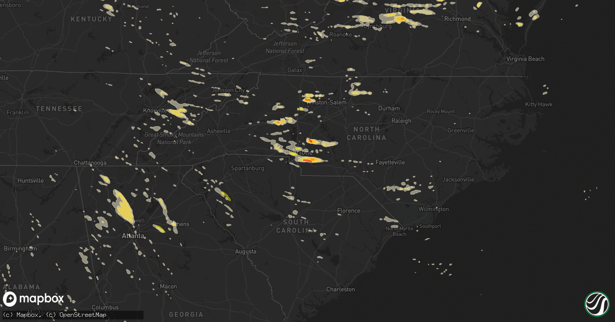
Hail Map on June 13, 2013
Get this storm
June 13 map
$229
one time, instant access
Download today. No call, no setup
Keep the $229
Bought the map and want the full workflow? Apply the entire $229 to a subscription within 7 days. None of it is wasted.
Every map, not just this one
This buys you this map. Subscription and you get every map we run, in the markets you choose from a few cities to whole states to nationwide. Plus real-time alerts the moment a storm fires.
Contact data
Name, contact info, occupancy, even credit band for addresses in the footprint. You go from where it hit to who to call.
Become the source they trust
Unlimited branding weather history reports on demand. You already have the documented answer ready for the property owner, and you are the one who showed up with it.
Property data and RoofTrace estimates
Pull up any address you have got, its value and the exact code rules for that jurisdiction, straight from One Click Code. Then RoofTrace estimates the squares, pitch, and roof value, priced the way you price.
States Impacted by Hail Map on June 13, 2013
Storm reports
Ohio
| Date | Description |
|---|---|
| 06/13/201310:10 AM CDT | 1 tree down |
| 06/13/201310:10 AM CDT | Rock spring road 1 tree down. |
| 06/13/20139:40 AM CDT | Several trees were downed in the area. |
| 06/13/20139:27 AM CDT | One tree was downed due to thudnerstorm winds. |
| 06/13/20138:39 AM CDT | One tree was downed in locust ridge due to thunderstorm winds. |
| 06/13/20138:30 AM CDT | Trees downed |
| 06/13/20138:10 AM CDT | A large tree fell and destroyed a wooden deck. |
| 06/13/20138:10 AM CDT | A large limb fell on a house. |
| 06/13/20138:10 AM CDT | Large limbs fell on a car. |
| 06/13/20138:00 AM CDT | Branches down. Arbor vitae blown over. |
| 06/13/20138:00 AM CDT | A large limb was downed. |
| 06/13/20137:57 AM CDT | One tree was downed and numerous other trees were damaged at losantiville country club. |
| 06/13/20137:57 AM CDT | A tractor trailer was blown over in roselawn near the intersection of reading road and losantiville avenue. Sections of roofing were blown off an apartment building acr |
| 06/13/20137:48 AM CDT | Large branch reported down. Time estimated from radar. |
| 06/13/20137:17 AM CDT | A tree was downed along dayton-farmersville road. |
Colorado
| Date | Description |
|---|---|
| 06/13/20136:53 PM CDT | Brief touchdown in open field with no damage reported. |
| 06/13/20136:41 PM CDT | A local report indicates 58 MPH wind near BURLINGTON |
| 06/13/20136:29 PM CDT | A local report indicates 58 MPH wind near FIRSTVIEW |
| 06/13/20136:20 PM CDT | Visibility zero in blowing dirt. From spotter network. |
| 06/13/20136:16 PM CDT | A local report indicates 58 MPH wind near BURLINGTON |
| 06/13/20136:16 PM CDT | A local report indicates 1.50 inch wind near 11 N BETHUNE |
| 06/13/20136:13 PM CDT | A local report indicates 1.75 inch wind near 18 N BETHUNE |
| 06/13/20136:12 PM CDT | 3 inch green tree limb down. Visibility near zero at times in blowing dust. |
| 06/13/20136:09 PM CDT | Several branches broke with one falling on a power pole |
| 06/13/20136:04 PM CDT | Asos recorded 62 mph gust at 504 pm. |
| 06/13/20136:00 PM CDT | A local report indicates 59 MPH wind near FLAGLER |
| 06/13/20134:30 PM CDT | Klhx asos |
| 06/13/20134:28 PM CDT | Tree branches down from strong winds. |
| 06/12/20138:29 PM CDT | 3 inch limbs down in peetz |
| 06/12/20137:32 PM CDT | Brief touchdown in open field |
| 06/12/20137:17 PM CDT | A local report indicates 66 MPH wind near AKRON |
| 06/12/20137:15 PM CDT | Brief touchdown in open field |
| 06/12/20137:14 PM CDT | A local report indicates 1.75 inch wind near 7 SSE WRAY |
Kentucky
| Date | Description |
|---|---|
| 06/13/201312:37 PM CDT | Trees down on highway 931s at cowan. |
| 06/13/201312:26 PM CDT | Tree down on clover ridge road. |
| 06/13/201312:25 PM CDT | A local report indicates 75 MPH wind near 3 E DORTON |
| 06/13/201312:21 PM CDT | 3 trees blown down along a driveway in blackey |
| 06/13/201312:20 PM CDT | Trees down on cutshin road. |
| 06/13/201312:20 PM CDT | Trees down on marrowbone creek. |
| 06/13/201312:20 PM CDT | Trees down on dorton creek road. |
| 06/13/201312:16 PM CDT | Tree down on highway 421. |
| 06/13/201312:16 PM CDT | Trees down on hwy 421 |
| 06/13/201311:58 AM CDT | Tree down on house at gulston. |
| 06/13/201311:58 AM CDT | Couple of trees down on highway 550 west of hindman. |
| 06/13/201311:58 AM CDT | Couple of trees down on highway 550 west of hindman. |
| 06/13/201311:58 AM CDT | Trees down on crawfish road. |
| 06/13/201311:54 AM CDT | Trees down on bullskin road at sizerock post office. |
| 06/13/201311:50 AM CDT | Couple of trees down on highway 2029 just off of highway 80. |
| 06/13/201311:45 AM CDT | A tree was blown on to a house trailer. |
| 06/13/201311:15 AM CDT | 3 trees blown down on property off of highway 30. |
| 06/13/201311:15 AM CDT | Tree across road on hwy 52 near the intersection of hwy 52 and hwy 30. |
| 06/13/201311:15 AM CDT | 1 tree blown down on property off highway 30. |
| 06/13/201310:41 AM CDT | Tree down partialy blocking mckee rd/ky 89 south. |
| 06/13/201310:35 AM CDT | Tree down and partially blocking stacy lane road. |
| 06/13/201310:35 AM CDT | Tree down and partially blocking trotting ridge road. |
| 06/13/201310:29 AM CDT | Large tree fell on two homes |
| 06/13/201310:26 AM CDT | Big tree limb down on white oak road in north irvine. |
| 06/13/201310:26 AM CDT | Tree down on east college ave. |
| 06/13/201310:25 AM CDT | A local report indicates 59 MPH wind near 3 E DORTON |
| 06/13/201310:22 AM CDT | Power lines down in harrodsburg. |
| 06/13/201310:17 AM CDT | Power lines and five power poles down partially blocking us hwy 127 |
| 06/13/201310:12 AM CDT | 100 foot pine tree down. |
| 06/13/201310:05 AM CDT | Trees down at sycamore and wynn streets and queen street and ocean ave. |
| 06/13/201310:00 AM CDT | Trees down at paris pike and highway 11. |
| 06/13/20139:45 AM CDT | Power line fell on a home |
| 06/13/20139:40 AM CDT | Roof damage to a barn |
| 06/13/20139:39 AM CDT | Downed power lines and power pole blocking the intersection of newtown pike and plantation drive |
| 06/13/20139:39 AM CDT | Downed power lines and power pole blocking the intersection of newtown pike and citation blvd |
| 06/13/20139:35 AM CDT | Trees down |
| 06/13/20139:25 AM CDT | Damage to a barn on allen pike |
| 06/13/20139:25 AM CDT | Trees down |
| 06/13/20139:00 AM CDT | Trees down |
| 06/13/20139:00 AM CDT | Power poles down on pleasureville road |
Delaware
| Date | Description |
|---|---|
| 06/13/20134:45 PM CDT | A local report indicates 68 MPH wind near FRANKFORD |
| 06/13/20134:30 PM CDT | Several trees uprooted including on north bradford street. |
| 06/13/20134:02 PM CDT | A local report indicates 68 MPH wind near FRANKFORD |
| 06/13/20139:47 AM CDT | Several trees were downed and one tree resting on house. One report of wires down. |
| 06/13/20139:15 AM CDT | Trees down over wires...similar damage in smyrna and hartly in kent county... De. |
| 06/13/20139:12 AM CDT | Numerous trees down...broken limbs...power outages |
| 06/13/20139:00 AM CDT | Several trees were downed and one tree resting on house. One report of wires down. |
| 06/13/20138:32 AM CDT | Single tree into power line |
| 06/13/20138:22 AM CDT | Numerous trees down...broken limbs...power outages |
| 06/13/20138:20 AM CDT | Single tree into power line |
South Carolina
| Date | Description |
|---|---|
| 06/13/20136:45 PM CDT | Tree down on sandshore drive |
| 06/13/20136:35 PM CDT | Tree down at sally white road |
| 06/13/20136:27 PM CDT | Observed along williamson hill rd. |
| 06/13/20136:13 PM CDT | A local report indicates 1.00 inch wind near HONEA PATH |
| 06/13/20135:22 PM CDT | Multiple trees blown down. |
| 06/13/20134:30 PM CDT | Tree down near grassy pond |
| 06/12/201310:20 PM CDT | Tree down in 100 block of n old georgetown rd - time estimated based on radar |
| 06/12/201310:15 PM CDT | Two trees down at white oak rd and cade rd - time estimated based on radar |
| 06/12/20139:44 PM CDT | Trees down at bethel church rd and cody rd |
| 06/12/20139:29 PM CDT | Trees down near interstate 20 close to mm 80 |
| 06/12/20138:55 PM CDT | Trees down along interstate 20 near mile marker 85 |
| 06/12/20138:20 PM CDT | Trees down on powerlines at intersection of wateree road and shangri-la drive |
| 06/12/20138:15 PM CDT | 1 tree down cromer rd and oak drive |
| 06/12/20137:00 PM CDT | Tree blown down. Time estimated from radar. |
Florida
| Date | Description |
|---|---|
| 06/13/20133:15 PM CDT | Power lines and tree down on south 7th street in macclenny. One person injured by falling tree. |
| 06/13/20132:50 PM CDT | Numerous large limbs and a few small trees down in fort caroline. Time estimated based on radar. |
Kansas
| Date | Description |
|---|---|
| 06/12/20137:43 PM CDT | A local report indicates 60 MPH wind near 3 S GOODLAND |
Texas
| Date | Description |
|---|---|
| 06/13/20136:10 PM CDT | Large limbs down. Some trees uprooted. |
| 06/13/20133:23 PM CDT | Partial collapse of building under construction. Winds were gusting at khyi to 46mph around this time. |
North Carolina
| Date | Description |
|---|---|
| 06/13/20136:45 PM CDT | Bladen co e.m. Reported tree down 2 mi nw of ammon - time estimated based on radar |
| 06/13/20136:45 PM CDT | Tideland electric coop reported a tree down on railroad bed road. Time based on radar. |
| 06/13/20136:33 PM CDT | A local report indicates 62 MPH wind near ELIZABETH CITY BEACH |
| 06/13/20136:31 PM CDT | Bladen co. 911 reported tree down on fl mcdaniel road - time estimated based on radar |
| 06/13/20136:30 PM CDT | Numerous trees down county-wide. Hardest hit area was clinton. |
| 06/13/20136:24 PM CDT | A local report indicates 65 MPH wind near ELIZABETH CITY |
| 06/13/20136:19 PM CDT | Greens cross raws...time estimated from radar. |
| 06/13/20136:11 PM CDT | Powerlines down on green haynes rd |
| 06/13/20136:11 PM CDT | Tree down on kelly rd and fallen creek rd |
| 06/13/20136:05 PM CDT | Tree down btw pine bush rd and sutton rd |
| 06/13/20136:03 PM CDT | Minor structural damage to farm...multiple trees snapped and uprooted |
| 06/13/20136:00 PM CDT | Trees blown down across camden road |
| 06/13/20135:58 PM CDT | Peak wind 61 mph at kfbg. |
| 06/13/20135:51 PM CDT | A local report indicates 61 MPH wind near FT BRAGG SIMMONS AAF |
| 06/13/20135:49 PM CDT | Tree down along aberdeen road |
| 06/13/20135:49 PM CDT | Power lines down at mcintosh and mclaughlin roads. |
| 06/13/20135:49 PM CDT | A local report indicates 60 MPH wind near 1 ENE MOUNT OLIVE |
| 06/13/20135:45 PM CDT | Large pecan tree 2ft diameter down with minor structural damage to residence. |
| 06/13/20135:45 PM CDT | Numerous trees and power lines blown down...especially across the north half of the county |
| 06/13/20135:40 PM CDT | Multiple trees snapped |
| 06/13/20135:40 PM CDT | Multiple trees snapped between wahlstonburg and stantonsburg |
| 06/13/20135:40 PM CDT | Roof damage and chimney blown off of a home |
| 06/13/20135:36 PM CDT | Several trees blown down in raeford |
| 06/13/20135:35 PM CDT | Trees down near goldsboro |
| 06/13/20135:35 PM CDT | Numerous trees and power lines blown down...especially across the north half of the county |
| 06/13/20135:30 PM CDT | Numerous trees downed in colerain along elm grove rd. |
| 06/13/20135:26 PM CDT | Trees down near fremont |
| 06/13/20135:25 PM CDT | Numerous trees blown down especially over the south half of the county |
| 06/13/20135:23 PM CDT | A local report indicates 1.00 inch wind near STALLINGS |
| 06/13/20135:23 PM CDT | 4 power poles down on railroad tracks |
| 06/13/20135:21 PM CDT | Peak wind of 59 mph at krwi |
| 06/13/20135:21 PM CDT | Along ryals street |
| 06/13/20135:20 PM CDT | Tree blown down across rains crossroads road near princeton-kenly road |
| 06/13/20135:20 PM CDT | Numerous trees and power lines were reported down across the county. |
| 06/13/20135:20 PM CDT | Exterior metal door frame damaged at nash community college in rocky mount |
| 06/13/20135:16 PM CDT | Trees down near ranch road |
| 06/13/20135:15 PM CDT | Numerous trees down in laurinburg and wagram. |
| 06/13/20135:15 PM CDT | A local report indicates 1.75 inch wind near 4 N MONROE |
| 06/13/20135:15 PM CDT | Multiple trees blown down near highway 210 and old fairgrounds road |
| 06/13/20135:15 PM CDT | Widespread area of trees down and trees on houses in unionville. |
| 06/13/20135:14 PM CDT | A local report indicates 1.00 inch wind near 13 N MONROE |
| 06/13/20135:14 PM CDT | Estimated 50 mph wind. |
| 06/13/20135:13 PM CDT | A local report indicates 1.25 inch wind near INDIAN TRAIL |
| 06/13/20135:10 PM CDT | Telephone pole blocking roadway with large tree limb knocking down a powerline |
| 06/13/20135:10 PM CDT | Tin roof blown off smithfield pre own car dealership |
| 06/13/20135:10 PM CDT | Trees down across crantock road in clayton |
| 06/13/20135:08 PM CDT | 10 inch diameter tree has pulled down powerline partially blocking hwy 39. |
| 06/13/20135:07 PM CDT | 35-foot tall tree partially uprooted and on a house...plus a 20-foot branch blown down. Another tree landed on and severely damaged a mobile home. |
| 06/13/20135:06 PM CDT | Observed along lawyers road. |
| 06/13/20135:06 PM CDT | Several trees and tree limbs down on 100 lynn hils drive near richardson road and hwy 231 |
| 06/13/20135:05 PM CDT | Tree down at mccormick drive and buffalo road |
| 06/13/20135:05 PM CDT | Several trees blown down |
| 06/13/20135:05 PM CDT | Tree down in a yard |
| 06/13/20135:02 PM CDT | Tree down on power lines |
| 06/13/20135:00 PM CDT | Oak tree blown down and power lines blown down along cross street. Time estimated. |
| 06/13/20135:00 PM CDT | Tree down |
| 06/13/20135:00 PM CDT | Large tree limbs blown down along indian creek trail |
| 06/13/20135:00 PM CDT | Powerlines blown down across the road |
| 06/13/20135:00 PM CDT | Power lines down on road |
| 06/13/20135:00 PM CDT | Tree down on finch avenue |
| 06/13/20135:00 PM CDT | Several trees down and blocking roadway. |
| 06/13/20135:00 PM CDT | Forty-foot tree blown down on second street |
| 06/13/20135:00 PM CDT | Railraod traffic signal arms have broken at hwy 42 east and business 70. |
| 06/13/20135:00 PM CDT | Tree uprooted |
| 06/13/20134:58 PM CDT | Two hardwood trees blown down |
| 06/13/20134:58 PM CDT | Pine tree and large limbs blown down along air park drive near highway 401 |
| 06/13/20134:57 PM CDT | Downed trees and power lines with trees on houses across troy |
| 06/13/20134:56 PM CDT | Trees down on guy road and route 42 west |
| 06/13/20134:56 PM CDT | Trees down on powerlines at business 70 and town center blvd in clayton |
| 06/13/20134:55 PM CDT | Scattered trees blown down |
| 06/13/20134:55 PM CDT | Trees down on powerlines at business 70 and town center blvd in clayton |
| 06/13/20134:55 PM CDT | Tree down near wendell |
| 06/13/20134:51 PM CDT | Two trees blown down at buffaloe road and william and mary drive |
| 06/13/20134:51 PM CDT | Trees down on rocky fort road |
| 06/13/20134:51 PM CDT | Numerous trees down across the road at rawls church road and kennebeck road |
| 06/13/20134:50 PM CDT | Large oak tree blown down on bluebird court and jones franklin road |
| 06/13/20134:50 PM CDT | Trees blown down around lake tillery. |
| 06/13/20134:50 PM CDT | Trees down on guy road and route 42 west |
| 06/13/20134:50 PM CDT | Twenty-foot tall tree blown down. Time estimated. |
| 06/13/20134:50 PM CDT | Tree blown down along gregory drive |
| 06/13/20134:50 PM CDT | Tree blown down and blocking road at mitchell mill and watkins roads |
| 06/13/20134:50 PM CDT | Power lines and large tree blown down on glenwood road near five points |
| 06/13/20134:49 PM CDT | 2 trees sheared off and a half dozen down around the neighborhood near 165 bayberry woods drive |
| 06/13/20134:49 PM CDT | Tree down at 4800 shoshoni court in garner |
| 06/13/20134:49 PM CDT | Pine tree blown down and blocking highway 55 eastbound near carpenter fire station road |
| 06/13/20134:47 PM CDT | Roof of industrial carport collapsed at pruitt lumber co. Trees and power lines down across the area. |
| 06/13/20134:47 PM CDT | Trees down and on powerlines in lee county on hickory avenue near sanford |
| 06/13/20134:47 PM CDT | Tree down on a house on old stage road |
| 06/13/20134:47 PM CDT | Tree down |
| 06/13/20134:45 PM CDT | Quarter size hail on woodlawn road. |
| 06/13/20134:45 PM CDT | Multiple trees down near lake tillery |
| 06/13/20134:45 PM CDT | Large maple tree blown down on home |
| 06/13/20134:45 PM CDT | 30-foot tall tree blown down along jones franklin road |
| 06/13/20134:45 PM CDT | Snapped tree on power lines at fayetteville and manor ridge road. |
| 06/13/20134:45 PM CDT | Trees uprooted |
| 06/13/20134:45 PM CDT | Tree and large limbs blown down |
| 06/13/20134:43 PM CDT | Five 20-24 inch diameter trees down at ten-ten road and deer meadow drive |
| 06/13/20134:43 PM CDT | Multiple trees down on lake wheeler road |
| 06/13/20134:42 PM CDT | Multiple trees down in the franklinton area |
| 06/13/20134:42 PM CDT | 8 to 12 inch diameter tree down. |
| 06/13/20134:42 PM CDT | Scattered trees blown down and power outages |
| 06/13/20134:41 PM CDT | A local report indicates 1.75 inch wind near 1 S CONCORD |
| 06/13/20134:40 PM CDT | Trees down on deberry mill rd |
| 06/13/20134:40 PM CDT | Tree blown down on a power line near lumley road and interstate 540 |
| 06/13/20134:40 PM CDT | *** 3 inj *** county emergency manager reports numerous trees down county-wide. Albemarle hardest hit. Numerous trees blown down on homes...several of which went throug |
| 06/13/20134:40 PM CDT | Dispatch reported 2 trees downed across the county. |
| 06/13/20134:40 PM CDT | A local report indicates 63 MPH wind near 5 SSW ROLESVILLE |
| 06/13/20134:38 PM CDT | Trees down on rocky fort road |
| 06/13/20134:38 PM CDT | Tree split in half across the intersection of rex way and lake boone trail |
| 06/13/20134:38 PM CDT | Tree down |
| 06/13/20134:38 PM CDT | Tree across greystone road in henderson |
| 06/13/20134:36 PM CDT | Tree down and roof blown off a mobile home |
| 06/13/20134:35 PM CDT | Four-foot diameter tree...60 feet high...blown down |
| 06/13/20134:33 PM CDT | Multiple trees down in the centerville area |
| 06/13/20134:32 PM CDT | Multiple trees blown down at carpenter fire station road and highway 55 |
| 06/13/20134:32 PM CDT | At least one tree blown down at apex community park |
| 06/13/20134:32 PM CDT | Powerlines across twin creek road in apex. |
| 06/13/20134:32 PM CDT | Tree blown down along ymca drive. Time estimated based on earlier reports. |
| 06/13/20134:32 PM CDT | Several large limbs blown down |
| 06/13/20134:32 PM CDT | Trees blown down along cameron pond drive |
| 06/13/20134:32 PM CDT | Trees down and on powerlines in lee county on hickory avenue near sanford |
| 06/13/20134:30 PM CDT | 18 in. Diameter... 30 ft tall maple sheared off 5 ft from ground on walcott way in cary |
| 06/13/20134:30 PM CDT | Powerline down near davis and caviston in morrisville |
| 06/13/20134:26 PM CDT | Several large branches blown down and pwr outages. |
| 06/13/20134:25 PM CDT | 8 trees down at central regional hospital in butner |
| 06/13/20134:25 PM CDT | Many trees down countywide |
| 06/13/20134:22 PM CDT | Tree through a house along morningside dr. |
| 06/13/20134:20 PM CDT | *** 1 inj *** tree blown down on franklin street. |
| 06/13/20134:20 PM CDT | Large poplar tree snapped and fell on fence in autumn acres. |
| 06/13/20134:20 PM CDT | Numerous trees down near the preserve |
| 06/13/20134:20 PM CDT | Multiple reports of trees and utility lines down...some on cars and houses...across concord. |
| 06/13/20134:20 PM CDT | Multiple trees reported down in the northeastern portion of chatham county |
| 06/13/20134:18 PM CDT | Trees down along durham lane. |
| 06/13/20134:18 PM CDT | Multiple trees down around the pittsboro area |
| 06/13/20134:17 PM CDT | Pine tree blown down on highway 98 and olive branch road |
| 06/13/20134:15 PM CDT | *** 1 fatal *** a large tree was blown down on the 300 block of east franklin street killing a 20 year old female. |
| 06/13/20134:11 PM CDT | Numerous trees and power lines blown down along red mountain road |
| 06/13/20134:11 PM CDT | A local report indicates 70 MPH wind near ROUGEMONT |
| 06/13/20134:10 PM CDT | Large tree and power lines blown down along hampton road |
| 06/13/20134:10 PM CDT | Concord airport |
| 06/13/20134:05 PM CDT | Scattered trees blown down along hurdle mills road |
| 06/13/20134:05 PM CDT | Numerous trees and power lines down across northern vance county |
| 06/13/20134:00 PM CDT | Multiple trees reported down in and around siler city |
| 06/13/20134:00 PM CDT | Large limbs blown down at carr elementary school and at trade and walnut streets. |
| 06/13/20133:59 PM CDT | Observed along hwy 321 and radio st |
| 06/13/20133:58 PM CDT | 2 power poles down |
| 06/13/20133:58 PM CDT | A roof and a porch were blown off of a home near prospect hill. Caswell warning point also reported 100s of trees down across the county between 430 and 500 pm...the ex |
| 06/13/20133:58 PM CDT | Several large trees down |
| 06/13/20133:55 PM CDT | Five 12 to 14 inch diameter trees down |
| 06/13/20133:54 PM CDT | Tree down |
| 06/13/20133:54 PM CDT | Trees down on homes... Front porch steps ripped off |
| 06/13/20133:52 PM CDT | Trees down along lorey farm road. |
| 06/13/20133:50 PM CDT | Many trees down around the roxboro area |
| 06/13/20133:50 PM CDT | Trees down |
| 06/13/20133:50 PM CDT | Tree on house on parkview circle |
| 06/13/20133:48 PM CDT | Scattered trees blown down |
| 06/13/20133:46 PM CDT | Trees down. |
| 06/13/20133:46 PM CDT | Trees down. |
| 06/13/20133:45 PM CDT | Numerous reports of trees down across the county. |
| 06/13/20133:45 PM CDT | Large tree downed onto a home on nutcracker lane |
| 06/13/20133:45 PM CDT | A couple trees down in rockwell. |
| 06/13/20133:42 PM CDT | Tree down across bear poplar road. |
| 06/13/20133:40 PM CDT | Widespread trees down across the entire county |
| 06/13/20133:36 PM CDT | Multiple trees down |
| 06/13/20133:35 PM CDT | Trees down. |
| 06/13/20133:30 PM CDT | Numerous trees down across the northern part of the county. Highway 29 and highway 86 were blocked in several places by fallen trees. Motorists were stranded in their v |
| 06/13/20133:27 PM CDT | Trees snapped and uprooted. |
| 06/13/20133:26 PM CDT | 3 trees down near browns summit |
| 06/13/20133:25 PM CDT | Tree on house. |
| 06/13/20133:21 PM CDT | Tree down... Time estimated by radar |
| 06/13/20133:20 PM CDT | Multiple trees down... Including one on a transformer |
| 06/13/20133:20 PM CDT | Scattered trees down across the county...especially north-central part. |
| 06/13/20133:20 PM CDT | Lxfn7 raws reported wind gust to 64 mph. |
| 06/13/20133:15 PM CDT | Trees down along hunter pond lane. |
| 06/13/20133:15 PM CDT | Forsyth co reports damage county wide... Many trees and power lines down... Worst is in the northwest. |
| 06/13/20133:15 PM CDT | Widespread wind damage countywide. 83 reports of downed trees and powerlines. 7400 customers without power across the county. Wind reports began around 350 pm in the no |
| 06/13/20133:15 PM CDT | Newspaper reported numerous trees blown down in the big creek area of the great smoky mountains. Several trails have been closed due to being impassable. Possible torna |
| 06/13/20133:15 PM CDT | Trees down on i-40...traffic was stopped. |
| 06/13/20133:12 PM CDT | 2 trees down at weather ridge road and weather ridge ct |
| 06/13/20133:12 PM CDT | Several large limbs blown down in statesville. |
| 06/13/20133:11 PM CDT | Trees down. |
| 06/13/20133:10 PM CDT | Numerous trees reported down on west side of statesville. |
| 06/13/20133:10 PM CDT | Multiple trees down off hwy 70.awnings and siding torn off houses. |
| 06/13/20133:10 PM CDT | Nws storm survey found part of an ef1 tornado track in the big creek area of the great smoky mountains national park. See caepnsgsp for details. |
| 06/13/20133:07 PM CDT | Trees downed and snapped along taylorsville rd. |
| 06/13/20133:07 PM CDT | Tree down on a house... People trapped inside |
| 06/13/20133:06 PM CDT | Numerous trees were blown down in the lecho park sub-division near thornburg dr and rock barn rd. One home was destroyed and others were damaged by fallen trees. |
| 06/13/20133:05 PM CDT | Up to 1 inch hail in sheffield. |
| 06/13/20133:04 PM CDT | Tree down on sixth street |
| 06/13/20133:03 PM CDT | Reports of golf ball sized hail along county home road on the north side of conover. |
| 06/13/20133:02 PM CDT | Trees down on route 700. |
| 06/13/20133:02 PM CDT | County home road was declared a catastrophy area by an insurance company due to numerous trees down with some trees on houses. A brick chimney was blown over onto a hou |
| 06/13/20133:02 PM CDT | Dozen trees down. One fell on a house. |
| 06/13/20133:00 PM CDT | Damage to a shed... Hurricane straps were snapped. Time estimated by radar. |
| 06/13/20132:58 PM CDT | 1 inch hail and strong wind gusts. |
| 06/13/20132:56 PM CDT | 50 knot wind gust recorded at int |
| 06/13/20132:55 PM CDT | Trees down in boone. |
| 06/13/20132:48 PM CDT | Numerous reports of trees down at 1610 bright leaf road in pfafftown. |
| 06/13/20132:46 PM CDT | Trees down along cape hickory rd |
| 06/13/20132:46 PM CDT | A local report indicates 59 MPH wind near LONGVIEW |
| 06/13/20132:45 PM CDT | Also trees down on gap lane |
| 06/13/20132:41 PM CDT | Several trees blown down. |
| 06/13/20132:39 PM CDT | 1 inch hail and strong wind gusts reported in drexel. |
| 06/13/20132:39 PM CDT | Power lines down along drexel rd. |
| 06/13/20132:38 PM CDT | A local report indicates 1.00 inch wind near YADKINVILLE |
| 06/13/20132:38 PM CDT | Trees down on four houses. |
| 06/13/20132:35 PM CDT | Some damage to cars |
| 06/13/20132:35 PM CDT | A local report indicates 1.00 inch wind near N YADKINVILLE |
| 06/13/20132:30 PM CDT | Trees down off st marys church rd and hwy 181. |
| 06/13/20132:30 PM CDT | Several reports of trees and utility lines down...some on houses...countywide. |
| 06/13/20132:22 PM CDT | 50-100 trees down along pleasant hill drive and blue ridge avenue in pleasant hill. Winds estimated 60 mph for 2-3 minutes. |
| 06/13/20132:20 PM CDT | Trees down off packs hill road north of morganton. |
| 06/13/20132:19 PM CDT | *** 1 fatal *** firefighter electrocuted by a downed powerline. |
| 06/13/20132:18 PM CDT | Numerous trees and powerlines down in elkin area |
| 06/13/20132:15 PM CDT | At 1124 bethany ford rd large trees and limbs down |
| 06/13/20132:15 PM CDT | 2 trees down |
| 06/13/20132:07 PM CDT | *** 1 fatal *** tree fell on an elderly man as he walked across his yard. |
| 06/13/20131:56 PM CDT | One tree reported down off hwy 80 east of bakersville. |
| 06/13/20131:50 PM CDT | Tree down |
| 06/13/20131:50 PM CDT | 2 trees down on deep ford rd |
| 06/13/20131:50 PM CDT | Tree down at rec center |
| 06/13/20131:48 PM CDT | Two trees down near laurel. |
| 06/13/20131:41 PM CDT | One tree reported down in maggie valley. |
| 06/13/20131:35 PM CDT | Tree down on cutshall road |
| 06/12/201311:45 PM CDT | Intersection of longwood rd and etheridge rd |
| 06/12/201310:00 PM CDT | Large tree across road near long creek fire dept - time estimated based on radar |
| 06/12/20139:40 PM CDT | Boykin bridge road briefly closed due to downed trees across the road |
| 06/12/20139:34 PM CDT | Report of half dollar sized hail on harrelson rd. |
| 06/12/20138:30 PM CDT | Tree down at us hwy 301 and w green springs rd - time estimated based on radar |
| 06/12/20137:48 PM CDT | One large tree was reported down across strother road... Near ashemont road. |
| 06/12/20137:45 PM CDT | Tree blown down on a house. Time based on radar. |
| 06/12/20137:22 PM CDT | Tree down on power line reported at hwy 11 and red tip ln - time estimated based on radar |
| 06/12/20137:10 PM CDT | Half dollar size hail reported at gibson dairy rd and mercer mill rd - time estimated based on radar |
| 06/12/20137:05 PM CDT | Quarter to half dollar size hail reported at us hwy 701 and harrelson rd - time estimated based on radar |
Mississippi
| Date | Description |
|---|---|
| 06/13/201312:40 AM CDT | Several trees were blown down around shubuta. Power outages in the beaver dam and harmony communities of southern clark county. |
| 06/13/201312:39 AM CDT | Power outages were observed from blown down power lines from areas around shubuta. |
| 06/12/20137:50 PM CDT | Reports of a few powerlines down with one on highway 45 and another on hunters hollow. |
Georgia
| Date | Description |
|---|---|
| 06/13/20136:51 PM CDT | Several large trees are down near north ridge and roswell roads. |
| 06/13/20136:50 PM CDT | This wind was recorded at peachtree dekalb airport. |
| 06/13/20136:50 PM CDT | Several trees are down across sandy springs. |
| 06/13/20136:50 PM CDT | Clarke county 911 reports over 30 trees are down county wide. . |
| 06/13/20136:45 PM CDT | Public reports 2 foot wide tree snapped off in their yard. |
| 06/13/20136:45 PM CDT | Three 15 year old trees came down near southwick and ethridge drive. A nearby home had its shutters blown off by the wind. |
| 06/13/20136:41 PM CDT | The tornado that moved through cherokee and cobb counties tracked into fulton county at the chattahoochee river near johnson ferry road and riverside drive. The tornado |
| 06/13/20136:40 PM CDT | Several trees snapped and uprooted in the area of kennesaw state university. |
| 06/13/20136:35 PM CDT | Numerous trees and powerlines were reported down county wide by the 911 center. |
| 06/13/20136:30 PM CDT | The tornado that touched down just inside the cherokee county line moved into cobb county and strengthened to an ef-1. The tornado tracked southeast through cobb county |
| 06/13/20136:30 PM CDT | An nws survey team determined that a second tornado touched down within a tenth of a mile of the cherokee-cobb county line just inside the cherokee county line along wo |
| 06/13/20136:27 PM CDT | Several large trees across barrow county are down per ema. |
| 06/13/20136:22 PM CDT | *** 2 inj *** cherokee em reports 2 non life threatening injuries due to downed trees in the town of canton. |
| 06/13/20136:17 PM CDT | A large number of trees are down on homes...cars...and powerlines. There are a number of power outages. |
| 06/13/20136:15 PM CDT | The 911 center reported numerous trees down in the town of white. |
| 06/13/20136:10 PM CDT | A tree was reported down 7 miles north of canton. |
| 06/13/20136:03 PM CDT | Tv media passed along a 59 mph wind gust from a viewers davis weather station. |
| 06/13/20136:00 PM CDT | The tornado touched down near the intersection of patriot trail and rampley trail...causing tree damage as it headed south towards canton. Along marietta rd and hickory |
| 06/13/20135:36 PM CDT | The 911 center reported many trees were down across the county and especially to the northeast of dahlonega. |
| 06/13/20135:25 PM CDT | The public reported an estimated wind gust in downtown dahlonega of 60 mph. Some tree limbs were down. |
| 06/13/20135:25 PM CDT | Several trees were reported down in the southwest part of the county. |
| 06/13/20135:25 PM CDT | Numerous trees and powerlines were reported down across the county including a few along high 61. |
| 06/13/20135:12 PM CDT | Trees down. One on a house. |
| 06/13/20135:05 PM CDT | The 911 center reported numerous trees and powerlines down along highway 60 in the south part of the county. |
| 06/13/20134:55 PM CDT | Multiple trees and powerlines down near lake burton. |
| 06/13/20134:54 PM CDT | Local 911 reported that trees were down countywide with many taking down power lines. |
| 06/13/20134:49 PM CDT | Several trees were reported down in the southwest part of the county. |
| 06/13/20134:45 PM CDT | Numerous trees down across the county particularly hiawassee area. |
| 06/13/20134:43 PM CDT | Two trees downed just north of downtown dalton near n thorton ave and w tyler st |
| 06/12/20139:30 PM CDT | Several trees were reported down by the 911 center with a few each at mlk road and 8th street. |
| 06/12/20138:55 PM CDT | A couple of trees reported down across macon. |
| 06/12/20138:30 PM CDT | Around a dozen trees were reported down across the county including several along highway 29 and a few more along highway 34 west. One tree was also reported on a house |
| 06/12/20138:22 PM CDT | Several trees reported down county wide. |
| 06/12/20137:59 PM CDT | Several trees are reported down across shiloh road and highway 42. |
| 06/12/20137:36 PM CDT | Several trees are reported down on huey road...hillside drive and reynolds road. Some power outages reported. |
| 06/12/20137:35 PM CDT | Numerous trees and powerlines were reported down by the 911 center from jonesboro southward through the panhandle of clayton county. |
| 06/12/20137:10 PM CDT | Public reported 1 inch hail. |
| 06/12/20137:04 PM CDT | Bobo road is closed due to several trees wtih power lines down across the road. |
| 06/12/20137:00 PM CDT | Tree down on atlanta highway |
| 06/12/20137:00 PM CDT | A local report indicates 1.00 inch wind near CEDARTOWN |
| 06/12/20137:00 PM CDT | Trees snapped and uprooted across bolton road between marietta blvd and road. Power lines and lines down also. |
Nebraska
| Date | Description |
|---|---|
| 06/12/20139:12 PM CDT | Windspeeds around 70 mph 12 north of big springs. |
| 06/12/20138:46 PM CDT | Delayed report. Estimated wind in excess of 60 mph. Damage to outbuildings and pole barns. |
| 06/12/20138:44 PM CDT | 60 mph winds reported with nickle size hail. |
| 06/12/20138:40 PM CDT | Estimated 70 mph wind blew over a tractor trailer on i-80. |
| 06/12/20138:40 PM CDT | Estimated 60 mph wind blew over a tractor trailer on i-80. |
Montana
| Date | Description |
|---|---|
| 06/13/20136:55 PM CDT | A local report indicates 1.75 inch wind near 10 NE REED POINT |
| 06/13/20136:40 PM CDT | 50 to 60 mph wind gusts and hail up to quarter size. Second storm in same location one hour after the first. |
| 06/13/20136:40 PM CDT | Quarter size hail and wind gusts to 60 mph. Second storm in same location an hour after the first. |
| 06/13/20136:35 PM CDT | A local report indicates 1.75 inch wind near 10 NE REED POINT |
| 06/13/20136:35 PM CDT | A local report indicates 2.50 inch wind near 12 WNW RAPELJE |
| 06/13/20136:15 PM CDT | A local report indicates 1.00 inch wind near SE WILSALL |
| 06/13/20136:15 PM CDT | A local report indicates 60 MPH wind near 19 ENE BIG TIMBER |
| 06/13/20135:40 PM CDT | Hail up to the size of quarters and 50 to 60 mph winds. |
| 06/13/20135:40 PM CDT | 50 to 60 mph gusts accompanied by hail up to quarter size. |
| 06/13/20135:40 PM CDT | A local report indicates 1.75 inch wind near 18 NW BIG TIMBER |
| 06/13/20135:25 PM CDT | A local report indicates 1.00 inch wind near 8 NW SPRINGDALE |
| 06/13/20133:40 PM CDT | Quarter size hail. |
| 06/13/201312:45 PM CDT | Thunderstorm wind gusts up to 60 mph with pea to dime size hail in the northwest part of the billings heights. |
| 06/13/201312:40 PM CDT | Half dollar size hail driven by thunderstorm winds up to 70 mph. |
| 06/13/201312:40 PM CDT | Thunderstorm wind gusts up to 70 mph driving half dollar size hail. |
| 06/13/201312:38 PM CDT | Gusts estimated at 60 mph with golf ball size hail in the northwest side of billings. |
| 06/13/201312:38 PM CDT | Golf ball size hail with thunderstorm wind gusts estimated at 60 mph on the northwest side of billings. |
| 06/13/201312:37 PM CDT | Quarter size hail. |
| 06/13/201312:12 PM CDT | A local report indicates 58 MPH wind near 6 E COLUMBUS |
| 06/13/20135:09 AM CDT | 6 inch limbs of trees down in sporadic locations in miles city. |
| 06/13/20131:49 AM CDT | 6 inch limbs of trees down in sporadic locations in miles city. |
| 06/13/20131:10 AM CDT | Cow creek raws |
| 06/13/201312:40 AM CDT | Badger peak raws |
| 06/12/201311:50 PM CDT | Wolf mountain raws |
| 06/12/201310:40 PM CDT | A local report indicates 1.00 inch wind near 1 E JOLIET |
| 06/12/20139:58 PM CDT | A local report indicates 1.00 inch wind near 6 SE JORDAN |
| 06/12/20139:30 PM CDT | A local report indicates 1.00 inch wind near NNW ROUNDUP |
| 06/12/20139:05 PM CDT | A local report indicates 1.00 inch wind near SSW LAVINA |
| 06/12/20139:05 PM CDT | Hail fell from 755pm to 805pm |
| 06/12/20138:30 PM CDT | A local report indicates 1.25 inch wind near 5 S RYEGATE |
| 06/12/20138:24 PM CDT | Delayed report from thursday...june 13th...2013. Half dollar size hail. |
| 06/12/20138:15 PM CDT | A local report indicates 1.75 inch wind near 16 S DELPHIA |
| 06/12/20138:00 PM CDT | A local report indicates 1.00 inch wind near 11 SSE ROUNDUP |
| 06/12/20137:40 PM CDT | Quarter size hail with 0.40 rainfall in 15 minutes and 40 mph winds |
| 06/12/20137:40 PM CDT | A local report indicates 2.00 inch wind near 11 ESE LAVINA |
| 06/12/20137:30 PM CDT | A local report indicates 1.75 inch wind near 13 SSW KLEIN |
| 06/12/20137:25 PM CDT | A local report indicates 1.50 inch wind near N BROADVIEW |
| 06/12/20137:20 PM CDT | A local report indicates 1.00 inch wind near 8 NW SPRINGDALE |
| 06/12/20137:10 PM CDT | A local report indicates 1.75 inch wind near 1 NE BELFRY |
| 06/12/20137:10 PM CDT | A local report indicates 1.00 inch wind near 4 E BELMONT |
Tennessee
| Date | Description |
|---|---|
| 06/13/20134:30 PM CDT | Dispatch reported 2 to 3 trees downed across the county. |
| 06/13/20133:15 PM CDT | Several trees down on highway 321 near baxter rd. |
| 06/13/20133:00 PM CDT | Trees down near seymour |
| 06/13/20133:00 PM CDT | Trees down near unicoi |
| 06/13/20132:55 PM CDT | The nws storm survey team concluded that an ef-1 tornado tracked across eastern sevier county on the 13th of june. It formed 14.1 miles ese of sevierville and lifted 14 |
| 06/13/20132:40 PM CDT | A local report indicates 70 MPH wind near NEWPORT |
| 06/13/20132:12 PM CDT | Trees reported down across the road near the intersection of hwy 111 and hwy 70 in sparta |
| 06/13/20132:11 PM CDT | The nws storm survey team concluded that an ef-1 tornado tracked across jefferson county on the 13th of june. It formed 4.7 miles nw of new market and lifted 3.1 miles |
| 06/13/20132:00 PM CDT | Trees down. |
| 06/13/20132:00 PM CDT | Numerous trees down in the luttrell area. |
| 06/13/20131:50 PM CDT | A few trees down county-wide. |
| 06/13/20131:42 PM CDT | Trees and power lines down county-wide |
| 06/13/20131:40 PM CDT | Trees down |
| 06/13/20131:35 PM CDT | Trees down county-wide. |
| 06/13/20131:30 PM CDT | A few trees down near jellico. |
| 06/13/20131:05 PM CDT | Trees down. |
| 06/13/20131:00 PM CDT | Trees down. |
| 06/13/201312:58 PM CDT | Several trees down in the white pine area. |
| 06/13/201312:46 PM CDT | Power lines and trees down in kingsport. |
| 06/13/201312:13 PM CDT | A few trees down 2 east of sneedville |
Wyoming
| Date | Description |
|---|---|
| 06/13/20135:14 PM CDT | Some tree limbs down |
| 06/13/20134:50 PM CDT | Damage to vehicle |
| 06/13/20134:42 PM CDT | A local report indicates 1.50 inch wind near 10 NNE SHERIDAN |
| 06/13/20134:36 PM CDT | A local report indicates 1.75 inch wind near 8 NE SHERIDAN |
| 06/13/20134:30 PM CDT | A local report indicates 1.50 inch wind near 2 N SHERIDAN |
| 06/13/20134:30 PM CDT | A local report indicates 1.75 inch wind near 3 N SHERIDAN |
| 06/13/20134:30 PM CDT | A local report indicates 1.75 inch wind near 1 NW SHERIDAN |
| 06/13/20134:26 PM CDT | Receiving golf ball and ping pong size hail |
| 06/13/20134:20 PM CDT | A local report indicates 1.25 inch wind near 6 WSW SHERIDAN |
| 06/13/20133:00 PM CDT | A local report indicates 1.00 inch wind near 1 ENE GREYBULL |
| 06/13/20132:25 PM CDT | Recorded by wydot sensor |
| 06/13/20131:54 PM CDT | A local report indicates 63 MPH wind near LANDER |
| 06/12/201311:59 PM CDT | A local report indicates 59 MPH wind near COWLEY |
| 06/12/201311:15 PM CDT | A local report indicates 1.00 inch wind near MEETEETSE |
| 06/12/20137:20 PM CDT | Peas to quarter sized hail |
Virginia
| Date | Description |
|---|---|
| 06/13/20135:01 PM CDT | Large tree limbs downed on wildwood dr |
| 06/13/20134:56 PM CDT | Numerous trees on homes across va beach. Numerous power lines down across the city. |
| 06/13/20134:54 PM CDT | Person blown off a pier at gloucester on the york river. Person was missing. |
| 06/13/20134:53 PM CDT | Trees blow into power lines along meadow creek lane. |
| 06/13/20134:50 PM CDT | Large limbs off top of tree down on roof |
| 06/13/20134:50 PM CDT | Large tree limbs downed on wildwood dr |
| 06/13/20134:50 PM CDT | Trees down along route 17. |
| 06/13/20134:44 PM CDT | A local report indicates 62 MPH wind near NORFOLK NAS |
| 06/13/20134:44 PM CDT | Estimated 60 mph wnds at the coal piers resulted in thick blowing coal dust reducing visibility to near zero along the monitor merrimac bridge tunnel. |
| 06/13/20134:40 PM CDT | Trees down along mercury blvd |
| 06/13/20134:40 PM CDT | Trees down and a billboard blown over near exit four along i-95. |
| 06/13/20134:40 PM CDT | House under construction was destroyed in ocean view. |
| 06/13/20134:38 PM CDT | Lafayette river weatherflow site |
| 06/13/20134:32 PM CDT | A local report indicates 62 MPH wind near NORFOLK NAS |
| 06/13/20134:30 PM CDT | Trees down across the county. |
| 06/13/20134:30 PM CDT | A local report indicates 62 MPH wind near HOLIDAY PARK |
| 06/13/20134:28 PM CDT | Trees on a house at weirwood. |
| 06/13/20134:25 PM CDT | Numerous trees down blocking wallermiller road |
| 06/13/20134:25 PM CDT | Large tree blocking bennetts pasture rd near us-17 |
| 06/13/20134:23 PM CDT | Reported at onancock weatherflow station. |
| 06/13/20134:20 PM CDT | Poquoson weatherflow site |
| 06/13/20134:20 PM CDT | 3 vehicles pinned under several downed trees at meridian parkside apartments |
| 06/13/20134:20 PM CDT | Trees and power lines down across the county. |
| 06/13/20134:18 PM CDT | A local report indicates 67 MPH wind near LANGLEY AFB |
| 06/13/20134:14 PM CDT | Trees and power lines down across central mathews. |
| 06/13/20134:11 PM CDT | A local report indicates 66 MPH wind near FORT EUSTIS |
| 06/13/20134:11 PM CDT | Mobile home flipped on its side just south of surry courthouse |
| 06/13/20134:10 PM CDT | Trees snapped and uprooted |
| 06/13/20134:10 PM CDT | Tops of trees sheared off and some buildings sustained roof damage |
| 06/13/20134:10 PM CDT | A local report indicates 65 MPH wind near NEWPORT NEWS |
| 06/13/20134:10 PM CDT | Trees down across the area. |
| 06/13/20134:10 PM CDT | Trees down countywide. |
| 06/13/20134:09 PM CDT | Two mobile homes destroyed by falling trees. |
| 06/13/20134:05 PM CDT | A local report indicates 70 MPH wind near BELROI |
| 06/13/20134:05 PM CDT | Trees down across james city county. Widespread damage. |
| 06/13/20134:05 PM CDT | Large tree blocking bennetts pasture rd near us-17 |
| 06/13/20134:05 PM CDT | Large tree onto a home in kingsmill subdivision |
| 06/13/20134:00 PM CDT | Large tree downed onto a home on nutcracker lane |
| 06/13/20134:00 PM CDT | Tree on house damaged the roof |
| 06/13/20134:00 PM CDT | Trees down on highway 96 in virgilna. Report received via fire department scanner. Time estimated from radar. |
| 06/13/20133:58 PM CDT | House destroyed by falling trees on old moore town road. |
| 06/13/20133:56 PM CDT | Numerous trees down on rt. 626 and rt. 723 |
| 06/13/20133:52 PM CDT | Multiple trees down across and along belmont ridge rd between gloucester prkwy and harry byrd prkwy |
| 06/13/20133:51 PM CDT | Several mobile homes severely damaged in the windy hill mobile home park. |
| 06/13/20133:50 PM CDT | Large tree through a residence on southern hill dr |
| 06/13/20133:50 PM CDT | Tree down on state highway |
| 06/13/20133:45 PM CDT | Large tree downed onto a home on nutcracker lane |
| 06/13/20133:45 PM CDT | Tree down on road |
| 06/13/20133:40 PM CDT | Multiple trees down along gloucester prkwy between belmont ridge and claiborne prkwy |
| 06/13/20133:40 PM CDT | Tree down on road |
| 06/13/20133:40 PM CDT | Tree down on laconia road. County 911 center also reported several other trees down across the county between 330pm and 440pm. |
| 06/13/20133:40 PM CDT | 100 feet of fence knocked down near belmont country club golf course |
| 06/13/20133:38 PM CDT | Large tree uprooted on eastbound us-460 |
| 06/13/20133:38 PM CDT | Trees down and blocking i-85 south at mile marker 26 |
| 06/13/20133:36 PM CDT | Large tree downed at i-295 exit 3b southbound...partially blocking off-ramp. |
| 06/13/20133:35 PM CDT | Numerous trees down around disputanta. Estimated wind in excess of 60 mph. |
| 06/13/20133:35 PM CDT | Trees down at i-95 mile marker 47...i-95 partially closed. |
| 06/13/20133:33 PM CDT | Trees down along prince george road. Estimated winds to 60 mph. |
| 06/13/20133:33 PM CDT | Several trees down...one on a house on rives rd. Between i-95 and r.t 460. |
| 06/13/20133:33 PM CDT | Tree branches and construction signs in road onto us-1 301 in near colonial heights |
| 06/13/20133:30 PM CDT | Trees down along route 1 from dinwiddee to dewitt. |
| 06/13/20133:30 PM CDT | Large road sign onto i-95 near southpark mall exit ramp...blocking 1 southbound lane. |
| 06/13/20133:30 PM CDT | Six homes severely damaged from falling trees in colonial heights. |
| 06/13/20133:30 PM CDT | Numerous trees and power lines down. Pea-sized hail also reported. |
| 06/13/20133:28 PM CDT | Large tree downed onto a fence on mistwood forest dr near happy hill rd |
| 06/13/20133:27 PM CDT | Numerous trees and large tree limbs down throughout park |
| 06/13/20133:26 PM CDT | Trees down along route 460 |
| 06/13/20133:25 PM CDT | Trees down at brandermill pkwy |
| 06/13/20133:25 PM CDT | Large tree downed and blocking roadway at rochelle and wooddale rd |
| 06/13/20133:25 PM CDT | Large tree downed and in roadway at intersection of johnson rd and south blvd. |
| 06/13/20133:25 PM CDT | Trees down on a home on plank road in petersburg |
| 06/13/20133:24 PM CDT | Several storage sheds destroyed at lowes |
| 06/13/20133:23 PM CDT | Large tree down |
| 06/13/20133:23 PM CDT | Wind damage to a warehouse |
| 06/13/20133:23 PM CDT | Trees down along route 10 at old bermuda hundres road |
| 06/13/20133:23 PM CDT | Tree down on car on memorial drive with occupants inside. No injuries. Danville 911 center also reported many other trees and power lines down across the city at this s |
| 06/13/20133:23 PM CDT | Large trees fell on at least 2 homes in sycamore resulting in significant damage. |
| 06/13/20133:23 PM CDT | Numerous trees downed along va-631 in champlain area. |
| 06/13/20133:20 PM CDT | Multiple trees down along reedy branch road |
| 06/13/20133:19 PM CDT | Tree down on mobile home with some damage caused. |
| 06/13/20133:19 PM CDT | Large oak fell on a home severely damaging a residence on surry ct. |
| 06/13/20133:19 PM CDT | Large deciduous tree completed uprooted on cattail road near rowlett road |
| 06/13/20133:18 PM CDT | Numerous trees down at river rd...va-602...near exter mill rd intersection. |
| 06/13/20133:15 PM CDT | Tree down on a car on brooke drive on north side of danville. |
| 06/13/20133:15 PM CDT | Four trees down on westpoint stevens road near drakes branch. |
| 06/13/20133:15 PM CDT | Tree blocking west ave at intersection with birch street. Road is impassable. |
| 06/13/20133:14 PM CDT | Trees downed onto a powerline on haverford ln...just north of courthouse rd. |
| 06/13/20133:11 PM CDT | Trees downed at hull st rd and deer run dr. |
| 06/13/20133:11 PM CDT | Numerous trees down from route 153 to highway 360. |
| 06/13/20133:10 PM CDT | Numerous trees downed along va-631 in champlain area. Time has been corrected to be more consistent with radar estimate. |
| 06/13/20133:10 PM CDT | Trees down parham road at weldon dr |
| 06/13/20133:10 PM CDT | Trees down. |
| 06/13/20133:02 PM CDT | One large tree down. |
| 06/13/20133:02 PM CDT | Trees down on house. |
| 06/13/20133:01 PM CDT | 50 to 60 mph wind west broad and westwood ave. |
| 06/13/20133:00 PM CDT | Numerous trees down at highway 58 and rte 610 and quater size hail |
| 06/13/20133:00 PM CDT | Tree down on power lines on dickerson road |
| 06/13/20132:58 PM CDT | Us-1 reported blocked just north of virginia center commons |
| 06/13/20132:55 PM CDT | A local report indicates 1.00 inch wind near 1 NE GILLS |
| 06/13/20132:55 PM CDT | Numerous trees down along genito rd along the amelia powhatan county line. |
| 06/13/20132:55 PM CDT | Several large trees and limbs down in devon park neighborhood of mclean... Va |
| 06/13/20132:54 PM CDT | Trees downed on chippenham near forest hill ave. |
| 06/13/20132:53 PM CDT | Tress down blocking right land of chippenham parkway east. |
| 06/13/20132:50 PM CDT | Large trees and powerlines downed on stigall dr in midlothian |
| 06/13/20132:45 PM CDT | Trees snapped and uprooted |
| 06/13/20132:43 PM CDT | 2 trees down on hill street |
| 06/13/20132:41 PM CDT | 14 trees and power poles down thru northern fairfax county. |
| 06/13/20132:40 PM CDT | Trees and power lines down on country woods lane |
| 06/13/20132:40 PM CDT | Large trees downed onto us-622 |
| 06/13/20132:36 PM CDT | Tree down on north village road. |
| 06/13/20132:36 PM CDT | Multiple trees down |
| 06/13/20132:35 PM CDT | Four foot diameter tree split down the middle on property. |
| 06/13/20132:35 PM CDT | Four trees down on fork mountain. |
| 06/13/20132:35 PM CDT | Tree down on power line |
| 06/13/20132:32 PM CDT | 65-foot-tall 3-foot-diameter tree fell into a house on white oak drive in sterling... Va. Reported by loudoun county emergency mgmt. |
| 06/13/20132:32 PM CDT | Tree down along algonkian parkway near cascades parkway. |
| 06/13/20132:32 PM CDT | 65-foot-tall 3-foot-diameter tree fell into a house on white oak drive in sterling... Va. Reported by loudoun county emergency mgmt. |
| 06/13/20132:30 PM CDT | Tree down on power line |
| 06/13/20132:30 PM CDT | Numerous trees down and uprooted. Dime size hail also. |
| 06/13/20132:30 PM CDT | 30 plus trees down across western portion of westmoreland county |
| 06/13/20132:30 PM CDT | Estimated by trained spotter. |
| 06/13/20132:29 PM CDT | A local report indicates 59 MPH wind near 1 SE ASHBURN |
| 06/13/20132:28 PM CDT | Small branches 1 to 2 inches in diameter lifting up into the clouds |
| 06/13/20132:27 PM CDT | Several trees snapped and damage to construction signs on hope pkwy near sunset view ter |
| 06/13/20132:27 PM CDT | Tree down on battlefield pkwy near sycolin rd |
| 06/13/20132:23 PM CDT | Trees down countywide. Numerous roads blocked. |
| 06/13/20132:23 PM CDT | Multiple trees down across and along belmont ridge rd between gloucester prkwy and harry byrd prkwy |
| 06/13/20132:23 PM CDT | Multiple trees down along gloucester prkwy between belmont ridge and claiborne prkwy |
| 06/13/20132:23 PM CDT | 100 feet of fence knocked down near belmont country club golf course |
| 06/13/20132:23 PM CDT | Large tree uprooted in neighborhood of ashburn. Windspeed of 55mph was also recorded from a weather station |
| 06/13/20132:22 PM CDT | Tree damage on evergreen mills rd |
| 06/13/20132:15 PM CDT | Numerous trees down across the county including along rt2... Rt301... Rt1 and several secondary roads. |
| 06/13/20132:15 PM CDT | 30 plus trees down across western portion of westmoreland county |
| 06/13/20132:15 PM CDT | Trees and power lines down on thomasson mill rd |
| 06/13/20132:15 PM CDT | Numerous trees uprooted onto power lines just off of va-205. |
| 06/13/20132:11 PM CDT | Numerous large trees down |
| 06/13/20132:10 PM CDT | Large trees downed and blocking traffic on route 1 just north of hanover. |
| 06/13/20132:10 PM CDT | Large limbs down in the smith mtn area |
| 06/13/20132:10 PM CDT | Numerous oak trees uprooted |
| 06/13/20132:07 PM CDT | Large tree limbs down and tractor trailer blown over on rt 460. |
| 06/13/20132:06 PM CDT | One tree down but no other damage. |
| 06/13/20132:06 PM CDT | Tree down near intersection of va hwy 3 and us hwy 301 |
| 06/13/20132:06 PM CDT | Trees down in port conway va near us hwy 301 |
| 06/13/20132:05 PM CDT | Large tree down at lawyers rd and clarks rd |
| 06/13/20132:05 PM CDT | Trees down |
| 06/13/20132:05 PM CDT | Two trees down and several others with the tops snapped off on starky rd |
| 06/13/20132:05 PM CDT | Tree down on hadensville st |
| 06/13/20132:04 PM CDT | Large pecan tree and numerous other large limbs blown down |
| 06/13/20132:03 PM CDT | Three poplar trees 20-30 inches in diameter blown over. Numerous small trees topped. |
| 06/13/20132:03 PM CDT | Tree topped near the intersection of rangerwood blvd and gaelic circle. |
| 06/13/20132:02 PM CDT | Three trees down on golf course due to wind. One tree down due to lightning. |
| 06/13/20132:01 PM CDT | Seven large trees down on property. |
| 06/13/20132:00 PM CDT | Golf ball hail reported near state highway 56 and mulberry grive road. |
| 06/13/20132:00 PM CDT | Numerous trees and power lines down in city. |
| 06/13/20132:00 PM CDT | Numerous tree limbs down 4-6 inches in diameter. |
| 06/13/20132:00 PM CDT | 5 trees down on tucker terrace |
| 06/13/20131:59 PM CDT | Tree down on goshen road |
| 06/13/20131:58 PM CDT | Tree down on tyler station road |
| 06/13/20131:55 PM CDT | Trees down on route 8 across from citizens telephone cooperative |
| 06/13/20131:50 PM CDT | Numerous trees and limbs down in foxwood subdivision |
| 06/13/20131:50 PM CDT | Large limbs down on the 460 east business bypass |
| 06/13/20131:50 PM CDT | Trees down on rt 221 |
| 06/13/20131:49 PM CDT | Multiple trees downed on va-6...just west of columbia |
| 06/13/20131:48 PM CDT | Sun tree drive |
| 06/13/20131:48 PM CDT | Large tree down on plank rd about one quarter mile west of lafayette blvd. |
| 06/13/20131:46 PM CDT | Cedar tree snapped along court house road |
| 06/13/20131:45 PM CDT | Numerous trees down |
| 06/13/20131:45 PM CDT | Multiple trees down on equestrian dr |
| 06/13/20131:44 PM CDT | Trees down |
| 06/13/20131:44 PM CDT | A local report indicates 1.75 inch wind near BUMPASS |
| 06/13/20131:43 PM CDT | Trees down in the spotsylvania courthouse battlefield |
| 06/13/20131:43 PM CDT | On east duck road a large pine tree...approx 40 feet tall...snapped about half-way up |
| 06/13/20131:43 PM CDT | Large 4 inch diameter pine tree down on court house rd on the east side of i-95 between lafayette blvd and i-95 |
| 06/13/20131:43 PM CDT | Tree partially blocked robert e lee drive |
| 06/13/20131:42 PM CDT | Two trees down near jennings pond |
| 06/13/20131:42 PM CDT | Three to five inch diameter pine tree branches knocked down on court house rd west of i95. |
| 06/13/20131:42 PM CDT | Trees down on west duck road near route 340. Large tree branches on roof of home. |
| 06/13/20131:41 PM CDT | Multiple trees down...some snapped...near the merger of route 208 and county road 606. Damage near spotsylvania high school. |
| 06/13/20131:40 PM CDT | Numerous trees and powerlines down...and minor structural damage to a barn of va-664 near bumpass. |
| 06/13/20131:40 PM CDT | Several trees down near leavells rd and courthouse rd |
| 06/13/20131:40 PM CDT | Two 4-ton recreational vehicles overturned at a dealership 6100 block of mallard road. A garage door was also pulled off its hinges. |
| 06/13/20131:40 PM CDT | One tree down on gilmer branch rd. |
| 06/13/20131:39 PM CDT | Damage to two billboards on interstate 95 south of thornburg. Steel frame of one slightly bent. Plywood from another found on the other side of the interstate. |
| 06/13/20131:38 PM CDT | Numerous trees down in the hardy region. |
| 06/13/20131:38 PM CDT | Tree down on yellow mountain rd. Winds estimated over 60 mph |
| 06/13/20131:38 PM CDT | Numerous trees down |
| 06/13/20131:38 PM CDT | Shed destroyed. One tree uprooted. One tree snapped. Siding removed from west side of house. 1 mile s of thornburg on us highway 1. |
| 06/13/20131:37 PM CDT | Several trees uprooted facing n-ne |
| 06/13/20131:37 PM CDT | One large tree along highway 1 uprooted to the ne. |
| 06/13/20131:36 PM CDT | Large tree down and power pole snapped at walnut ave and ivy street |
| 06/13/20131:36 PM CDT | One tree snapped about halfway up on plantation estates road. Top half of tree lying to the southeast. |
| 06/13/20131:35 PM CDT | Tree down on a car on kenwick trail. |
| 06/13/20131:35 PM CDT | Several trees down around the gate city area. |
| 06/13/20131:35 PM CDT | Four trees uprooted or snapped topped. Facing either e or ne. |
| 06/13/20131:35 PM CDT | Large limbs down on montgomery ave. |
| 06/13/20131:35 PM CDT | Three to five inch diameter pine tree branches knocked down on court house rd west of i95. |
| 06/13/20131:35 PM CDT | Large tree down on route 3 about one quarter mile west of lafayette blvd. |
| 06/13/20131:34 PM CDT | Thunderstorm winds blew down a heavy sign at the 10400 block of spotsylvania ave |
| 06/13/20131:34 PM CDT | Trees down off lawyers road |
| 06/13/20131:33 PM CDT | 3 trees about 20 to 30 foot tall and 9 inches in diameter were knocked down along south cedar ridge ln |
| 06/13/20131:32 PM CDT | Report of several trees down in lees hill neighborhood near i-95 and exit 126 |
| 06/13/20131:32 PM CDT | 17 trees down in the 2100 block of van buren road in the town of zepp |
| 06/13/20131:32 PM CDT | Two trees down along robinson road |
| 06/13/20131:30 PM CDT | Two rvs were turned on their sides by high winds. |
| 06/13/20131:30 PM CDT | Numerous trees down around the city. One tree on a house. One tree down on a car. Power outages throughout the city. |
| 06/13/20131:30 PM CDT | Trees snapped and uprooted. |
| 06/13/20131:30 PM CDT | Multiple trees down around town |
| 06/13/20131:30 PM CDT | Two trees down beavers creek rd |
| 06/13/20131:30 PM CDT | Tree down on stubbs bridge road |
| 06/13/20131:28 PM CDT | Tree down on marshall st |
| 06/13/20131:28 PM CDT | A local report indicates 68 MPH wind near ROANOKE AIRPORT |
| 06/13/20131:28 PM CDT | Large tree down near norwood va in eastern nelson county |
| 06/13/20131:26 PM CDT | Couple of tree branches about 2 inches in diameter down |
| 06/13/20131:26 PM CDT | Several trees down |
| 06/13/20131:24 PM CDT | Widespread tree damage |
| 06/13/20131:24 PM CDT | Multiople trees down in shenandoah national forest. Road closed |
| 06/13/20131:24 PM CDT | Three trees down on james madison highway |
| 06/13/20131:20 PM CDT | Trees down along belmont rd. |
| 06/13/20131:17 PM CDT | Quarter size hail by spotter. |
| 06/13/20131:17 PM CDT | Tree damage on post oak road |
| 06/13/20131:17 PM CDT | Trees down on flatwoods road. |
| 06/13/20131:15 PM CDT | Large apple tree downed on doctors rd in louisa. |
| 06/13/20131:15 PM CDT | Several trees down at boggs and vago roads. Power outages |
| 06/13/20131:15 PM CDT | Several large tree limbs down |
| 06/13/20131:15 PM CDT | Covered the ground |
| 06/13/20131:15 PM CDT | Two pine trees down causing damage to dog kennel. |
| 06/13/20131:15 PM CDT | Trees down at drill field drive near the chapel on virginia tech campus |
| 06/13/20131:13 PM CDT | Road closed due to trees down near intersection of stubbs bridge rd and grand brooks rd |
| 06/13/20131:13 PM CDT | Tree down onto road |
| 06/13/20131:10 PM CDT | A local report indicates 1.00 inch wind near FAIRLAWN |
| 06/13/20131:10 PM CDT | One tree 6 in diameter was snapped off at the base. Another tree 5 in diameter had its top snapped off. Several other trees had large missing limbs. |
| 06/13/20131:09 PM CDT | A few trees reported down in lake anna state park near the campground. |
| 06/13/20131:08 PM CDT | Tree down on happy hollow rd |
| 06/13/20131:06 PM CDT | A tree was down in scottsville. |
| 06/13/20131:02 PM CDT | Multiple trees down on route 617 rockfish river road near schuyler. |
| 06/13/20131:00 PM CDT | Large tree limbs down on cabot drive |
| 06/13/20131:00 PM CDT | A tree was down along louisa road. |
| 06/13/201312:49 PM CDT | Tree down in atkins |
| 06/13/201312:48 PM CDT | A tree was down in earlysville. |
| 06/13/201312:42 PM CDT | A tree fell on a home near rockfish. |
| 06/13/201312:40 PM CDT | Trees down on hwy 107 between chilhowie and saltville. |
| 06/13/201312:39 PM CDT | Trees down in saltville |
| 06/13/201312:38 PM CDT | Tree down on us 460 |
| 06/13/201312:38 PM CDT | A few trees down. |
| 06/13/201312:37 PM CDT | Trees down in narrows |
| 06/13/201312:35 PM CDT | Trees down in the honaker area. |
| 06/13/201312:30 PM CDT | Trees down in haysi near a campground. |
| 06/13/201312:20 PM CDT | Trees down on elkhorn creek road. |
| 06/13/201311:55 AM CDT | A few trees down reported by public. |
| 06/13/201311:30 AM CDT | Tree down on highway 220 just north of iron gate |
| 06/13/201311:30 AM CDT | Tree down on verge street in clifton forge |
| 06/13/201311:14 AM CDT | Tree down on route 220 just north of covington |
| 06/13/20137:33 AM CDT | Quarter sized hail reported |
District of Columbia
| Date | Description |
|---|---|
| 06/13/20133:00 PM CDT | Tree down across 18th street nw near p street nw. |
| 06/13/20132:59 PM CDT | Tree onto car at willard and 18th nw |
West Virginia
| Date | Description |
|---|---|
| 06/13/20131:15 PM CDT | Several trees down at boggs and vago roads. Power outages |
| 06/13/201312:56 PM CDT | Downed trees on ball street |
| 06/13/201312:54 PM CDT | Trees down in berwind |
| 06/13/201312:48 PM CDT | Several trees down around moorefield |
| 06/13/201312:46 PM CDT | Tree down near rts 55 and 28. |
| 06/13/201312:35 PM CDT | A local report indicates 1.00 inch wind near ATHENS |
| 06/13/201312:31 PM CDT | A local report indicates 62 MPH wind near BLUEFIELD |
| 06/13/201312:30 PM CDT | Tree down on oakhurst ave. |
| 06/13/201312:30 PM CDT | Large tree limbs down at bland street and college ave |
| 06/13/201312:30 PM CDT | One tree down. |
| 06/13/201312:30 PM CDT | Trees down on court house road. |
| 06/13/201312:27 PM CDT | Trees down at the corner of rt 60 and rt 41 near lookout... Wv |
| 06/13/201312:25 PM CDT | Tree over road. |
| 06/13/201312:20 PM CDT | Tree down along maccorkle ave |
| 06/13/201312:20 PM CDT | Tree over road. |
| 06/13/201312:18 PM CDT | Trees down |
| 06/13/201312:17 PM CDT | Power lines down. |
| 06/13/201312:12 PM CDT | Multiple trees down on power and phone lines...route 20 closed for cleanup |
| 06/13/201312:12 PM CDT | Trees down |
| 06/13/201311:35 AM CDT | Quarter hail at 1788 bent mountain road |
| 06/13/201311:35 AM CDT | A local report indicates 60 MPH wind near 4 NE ROCK CAVE |
| 06/13/201311:35 AM CDT | A local report indicates 63 MPH wind near BUCKHANNON |
| 06/13/201311:25 AM CDT | Multiple trees down in georges creek and campbells creek areas |
| 06/13/201311:24 AM CDT | Tree down along loudendale lane |
| 06/13/201311:20 AM CDT | Trees down |
| 06/13/201311:20 AM CDT | Part of roof blown off trailer home on geelick rd. |
| 06/13/201311:20 AM CDT | Multiple trees down along jackson mill road headed towards weston. |
| 06/13/201311:20 AM CDT | Tree down along maccorkle ave |
| 06/13/201311:17 AM CDT | Trees down along route 19 near jackson mill intersection |
| 06/13/201311:10 AM CDT | Multiple trees down along maccorkle ave in jefferson area |
| 06/13/201310:23 AM CDT | Numerous trees uprooted or snapped. Roof on open-ended porch lifted and flipped onto house. |
| 06/13/201310:15 AM CDT | 1 tree down along route 14 |
New Jersey
| Date | Description |
|---|---|
| 06/13/20135:00 PM CDT | Measured wind speed |
| 06/13/20134:53 PM CDT | Small tree limbs down |
| 06/13/20134:52 PM CDT | A local report indicates 60 MPH wind near CEDARVILLE |
| 06/13/20134:24 PM CDT | A local report indicates 60 MPH wind near CEDARVILLE |
| 06/13/201310:15 AM CDT | Entrance to cape may county park on route 9 has numerous trees and power lines down... |
| 06/13/201310:15 AM CDT | Entrance to cape may county park on route 9 had several large tree limbs down which took down power lines. |
| 06/13/201310:00 AM CDT | Entrance to cape may county park on route 9 had several large tree limbs down which took down power lines. |
| 06/13/20139:15 AM CDT | Several power poles snapped and fell onto morton avenue. |
| 06/13/20139:15 AM CDT | Four power poles on morton avenue were down |
Pennsylvania
| Date | Description |
|---|---|
| 06/13/20133:36 PM CDT | Wires down on route 519 |
| 06/13/20139:46 AM CDT | Several trees were downed due to straight line wind and brought power lines down. |
| 06/13/20138:00 AM CDT | Several trees were downed due to straight line wind and brought power lines down. |
| 06/13/20137:45 AM CDT | Several reports of trees and wires down across southern and eastern lancaster co. |
| 06/13/20137:36 AM CDT | Trees and wires down on intersection of 519 and 136 |
| 06/13/20137:10 AM CDT | Trees reported down. |
Maryland
| Date | Description |
|---|---|
| 06/13/20134:26 PM CDT | Six inch tree limbs knocked onto neighbors house. Stop sign near intersection bent. |
| 06/13/20134:08 PM CDT | Kent island high school suffered roof damage and fence damage |
| 06/13/20134:00 PM CDT | Numerous trees uprooted along whiton road. |
| 06/13/20133:50 PM CDT | Tree across liners road |
| 06/13/20133:49 PM CDT | A local report indicates 68 MPH wind near STEVENSVILLE |
| 06/13/20133:45 PM CDT | Trees down on riverside dr. |
| 06/13/20133:45 PM CDT | Trees and wires down |
| 06/13/20133:45 PM CDT | Trees downed onto fence |
| 06/13/20133:40 PM CDT | Tree down blocking lane on us rte 13 |
| 06/13/20133:35 PM CDT | Numerous trees and power lines down in western part of county |
| 06/13/20133:30 PM CDT | Various damage at mardela springs middle and high schools. Softball dugouts destroyed...soccer goals damaged...bleachers blown over...and numerous trees sheared and som |
| 06/13/20133:30 PM CDT | Numerous trees and power poles snapped on whiton road |
| 06/13/20133:30 PM CDT | Numerous trees and power lines down...some trees on homes and vehicles. Storage sheds blown over. Winds estd 70-75 mph. |
| 06/13/20133:30 PM CDT | Trees and power lines down |
| 06/13/20133:20 PM CDT | Trees and power lines down across southern dorchester |
| 06/13/20133:18 PM CDT | Trees and power lines down |
| 06/13/20133:12 PM CDT | 52 knot gust at bishops head. |
| 06/13/20133:12 PM CDT | A tree fell onto a house in jessup. Another tree down. Around apple ave and orchard ave. |
| 06/13/20133:12 PM CDT | A tree fell onto a house in jessup. |
| 06/13/20133:11 PM CDT | Large tree downed onto us-50 |
| 06/13/20133:11 PM CDT | Several trees downed...minor roff damage...a 20x20 quonset hut blown 20 yards. |
| 06/13/20133:08 PM CDT | Tree down along all saints road. |
| 06/13/20133:06 PM CDT | Tornado reported crossing norbeck rd and georgia ave |
| 06/13/20133:06 PM CDT | Tree down on park hall dr near sandy spring rd |
| 06/13/20133:06 PM CDT | Tree down along scaggsville road |
| 06/13/20133:05 PM CDT | 1 tree uprooted into house. |
| 06/13/20133:04 PM CDT | A local report indicates 59 MPH wind near 2 ENE BELTSVILLE |
| 06/13/20133:03 PM CDT | Tree across liners road |
| 06/13/20133:00 PM CDT | Widespread trees down and structural damage to buildings. |
| 06/13/20132:59 PM CDT | Large tree uprooted near good hope rd and spencerville rd. |
| 06/13/20132:59 PM CDT | Tree down |
| 06/13/20132:56 PM CDT | A fallen tree crushed a car at the cloverly village shopping center. |
| 06/13/20132:55 PM CDT | Tree down near the intersection of randolph rd and new hampshire avenue. |
| 06/13/20132:54 PM CDT | Trees down. |
| 06/13/20132:53 PM CDT | Tree 9 inches in diameter was snapped mid-trunk with several large branches down in the stonegate neighborhood |
| 06/13/20132:49 PM CDT | Tree snapped at montgomery village golf club |
| 06/13/20132:49 PM CDT | Several large trees down or split in 700 block of smallwood road. |
| 06/13/20132:49 PM CDT | Measured on a hand-held anemometer |
| 06/13/20132:49 PM CDT | Trees down and damage to building fascia. 600 block of lofstrand lane. |
| 06/13/20132:49 PM CDT | Trees down |
| 06/13/20132:47 PM CDT | Possible tornado damage. Roof damage to ice arena. |
| 06/13/20132:46 PM CDT | Trees down near metro station. |
| 06/13/20132:46 PM CDT | Two inch diameter tree branches knocked down into side of a house. |
| 06/13/20132:45 PM CDT | One tree down and several 4 to 5 inch diameter limbs down in neighborhood |
| 06/13/20132:45 PM CDT | Knui |
| 06/13/20132:43 PM CDT | Two trees down in front of a home in north potomac. |
| 06/13/20132:43 PM CDT | Roof of a farm outbuilding blown off... Additional damage to wood on the structure. A 10 inch diameter tree was snapped at the base and several large tree limbs were pu |
| 06/13/20132:43 PM CDT | Two foot diameter oak tree uprooted. Several tree limbs ripped off a 50 foot tall pine tree. Other trees seen stripped of their limbs to the northeast. Piles of downed |
| 06/13/20132:43 PM CDT | A local report indicates 61 MPH wind near 2 W SAINT INIGOES |
| 06/13/20132:43 PM CDT | 50 foot tall... 12 to 18 inch diameter tree uprooted across the street from the property at 3245 lloyd bowen road. |
| 06/13/20132:43 PM CDT | Several tree limbs blown down 4 to 6 inches in diameter. |
| 06/13/20132:42 PM CDT | Several large trees down along joan dr. |
| 06/13/20132:41 PM CDT | A local report indicates 61 MPH wind near 2 SSE HOLLYWOOD |
| 06/13/20132:41 PM CDT | A lot of debris along query mill road and a cleanup crew moving and cutting downed trees and limbs up to 15 inches in diameter. Shingle damage to 13610 query mill road. |
| 06/13/20132:41 PM CDT | Trees down... Fence damage and clean up crews mulching debris at 10... 18... 2...5 and 6 glenhurst ct. Trees greater than 12 inches uprooted. A couple of trees up to 20 |
| 06/13/20132:41 PM CDT | Trees down on turkey foot rd just west of jones lane. |
| 06/13/20132:41 PM CDT | Numerous trees down. |
| 06/13/20132:41 PM CDT | Tree down on shady mile drive in california md. |
| 06/13/20132:41 PM CDT | Roof of a farm outbuilding blown off... Additional damage to wood on the structure. A 10 inch diameter tree was snapped at the base and several large tree limbs were pu |
| 06/13/20132:40 PM CDT | 4 to 8 inch tree limbs snapped off and sections of fencing blown over. |
| 06/13/20132:40 PM CDT | 12 foot long tree limb 4 to 6 inches in diamater blown onto power lines. |
| 06/13/20132:40 PM CDT | Shingles blown off of roof. 8 inch diamater tree limbs snapped off anf blown onto yard. Tree limbs piled up at curbside that had been blown off. Several snapped tree ba |
| 06/13/20132:40 PM CDT | Baseball size hail and tree damage reported by trained spotter. |
| 06/13/20132:40 PM CDT | 12 foot long tree limb 4 to 6 inches in diamater blown onto power lines. |
| 06/13/20132:40 PM CDT | 4 to 8 inch tree limbs snapped off and sections of fencing blown over. |
| 06/13/20132:40 PM CDT | Shingles blown off of roof. 8 inch diamater tree limbs snapped off anf blown onto yard. Tree limbs piled up at curbside that had been blown off. Several snapped tree ba |
| 06/13/20132:39 PM CDT | Shingle damage to 13328 manor stone drive. Several large tree limbs on lawn and a portion of a fence blown over. |
| 06/13/20132:39 PM CDT | Ef0. Max winds 70 mph. Path length 1.5 miles. Max width 100 yards. Multiple trees uprooted and snapped along town creek rd and woodlawn dr. |
| 06/13/20132:39 PM CDT | Several trees and tree limbs up to 10 inches in diameter were blown onto driveway at 15400 river road hwy 190. The driveway was impassable. Clean up crew was removing t |
| 06/13/20132:39 PM CDT | Tree greater than 12 inches in diameter fell onto power pole and across river road hwy 190 just before manor stone drive. The tree was removed by a cleanup crew. The pr |
| 06/13/20132:38 PM CDT | Trees down on the north and south sides of springfield road. Shingle damage to 14700 and 14721 springfield road. Tree limbs up to 8 inches in diameter cleared to the si |
| 06/13/20132:38 PM CDT | 8 inch diamater tree down at the intersection of seneca road rte 112 and esworthy road. |
| 06/13/20132:37 PM CDT | A tree fell into a powerline near the intersection of river road and partnership road. Tree limbs up to 8 inches in diameter have been cleared to the side of the road. |
| 06/13/20132:37 PM CDT | Numerous trees down. |
| 06/13/20132:35 PM CDT | Numerous trees down. |
| 06/13/20132:35 PM CDT | Multiple 8 to 9 inch diameter tree branches knocked down |
| 06/13/20132:32 PM CDT | Estimated thunderstorm wind gusts in excess of 70 mph near and to the south of leonardstown high school |
| 06/13/20132:32 PM CDT | A few trees were down including a 20-foot crape myrtle tree. Numerous limbs were also down. |
| 06/13/20132:28 PM CDT | Numerous trees down around coltons point. |
| 06/13/20132:28 PM CDT | 2 trees down in yard along tippit rd |
| 06/13/20132:27 PM CDT | Multiple trees down along lady baltimore ave |
| 06/13/20132:21 PM CDT | Multiple 3 to 5 inch diameter tree branches knocked down from coltons pt and waterloo circle area to coltons pt and oakley rd area. |
| 06/13/20138:30 AM CDT | A large tree fell next to the annapolis police station on taylor street...damaging a fence...a vehicle...and breaking a window in the building. |
| 06/13/20137:55 AM CDT | Trees reported down |
| 06/13/20137:52 AM CDT | One tree down at 14910 dunston lane |
| 06/13/20137:44 AM CDT | Trees reported down |
| 06/13/20137:42 AM CDT | Large tree limb six inch diameter down |
| 06/13/20137:29 AM CDT | Several trees down |
| 06/13/20137:29 AM CDT | Several trees down |
| 06/13/20137:17 AM CDT | Quarter to ping-pong ball sized hail reported |
| 06/13/20137:14 AM CDT | A local report indicates 1.25 inch wind near 1 WNW NEW WINDSOR |
| 06/13/20137:14 AM CDT | Trees down. |
| 06/13/20137:11 AM CDT | A local report indicates 1.25 inch wind near NEW WINDSOR |
| 06/13/20137:01 AM CDT | Quarter to half dollar sized hail reported by spotter |
New Mexico
| Date | Description |
|---|---|
| 06/13/20133:02 PM CDT | Spun a 9000 pound aero commander 690 twin engine turbo prop about 120 degrees. Aircraft is undamaged....kskx awos. |
Alabama
| Date | Description |
|---|---|
| 06/13/20135:30 PM CDT | Tree down near dime road and hwy 13 in haleyville |
| 06/13/20135:20 PM CDT | Power lines down on virginia avenue |
| 06/12/20138:48 PM CDT | Large tree down at highway 22 and county road 30. |
| 06/12/20138:42 PM CDT | Large tree down on west side of town on highway 22. |
| 06/12/20138:05 PM CDT | One tree and power line down. |
| 06/12/20137:42 PM CDT | Large tree uprooted blocking the road on al highway 269 at little river trail. |
Oregon
| Date | Description |
|---|---|
| 06/13/20136:33 PM CDT | Ef1 damage observed around 12th avenue and alpine ave |
Cities Impacted by Hail Map on June 13, 2013
- Big Timber, MT
- Wilsall, MT
- Ridgeway, SC
- Maryville, TN
- Tallassee, TN
- Townsend, TN
- Suches, GA
- Lehigh Acres, FL
- Big Springs, NE
- Brundidge, AL
- Manning, SC
- Sumter, SC
- Knoxville, TN
- Bessemer City, NC
- Haxtun, CO
- Reed Point, MT
- Rapelje, MT
- Zapata, TX
- Roma, TX
- Mineral, VA
- Orange, VA
- Crook, CO
- Sedgwick, CO
- Chadds Ford, PA
- Harrodsburg, KY
- Danville, KY
- Junction City, KY
- Perryville, KY
- Idalia, CO
- Stratton, CO
- Kirk, CO
- Walkerton, VA
- Saint Stephens Church, VA
- Bruington, VA
- Dunnsville, VA
- Morganton, GA
- Callaway, MD
- Lusby, MD
- Leonardtown, MD
- Great Mills, MD
- California, MD
- Valley Lee, MD
- Hollywood, MD
- Lexington Park, MD
- Patuxent River, MD
- Dowell, MD
- Solomons, MD
- Owenton, KY
- Axton, VA
- Broadview, MT
- Lavina, MT
- Ryegate, MT
- Tarboro, NC
- Greenville, NC
- Albemarle, NC
- New London, NC
- Gunlock, KY
- Snow Camp, NC
- Graham, NC
- Fleming, CO
- Saint Albans, WV
- Scott Depot, WV
- Hurricane, WV
- Preston, GA
- Buena Vista, GA
- Newark, DE
- Lincoln University, PA
- West Grove, PA
- Wilmington, DE
- Hockessin, DE
- Avondale, PA
- Landenberg, PA
- Kennett Square, PA
- Toughkenamon, PA
- Conowingo, MD
- Whiteford, MD
- Darlington, MD
- Anderson, SC
- Honea Path, SC
- Belton, SC
- Williamston, SC
- Midway, TN
- Bulls Gap, TN
- Mosheim, TN
- Mohawk, TN
- Acton, MT
- Shawmut, MT
- Melville, MT
- Musselshell, MT
- Shepherd, MT
- Worden, MT
- Colby, KS
- Levant, KS
- Atwood, KS
- Herndon, KS
- Oberlin, KS
- Brewster, KS
- Coolville, OH
- Pomeroy, OH
- Flint Hill, VA
- Washington, VA
- Painter, VA
- Cartersville, GA
- Marietta, GA
- Kennesaw, GA
- Roswell, GA
- Ranger, GA
- White, GA
- Woodstock, GA
- Waleska, GA
- Acworth, GA
- Ball Ground, GA
- Fairmount, GA
- Canton, GA
- Clearmont, WY
- Decker, MT
- Sheridan, WY
- Conyers, GA
- Charlotte, NC
- Mount Holly, NC
- Stanley, NC
- Harrisburg, NC
- Gastonia, NC
- Belmont, NC
- Huntersville, NC
- Walker, WV
- Buckingham, VA
- Gladstone, VA
- Wingina, VA
- Stanford, KY
- Fishing Creek, MD
- Vesuvius, VA
- Roseland, VA
- Andalusia, AL
- Holstein, NE
- Roseland, NE
- Ayr, NE
- Manchester, MD
- Colstrip, MT
- Forsyth, MT
- Cave Spring, GA
- Cedartown, GA
- Pinnacle, NC
- Billings, MT
- Sevierville, TN
- Cosby, TN
- Dandridge, TN
- Kodak, TN
- Newport, TN
- Byers, CO
- Roundup, MT
- Harmony, NC
- Hamptonville, NC
- Birmingham, AL
- Chillicothe, OH
- Seymour, TN
- Rutledge, GA
- Rocky Ford, CO
- Winnsboro, SC
- New Windsor, MD
- Finksburg, MD
- Reisterstown, MD
- Union Bridge, MD
- Westminster, MD
- Hickory, NC
- Conover, NC
- Five Points, AL
- Fort Davis, TX
- Rock, WV
- Lashmeet, WV
- Spanishburg, WV
- Beeson, WV
- Hardin, MT
- Crow Agency, MT
- Rosebud, MT
- Busby, MT
- Volborg, MT
- Marietta, PA
- Mount Joy, PA
- Columbia, PA
- Newland, NC
- Big Creek, KY
- Oneida, KY
- Manchester, KY
- Appomattox, VA
- Dillwyn, VA
- Spotsylvania, VA
- Partlow, VA
- Bumpass, VA
- Tyler, MN
- Ruthton, MN
- Bowdon, GA
- Fort Smith, MT
- Saint Xavier, MT
- Lodge Grass, MT
- Garryowen, MT
- Glyndon, MD
- Keymar, MD
- Farmville, VA
- Cumberland, VA
- Madison Heights, VA
- Concord, VA
- Amherst, VA
- Blue Ridge, VA
- Montvale, VA
- Coleman Falls, VA
- Big Island, VA
- Natural Bridge Station, VA
- Bedford, VA
- Ranchester, WY
- Bybee, TN
- Meridian, MS
- Greycliff, MT
- Pendleton, SC
- Liberty, SC
- Elizabethtown, NC
- Bladenboro, NC
- Clarkton, NC
- Vinton, OH
- Fork Union, VA
- Bremo Bluff, VA
- Gilmore City, IA
- Campton, KY
- Millville, NJ
- Bridgeton, NJ
- Ruther Glen, VA
- Beaverdam, VA
- Montpelier, VA
- Wild Horse, CO
- Kit Carson, CO
- Old Fort, TN
- Cleveland, TN
- Hamilton, OH
- Oak Vale, MS
- Alpine, TX
- Timberlake, NC
- Sabina, OH
- Wray, CO
- Campbell, NE
- Juniata, NE
- Kenesaw, NE
- Bladen, NE
- Minden, NE
- Heartwell, NE
- Hastings, NE
- Miles City, MT
- Moon, VA
- Basin, WY
- Otto, WY
- Burlington, WY
- Madisonville, TN
- Tellico Plains, TN
- Custer, MT
- Burlington, CO
- Bethune, CO
- Felton, PA
- Wrightsville, PA
- York, PA
- Red Lion, PA
- Windsor, PA
- Dawsonville, GA
- Rockville, VA
- Manakin Sabot, VA
- Moorefield, NE
- Stockville, NE
- Due West, SC
- Greenwood, SC
- Abbeville, SC
- Browns Summit, NC
- Gibsonville, NC
- Elon, NC
- Burlington, NC
- Reidsville, NC
- Troy, AL
- Narrows, VA
- Parkman, WY
- Timmonsville, SC
- Marathon, TX
- Monticello, GA
- Covington, GA
- Greenwich, NJ
- Vineland, NJ
- Indianola, NE
- Bartley, NE
- Quarryville, PA
- Kirkwood, PA
- Christiana, PA
- Odenville, AL
- Springville, AL
- Tallassee, AL
- Notasulga, AL
- Dadeville, AL
- Camp Hill, AL
- Roberts, MT
- Blountsville, AL
- Blacksburg, VA
- Moneta, VA
- Paris, KY
- Elizabethton, TN
- Cody, WY
- Dahlonega, GA
- Arvonia, VA
- Akron, CO
- Sterling, CO
- Otis, CO
- Guysville, OH
- Shade, OH
- Albany, OH
- Athens, OH
- Wayside, WV
- Thomaston, GA
- Meansville, GA
- Molena, GA
- Hoffman, NC
- Garland, NC
- Woodrow, CO
- Forsyth, GA
- Jonesville, VA
- Seneca, SC
- Central, SC
- Fort Valley, GA
- Cochranville, PA
- Bostic, NC
- Adairsville, GA
- Dacula, GA
- Lawrenceville, GA
- Grayson, GA
- Loganville, GA
- Monroe, GA
- Huntley, MT
- Gillsville, GA
- Gainesville, GA
- Talmo, GA
- Laurel, MT
- Joliet, MT
- Greybull, WY
- Shell, WY
- Manderson, WY
- Julesburg, CO
- Clay Center, NE
- Rydal, GA
- Jasper, GA
- Talking Rock, GA
- Resaca, GA
- Calhoun, GA
- Atlanta, GA
- Rockmart, GA
- Pfafftown, NC
- Eden, NC
- Martinsville, VA
- Tuckasegee, NC
- Gray, GA
- McArthur, OH
- Ray, OH
- Philadelphia, TN
- Sweetwater, TN
- Marion, AL
- Haigler, NE
- Surgoinsville, TN
- Eidson, TN
- Jonesborough, TN
- Limestone, TN
- Telford, TN
- Unicoi, TN
- Saint Francis, KS
- Ridgeway, VA
- Statesville, NC
- Hysham, MT
- Ingomar, MT
- Red Lodge, MT
- Kannapolis, NC
- Mount Pleasant, NC
- Concord, NC
- Dallas, GA
- Buchanan, GA
- Temple, GA
- Aragon, GA
- Parkersburg, WV
- Washington, WV
- Little Hocking, OH
- Maxwelton, WV
- White Sulphur Springs, WV
- Lewisburg, WV
- Renick, WV
- Williamsburg, WV
- Frankford, WV
- Holly Hill, SC
- Eutawville, SC
- Centreville, AL
- Yadkinville, NC
- East Bend, NC
- Boonville, NC
- Lutherville Timonium, MD
- Owings Mills, MD
- Cockeysville, MD
- Hamilton, GA
- Pigeon Forge, TN
- Covington, VA
- Hot Springs, VA
- Rockingham, NC
- Marston, NC
- Lynchburg, VA
- Monroe, VA
- Drayden, MD
- Tall Timbers, MD
- Park Hall, MD
- Marshall, NC
- Bloomfield, KY
- Delta, PA
- Franklin, GA
- Hogansville, GA
- Pendergrass, GA
- Woodford, VA
- Port Royal, VA
- Fredericksburg, VA
- Rappahannock Academy, VA
- Hillsville, VA
- Laurel Fork, VA
- Columbus, MT
- Livingston, MT
- Villa Rica, GA
- Rocky Face, GA
- Tunnel Hill, GA
- Chatsworth, GA
- Ringgold, GA
- Dalton, GA
- Radford, VA
- Jarrettsville, MD
- Street, MD
- Forest Hill, MD
- Wagram, NC
- Laurinburg, NC
- Whipple, OH
- Cherokee, NC
- Church Hill, MD
- Sudlersville, MD
- Peebles, OH
- Delmont, NJ
- Raeford, NC
- Exmore, VA
- Quinby, VA
- Belle Haven, VA
- Melfa, VA
- Middlebourne, WV
- Molt, MT
- Stinnett, KY
- Hyden, KY
- Macon, GA
- Hampton, GA
- Stockbridge, GA
- Mcdonough, GA
- Le Roy, WV
- Roan Mountain, TN
- Bakersville, NC
- Midland, NC
- Montgomery, AL
- Louisa, VA
- Bogart, GA
- Athens, GA
- Dorchester, NE
- Crete, NE
- Watkinsville, GA
- Statham, GA
- Punta Gorda, FL
- Monroe, NC
- Crouse, NC
- Dallas, NC
- Matthews, NC
- Kings Mountain, NC
- Peachland, NC
- Casar, NC
- Lincolnton, NC
- Wingate, NC
- Indian Trail, NC
- Cherryville, NC
- Lawndale, NC
- Pineville, NC
- Marshville, NC
- Cramerton, NC
- Shelby, NC
- Camden, SC
- New Park, PA
- Airville, PA
- Stewartstown, PA
- Omaha, GA
- Lumpkin, GA
- Nixon, TX
- Claremont, NC
- Laurel, MS
- Shubuta, MS
- Marshall, VA
- Rileyville, VA
- Hume, VA
- Huntly, VA
- Luray, VA
- Bentonville, VA
- Friendsville, TN
- Greenback, TN
- Philadelphia, PA
- Willard, NC
- Peachtree Corners, GA
- Louisville, MS
- Newnan, GA
- Christiansburg, VA
- Altoona, AL
- Oneonta, AL
- Germanton, NC
- Walnut Cove, NC
- Belews Creek, NC
- Dugspur, VA
- Willis, VA
- Belpre, OH
- Reedsville, OH
- Belleville, WV
- Mineral Wells, WV
- Booneville, KY
- Huddleston, VA
- Lynch Station, VA
- Edgar, MT
- Bridger, MT
- Moravian Falls, NC
- Taylorsville, NC
- Lenoir, NC
- Boomer, NC
- Mount Vernon, KY
- Ballantine, MT
- Fall Branch, TN
- Union Springs, AL
- Foster, WV
- Peytona, WV
- Powder Springs, TN
- Washburn, TN
- Luttrell, TN
- Maynardville, TN
- Talladega, AL
- Chickamauga, GA
- Pipestem, WV
- Jumping Branch, WV
- King, NC
- Tobaccoville, NC
- Gresham, NE
- Waco, NE
- Armuchee, GA
- Summerville, GA
- Morrow, GA
- Jonesboro, GA
- Stromsburg, NE
- Blacksburg, SC
- Smyrna, SC
- Reliance, TN
- Fackler, AL
- Woodland, AL
- Heflin, AL
- Graham, AL
- Ranburne, AL
- Ellisville, MS
- Bishop, GA
- Unadilla, NE
- Butler, AL
- Toxey, AL
- Holbrook, NE
- Arapahoe, NE
- Lawrenceburg, KY
- Chaplin, KY
- Edgewater, MD
- Annapolis, MD
- Riva, MD
- Davidsonville, MD
- Knoxville, GA
- Frederick, MD
- Quitman, MS
- Vossburg, MS
- Willisburg, KY
- Ellerbe, NC
- Elba, AL
- Unionville, VA
- Centre, AL
- Jackson, KY
- Atglen, PA
- Parkesburg, PA
- Plainview, NE
- Neligh, NE
- Newport, VA
- Donalds, SC
- London, KY
- Beach Haven, NJ
- McCormick, SC
- Warner Robins, GA
- The Rock, GA
- Nancy, KY
- Irvine, KY
- Ravenna, KY
- New Canton, VA
- Columbia, VA
- Chuckey, TN
- Bearcreek, MT
- Belfry, MT
- Culbertson, NE
- Maywood, NE
- McCook, NE
- Elk Park, NC
- Banner Elk, NC
- Bandy, VA
- North Tazewell, VA
- Arcadia, FL
- Cuba, AL
- Ward, AL
- Westhoff, TX
- Cincinnati, OH
- Loveland, OH
- Coffeeville, AL
- Thomasville, AL
- Oak Hill, WV
- Fayetteville, WV
- Vale, NC
- Buchanan, VA
- Summersville, WV
- Great Falls, SC
- Talmage, NE
- Fitzgerald, GA
- Gordonsville, VA
- King George, VA
- Colonial Beach, VA
- Ordway, CO
- Coatesville, PA
- Downingtown, PA
- West Chester, PA
- Thorndale, PA
- Eastover, SC
- Lugoff, SC
- Columbia, SC
- Port Elizabeth, NJ
- Richmond, KY
- Kinzers, PA
- Gap, PA
- Egg Harbor Township, NJ
- Longport, NJ
- Linwood, NJ
- Margate City, NJ
- Somers Point, NJ
- Ocean City, NJ
- Ivanhoe, NC
- Council, NC
- Atkinson, NC
- Kelly, NC
- Gulston, KY
- Cawood, KY
- Harlan, KY
- Mary Alice, KY
- Woodbine, NJ
- Olin, NC
- Fort Peck, MT
- Brodhead, KY
- Yuma, CO
- Eclectic, AL
- New Marshfield, OH
- Richfield, NC
- Concord, GA
- Gay, GA
- Cartersville, VA
- Powhatan, VA
- Oceana, WV
- Fawn Grove, PA
- Pylesville, MD
- Lovell, WY
- Onancock, VA
- Hacksneck, VA
- Carson, MS
- Columbia, MS
- Burnsville, NC
- Princeton, WV
- Athens, WV
- Lerona, WV
- Winston Salem, NC
- Lovingston, VA
- Schuyler, VA
- Shipman, VA
- Sandy Hook, VA
- Howardsville, VA
- Goochland, VA
- Palmyra, VA
- Gum Spring, VA
- Maidens, VA
- Scottsville, VA
- Esmont, VA
- Hoschton, GA
- Jefferson, GA
- Winder, GA
- Cambridge, NE
- Roscoe, MT
- Fromberg, MT
- Wiggins, CO
- Mackville, KY
- Springfield, KY
- Rock Hall, MD
- Chestertown, MD
- Centreville, MD
- Morganton, NC
- Beaverton, AL
- Silver Creek, GA
- Lindale, GA
- Maiden, NC
- Newton, NC
- Lebanon, OH
- Franklin, OH
- Holland, MN
- Lake Benton, MN
- Church Creek, MD
- Cambridge, MD
- Brogue, PA
- Claymont, DE
- Somerset, KY
- Meeteetse, WY
- Bidwell, OH
- Benkelman, NE
- Jordan, MT
- Cohagen, MT
- Fonda, IA
- Mebane, NC
- Orlando, KY
- Maryville, MO
- Skidmore, MO
- Saint Matthews, SC
- Stony Point, NC
- Kokomo, MS
- Foxworth, MS
- Londonderry, OH
- Macfarlan, WV
- Petroleum, WV
- Harrisville, WV
- Hillsboro, OH
- Blue Hill, NE
- Glenvil, NE
- Fairfield, NE
- Livingston, AL
- Epes, AL
- Holdrege, NE
- Summerfield, NC
- Annville, KY
- Clarkesville, GA
- Mount Sterling, KY
- Otter, MT
- Amelia Court House, VA
- Ruffin, NC
- La Follette, TN
- Williamson, GA
- Cranks, KY
- Grays Knob, KY
- Lanett, AL
- Medford, NJ
- Cherry Hill, NJ
- Voorhees, NJ
- Marlton, NJ
- Gonzales, TX
- Pierce, NE
- Ellijay, GA
- Yoakum, TX
- Cuero, TX
- Crestwood, KY
- Auburn, WV
- Hampstead, MD
- Upperco, MD
- Pendleton, KY
- Lumberton, NC
- Hamden, OH
- Bryson City, NC
- Trenton, NE
- Beattyville, KY
- Ocoee, TN
- Taneytown, MD
- White Hall, MD
- Parkton, MD
- Glenville, PA
- Glen Rock, PA
- Hanover, PA
- Seven Valleys, PA
- Sparks Glencoe, MD
- Spring Grove, PA
- Bainbridge, OH
- Middletown, OH
- Benton, TN
- Delano, TN
- Iron Station, NC
- Alexis, NC
- Waverly, OH
- Sandyville, WV
- Ripley, WV
- Mocksville, NC
- Brierfield, AL
- Mount Airy, MD
- Monrovia, MD
- New Market, MD
- Polkton, NC
- Cleveland, AL
- Bremen, GA
- Eustis, NE
- Camden, OH
- Carlton, GA
- Milligan, NE
- Friend, NE
- Atlanta, NE
- Iva, SC
- Goodwater, AL
- Millerville, AL
- White Pine, TN
- New Milton, WV
- Nicholasville, KY
- Sumrall, MS
- Mooresville, NC
- Linwood, NC
- Lexington, NC
- Woodbury Heights, NJ
- Clarksboro, NJ
- Paulsboro, NJ
- Swedesboro, NJ
- Rockland, DE
- Chester, PA
- Woodbury, NJ
- Sewell, NJ
- Westville, NJ
- Pedricktown, NJ
- Yorklyn, DE
- Montchanin, DE
- Glen Mills, PA
- Mullica Hill, NJ
- Garnet Valley, PA
- Aston, PA
- Mickleton, NJ
- Crum Lynne, PA
- Thorofare, NJ
- Wenonah, NJ
- Gibbstown, NJ
- Marcus Hook, PA
- Mantua, NJ
- Mount Royal, NJ
- Bridgeport, NJ
- New Castle, VA
- Peach Bottom, PA
- Seminary, MS
- Albertson, NC
- Pink Hill, NC
- Rose Hill, NC
- Mineral Bluff, GA
- Chattanooga, TN
- Rossville, GA
- Greeneville, TN
- La Grange, KY
- Bagdad, KY
- Shelbyville, KY
- Smithfield, KY
- Eminence, KY
- Pleasureville, KY
- Cost, TX
- York, AL
- Tuskegee, AL
- Shorter, AL
- Bent Mountain, VA
- La Fayette, GA
- King William, VA
- Lee, FL
- Blaine, TN
- Strawberry Plains, TN
- New Market, TN
- Springdale, MT
- Lisman, AL
- Clintwood, VA
- Salem, WV
- Blanchester, OH
- Pleasant Plain, OH
- Goshen, OH
- Floyd, VA
- Roopville, GA
- Greensboro, NC
- Benedict, NE
- Lancaster, PA
- Lexington, VA
- Russell Springs, KY
- Troutville, VA
- Catawba, VA
- Salem, VA
- Lewisville, NC
- New Zion, SC
- Holly Pond, AL
- Shiloh, NJ
- Salem, NJ
- Selden, KS
- Rexford, KS
- Stratton, NE
- Max, NE
- Frankfort, OH
- Whiteville, NC
- Elwood, NE
- Thaxton, VA
- Clemson, SC
- Forest Park, GA
- Campbellsburg, KY
- Sulphur, KY
- Turners Station, KY
- New Castle, KY
- Crawley, WV
- Pelzer, SC
- Piedmont, SC
- Barbourville, KY
- Bimble, KY
- Flat Lick, KY
- Walkersville, MD
- Harrells, NC
- Vance, AL
- Seale, AL
- Marion Junction, AL
- Fayetteville, OH
- Forest, VA
- Daleville, VA
- Goode, VA
- Beverly, KY
- Georgetown, KY
- Stamping Ground, KY
- Sadieville, KY
- Bird In Hand, PA
- Smoketown, PA
- Ronks, PA
- Elgin, SC
- Blythewood, SC
- Alum Creek, WV
- McLeod, MT
- Glen Arm, MD
- Parkville, MD
- Towson, MD
- Ovid, CO
- Marble, NC
- Murphy, NC
- Pinewood, SC
- Wedgefield, SC
- Pineville, KY
- Carrollton, GA
- Fort Morgan, CO
- Florence, AL
- Muscle Shoals, AL
- Troy, NC
- Copperhill, TN
- Parrottsville, TN
- Pike Road, AL
- Enterprise, MS
- Trion, GA
- Spruce Pine, AL
- Phil Campbell, AL
- Arvada, WY
- Needham, AL
- Gilbertown, AL
- Joppa, MD
- Upper Falls, MD
- Perry Hall, MD
- Kingsville, MD
- Soso, MS
- Perry Park, KY
- Buckhead, GA
- Madison, GA
- Fitzpatrick, AL
- Ramer, AL
- Grady, AL
- Mathews, AL
- Conway, SC
- Longs, SC
- Loris, SC
- Albion, NE
- Clover, SC
- Vincentown, NJ
- Rogersville, TN
- Sneedville, TN
- Thorn Hill, TN
- Vinton, VA
- Easley, SC
- Salem, SC
- Hartford, TN
- Wilmington, OH
- Charles City, VA
- Henrico, VA
- Hiram, GA
- Silas, AL
- Taylorsville, GA
- Del Rio, TN
- Buena Vista, VA
- Rural Hall, NC
- Elliston, VA
- Murrayville, GA
- Kenova, WV
- Cowen, WV
- Camden On Gauley, WV
- Milford, VA
- Scottsboro, AL
- Woodville, AL
- Blackstock, SC
- Richburg, SC
- Pioneer, TN
- Newcomb, TN
- Jamestown, TN
- Tamassee, SC
- Leeds, AL
- Seward, NE
- Glenwood, AL
- Lynn, AL
- Clifton Forge, VA
- Hurdle Mills, NC
- Castlewood, VA
- Phoenix, MD
- Gambrills, MD
- Bowie, MD
- Hiawassee, GA
- Brookville, IN
- North, VA
- Foster, VA
- Runnemede, NJ
- Blackwood, NJ
- Brookhaven, PA
- Ridley Park, PA
- Chester Heights, PA
- Glendora, NJ
- Thornton, PA
- Woodlyn, PA
- Media, PA
- Leesville, SC
- Gilbert, SC
- Malta, OH
- Stockport, OH
- Lexington, KY
- Chatsworth, NJ
- Union Mills, NC
- Elizabeth, WV
- Audubon, NJ
- Glassboro, NJ
- Somerdale, NJ
- Drumore, PA
- Glenolden, PA
- Wallingford, PA
- Bellmawr, NJ
- Mount Ephraim, NJ
- Folsom, PA
- New Freedom, PA
- Rising Sun, MD
- North East, MD
- Holmes, PA
- Barrington, NJ
- Haddon Heights, NJ
- Shrewsbury, PA
- Pitman, NJ
- Grenloch, NJ
- Springfield, PA
- Darby, PA
- Essington, PA
- Clifton Heights, PA
- Gloucester City, NJ
- Prospect Park, PA
- Oxford, PA
- Norwood, PA
- Sharon Hill, PA
- Morton, PA
- Lansdowne, PA
- Folcroft, PA
- Elkton, MD
- Swarthmore, PA
- Clementon, NJ
- National Park, NJ
- Nottingham, PA
- Prichard, WV
- Wayne, WV
- Marmora, NJ
- Curtis, NE
- Hayes Center, NE
- Westboro, MO
- Port Charlotte, FL
- Greenfield, OH
- Leesburg, OH
- Washington Court House, OH
- Pembroke, VA
- Leighton, AL
- Conestoga, PA
- Pequea, PA
- Rustburg, VA
- Bluefield, WV
- Wallins Creek, KY
- Powell, WY
- Badin, NC
- New Matamoras, OH
- Friendly, WV
- Crab Orchard, KY
- Waynesburg, KY
- Bowling Green, VA
- Perry, FL
- Macclenny, FL
- Catawba, NC
- Decatur, GA
- Coltons Point, MD
- Dayton, WY
- Montross, VA
- State Road, NC
- Elkin, NC
- Kingston, GA
- Rome, GA
- Granite Falls, NC
- Hildebran, NC
- Connelly Springs, NC
- La Junta, CO
- Sunset, SC
- Nebo, NC
- Wolfcreek, WV
- Advance, NC
- Cope, CO
- Joes, CO
- Sardinia, OH
- West Chester, OH
- Fairfield, OH
- Anselmo, NE
- Bradley, SC
- Bird City, KS
- Rutherfordton, NC
- Haleyville, AL
- Sharpsburg, GA
- Senoia, GA
- Greenville, FL
- Cullowhee, NC
- Lithonia, GA
- Dozier, AL
- Vernon, CO
- Columbus, MS
- Sharps Chapel, TN
- Braselton, GA
- Stoneville, NC
- Liberty, NC
- Julian, NC
- Fort Mill, SC
- Rock Hill, SC
- Ellicott City, MD
- Decherd, TN
- Gatlinburg, TN
- Jefferson City, TN
- Berea, KY
- Paint Lick, KY
- Point Pleasant, WV
- Wellston, OH
- Wilkesville, OH
- Bolton, NC
- Riegelwood, NC
- Oakboro, NC
- Stanfield, NC
- Locust, NC
- Sugar Grove, NC
- Vilas, NC
- Hillsboro, GA
- Richwood, WV
- Craigsville, WV
- Nettie, WV
- Fenwick, WV
- Tallapoosa, GA
- Waco, GA
- West Blocton, AL
- Valley Head, AL
- Locust Grove, GA
- Lindside, WV
- Greenville, WV
- Jay Em, WY
- Warne, NC
- Hayesville, NC
- Sherrills Ford, NC
- Whitsett, NC
- Urbanna, VA
- Roanoke, AL
- Tabor City, NC
- Sparta, TN
- Loudon, TN
- Vonore, TN
- Norwood, NC
- Duffield, VA
- Blackwater, VA
- Bassfield, MS
- Utica, NE
- Simpsonville, KY
- Staplehurst, NE
- Whitesburg, GA
- Galivants Ferry, SC
- Alcoa, TN
- Louisville, TN
- Kyles Ford, TN
- Pemberton, NJ
- Pennington, AL
- Sweet Water, AL
- Clarks, NE
- Aberdeen, MS
- Axtell, NE
- Wilcox, NE
- Sterrett, AL
- Red Springs, NC
- Lynchburg, OH
- Pearisburg, VA
- Butler, TN
- Dundalk, MD
- Sparrows Point, MD
- Essex, MD
- Wedowee, AL
- Blairsville, GA
- Madison, FL
- Wilmington, NC
- Germantown, OH
- Lagrange, GA
- Forest, MS
- Wolbach, NE
- Hinton, WV
- Nimitz, WV
- Okolona, MS
- Catlettsburg, KY
- Burgaw, NC
- Ashland, VA
- Doswell, VA
- Church Hill, TN
- Gate City, VA
- Avenue, MD
- Newburg, MD
- Abell, MD
- Bushwood, MD
- Cobb Island, MD
- Rocky Ridge, MD
- Thurmont, MD
- Woodsboro, MD
- Sugar City, CO
- Swink, CO