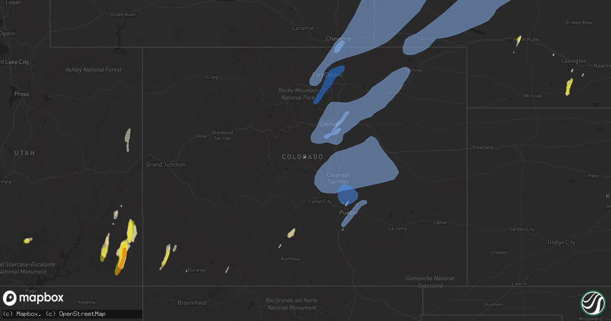
Hail Map in Colorado on June 6, 2020
Get this storm
June 6 map
$229
one time, instant access
Download today. No call, no setup
Keep the $229
Bought the map and want the full workflow? Apply the entire $229 to a subscription within 7 days. None of it is wasted.
Every map, not just this one
This buys you this map. Subscription and you get every map we run, in the markets you choose from a few cities to whole states to nationwide. Plus real-time alerts the moment a storm fires.
Contact data
Name, contact info, occupancy, even credit band for addresses in the footprint. You go from where it hit to who to call.
Become the source they trust
Unlimited branding weather history reports on demand. You already have the documented answer ready for the property owner, and you are the one who showed up with it.
Property data and RoofTrace estimates
Pull up any address you have got, its value and the exact code rules for that jurisdiction, straight from One Click Code. Then RoofTrace estimates the squares, pitch, and roof value, priced the way you price.
Storm reports in Colorado
Colorado
| Date | Description |
|---|---|
| 06/06/20206:55 PM CDT | Asos station kako akron. |
| 06/06/20206:46 PM CDT | Mesonet station dw6400 castle rock. |
| 06/06/20206:33 PM CDT | Asos station klic limon. |
| 06/06/20206:32 PM CDT | Mesonet station co039 076w067 wiggins bijou creek. |
| 06/06/20206:26 PM CDT | A local report indicates 59 MPH wind near LIMON |
| 06/06/20206:20 PM CDT | Mesonet station ew7966 elizabeth. |
| 06/06/20206:18 PM CDT | Mesonet station cw5040 briggsdale. |
| 06/06/20206:15 PM CDT | Awos station kfmm fort morgan. |
| 06/06/20206:14 PM CDT | A local report indicates 63 MPH wind near 8 WNW CROOK |
| 06/06/20206:13 PM CDT | A local report indicates 62 MPH wind near 5 NE BLENDE |
| 06/06/20206:08 PM CDT | Roof and sides blown off a barn. |
| 06/06/20206:01 PM CDT | Mesonet station ew7240 ramaha. |
| 06/06/20205:59 PM CDT | Trees uprooted or snapped; roof blown off. |
| 06/06/20205:52 PM CDT | Mesonet station co073 surrey ridge. |
| 06/06/20205:52 PM CDT | Mesonet station co072 070w304 bennett. |
| 06/06/20205:45 PM CDT | Delayed report: roof peeled off a trailer home near the epco fairgrounds. Time estimated per doppler radar signatures. Doppler radar estimates 70-75 mph winds. |
| 06/06/20205:42 PM CDT | Mesonet station co039 076w067 wiggins bijou creek. |
| 06/06/20205:42 PM CDT | Mesonet station co072 070w304 bennett. |
| 06/06/20205:42 PM CDT | A local report indicates 72 MPH wind near 2 E CASTLE ROCK |
| 06/06/20205:42 PM CDT | Asos station kcos colorado springs airport. |
| 06/06/20205:40 PM CDT | 3 inch diamter branches down. |
| 06/06/20205:38 PM CDT | Delayed report: large barn and tack house knocked over intersection of hwy 94 and antelope drive. Doppler estimated winds of 60-65 mph. |
| 06/06/20205:36 PM CDT | A local report indicates 62 MPH wind near FORT MORGAN |
| 06/06/20205:35 PM CDT | Awos station k1ow oscar madis. |
| 06/06/20205:34 PM CDT | 1-inch tree limbs broken; shingles blown off. |
| 06/06/20205:34 PM CDT | . |
| 06/06/20205:34 PM CDT | A local report indicates 78 MPH wind near 10 ESE ROCKPORT |
| 06/06/20205:30 PM CDT | Awos station kmnh monument elbert. |
| 06/06/20205:30 PM CDT | A local report indicates 77 MPH wind near 6 NE GREENLAND |
| 06/06/20205:26 PM CDT | A local report indicates 61 MPH wind near 1 SE MONUMENT |
| 06/06/20205:24 PM CDT | A local report indicates 58 MPH wind near 3 ENE MANITOU SPRINGS |
| 06/06/20205:22 PM CDT | Mesonet station co038 076e037 keenesburg. |
| 06/06/20205:21 PM CDT | Mesonet station dw9298 keenesburg. |
| 06/06/20205:19 PM CDT | A local report indicates 64 MPH wind near GALETON |
| 06/06/20205:18 PM CDT | A local report indicates 69 MPH wind near 3 SSW AIR FORCE ACADEMY |
| 06/06/20205:18 PM CDT | A local report indicates 60 MPH wind near 2 NNW AIR FORCE ACADEMY |
| 06/06/20205:15 PM CDT | 1-inch tree limbs broken; shingles blown off. |
| 06/06/20205:12 PM CDT | Trees uprooted or snapped; roof blown off. |
| 06/06/20205:09 PM CDT | A local report indicates 72 MPH wind near 5 ESE HUDSON |
| 06/06/20205:06 PM CDT | Tree damage in town. |
| 06/06/20205:06 PM CDT | Trees uprooted or snapped; roof blown off. |
| 06/06/20205:04 PM CDT | Shallow rooted trees pushed over. Numerous power poles down. |
| 06/06/20205:04 PM CDT | Mesonet station ew9243 commerce city. |
| 06/06/20205:02 PM CDT | 1-inch tree limbs broken; shingles blown off. |
| 06/06/20205:02 PM CDT | Mesonet station co171 nunn. |
| 06/06/20205:01 PM CDT | Asos station kden denver. |
| 06/06/20205:01 PM CDT | Mesonet station fw3105 parker. |
| 06/06/20205:00 PM CDT | Mesonet station co010 025s229 sh7. |
| 06/06/20205:00 PM CDT | Large tree uprooted on downing near alameda. |
| 06/06/20205:00 PM CDT | Awos station kbkf buckley angb den. |
| 06/06/20205:00 PM CDT | 3 inch branches and fences downed. |
| 06/06/20204:59 PM CDT | A local report indicates 69 MPH wind near CROOK |
| 06/06/20204:58 PM CDT | Tree damage... Too. 4-6 inch diameter limbs broken. |
| 06/06/20204:57 PM CDT | Green houses and gazebo overturned. |
| 06/06/20204:57 PM CDT | Mesonet station ctpc2 carpenter peak. |
| 06/06/20204:57 PM CDT | Trees uprooted or snapped; roof blown off. |
| 06/06/20204:56 PM CDT | Mesonet station aenc2 arsenal. |
| 06/06/20204:55 PM CDT | Mesonet station up727 2.7 sw brighton |
| 06/06/20204:55 PM CDT | 3-inch tree limbs broken; power poles broken. |
| 06/06/20204:55 PM CDT | Asos station kapa denver arapahoe. |
| 06/06/20204:55 PM CDT | Corrects time from 4 s buckley afb. Trees uprooted or snapped; roof blown off. |
| 06/06/20204:54 PM CDT | Mesonet station polc2 polhemus. |
| 06/06/20204:54 PM CDT | Awos station kbkf buckley angb den. |
| 06/06/20204:52 PM CDT | Mesonet station co035 076e125 sterling. |
| 06/06/20204:51 PM CDT | 3-inch tree limbs broken; power poles broken. |
| 06/06/20204:51 PM CDT | 136th and zuni. |
| 06/06/20204:50 PM CDT | 6 to 10 inch tree branches down. Time estimated from radar. |
| 06/06/20204:50 PM CDT | Asos station kapa denver arapahoe. |
| 06/06/20204:50 PM CDT | Mesonet station co003 070w276 colo. Blvd. |
| 06/06/20204:49 PM CDT | Mesonet station co178 0.1 mi s of 84th ave. |
| 06/06/20204:49 PM CDT | Mesonet station co149 orchard. |
| 06/06/20204:49 PM CDT | Mesonet station co161 0.2 mi n of i-225. |
| 06/06/20204:49 PM CDT | Mesonet station co156 0.7 mi s of northwest pkwy. |
| 06/06/20204:46 PM CDT | 1-inch tree limbs broken; shingles blown off. |
| 06/06/20204:44 PM CDT | Mesonet station co007 470w014 wadsworth. |
| 06/06/20204:44 PM CDT | 1-inch tree limbs broken; shingles blown off. |
| 06/06/20204:43 PM CDT | 1-inch tree limbs broken; shingles blown off. |
| 06/06/20204:42 PM CDT | 1-inch tree limbs broken; shingles blown off. |
| 06/06/20204:42 PM CDT | 1-inch tree limbs broken; shingles blown off. |
| 06/06/20204:41 PM CDT | Awos station kfnl ft collins lovel. |
| 06/06/20204:41 PM CDT | Mesonet station cw5285 littleton. |
| 06/06/20204:40 PM CDT | Tree down. Time estimated from radar. |
| 06/06/20204:40 PM CDT | Numerous 1 inch diameter tree limbs broken. |
| 06/06/20204:40 PM CDT | A local report indicates 65 MPH wind near LAKEWOOD |
| 06/06/20204:39 PM CDT | Mesonet station cw8926 lakewood. |
| 06/06/20204:39 PM CDT | Mesonet station co008 470e000 rooney rd. |
| 06/06/20204:39 PM CDT | 1-inch tree limbs broken; shingles blown off. |
| 06/06/20204:35 PM CDT | May have been a brief gustnado. |
| 06/06/20204:30 PM CDT | Numerous trees down... Broken branches across canon city. |
| 06/06/20204:26 PM CDT | Asos station kako akron. |
| 06/06/20204:25 PM CDT | Corrects previous non-tstm wnd gst report from 1 ne crisman. Mesonet station ew4338 boulder. |
| 06/06/20204:15 PM CDT | A local report indicates 90 MPH wind near 2 E COPPER MOUNTAIN |
| 06/06/20204:10 PM CDT | Tree down blocking lions gate drive. |
| 06/06/20204:10 PM CDT | Trees down blocking cars at devils thumb trailhead. |
| 06/06/20204:10 PM CDT | Trees down near idlewild. |
| 06/06/20204:02 PM CDT | Mesonet station co110 285s195 jefferson. |
| 06/06/20204:00 PM CDT | Top of winter park ski area. |
| 06/06/20204:00 PM CDT | A local report indicates 66 MPH wind near 2 SSE WINTER PARK |
| 06/06/20203:55 PM CDT | Trees down... Partially blocking highway 40. |
| 06/06/20203:55 PM CDT | A local report indicates 1.00 inch wind near 4 E BLUE MOUNTAIN |
| 06/06/20203:39 PM CDT | Mesonet station co159 2.9 mi w of ejmt - the box. |
| 06/06/20203:39 PM CDT | Mesonet station co158 2.4 mi e of silverthorne. |
| 06/06/20203:34 PM CDT | A local report indicates 71 MPH wind near 8 WNW LAST CHANCE |
| 06/06/20203:14 PM CDT | A local report indicates 85 MPH wind near CEDAR POINT |
| 06/06/20203:12 PM CDT | Awos station k0co berthoud pass. |
| 06/06/20203:09 PM CDT | Mesonet station co154 0.6 mi e of co-91 copper mtn. |
| 06/06/20203:09 PM CDT | Tree knocked over by strong winds blocking traffic in both directions on emma road near mile marker 3. |
| 06/06/20202:57 PM CDT | Mesonet station dhoc2 dead horse... Buford 14ene. |
| 06/06/20202:54 PM CDT | Awos station kccu red cliff pass. |
| 06/06/20202:54 PM CDT | A local report indicates 79 MPH wind near 3 ESE COPPER MOUNTAIN |
| 06/06/20202:49 PM CDT | Report from mping: trees uprooted or snapped; roof blown off. |
| 06/06/20202:46 PM CDT | Mesonet station gdrc2 great divide 2sw. |
| 06/06/20202:28 PM CDT | Mesonet station tt290 rbfmz portable1. |
| 06/06/20202:11 PM CDT | Corrects previous non-tstm wnd gst report from 2 s wolf creek pass. Awos station kcpw wolf creek pass. |
| 06/06/20202:02 PM CDT | Asos station keeo meeker airport. |
| 06/06/20201:48 PM CDT | Asos station kril garfield county rgnl ap. |
| 06/06/20201:45 PM CDT | . |
| 06/06/20201:42 PM CDT | Mesonet station co073 surrey ridge. |
| 06/06/20201:18 PM CDT | Mesonet station drac2 dragon road. |
| 06/06/20201:15 PM CDT | Small and heavy rain accompanied wind. |
| 06/06/20201:15 PM CDT | Received small hail. |
| 06/06/202012:59 PM CDT | Social media reports of several very large trees being broken off / uprooted causing damage to cabins and vehicles; time estimated from radar imagery. |
| 06/06/202012:53 PM CDT | . |
| 06/06/202011:50 AM CDT | A local report indicates 1.00 inch wind near DOLORES 2.5 WNW |
| 06/06/20207:59 AM CDT | At 1258 PM MDT, severe thunderstorms were located along a line extending from 14 miles northwest of Meeker to 21 miles northwest of New Castle to 7 miles southeast of Silt, moving northeast at 75 mph. HAZARD...70 mph wind gusts. SOURCE...Radar indicated. IMPACT...Expect considerable tree damage. Damage is likely to mobile homes, roofs, and outbuildings. Locations impacted include... Glenwood Springs, Craig, Rifle, New Castle, Silt, Meeker, Lay, Loyd, Juniper Springs, Buford, Great Divide, Axial, Maybell and Hamilton.This includes the following highways... Interstate 70 in Colorado between mile markers 90 and 118. U.S. Highway 40 in Colorado between mile markers 58 and 94. Colorado 13 between mile markers 1 and 8, and between mile markers24 and 93. Colorado 64 between mile markers 60 and 73. Colorado 82 near mile marker 1. Colorado 318 near mile marker 60. |
| 06/06/20207:28 AM CDT | At 1228 PM MDT, severe thunderstorms were located along a line extending from 19 miles northwest of Parachute to 6 miles south of Collbran, moving northeast at 80 mph. HAZARD...70 mph wind gusts. SOURCE...Radar indicated. IMPACT...Expect considerable tree damage. Damage is likely to mobile homes, roofs, and outbuildings. Locations impacted include... Rifle, New Castle, Silt, Meeker, Parachute, Collbran, De Beque, Rio Blanco, Battlement Mesa, Plateau City and Molina.This includes the following highways... Interstate 70 in Colorado between mile markers 62 and 104. Colorado 13 between mile markers 1 and 56. Colorado 64 between mile markers 71 and 73. Colorado 65 near mile marker 34. |
| 06/06/20206:59 AM CDT | At 1159 AM MDT, severe thunderstorms were located along a line extending from 9 miles northeast of Fruita to 6 miles northwest of Delta to 13 miles west of Montrose, moving northeast at 70 mph. HAZARD...70 mph wind gusts and penny size hail. SOURCE...Trained weather spotters. IMPACT...Expect considerable tree damage. Damage is likely to mobile homes, roofs, and outbuildings. Locations impacted include... Grand Junction, Montrose, Fruita, Delta, Orchard City, Palisade, Cedaredge, Olathe, Parachute, Hotchkiss, Collbran, De Beque, Crawford, Mesa, Battlement Mesa, Cameo, Molina, Austin, Grand Mesa and Orchard Mesa.This includes the following highways... Interstate 70 in Colorado between mile markers 20 and 89. U.S. Highway 50 in Colorado between mile markers 32 and 91. Colorado 65 between mile markers 1 and 61. Colorado 90 mile marker 82 and near mile marker 88. Colorado 92 between mile markers 1 and 31. Colorado 133 between mile markers 1 and 7. Colorado 141 between mile markers 147 and 162. |
| 06/06/20206:19 AM CDT | At 1119 AM MDT, severe thunderstorms were located along a line extending from 34 miles east of Sunnyside to 37 miles west of Fruita to 18 miles northeast of Castle Valley, moving north at 65 mph. HAZARD...70 mph wind gusts and penny size hail. SOURCE...Radar indicated. IMPACT...Expect considerable tree damage. Damage is likely to mobile homes, roofs, and outbuildings. Locations impacted include... Cisco.This includes the following highways... Interstate 70 in Colorado between mile markers 1 and 5. Interstate 70 in Utah between mile markers 206 and 231. Utah 128 between mile markers 32 and 43. |
| 06/06/20206:13 AM CDT | At 1112 AM MDT, a severe thunderstorm was located 22 miles west of Rico, or 46 miles northwest of Durango, moving northeast at 45 mph. HAZARD...60 mph wind gusts and quarter size hail. SOURCE...Radar indicated. IMPACT...Hail damage to vehicles is expected. Expect wind damage to roofs, siding, and trees. This severe thunderstorm will remain over mainly rural areas of north central Dolores, central San Miguel and northeastern Montezuma Counties. |
| 06/06/20205:53 AM CDT | At 1052 AM MDT, severe thunderstorms were located along a line extending from 7 miles west of La Sal to 8 miles west of Slick Rock to near Dove Creek, moving north at 60 mph. These are very dangerous storms. HAZARD...90 mph wind gusts and golf ball size hail. SOURCE...Law enforcement. IMPACT...You are in a life-threatening situation. Flying debris may be deadly to those caught without shelter. Mobile homes will be heavily damaged or destroyed. Homes and businesses will have substantial roof and window damage. Expect extensive tree damage and power outages. Locations impacted include... La Sal, Nucla, Naturita, Slick Rock, Spanish Valley, Egnar, Paradox, Vancorum, La Sal Junction, Bedrock, Gateway, Summit Point and Uravan.This includes the following highways... U.S. Highway 191 in Utah between mile markers 92 and 107. Colorado 90 between mile markers 1 and 33. Colorado 141 between mile markers 3 and 115. Colorado 145 between mile markers 112 and 116. |
| 06/06/20205:44 AM CDT | At 1043 AM MDT, a severe thunderstorm was located 7 miles west of Dolores, or 43 miles west of Durango, moving north at 55 mph. HAZARD...60 mph wind gusts and quarter size hail. SOURCE...Radar indicated. IMPACT...Hail damage to vehicles is expected. Expect wind damage to roofs, siding, and trees. Locations impacted include... Cortez, Dolores, Lebanon, Arriola, Yellow Jacket and Lewis. This includes the following highways... U.S. Highway 491 in Colorado between mile markers 27 and 43. U.S. Highway 160 in Colorado between mile markers 38 and 42. Colorado 145 between mile markers 1 and 12. |
| 06/06/20201:43 AM CDT | At 642 PM MDT, severe thunderstorms were located along a line extending from 7 miles west of Ellsworth to 9 miles north of Oshkosh to near Julesburg, moving east at 55 mph. HAZARD...70 mph wind gusts. SOURCE...Radar indicated. IMPACT...Expect considerable tree damage. Damage is likely to mobile homes, roofs, and outbuildings. Locations impacted include... Ogallala, Oshkosh, Big Springs, Brule, Lewellen, Kingsley Dam, Ashby, Barton, Lemoyne, Crescent Lake National Wildlife Refuge, Dogtown Flats, Swede Lake, Deer Lake, Britton Lake, Megeath, Mumper, Bourquim Hill, Herman Lake, Adams Flats and Sugar Loaf Hill.This includes the following highways... Highway 2 between mile markers 133 and 143. Highway 61 between mile markers 81 and 122, and between mile markers145 and 146. Highway 92 between mile markers 115 and 138. Interstate 80 in Nebraska between mile markers 92 and 131. |
| 06/06/20201:08 AM CDT | At 605 PM MDT, severe thunderstorms were located along a line extending from 10 miles southwest of Thurman to 13 miles southeast of Truckton, or along a line extending from 21 miles northwest of Flagler to 40 miles northeast of Pueblo, moving northeast at 55 mph. HAZARD...70 mph wind gusts. SOURCE...Radar indicated. IMPACT...Expect considerable tree damage. Damage is likely to mobile homes, roofs, and outbuildings. Locations impacted include... Hugo, Arriba, Genoa, Boyero, Karval, Punkin Center, Kutch, Wild Horse Point and Forder. |
| 06/06/202012:58 AM CDT | At 557 PM MDT, severe thunderstorms were located along a line extending from 3 miles south of Peetz to 8 miles south of Lindon, or along a line extending from 17 miles southwest of Sidney to 28 miles northeast of Limon, moving northeast at 55 mph. HAZARD...70 mph wind gusts. SOURCE...Radar indicated. IMPACT...Expect considerable tree damage. Damage is likely to mobile homes, roofs, and outbuildings. Locations impacted include... Sterling, Akron, Otis, Fleming, Merino, Iliff, Peetz, Crook, Arickaree School, Prewitt Reservoir, Padroni, Atwood, Burdett, Lindon, Midway, Lone Star, Thurman, Cope, Anton and St Petersburg. |
| 06/06/202012:27 AM CDT | At 526 PM MDT, severe thunderstorms were located along a line extending from 6 miles south of Byers to 3 miles north of Simla, or along a line extending from 37 miles east of Denver to 20 miles west of Limon, moving northeast at 60 mph. HAZARD...75 mph wind gusts. SOURCE...Radar indicated. IMPACT...Expect considerable tree damage. Damage is likely to mobile homes, roofs, and outbuildings. Locations impacted include... Limon, Hugo, Arriba, Genoa, Boyero, Matheson, Agate and Kutch. |
| 06/06/202012:18 AM CDT | At 517 PM MDT, severe thunderstorms were located along a line extending from 9 miles south of Kimball Airport to 5 miles northeast of Antelope Springs to near Leader, or along a line extending from 12 miles south of Kimball to 18 miles northeast of Fort Morgan to 48 miles north of Limon, moving northeast at 60 mph. HAZARD...70 mph wind gusts. SOURCE...Radar indicated. IMPACT...Expect considerable tree damage. Damage is likely to mobile homes, roofs, and outbuildings. Locations impacted include... Sterling, Fort Morgan, Akron, Brush, Log Lane Village, Deer Trail, Merino, Iliff, Hillrose, Peetz, Prewitt Reservoir, Shamrock, Leader, Padroni, Atwood, Twelve-Mile Corner, Stoneham, Byers, Westplains and Cottonwood Valley. |
| 06/06/202012:11 AM CDT | At 510 PM MDT, a severe thunderstorm was located 13 miles south of Salt Creek, or 15 miles south of Pueblo, moving northeast at 65 mph. This is a very dangerous storm. HAZARD...80 mph wind gusts and quarter size hail. SOURCE...Radar indicated. IMPACT...Flying debris will be dangerous to those caught without shelter. Mobile homes will be heavily damaged. Expect considerable damage to roofs, windows, and vehicles. Extensive tree damage and power outages are likely. Locations impacted include... Pueblo, Fowler, Calhan, Manzanola, Olney Springs, Boone, Crowley, Ramah, Hanover, Truckton, Yoder, Salt Creek, Ellicott, Pueblo Depot, Pinon, Blende, Avondale, Rush, Pueblo Reservoir and Pueblo West. |
| 06/05/202011:56 PM CDT | At 455 PM MDT, severe thunderstorms were located along a line extending from near Meriden Rest Area to near Grover, moving northeast at 60 mph. HAZARD...70 mph wind gusts. SOURCE...Radar indicated. IMPACT...Expect considerable tree damage. Damage is likely to mobile homes, roofs, and outbuildings. Locations impacted include... Kimball, Pine Bluffs, Morrill, La Grange, Lyman, Burns, Dix, Albin, Oliver Campground, Hillsdale, Stegall, Panorama Point, Hawk Springs, Hawk Springs Campground, Oliver Reservoir, Hubbard Hill, Kimball Airport, Hawk Springs Recreation Area, Harrisburg and Meriden Rest Area.This includes the following highways... Interstate 80 in Wyoming between mile markers 378 and 402. Interstate 80 in Nebraska between mile markers 1 and 35. |
| 06/05/202011:50 PM CDT | At 450 PM MDT, a severe thunderstorm was located 16 miles east of Greenhorn Mountain, or 21 miles south of Pueblo, moving northeast at 55 mph. HAZARD...60 mph wind gusts and nickel size hail. SOURCE...Radar indicated. IMPACT...Expect damage to roofs, siding, and trees. Locations impacted include... Colorado City. |
| 06/05/202011:50 PM CDT | At 449 PM MDT, severe thunderstorms were located along a line extending from 10 miles northeast of Ponderosa Park to 8 miles northwest of Calhan, or along a line extending from 26 miles southeast of Denver to 28 miles northeast of Colorado Springs, moving northeast at 60 mph. These are very dangerous storms. HAZARD...80 mph wind gusts. SOURCE...Radar indicated. IMPACT...Flying debris will be dangerous to those caught without shelter. Mobile homes will be heavily damaged. Expect considerable damage to roofs, windows, and vehicles. Extensive tree damage and power outages are likely. Locations impacted include... Limon, Elbert, Hugo, Kiowa, Simla, Arriba, Genoa, Ramah, Matheson and Agate. |
| 06/05/202011:43 PM CDT | At 443 PM MDT, severe thunderstorms were located along a line extending from near Kiowa to 6 miles north of Ellicott to near Pinon, moving northeast at 60 mph. These are very dangerous storms. HAZARD...80 mph wind gusts and quarter size hail. SOURCE...Radar indicated. IMPACT...Flying debris will be dangerous to those caught without shelter. Mobile homes will be heavily damaged. Expect considerable damage to roofs, windows, and vehicles. Extensive tree damage and power outages are likely. Locations impacted include... Southeastern Colorado Springs, Pueblo, Fountain, Calhan, Boone, Ramah, Hanover, Truckton, Yoder, Peyton, Pinon, Security, Falcon, Security-Widefield, Blende, Avondale, Rush, Pueblo Reservoir, Salt Creek and Ellicott. |
| 06/05/202011:36 PM CDT | At 433 PM MDT, severe thunderstorms were located along a line extending from 4 miles northwest of Briggsdale to near Bennett, or along a line extending from 25 miles northeast of Greeley to 26 miles east of Denver, moving northeast at 60 mph. HAZARD...80 mph wind gusts. SOURCE...Radar indicated. IMPACT...Expect considerable tree damage. Damage is likely to mobile homes, roofs, and outbuildings. Locations impacted include... Southeastern Greeley, Fort Morgan, eastern Aurora, eastern Denver International Airport, Hudson, Bennett, Kersey, Keenesburg, Wiggins, Log Lane Village, Deer Trail, Grover, Purcell, Galeton, Shamrock, Weldona, Leader, Twelve-Mile Corner, Strasburg and Orchard. |
| 06/05/202011:34 PM CDT | At 434 PM MDT, a severe thunderstorm was located 7 miles north of Pueblo West, or 15 miles northwest of Pueblo, moving northeast at 50 mph. HAZARD...60 mph wind gusts. SOURCE...Radar indicated. IMPACT...Expect damage to roofs, siding, and trees. Locations impacted include... Pueblo, Fountain, Pueblo Reservoir, Salt Creek, Blende, Pueblo West, Pinon and Hanover. |
| 06/05/202011:23 PM CDT | At 422 PM MDT, a severe thunderstorm was located 7 miles east of Ranchettes, or 8 miles northeast of Cheyenne, moving northeast at 60 mph. HAZARD...60 mph wind gusts. SOURCE...Radar indicated. IMPACT...Expect damage to roofs, siding, and trees. Locations impacted include... Pine Bluffs, La Grange, Albin, Hawk Springs Campground, Hawk Springs Recreation Area, Meriden Rest Area, Gun Barrel and Carpenter.This includes Interstate 80 in Wyoming between mile markers 388 and402. |
| 06/05/202011:19 PM CDT | At 419 PM MDT, a severe thunderstorm was located near Penrose, or 23 miles northwest of Pueblo, moving northeast at 50 mph. HAZARD...60 mph wind gusts and quarter size hail. SOURCE...Radar indicated. IMPACT...Hail damage to vehicles is expected. Expect wind damage to roofs, siding, and trees. Locations impacted include... Southern Colorado Springs, Fountain, Penrose, Fort Carson, Security, Stratmoor, Security-Widefield and Canon City. |
| 06/05/202011:11 PM CDT | At 411 PM MDT, a severe thunderstorm was located near Pinon, or 13 miles north of Pueblo, moving northeast at 65 mph. HAZARD...70 mph wind gusts and quarter size hail. SOURCE...Radar indicated. IMPACT...Hail damage to vehicles is expected. Expect considerable tree damage. Wind damage is also likely to mobile homes, roofs, and outbuildings. Locations impacted include... Southeastern Colorado Springs, northern Pueblo, Fountain, Hanover, Yoder, Ellicott, Peyton, Schriever AFB, Pinon, Security, Falcon, Security-Widefield, Peterson AFB, Cimarron Hills, Pueblo West and Fort Carson. |
| 06/05/202011:01 PM CDT | At 401 PM MDT, a severe thunderstorm was located near Woodland Park, or 14 miles northwest of Colorado Springs, moving east at 40 mph. HAZARD...70 mph wind gusts and penny size hail. SOURCE...Radar indicated. IMPACT...Expect considerable tree damage. Damage is likely to mobile homes, roofs, and outbuildings. Locations impacted include... Colorado Springs, Woodland Park, Monument, Air Force Academy, Manitou Springs, Palmer Lake, Calhan, Green Mountain Falls, Ramah, Yoder, Peyton, Falcon, Stratmoor, Chipita Park, Gleneagle, Cimarron Hills, Cascade, Rush, Pikes Peak and Black Forest. |
| 06/05/202010:56 PM CDT | At 355 PM MDT, severe thunderstorms were located along a line extending from 6 miles south of Carr to 3 miles east of Dacono to Aurora to 5 miles east of Greenland, or along a line extending from 21 miles northeast of Fort Collins to 24 miles south of Greeley to 10 miles east of Denver to 22 miles north of Colorado Springs, moving northeast at 60 mph. These are very dangerous storms. HAZARD...80 mph wind gusts. SOURCE...Radar indicated. IMPACT...Flying debris will be dangerous to those caught without shelter. Mobile homes will be heavily damaged. Expect considerable damage to roofs, windows, and vehicles. Extensive tree damage and power outages are likely. Locations impacted include... Denver, Fort Collins, Greeley, Aurora, eastern Lakewood, Thornton, southeastern Arvada, Westminster, Centennial, eastern Longmont, Loveland, Broomfield, Highlands Ranch, Castle Rock, Commerce City, Parker, Littleton, Northglenn, Brighton and Englewood. |
| 06/05/202010:43 PM CDT | At 343 PM MDT, a severe thunderstorm was located 14 miles west of Junkins Burn Scar, moving northeast at 50 mph. HAZARD...60 mph wind gusts and quarter size hail. SOURCE...Radar indicated. IMPACT...Hail damage to vehicles is expected. Expect wind damage to roofs, siding, and trees. Locations impacted include... Junkins Burn Scar, Florence, Canon City, Silver Cliff, Westcliffe, Wetmore and Rosita. |
| 06/05/202010:39 PM CDT | At 339 PM MDT, a severe thunderstorm was located near Pinon, or 9 miles north of Pueblo, moving north at 70 mph. HAZARD...70 mph wind gusts and quarter size hail. SOURCE...Radar indicated. IMPACT...Hail damage to vehicles is expected. Expect considerable tree damage. Wind damage is also likely to mobile homes, roofs, and outbuildings. Locations impacted include... Pueblo, Hanover, Truckton, Yoder, Ellicott, Peyton, Schriever AFB, Pueblo West, Pinon and Rush. |
| 06/05/202010:29 PM CDT | At 329 PM MDT, a severe thunderstorm was located 7 miles northeast of Crestone Peak, or 21 miles southeast of Hayden Pass Burn Scar, moving northeast at 55 mph. HAZARD...60 mph wind gusts and quarter size hail. SOURCE...Radar indicated. IMPACT...Hail damage to vehicles is expected. Expect wind damage to roofs, siding, and trees. Locations impacted include... Junkins Burn Scar, Crestone Peak, Great Sand Dunes, Silver Cliff, Westcliffe and Rosita. |
| 06/05/202010:15 PM CDT | At 315 PM MDT, a severe thunderstorm was located 7 miles north of Penrose, or 22 miles south of Colorado Springs, moving north at 65 mph. HAZARD...60 mph wind gusts and quarter size hail. SOURCE...Radar indicated. IMPACT...Hail damage to vehicles is expected. Expect wind damage to roofs, siding, and trees. Locations impacted include... Colorado Springs, Fountain, Manitou Springs, Stratmoor, Penrose, Fort Carson, Security, Peterson AFB, Security-Widefield, Cimarron Hills and Cascade. |
| 06/05/202010:03 PM CDT | At 303 PM MDT, severe thunderstorms were located along a line extending from 3 miles north of Drake to near Aspen Springs to 8 miles west of Elevenmile Canyon Reservoir, or along a line extending from 15 miles west of Fort Collins to 28 miles west of Denver to 39 miles north of Hayden Pass Burn Scar, moving northeast at 65 mph. These are very dangerous storms. HAZARD...80 mph wind gusts. SOURCE...Radar indicated. IMPACT...Flying debris will be dangerous to those caught without shelter. Mobile homes will be heavily damaged. Expect considerable damage to roofs, windows, and vehicles. Extensive tree damage and power outages are likely. Locations impacted include... Denver, Fort Collins, Greeley, Aurora, Lakewood, Thornton, Arvada, Westminster, Centennial, Boulder, Longmont, Loveland, Broomfield, Highlands Ranch, Castle Rock, Commerce City, Parker, Littleton, Northglenn and Brighton. |
| 06/05/20209:59 PM CDT | At 259 PM MDT, a severe thunderstorm was located 8 miles south of Moffat, or 28 miles north of Alamosa, moving northeast at 55 mph. HAZARD...60 mph wind gusts and quarter size hail. SOURCE...Radar indicated. IMPACT...Hail damage to vehicles is expected. Expect wind damage to roofs, siding, and trees. Locations impacted include... Crestone, Moffat, Hooper, Crestone Peak and Great Sand Dunes. |
| 06/05/20209:54 PM CDT | At 254 PM MDT, a severe thunderstorm was located 19 miles northeast of Rangely, or 52 miles east of Vernal, moving northeast at 50 mph. HAZARD...60 mph wind gusts and quarter size hail. SOURCE...Radar indicated. IMPACT...Hail damage to vehicles is expected. Expect wind damage to roofs, siding, and trees. Locations impacted include... Elk Springs.This includes the following highways... U.S. Highway 40 in Colorado between mile markers 22 and 53. Colorado 318 between mile markers 47 and 50. |
| 06/05/20209:44 PM CDT | At 244 PM MDT, a severe thunderstorm was located near Hayden Pass Burn Scar, moving northeast at 55 mph. HAZARD...60 mph wind gusts and quarter size hail. SOURCE...Radar indicated. IMPACT...Hail damage to vehicles is expected. Expect wind damage to roofs, siding, and trees. Locations impacted include... Hayden Pass Burn Scar, eastern Decker Burn Scar, Texas Creek, Howard, Coaldale, Waugh Mountain, Swissvale and Cotopaxi. |
| 06/05/20209:40 PM CDT | 2 inch diameter tree branches broken. |
| 06/05/20209:33 PM CDT | At 232 PM MDT, severe thunderstorms were located along a line extending from near Cowdrey to near Berthoud Pass to 10 miles northwest of Guffey, or along a line extending from 51 miles southwest of Laramie to 43 miles west of Denver to 36 miles north of Hayden Pass Burn Scar, moving northeast at 65 mph. These are very dangerous storms. HAZARD...80 mph wind gusts. SOURCE...Radar indicated. IMPACT...Flying debris will be dangerous to those caught without shelter. Mobile homes will be heavily damaged. Expect considerable damage to roofs, windows, and vehicles. Extensive tree damage and power outages are likely. Locations impacted include... Jefferson, Evergreen, Estes Park, Breckenridge, Silverthorne, Frisco, Lake George, Granby, Trail Ridge, Idaho Springs, Nederland, Fraser, Georgetown, Bear Lake, Winter Park, Dillon, Blue River, Fairplay, Central City and Hot Sulphur Springs. |
| 06/05/20209:29 PM CDT | At 228 PM MDT, severe thunderstorms were located along a line extending from 6 miles southeast of Wamsutter to 6 miles southwest of Battle Creek Campground, moving north at 65 mph. This line of storms has a history of producing strong wind gusts behind the leading line. HAZARD...60 mph wind gusts. SOURCE...Radar indicated. IMPACT...Expect damage to roofs, siding, and trees. Locations impacted include... Baggs, Dixon, Battle Creek Campground, Savery, Dad and Little Sandstone Creek Campground. |
| 06/05/20209:28 PM CDT | At 228 PM MDT, a severe thunderstorm was located 7 miles southeast of Stonewall, or 25 miles west of Trinidad, moving northeast at 60 mph. HAZARD...70 mph wind gusts. SOURCE...Radar indicated. IMPACT...Expect considerable tree damage. Damage is likely to mobile homes, roofs, and outbuildings. Locations impacted include... Walsenburg, Aguilar, Gulnare, Boncarbo, Stonewall, Segundo and Weston. |
| 06/05/20209:25 PM CDT | At 225 PM MDT, a severe thunderstorm was located near Monte Vista, or 18 miles west of Alamosa, moving northeast at 60 mph. HAZARD...70 mph wind gusts and quarter size hail. SOURCE...Radar indicated. IMPACT...Hail damage to vehicles is expected. Expect considerable tree damage. Wind damage is also likely to mobile homes, roofs, and outbuildings. Locations impacted include... Monte Vista, Center, Hooper, Mosca and Great Sand Dunes. |
| 06/05/20209:15 PM CDT | At 215 PM MDT, a severe thunderstorm was located 7 miles west of Hugo, or 8 miles southeast of Limon, moving northeast at 65 mph. This is a very dangerous storm. HAZARD...80 mph wind gusts. SOURCE...Radar indicated. IMPACT...Flying debris will be dangerous to those caught without shelter. Mobile homes will be heavily damaged. Expect considerable damage to roofs, windows, and vehicles. Extensive tree damage and power outages are likely. Locations impacted include... Limon, Hugo, Arriba, Genoa, Thurman, Arickaree School, Cope, Anton, Elba, Woodlin School, Lindon and Last Chance. |
| 06/05/20208:55 PM CDT | At 154 PM MDT, severe thunderstorms were located along a line extending from 8 miles south of Savery to near Hayden to 7 miles south of Yampa, moving northeast at 65 mph. HAZARD...70 mph wind gusts. SOURCE...Public reported damage to structures. IMPACT...Expect considerable tree damage. Damage is likely to mobile homes, roofs, and outbuildings. Locations impacted include... Steamboat Springs, Hayden, Oak Creek, Yampa, Mt Zirkel, Clark, Milner, Tow Creek, Toponas, Hahns Peak, Slater and Phippsburg.This includes the following highways... U.S. Highway 40 in Colorado between mile markers 111 and 152. Colorado 13 near mile marker 127. Colorado 131 between mile markers 23 and 68. Colorado 134 between mile markers 1 and 11. |
| 06/05/20208:51 PM CDT | At 150 PM MDT, severe thunderstorms were located along a line extending from near Cherokee Park to 3 miles north of Highland Park, or along a line extending from 26 miles south of Laramie to 34 miles west of Denver, moving east at 50 mph. HAZARD...70 mph wind gusts. SOURCE...Radar indicated. IMPACT...Expect considerable tree damage. Damage is likely to mobile homes, roofs, and outbuildings. Locations impacted include... Breckenridge, Silverthorne, Frisco, Granby, Trail Ridge, Fraser, Georgetown, Winter Park, Dillon, Blue River, Hot Sulphur Springs, Grand Lake, Empire, Silver Plume, Berthoud Pass, Loveland Pass, Berthoud Falls, Bakerville, Vail Pass and Cameron Pass. |
| 06/05/20208:46 PM CDT | At 146 PM MDT, a severe thunderstorm was located 15 miles southeast of Wolf Creek Pass, or 29 miles north of Chama, moving northeast at 60 mph. HAZARD...70 mph wind gusts and nickel size hail. SOURCE...Radar indicated. IMPACT...Expect considerable tree damage. Damage is likely to mobile homes, roofs, and outbuildings. Locations impacted include... Platoro. |
| 06/05/20208:45 PM CDT | Mesonet station tt562 north sterling. |
| 06/05/20208:30 PM CDT | At 129 PM MDT, a severe thunderstorm was located 14 miles northeast of Wagon Wheel Gap, or 44 miles south of Gunnison, moving northeast at 45 mph. HAZARD...70 mph wind gusts and nickel size hail. SOURCE...Radar indicated. IMPACT...Expect considerable tree damage. Damage is likely to mobile homes, roofs, and outbuildings. Locations impacted include... South Fork, North Pass, Wagon Wheel Gap and Wolf Creek Pass. |
| 06/05/20208:28 PM CDT | At 126 PM MDT, severe thunderstorms were located along a line extending from 13 miles northwest of Craig to 18 miles southwest of Hayden to 22 miles north of Glenwood Springs, moving northeast at 65 mph. HAZARD...70 mph wind gusts. SOURCE...Radar indicated. IMPACT...Expect considerable tree damage. Damage is likely to mobile homes, roofs, and outbuildings. Locations impacted include... Craig, Hayden, Oak Creek, Yampa, Great Divide, Milner, Lay, Tow Creek, Hamilton, Slater, Phippsburg and Fortification.This includes the following highways... U.S. Highway 40 in Colorado between mile markers 72 and 127. Colorado 13 between mile markers 69 and 127. Colorado 131 between mile markers 35 and 63. |
| 06/05/20208:28 PM CDT | At 127 PM MDT, severe thunderstorms were located along a line extending from 27 miles south of Adobe Town Rim to 15 miles north of Glenwood Springs, moving northeast at 60 mph. HAZARD...70 mph wind gusts. SOURCE...Radar indicated. IMPACT...Expect considerable tree damage. Damage is likely to mobile homes, roofs, and outbuildings. Locations impacted include... Baggs, Dixon, Battle Lake, Savery, Dad, Jack Creek Campground, Lost Creek Campground, Little Sandstone Creek Campground, Hog Park Campground, Battle Creek Campground, Haskins Creek Campground and Hog Park Reservoir. |
| 06/05/20208:26 PM CDT | . |
| 06/05/20208:04 PM CDT | At 103 PM MDT, a severe thunderstorm was located near Wolf Creek Pass, or 43 miles north of Dulce, moving northeast at 55 mph. This is a very dangerous storm. HAZARD...80 mph wind gusts and penny size hail. SOURCE...Radar indicated. IMPACT...Flying debris will be dangerous to those caught without shelter. Mobile homes will be heavily damaged. Expect considerable damage to roofs, windows, and vehicles. Extensive tree damage and power outages are likely. Locations impacted include... South Fork, Creede, Wagon Wheel Gap and Wolf Creek Pass. |
| 06/05/20207:45 PM CDT | Yuma county em reports power outage near south buffalo and yuma area. |
| 06/05/20207:40 PM CDT | A local report indicates 70 MPH wind near 1 N JULESBURG |
| 06/05/20207:29 PM CDT | A local report indicates 60 MPH wind near 1 E FAIRFIELD |
| 06/05/20207:00 PM CDT | Mesonet station ew7755 akron. |
| 06/05/20207:00 PM CDT | . |
All States Impacted by Hail Map on June 6, 2020
Cities Impacted by Hail Map on June 6, 2020
- Flandreau, SD
- Colman, SD
- Rye, CO
- Faith, SD
- Canterbury, CT
- Windham, CT
- Baltic, CT
- Jewett City, CT
- Atkinson, NE
- Stuart, NE
- Denmark, ME
- Fryeburg, ME
- Left Hand, WV
- Clendenin, WV
- Amma, WV
- Millville, MA
- Uxbridge, MA
- Backus, MN
- Pine River, MN
- Cahone, CO
- Blanding, UT
- Lake Powell, UT
- Armour, SD
- Corsica, SD
- Louisa, KY
- Dolores, CO
- Jordan, MN
- Vernal, UT
- Thompson, UT
- Patriot, OH
- Gallipolis, OH
- Wolford, ND
- Port Haywood, VA
- Susan, VA
- Becker, MN
- Princeton, MN
- Flasher, ND
- Auburn, MA
- Worcester, MA
- North Grafton, MA
- Millbury, MA
- Bowling Green, VA
- Woodford, VA
- Tappahannock, VA
- Newtown, VA
- Fredericksburg, VA
- Walkerton, VA
- Bruington, VA
- Aylett, VA
- Saint Stephens Church, VA
- Milford, VA
- Port Royal, VA
- Ruther Glen, VA
- Dupree, SD
- Bristow, NE
- Oneill, NE
- Spencer, NE
- Harts, WV
- Chapmanville, WV
- Edison, NE
- Elwood, NE
- Arapahoe, NE
- Goodrich, ND
- Cobbs Creek, VA
- Gloucester, VA
- North, VA
- Dutton, VA
- Hartfield, VA
- Marlborough, CT
- Lake George, CO
- Grayson, KY
- Webbville, KY
- Hitchins, KY
- Wall, SD
- Mekinock, ND
- Quinn, SD
- Howes, SD
- Wasta, SD
- Scenic, SD
- Little Falls, MN
- Escalante, UT
- Sauk Rapids, MN
- Cayuga, ND
- Lidgerwood, ND
- Warwick, ND
- New Rockford, ND
- Upton, MA
- Cortez, CO
- Bowlus, MN
- Holdingford, MN
- Hensel, ND
- Cavalier, ND
- Clewiston, FL
- Holden, WV
- Logan, WV
- Dunlow, WV
- Genoa, WV
- Monticello, UT
- Denhoff, ND
- Bemidji, MN
- Looneyville, WV
- Newton, WV
- Plummer, MN
- Minot, ND
- Northwood, ND
- West Brookfield, MA
- North Brookfield, MA
- Warren, MA
- Ireland, WV
- Reeder, ND
- Royalton, MN
- Rice, MN
- Saint Joseph, MN
- Avon, MN
- Glenwood, WV
- Crown City, OH
- Fairfax, SD
- Lynch, NE
- Poland, ME
- Naples, ME
- New Gloucester, ME
- Casco, ME
- Raymond, ME
- Verndale, MN
- Staples, MN
- Hazen, ND
- Hesperus, CO
- Las Vegas, NM
- Tinnie, NM
- Capitan, NM
- Upton, WY
- Mott, ND
- Culloden, WV
- Ranger, WV
- Mud Butte, SD
- Veblen, SD
- Medfield, MA
- Walpole, MA
- Dover, MA
- Griffithsville, WV
- Hamlin, WV
- Yawkey, WV
- Hurricane, WV
- Sod, WV
- Deep River, CT
- Killingworth, CT
- Bertrand, NE
- Spencer, WV
- Melfa, VA
- Wagner, SD
- Lake Andes, SD
- Pueblo, CO
- Hebron, ND
- Rush City, MN
- Grantsburg, WI
- Almont, ND
- Foley, MN
- Mathews, VA
- Cardinal, VA
- Bohannon, VA
- Foster, VA
- Boswell, OK
- Rock Cave, WV
- Lenore, WV
- Breeden, WV
- Wilsondale, WV
- Kermit, WV
- Union Center, SD
- Selden, KS
- Warsaw, VA
- Mcville, ND
- Isle, MN
- Aitkin, MN
- Carson, ND
- Ellamore, WV
- Coalton, WV
- Labelle, FL
- Pagosa Springs, CO
- Voltaire, ND
- Cherry Creek, SD
- Cohagen, MT
- Terry, MT
- Branchland, WV
- Salt Rock, WV
- Barboursville, WV
- Bolton, MA
- Stow, MA
- Sudbury, MA
- Hudson, MA
- Maddock, ND
- Bigfork, MN
- Milton, WV
- Rosebud, MT
- Hathaway, MT
- Bethel, MN
- Stacy, MN
- Isanti, MN
- Oakes, ND
- North Platte, NE
- Garrison, ND
- Ryder, ND
- Berwick, ME
- North Berwick, ME
- Ogunquit, ME
- Wells, ME
- South Berwick, ME
- Holland, MN
- Big Bend, WV
- Grace City, ND
- Meadow, SD
- Jericho, NY
- Elkton, SD
- Circle, MT
- Sartell, MN
- Ocate, NM
- North Franklin, CT
- South Windham, CT
- Alkol, WV
- Danville, WV
- Julian, WV
- Gettysburg, SD
- Geddes, SD
- Motley, MN
- Pine City, MN
- Deer River, MN
- Spring Lake, MN
- Max, MN
- Douglas, ND
- Kinsey, MT
- Wyndmere, ND
- Belle Plaine, MN
- Carver, MN
- Pipestone, MN
- Center, CO
- Moffat, CO
- Balaton, MN
- Ruthton, MN
- Cumberland, RI
- Esmond, ND
- Mcclusky, ND
- Zap, ND
- Valmora, NM
- Watrous, NM
- Emerado, ND
- Bridgton, ME
- Argyle, MN
- Alvarado, MN
- Oslo, MN
- Manvel, ND
- Grand Forks Afb, ND
- Webster Springs, WV
- Cowen, WV
- Shakopee, MN
- Sanbornville, NH
- Shapleigh, ME
- Acton, ME
- Winfred, SD
- Sutton, MA
- Charlton, MA
- Rochdale, MA
- Oxford, MA
- North Oxford, MA
- Tyler, MN
- Gilby, ND
- Minto, ND
- Harrisville, RI
- North Smithfield, RI
- Douglas, MA
- Nisland, SD
- Vale, SD
- Whitewood, SD
- Newell, SD
- Sawyer, OK
- Park Rapids, MN
- Ona, WV
- Alamo, ND
- Slatersville, RI
- Leicester, MA
- Blackstone, MA
- Wrentham, MA
- Franklin, MA
- Brookfield, MA
- Spencer, MA
- Whitinsville, MA
- Bellingham, MA
- Mendon, MA
- East Brookfield, MA
- Woonsocket, RI
- Forestdale, RI
- Rugby, ND
- Madison, SD
- Topping, VA
- Saluda, VA
- Locust Hill, VA
- Hershey, NE
- Brookings, SD
- Nevis, MN
- Sutton, WV
- Prichard, WV
- Menahga, MN
- Atoka, OK
- Snowville, UT
- West Hamlin, WV
- Max, ND
- Harvey, ND
- East Wakefield, NH
- Wolfeboro, NH
- Aurora, ME
- Ellsworth, ME
- Butte, NE
- Mapleton, ND
- Gann Valley, SD
- Hettinger, ND
- Arthur City, TX
- Walker, MN
- Powderly, TX
- Beulah, ND
- Walton, WV
- Hayes, VA
- Sauk Centre, MN
- Osakis, MN
- West Union, MN
- Dingess, WV
- Hackensack, MN
- Forest River, ND
- Deltaville, VA
- Norcross, MN
- Lemmon, SD
- Wentworth, SD
- Rutland, SD
- Mcgregor, ND
- Heathsville, VA
- Kilmarnock, VA
- Lignite, ND
- Portal, ND
- Elbow Lake, MN
- Columbus, ND
- Crosby, ND
- Saint Francis, MN
- Cedar, MN
- Wagon Mound, NM
- Ashton, WV
- Apple Grove, WV
- Emmet, NE
- Amelia, NE
- Granville, ND
- Towner, ND
- Ray, ND
- Tioga, ND
- Wallace, NE
- Duck, WV
- Clay, WV
- Carrington, ND
- Oak Park, MN
- Onancock, VA
- Shacklefords, VA
- West Point, VA
- Mattaponi, VA
- Chamberlain, SD
- Pilgrim, KY
- Inez, KY
- Leonard, ND
- Kindred, ND
- Volga, SD
- Nunda, SD
- Park Valley, UT
- Gothenburg, NE
- Cozad, NE
- Spencer, SD
- Howard, SD
- Alexandria, SD
- Canova, SD
- Le Roy, WV
- Reedy, WV
- Centerbrook, CT
- Ivoryton, CT
- Essex, CT
- Underwood, ND
- Plainfield, CT
- Moosup, CT
- King William, VA
- Spotsylvania, VA
- Stevensville, VA
- Montross, VA
- Colonial Beach, VA
- Tornado, WV
- Albany, MN
- Pukwana, SD
- Platte, SD
- Manquin, VA
- Proctorville, OH
- Chesapeake, OH
- Wayne, WV
- Fort Gay, WV
- Lancaster, VA
- Farnham, VA
- Sanbornton, NH
- Enning, SD
- White Owl, SD
- Ross, ND
- Stanley, ND
- Trail, MN
- Vanceburg, KY
- Garrison, KY
- Stout, OH
- Blue Creek, OH
- Turtle Creek, WV
- Hewett, WV
- Wallback, WV
- Procious, WV
- Hudgins, VA
- Hallieford, VA
- Diggs, VA
- Moon, VA
- Wake, VA
- Onemo, VA
- Larimore, ND
- New Prague, MN
- Orma, WV
- Powers Lake, ND
- Tilton, NH
- Franklin, NH
- White Stone, VA
- Irvington, VA
- Weems, VA
- Aneta, ND
- New Kent, VA
- Mechanicsville, VA
- Arvilla, ND
- Richardton, ND
- Edmore, ND
- Fairdale, ND
- Ruso, ND
- Monte Vista, CO
- Maynard, MA
- Marlborough, MA
- Crum, WV
- Omar, WV
- Switzer, WV
- Eureka, SD
- Elko New Market, MN
- Prior Lake, MN
- Wellesley, MA
- Natick, MA
- Weston, MA
- Wayland, MA
- Wellesley Hills, MA
- Keldron, SD
- Hurdsfield, ND
- Glen Ullin, ND
- Clear Lake, MN
- Belle Fourche, SD
- Cambridge, MN
- Huntington, WV
- Pickens, WV
- Yorktown, VA
- Sterling, MA
- Clinton, MA
- Lancaster, MA
- Fairmount, ND
- Cologne, MN
- Chaska, MN
- Langford, SD
- Pierpont, SD
- Karlsruhe, ND
- Bagley, MN
- Bottineau, ND
- North Branch, MN
- Attleboro, MA
- Mansfield, MA
- North Attleboro, MA
- Northbridge, MA
- Sturbridge, MA
- Fiskdale, MA
- Norton, MA
- Attleboro Falls, MA
- Plainville, MA
- Brimfield, MA
- Canton, MA
- Dedham, MA
- Westwood, MA
- Norwood, MA
- Milton, MA
- Randolph, MA
- Quincy, MA
- Alfred, ME
- Waterboro, ME
- Bluff, UT
- Orlando, FL
- Longwood, FL
- Altamonte Springs, FL
- Winter Park, FL
- Deltona, FL
- Ormond Beach, FL
- Lake Mary, FL
- Winter Springs, FL
- Casselberry, FL
- Deland, FL
- Maitland, FL
- Daytona Beach, FL
- Sanford, FL
- Lake Helen, FL
- Debary, FL
- Orange City, FL
- De Leon Springs, FL
- Palm Coast, FL
- Bunnell, FL
- Apopka, FL
- Ocoee, FL
- Clearwater, FL
- Louviers, CO
- Dupont, CO
- Arvada, CO
- Bailey, CO
- Morrison, CO
- Sterling, CO
- Evergreen, CO
- Log Lane Village, CO
- Brush, CO
- Louisville, CO
- Bennett, CO
- Weldona, CO
- Conifer, CO
- Frederick, CO
- Fort Morgan, CO
- Akron, CO
- Roggen, CO
- Westminster, CO
- Littleton, CO
- Byers, CO
- Sedalia, CO
- Lone Tree, CO
- Watkins, CO
- Hillrose, CO
- Englewood, CO
- Lafayette, CO
- Indian Hills, CO
- Kittredge, CO
- Henderson, CO
- Pine, CO
- Strasburg, CO
- Commerce City, CO
- Golden, CO
- Brighton, CO
- Erie, CO
- Keenesburg, CO
- Snyder, CO
- Orchard, CO
- Aurora, CO
- Atwood, CO
- Thornton, CO
- Castle Rock, CO
- Merino, CO
- Broomfield, CO
- Parker, CO
- Idledale, CO
- Denver, CO
- Stoneham, CO
- Wheat Ridge, CO
- Wiggins, CO
- Fort Lupton, CO
- Hudson, CO
- Buffalo Creek, CO
- Dacono, CO
- Meriden, WY
- Batesland, SD
- Carpenter, WY
- Wounded Knee, SD
- Long Valley, SD
- Mcgrew, NE
- Chadron, NE
- Presho, SD
- Hemingford, NE
- Lower Brule, SD
- Kyle, SD
- Potter, NE
- Vivian, SD
- Okreek, SD
- Bushnell, NE
- Mitchell, NE
- Draper, SD
- Angora, NE
- Yoder, WY
- Saint Francis, SD
- Reliance, SD
- Bayard, NE
- Parmelee, SD
- Melbeta, NE
- Scottsbluff, NE
- Belvidere, SD
- Pine Bluffs, WY
- Okaton, SD
- Hay Springs, NE
- Oglala, SD
- Lakeside, NE
- White River, SD
- Kennebec, SD
- Rushville, NE
- Albin, WY
- Murdo, SD
- Alliance, NE
- Hawk Springs, WY
- Midland, SD
- Gordon, NE
- Wanblee, SD
- Winner, SD
- Hamill, SD
- Wood, SD
- Ellsworth, NE
- Bridgeport, NE
- Dix, NE
- Glen Haven, CO
- Minatare, NE
- Wellington, CO
- Rosebud, SD
- Hereford, CO
- Cody, NE
- Bellvue, CO
- Harrison, NE
- Nunn, CO
- Merriman, NE
- Martin, SD
- Marsland, NE
- Crawford, NE
- Gering, NE
- Kadoka, SD
- Fort Collins, CO
- Lagrange, WY
- Caputa, SD
- Manderson, SD
- Bingham, NE
- Mission, SD
- Morrill, NE
- Ault, CO
- Burns, WY
- Carr, CO
- Lyman, NE
- Ideal, SD
- Tuthill, SD
- Ashby, NE
- Interior, SD
- Allen, SD
- Whitney, NE
- Philip, SD
- Oelrichs, SD
- Grover, CO
- Drake, CO
- Witten, SD
- Torrington, WY
- Loveland, CO
- Fort Pierre, SD
- Harrisburg, NE
- Cheyenne, WY
- Hillsdale, WY
- Norris, SD
- Kimball, NE
- Laporte, CO
- Pine Ridge, SD
- Porcupine, SD
- Ward, CO
- Johnstown, CO
- Windsor, CO
- Berthoud, CO
- Lyons, CO
- Timnath, CO
- Boulder, CO
- Eaton, CO
- Longmont, CO
- Jamestown, CO
- Pierce, CO
- Severance, CO
- Elizabeth, CO
- Agate, CO
- Matheson, CO
- Divide, CO
- Franktown, CO
- Peyton, CO
- Usaf Academy, CO
- Palmer Lake, CO
- Elbert, CO
- Ramah, CO
- Rush, CO
- Cripple Creek, CO
- Colorado Springs, CO
- Kiowa, CO
- Simla, CO
- Larkspur, CO
- Green Mountain Falls, CO
- Yoder, CO
- Victor, CO
- Manitou Springs, CO
- Penrose, CO
- Woodland Park, CO
- Florissant, CO
- Deer Trail, CO
- Cascade, CO
- Fountain, CO
- Calhan, CO
- Monument, CO
- Limon, CO
- Canon City, CO
- Guffey, CO
- Hugo, CO
- Boone, CO
- Avondale, CO
- Chappell, NE
- Dalton, NE
- Oshkosh, NE
- Mullen, NE
- Whitman, NE
- Tryon, NE
- Hyannis, NE
- Lodgepole, NE
- Gurley, NE
- Sidney, NE
- Arthur, NE
- Lewellen, NE
- Padroni, CO
- Lemoyne, NE
- Lisco, NE
- Peetz, CO
- Broadwater, NE
- Alzada, MT
- Raleigh, ND
- Newcastle, WY
- Prairie City, SD
- Amidon, ND
- Deadwood, SD
- Black Hawk, SD
- Hill City, SD
- Aladdin, WY
- Hulett, WY
- Fort Meade, SD
- Osage, WY
- Marmarth, ND
- Selfridge, ND
- Hermosa, SD
- Bison, SD
- Ekalaka, MT
- New England, ND
- McLaughlin, SD
- Edgemont, SD
- Alva, WY
- Ralph, SD
- Elgin, ND
- McIntosh, SD
- Nemo, SD
- Sturgis, SD
- Rapid City, SD
- Saint Onge, SD
- Isabel, SD
- Regent, ND
- Spearfish, SD
- Scranton, ND
- Watauga, SD
- Beulah, WY
- Owanka, SD
- Ludlow, SD
- Ellsworth Afb, SD
- Sundance, WY
- Piedmont, SD
- Eagle Butte, SD
- Timber Lake, SD
- New Underwood, SD
- Morristown, SD
- Moorcroft, WY
- Lead, SD
- New Leipzig, ND
- Capitol, MT
- Lodgepole, SD
- Box Elder, SD
- Bowman, ND
- Buffalo, SD
- Rhame, ND
- Custer, SD
- Camp Crook, SD
- Keystone, SD
- Reva, SD
- Dell Rapids, SD
- Colton, SD
- Salem, SD
- Montrose, SD
- Chester, SD


