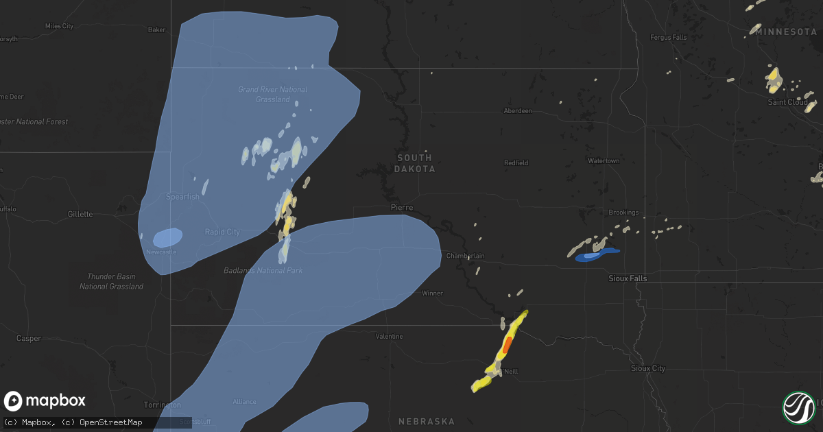
Hail Map in South Dakota on June 6, 2020
Get this storm
June 6 map
$229
one time, instant access
Download today. No call, no setup
Keep the $229
Bought the map and want the full workflow? Apply the entire $229 to a subscription within 7 days. None of it is wasted.
Every map, not just this one
This buys you this map. Subscription and you get every map we run, in the markets you choose from a few cities to whole states to nationwide. Plus real-time alerts the moment a storm fires.
Contact data
Name, contact info, occupancy, even credit band for addresses in the footprint. You go from where it hit to who to call.
Become the source they trust
Unlimited branding weather history reports on demand. You already have the documented answer ready for the property owner, and you are the one who showed up with it.
Property data and RoofTrace estimates
Pull up any address you have got, its value and the exact code rules for that jurisdiction, straight from One Click Code. Then RoofTrace estimates the squares, pitch, and roof value, priced the way you price.
Storm reports in South Dakota
South Dakota
| Date | Description |
|---|---|
| 06/06/20206:49 PM CDT | 4 inch branches broken... Trash dumpster blown away |
| 06/06/20206:49 PM CDT | 4 inch branches broken... Trash dumpster blown away |
| 06/06/20206:44 PM CDT | A local report indicates 75 MPH wind near 8 W JEWEL CAVE |
| 06/06/20206:34 PM CDT | A local report indicates 77 MPH wind near 10 W EDGEMONT |
| 06/06/20206:29 PM CDT | A local report indicates 61 MPH wind near 7 WNW COLTON |
| 06/06/20206:26 PM CDT | A local report indicates 61 MPH wind near 6 E ORLAND |
| 06/06/20206:00 PM CDT | A local report indicates 74 MPH wind near 7 SW ORLAND |
| 06/06/20205:50 PM CDT | Trees down. |
| 06/06/20205:32 PM CDT | Reports of multiple tree branches down in canova... A couple branches in the 6-8 inch diameter range. |
| 06/06/20201:08 PM CDT | A local report indicates 1.00 inch wind near 3 S RAVINIA |
| 06/06/20205:52 AM CDT | At 1052 PM CDT, severe thunderstorms were located along a line extending from near New Everets Resort to near Gettysburg to near Harrold, moving northeast at 55 mph. HAZARD...60 mph wind gusts and penny size hail. SOURCE...Radar indicated. IMPACT...Expect damage to roofs, siding, and trees. Locations impacted include... Gettysburg, Ipswich, Faulkton, Bowdle, Hoven, Roscoe, Hosmer, Harrold, Cresbard, Orient, Lebanon, Akaska, Seneca, Tolstoy, Onaka, Lowry, Miranda, Brentwood Colony, Polo and Stone Lake. |
| 06/06/20205:47 AM CDT | At 1047 PM CDT, severe thunderstorms were located along a line extending from 9 miles north of Lake Sharpe to Medicine Butte to near Hamill, moving northeast at 55 mph. HAZARD...60 mph wind gusts and penny size hail. SOURCE...Radar indicated. IMPACT...Expect damage to roofs, siding, and trees. Locations impacted include... Miller, Lower Brule, Highmore, Fort Thompson, Lyman, Oacoma, St. Lawrence, Reliance, Shelby, Iona, Ree Heights, Burdette, Vayland, Rosehill Dam, Miller Dale Colony, Medicine Butte, Dude Ranch, Etbauer Hill, Lake Sharpe and Gann Valley. |
| 06/06/20205:04 AM CDT | At 1004 PM CDT, severe thunderstorms were located along a line extending from 14 miles east of Westover to near Okreek to 4 miles east of Littleburg, moving east at 45 mph. HAZARD...60 mph wind gusts. SOURCE...Radar indicated. IMPACT...Expect damage to roofs, siding, and trees. Severe thunderstorms will be near... Carter around 1015 PM CDT. Keyapaha around 1020 PM CDT. Witten around 1025 PM CDT. Millboro around 1030 PM CDT. Winner around 1040 PM CDT. Wewela around 1045 PM CDT. |
| 06/06/20204:59 AM CDT | At 958 PM CDT/858 PM MDT/, severe thunderstorms were located along a line extending from 8 miles southwest of Chantier Creek Recreation Area to 6 miles northwest of Vivian to 7 miles south of 5 Mile Corner to near Mosher, moving northeast at 75 mph. HAZARD...60 mph wind gusts and nickel size hail. SOURCE...Radar indicated. IMPACT...Expect damage to roofs, siding, and trees. Locations impacted include... Pierre, Fort Pierre, Lower Brule, Onida, Presho, Fort Thompson, Lyman, Oacoma, Blunt, Kennebec, Reliance, Vivian, Harrold, Iona, Agar, Cedar Creek Rec Area, Fate Dam, Bush'S Landing, Spring Creek Rec Area and Little Bend Rec Area. |
| 06/06/20204:59 AM CDT | At 958 PM CDT, severe thunderstorms were located along a line extending from near Littleburg to 9 miles northeast of Valentine National Wildlife Refuge, moving northeast at 55 mph. HAZARD...70 mph wind gusts. SOURCE...Radar indicated. IMPACT...Expect considerable tree damage. Damage is likely to mobile homes, roofs, and outbuildings. Locations impacted include... Valentine, Ainsworth, Springview, Johnstown, Valentine National Wildlife Refuge, Norden, Crookston, Wood Lake, Bobcat State Wildlife Management Area, Meadville, North River Trail, Sparks, Keller Park State Recreation Area, Smith Falls State Park, Schlagel Creek State Wildlife Management Area, Antelope Peak, Highway 97 crossing the Niobrara River and Big Alkali Lake State Wildlife Management Area.This includes the following highways... Highway 183 between mile markers 194 and 225. Highway 20 between mile markers 179 and 249. Highway 97 between mile markers 126 and 141. Highway 83 between mile markers 181 and 222. Highway 12 between mile markers 1 and 51. |
| 06/06/20204:36 AM CDT | At 936 PM CDT/836 PM MDT/, severe thunderstorms were located along a line extending from near Red Scaffold to near Brown Church, moving northeast at 80 mph. These are very dangerous storms. HAZARD...80 mph wind gusts and nickel size hail. SOURCE...Radar indicated. IMPACT...Flying debris will be dangerous to those caught without shelter. Mobile homes will be heavily damaged. Expect considerable damage to roofs, windows, and vehicles. Extensive tree damage and power outages are likely. Locations impacted include... Eagle Butte, Lantry, South Eagle Butte, White Horse, Mission Ridge, Laplant, Parade, Ridgeview, Sansarc, Tiospaye Topa School, Bear Creek, Green Grass and Lake Oahe. |
| 06/06/20204:35 AM CDT | At 934 PM CDT/834 PM MDT/, severe thunderstorms were located along a line extending from 6 miles north of Haynes to 10 miles east of Shadehill, moving northeast at 55 mph. HAZARD...70 mph wind gusts. SOURCE...Radar indicated. IMPACT...Expect considerable tree damage. Damage is likely to mobile homes, roofs, and outbuildings. Severe thunderstorms will be near... Carson around 930 PM MDT.Other locations impacted by these severe thunderstorms include Leith,Lark, Heil, St. Gertrude and Raleigh. |
| 06/06/20204:21 AM CDT | At 921 PM CDT/821 PM MDT/, severe thunderstorms were located along a line extending from near Nowlin to 9 miles north of Cedar Butte to near Lakeview, moving northeast at 65 mph. HAZARD...70 mph wind gusts and nickel size hail. SOURCE...Trained weather spotters. IMPACT...Expect considerable tree damage. Damage is likely to mobile homes, roofs, and outbuildings. Locations impacted include... Fort Pierre, Murdo, Vivian, Draper, Okaton, Westover, Mission Ridge, Brown Church, Hayes, Wendte, Chantier Creek Recreation Area, Sansarc, Capa, 5 Mile Corner, Van Metre, Bunker and West Shore Rec Area. |
| 06/06/20204:12 AM CDT | At 912 PM MDT, severe thunderstorms were located along a line extending from 7 miles east of Glad Valley to near Green Grass to Lake Oahe, moving north at 70 mph. HAZARD...70 mph wind gusts and nickel size hail. SOURCE...Radar indicated. IMPACT...Expect considerable tree damage. Damage is likely to mobile homes, roofs, and outbuildings. Locations impacted include... Mclaughlin, Timber Lake, Wakpala, Mcintosh, Isabel, Morristown, Firesteel, Watauga, Little Moreau Rec Area, Trail City, Mahto, Swiftbird, Green Grass, Black Horse, Laplant, Kenel, Parade, Ridgeview, Tiospaye Topa School and Swiftbird Day School. |
| 06/06/20203:40 AM CDT | At 840 PM MDT, severe thunderstorms were located along a line extending from 2 miles southwest of Midland to 4 miles north of Cherry Creek to 3 miles southwest of Iron Lightning, moving east at 45 mph. HAZARD...70 mph wind gusts. SOURCE...Radar indicated. IMPACT...Expect considerable tree damage. Damage is likely to mobile homes, roofs, and outbuildings. Severe thunderstorms will be near... Midland around 845 PM MDT. Thunder Butte around 855 PM MDT. Dupree around 900 PM MDT. |
| 06/06/20203:26 AM CDT | At 826 PM MDT/926 PM CDT/, severe thunderstorms were located along a line extending from 8 miles north of Kadoka to 7 miles east of Norris to 6 miles north of Kilgore, moving east at 45 mph. HAZARD...70 mph wind gusts. SOURCE...Radar indicated. IMPACT...Expect considerable tree damage. Damage is likely to mobile homes, roofs, and outbuildings. Severe thunderstorms will be near... Saint Francis and Cedar Butte around 930 PM CDT. Lakeview around 940 PM CDT. White River around 945 PM CDT. Littleburg around 1000 PM CDT. Wood around 1005 PM CDT. Mosher around 1015 PM CDT.This includes Interstate 90 in South Dakota between Mile Markers 151and 174. |
| 06/06/20203:24 AM CDT | At 823 PM MDT, severe thunderstorms were located along a line extending from near Lodgepole to near Red Scaffold, moving northeast at 60 mph. HAZARD...70 mph wind gusts and nickel size hail. SOURCE...Trained weather spotters. IMPACT...Expect considerable tree damage. Damage is likely to mobile homes, roofs, and outbuildings. Locations impacted include... Lantry, Isabel, Morristown, Firesteel, Watauga, Little Moreau Rec Area, Green Grass, Black Horse, Thunder Hawk, Keldron, Bear Creek, Shambo Ranch and Klein Ranch. |
| 06/06/20202:46 AM CDT | At 746 PM MDT, severe thunderstorms were located along a line extending from 5 miles southeast of Opal to 11 miles north of Creighton to 2 miles west of Quinn, moving northeast at 45 mph. HAZARD...60 mph wind gusts. SOURCE...Radar indicated. IMPACT...Expect damage to roofs, siding, and trees. Severe thunderstorms will be near... Grindstone around 805 PM MDT. Howes around 810 PM MDT. Faith, Bridger and Durkee Lake around 815 PM MDT. Grindstone Butte and Takini School around 820 PM MDT. Red Elm around 830 PM MDT. Iron Lightning around 835 PM MDT. Thunder Butte around 845 PM MDT.This includes Interstate 90 in South Dakota between Mile Markers 107and 113. |
| 06/06/20202:30 AM CDT | At 729 PM MDT, severe thunderstorms were located along a line extending from 7 miles north of Whitney Lake to near Sunol, moving east at 50 mph. HAZARD...70 mph wind gusts. SOURCE...Radar indicated. IMPACT...Expect considerable tree damage. Damage is likely to mobile homes, roofs, and outbuildings. Locations impacted include... Alliance, Sidney, Chadron, Bridgeport, Crawford, Hemingford, Lodgepole, Dalton, Gurley, Sunol, Brownson, Alliance Airport, Northport, Angora, Box Butte Dam, Colton, Chadron Campground, Court House And Jail Rocks, Berea and Sidney Airport.This includes Interstate 80 in Nebraska between mile markers 48 and76. |
| 06/06/20202:28 AM CDT | At 728 PM MDT/828 PM CDT/, severe thunderstorms were located along a line extending from Badlands National Park to 3 miles northeast of Kyle to 8 miles northwest of Merriman, moving east at 85 mph. HAZARD...70 mph wind gusts. SOURCE...Radar indicated. IMPACT...Expect considerable tree damage. Damage is likely to mobile homes, roofs, and outbuildings. Severe thunderstorms will be near... Potato Creek, Lacreek Wildlife Refuge and Snake Butte around 735 PM MDT. Tuthill around 740 PM MDT. Wanblee, Vetal and Eagle Nest Butte around 745 PM MDT. Harrington and Pinnacles Ranger Station around 750 PM MDT. Spring Creek and Cedar Pass around 755 PM MDT. Parmelee, Cactus Flat, Cottonwood, Minuteman Missile Visitors Center and Delta 1 Launch Facility around 800 PM MDT. Rosebud around 805 PM MDT.This includes Interstate 90 in South Dakota between Mile Markers 113and 174. |
| 06/06/20201:45 AM CDT | At 644 PM MDT, severe thunderstorms were located along a line extending from 5 miles southwest of Folsom to 8 miles south of Intersection of Red Shirt and Cuny Table Roads to 11 miles north of Chadron Airport, moving east at 50 mph. HAZARD...60 mph wind gusts. SOURCE...Radar indicated. IMPACT...Expect damage to roofs, siding, and trees. Severe thunderstorms will be near... Slim Buttes around 700 PM MDT. Oglala and Rockyford around 710 PM MDT. Pine Ridge and Sharps Corner around 715 PM MDT. Badlands National Park around 720 PM MDT. Kyle around 730 PM MDT. Porcupine around 735 PM MDT. Potato Creek and Batesland around 745 PM MDT.This includes Interstate 90 in South Dakota between Mile Markers 130and 131. |
| 06/06/20201:42 AM CDT | At 642 PM MDT, severe thunderstorms were located along a line extending from 6 miles east of Bear Butte State Park to 2 miles northeast of Box Elder to 5 miles southwest of Folsom, moving northeast at 55 mph. HAZARD...70 mph wind gusts. SOURCE...Radar indicated. IMPACT...Expect considerable tree damage. Damage is likely to mobile homes, roofs, and outbuildings. Severe thunderstorms will be near... Hereford around 700 PM MDT. Owanka and Elm Springs around 710 PM MDT. Wasta around 720 PM MDT. White Owl around 730 PM MDT. Creighton around 735 PM MDT. Plainview and Marcus around 740 PM MDT.This includes Interstate 90 in South Dakota between Mile Markers 36and 130. |
| 06/06/20201:16 AM CDT | At 615 PM MDT, severe thunderstorms were located along a line extending from 8 miles northwest of Box Butte Campground to Alliance Airport to 13 miles west of Crescent Lake National Wildlife Refuge, moving northeast at 60 mph. HAZARD...70 mph wind gusts. SOURCE...Radar indicated. IMPACT...Expect considerable tree damage. Damage is likely to mobile homes, roofs, and outbuildings. Locations impacted include... Gordon, Rushville, Hay Springs, Ellsworth, White Clay, Ashby, Antioch, Clinton, Intersection of Highway 87 and Craven Creek Road, Big Hill, Dipping Vat Meadow, Billys Lake, Lone Butte, Irwin, Intersection of Beaver Creek Road and White Clay Creek Road, Intersection of Highway 87 and Larabee Road, Rock Hill, Pine Ridge, Hoover Lake and Wickson Lake.This includes the following highways... Highway 20 between mile markers 74 and 129. Highway 250 between mile markers 1 and 48. Highway 2 between mile markers 96 and 137. |
| 06/06/20201:05 AM CDT | At 604 AM CDT, a severe thunderstorm was located 7 miles southwest of Geddes, or 12 miles west of Lake Andes, moving northeast at 30 mph. HAZARD...Quarter size hail. SOURCE...Radar indicated. IMPACT...Damage to vehicles is expected. This severe thunderstorm will be near... Geddes around 620 AM CDT. Lake Andes around 625 AM CDT. |
| 06/06/20201:01 AM CDT | At 601 PM CDT, severe thunderstorms were located along a line extending from near Winfred to 8 miles southwest of Orland to near Salem, moving east at 25 mph. HAZARD...60 mph wind gusts and quarter size hail. SOURCE...Radar indicated. IMPACT...Hail damage to vehicles is expected. Expect wind damage to roofs, siding, and trees. Severe thunderstorms will be near... Lake Herman State Park, Ramona and Orland around 620 PM CDT. Montrose around 625 PM CDT. Madison around 630 PM CDT. Humboldt around 635 PM CDT. Colton, Wentworth, Chester and Nunda around 645 PM CDT. |
| 06/06/202012:12 AM CDT | At 512 PM CDT, a severe thunderstorm was located 7 miles west of Canova, or 21 miles northeast of Mitchell, moving north at 35 mph. HAZARD...60 mph wind gusts and half dollar size hail. SOURCE...Radar indicated. IMPACT...Hail damage to vehicles is expected. Expect wind damage to roofs, siding, and trees. This severe thunderstorm will be near... Canova around 515 PM CDT. Vilas and Roswell around 525 PM CDT. Howard around 530 PM CDT. |
| 06/05/202010:45 PM CDT | 10 unit storage shed destroyed. Back wall pushed over and metal spread downwind up to a quarter mile away. Boats inside were not moved. Time estimated from radar. |
| 06/05/202010:40 PM CDT | A local report indicates 64 MPH wind near 2 W HAMILL |
| 06/05/202010:37 PM CDT | Gravel being lifted off the road by the wind. |
| 06/05/202010:32 PM CDT | Estimated 60 mph winds. An olive tree was blown down too. Time estimated on radar. |
| 06/05/202010:27 PM CDT | Asos station kpir pierre muni ap. |
| 06/05/202010:20 PM CDT | Time estimated from radar. |
| 06/05/202010:20 PM CDT | Mesonet station rfps2 vivian 13 n. |
| 06/05/202010:06 PM CDT | Time between 907pm and 1006pm. |
| 06/05/20209:56 PM CDT | A davis weather station measured a gust of 94 mph. Largest tree branch down was about 10 inches in diameter. |
| 06/05/20209:56 PM CDT | Report from mping: 1-inch tree limbs broken; shingles blown off. Time estimated from radar. |
| 06/05/20209:50 PM CDT | A local report indicates 70 MPH wind near 14 SSE DUPREE |
| 06/05/20209:45 PM CDT | A local report indicates 60 MPH wind near SHADEHILL |
| 06/05/20209:45 PM CDT | A local report indicates 60 MPH wind near 7 ESE ROSEBUD |
| 06/05/20209:42 PM CDT | 18-wheeler blown off i-90 and into the median. |
| 06/05/20209:42 PM CDT | Metal roof torn off building. |
| 06/05/20209:39 PM CDT | A local report indicates 58 MPH wind near 1 ENE MUD BUTTE |
| 06/05/20209:34 PM CDT | A local report indicates 71 MPH wind near 9 ENE BELVIDERE |
| 06/05/20209:34 PM CDT | A local report indicates 70 MPH wind near 1 NE MIDLAND |
| 06/05/20209:34 PM CDT | A local report indicates 61 MPH wind near 3 W LEMMON |
| 06/05/20209:30 PM CDT | A local report indicates 72 MPH wind near 2 SW BRIDGER |
| 06/05/20209:28 PM CDT | A local report indicates 58 MPH wind near 6 W PARMELEE |
| 06/05/20209:25 PM CDT | A local report indicates 75 MPH wind near 1 NNE FAITH |
| 06/05/20209:20 PM CDT | A local report indicates 60 MPH wind near 16 WNW MILESVILLE |
| 06/05/20209:19 PM CDT | Conferred with storm chasers to verify existence of weak... Brief tornado. A vehicle and attached camper were lifted and flipped upside down. There are no known fatalit |
| 06/05/20209:16 PM CDT | A local report indicates 65 MPH wind near 5 ESE NORRIS |
| 06/05/20209:15 PM CDT | A local report indicates 72 MPH wind near 3 W FAITH |
| 06/05/20209:08 PM CDT | A local report indicates 60 MPH wind near 10 ESE ZEONA |
| 06/05/20209:05 PM CDT | A local report indicates 74 MPH wind near 7 E WANBLEE |
| 06/05/20209:04 PM CDT | A local report indicates 59 MPH wind near 11 SW PARMELEE |
| 06/05/20209:03 PM CDT | Two semi-trailer trucks flipped on i-90 at mm141 and mm143. |
| 06/05/20209:03 PM CDT | Two semi-trailer trucks flipped on i-90 at mm121 and mm123. |
| 06/05/20209:00 PM CDT | A local report indicates 70 MPH wind near 2 E COTTONWOOD |
| 06/05/20208:59 PM CDT | A local report indicates 92 MPH wind near 4 E CACTUS FLAT |
| 06/05/20208:58 PM CDT | 76 mph wind gust measured... With sustained winds at 55 mph for two minutes. Measured with vehicle mounted anemometer. |
| 06/05/20208:56 PM CDT | A local report indicates 60 MPH wind near 2 ENE WHITE OWL |
| 06/05/20208:54 PM CDT | A local report indicates 68 MPH wind near 3 NW WASTA |
| 06/05/20208:54 PM CDT | A local report indicates 64 MPH wind near 4 E CACTUS FLAT |
| 06/05/20208:53 PM CDT | Brief weak tornado did damage to a campground. One cabin was torn from the foundation. |
| 06/05/20208:53 PM CDT | A local report indicates 70 MPH wind near 8 SE INTERIOR |
| 06/05/20208:43 PM CDT | Brief weak tornado did damage to a campground. One cabin was torn from the foundation. |
| 06/05/20208:35 PM CDT | A local report indicates 60 MPH wind near 1 N CAMP CROOK |
| 06/05/20208:33 PM CDT | A local report indicates 78 MPH wind near 1 N BUFFALO |
| 06/05/20208:33 PM CDT | A local report indicates 60 MPH wind near KYLE |
| 06/05/20208:25 PM CDT | A local report indicates 79 MPH wind near 5 NE PORCUPINE |
| 06/05/20208:24 PM CDT | A local report indicates 77 MPH wind near 8 N REDIG |
| 06/05/20208:19 PM CDT | A local report indicates 68 MPH wind near 8 N REDIG |
| 06/05/20208:19 PM CDT | A local report indicates 58 MPH wind near 3 W UNION CENTER |
| 06/05/20208:15 PM CDT | A local report indicates 64 MPH wind near 9 SW BATESLAND |
| 06/05/20208:11 PM CDT | A local report indicates 70 MPH wind near 3 SE DWTN SPEARFISH |
| 06/05/20208:10 PM CDT | At 109 PM CDT, a severe thunderstorm was located near Ravinia, or 7 miles east of Pickstown, moving northeast at 25 mph. HAZARD...Ping pong ball size hail and 60 mph wind gusts. SOURCE...Radar indicated. IMPACT...People and animals outdoors will be injured. Expect hail damage to roofs, siding, windows, and vehicles. Expect wind damage to roofs, siding, and trees. This severe thunderstorm will be near... Wagner around 120 PM CDT. |
| 06/05/20208:09 PM CDT | A local report indicates 62 MPH wind near 3 ESE PINE RIDGE |
| 06/05/20208:05 PM CDT | A local report indicates 60 MPH wind near 1 WNW OGLALA |
| 06/05/20208:00 PM CDT | A local report indicates 63 MPH wind near 5 WNW NEW UNDERWOOD |
| 06/05/20207:57 PM CDT | A local report indicates 67 MPH wind near RAPID CITY ARPT |
| 06/05/20207:56 PM CDT | A local report indicates 66 MPH wind near 27 WNW CASTLE ROCK |
| 06/05/20207:55 PM CDT | A local report indicates 81 MPH wind near 3 SE NEWELL |
| 06/05/20207:54 PM CDT | A local report indicates 58 MPH wind near 12 E OELRICHS |
| 06/05/20207:44 PM CDT | A local report indicates 71 MPH wind near 12 WSW CASTLE ROCK |
| 06/05/20207:44 PM CDT | A local report indicates 63 MPH wind near 12 E OELRICHS |
| 06/05/20207:43 PM CDT | A local report indicates 60 MPH wind near 2 NE DWTN RAPID CITY |
| 06/05/20207:43 PM CDT | A local report indicates 67 MPH wind near RAPID CITY ARPT |
| 06/05/20207:40 PM CDT | A local report indicates 63 MPH wind near 1 NNW NISLAND |
| 06/05/20207:39 PM CDT | A local report indicates 58 MPH wind near 12 E OELRICHS |
| 06/05/20207:39 PM CDT | A local report indicates 74 MPH wind near ELLSWORTH AFB |
| 06/05/20207:36 PM CDT | A local report indicates 70 MPH wind near 4 SSW DWTN RAPID CITY |
| 06/05/20207:35 PM CDT | A local report indicates 72 MPH wind near 4 E DWTN SPEARFISH |
| 06/05/20207:34 PM CDT | A local report indicates 71 MPH wind near 3 WSW FAIRBURN |
| 06/05/20207:34 PM CDT | A local report indicates 94 MPH wind near 13 NW BELLE FOURCHE |
| 06/05/20207:30 PM CDT | A local report indicates 67 MPH wind near 4 S DWTN RAPID CITY |
| 06/05/20207:24 PM CDT | A local report indicates 65 MPH wind near 3 WSW FAIRBURN |
| 06/05/20207:24 PM CDT | A local report indicates 63 MPH wind near HILL CITY |
| 06/05/20207:20 PM CDT | A local report indicates 59 MPH wind near 5 SW BROWNSVILLE |
| 06/05/20207:20 PM CDT | A local report indicates 60 MPH wind near 4 N SILVER CITY |
| 06/05/20207:19 PM CDT | A local report indicates 66 MPH wind near 4 N SILVER CITY |
| 06/05/20207:15 PM CDT | A local report indicates 58 MPH wind near 4 NNE ANGOSTURA RES |
| 06/05/20207:15 PM CDT | A local report indicates 74 MPH wind near DWTN SPEARFISH |
| 06/05/20207:15 PM CDT | A local report indicates 67 MPH wind near 1 E LEAD |
| 06/05/20207:14 PM CDT | A local report indicates 63 MPH wind near 4 N SILVER CITY |
| 06/05/20207:10 PM CDT | A local report indicates 59 MPH wind near 5 SW BROWNSVILLE |
| 06/05/20207:09 PM CDT | A local report indicates 63 MPH wind near 3 S FLANDREAU |
| 06/05/20207:08 PM CDT | A local report indicates 58 MPH wind near 6 W ROCHFORD |
| 06/05/20207:02 PM CDT | A local report indicates 63 MPH wind near 2 SSW CUSTER |
All States Impacted by Hail Map on June 6, 2020
Cities Impacted by Hail Map on June 6, 2020
- Flandreau, SD
- Colman, SD
- Rye, CO
- Faith, SD
- Canterbury, CT
- Windham, CT
- Baltic, CT
- Jewett City, CT
- Atkinson, NE
- Stuart, NE
- Denmark, ME
- Fryeburg, ME
- Left Hand, WV
- Clendenin, WV
- Amma, WV
- Millville, MA
- Uxbridge, MA
- Backus, MN
- Pine River, MN
- Cahone, CO
- Blanding, UT
- Lake Powell, UT
- Armour, SD
- Corsica, SD
- Louisa, KY
- Dolores, CO
- Jordan, MN
- Vernal, UT
- Thompson, UT
- Patriot, OH
- Gallipolis, OH
- Wolford, ND
- Port Haywood, VA
- Susan, VA
- Becker, MN
- Princeton, MN
- Flasher, ND
- Auburn, MA
- Worcester, MA
- North Grafton, MA
- Millbury, MA
- Bowling Green, VA
- Woodford, VA
- Tappahannock, VA
- Newtown, VA
- Fredericksburg, VA
- Walkerton, VA
- Bruington, VA
- Aylett, VA
- Saint Stephens Church, VA
- Milford, VA
- Port Royal, VA
- Ruther Glen, VA
- Dupree, SD
- Bristow, NE
- Oneill, NE
- Spencer, NE
- Harts, WV
- Chapmanville, WV
- Edison, NE
- Elwood, NE
- Arapahoe, NE
- Goodrich, ND
- Cobbs Creek, VA
- Gloucester, VA
- North, VA
- Dutton, VA
- Hartfield, VA
- Marlborough, CT
- Lake George, CO
- Grayson, KY
- Webbville, KY
- Hitchins, KY
- Wall, SD
- Mekinock, ND
- Quinn, SD
- Howes, SD
- Wasta, SD
- Scenic, SD
- Little Falls, MN
- Escalante, UT
- Sauk Rapids, MN
- Cayuga, ND
- Lidgerwood, ND
- Warwick, ND
- New Rockford, ND
- Upton, MA
- Cortez, CO
- Bowlus, MN
- Holdingford, MN
- Hensel, ND
- Cavalier, ND
- Clewiston, FL
- Holden, WV
- Logan, WV
- Dunlow, WV
- Genoa, WV
- Monticello, UT
- Denhoff, ND
- Bemidji, MN
- Looneyville, WV
- Newton, WV
- Plummer, MN
- Minot, ND
- Northwood, ND
- West Brookfield, MA
- North Brookfield, MA
- Warren, MA
- Ireland, WV
- Reeder, ND
- Royalton, MN
- Rice, MN
- Saint Joseph, MN
- Avon, MN
- Glenwood, WV
- Crown City, OH
- Fairfax, SD
- Lynch, NE
- Poland, ME
- Naples, ME
- New Gloucester, ME
- Casco, ME
- Raymond, ME
- Verndale, MN
- Staples, MN
- Hazen, ND
- Hesperus, CO
- Las Vegas, NM
- Tinnie, NM
- Capitan, NM
- Upton, WY
- Mott, ND
- Culloden, WV
- Ranger, WV
- Mud Butte, SD
- Veblen, SD
- Medfield, MA
- Walpole, MA
- Dover, MA
- Griffithsville, WV
- Hamlin, WV
- Yawkey, WV
- Hurricane, WV
- Sod, WV
- Deep River, CT
- Killingworth, CT
- Bertrand, NE
- Spencer, WV
- Melfa, VA
- Wagner, SD
- Lake Andes, SD
- Pueblo, CO
- Hebron, ND
- Rush City, MN
- Grantsburg, WI
- Almont, ND
- Foley, MN
- Mathews, VA
- Cardinal, VA
- Bohannon, VA
- Foster, VA
- Boswell, OK
- Rock Cave, WV
- Lenore, WV
- Breeden, WV
- Wilsondale, WV
- Kermit, WV
- Union Center, SD
- Selden, KS
- Warsaw, VA
- Mcville, ND
- Isle, MN
- Aitkin, MN
- Carson, ND
- Ellamore, WV
- Coalton, WV
- Labelle, FL
- Pagosa Springs, CO
- Voltaire, ND
- Cherry Creek, SD
- Cohagen, MT
- Terry, MT
- Branchland, WV
- Salt Rock, WV
- Barboursville, WV
- Bolton, MA
- Stow, MA
- Sudbury, MA
- Hudson, MA
- Maddock, ND
- Bigfork, MN
- Milton, WV
- Rosebud, MT
- Hathaway, MT
- Bethel, MN
- Stacy, MN
- Isanti, MN
- Oakes, ND
- North Platte, NE
- Garrison, ND
- Ryder, ND
- Berwick, ME
- North Berwick, ME
- Ogunquit, ME
- Wells, ME
- South Berwick, ME
- Holland, MN
- Big Bend, WV
- Grace City, ND
- Meadow, SD
- Jericho, NY
- Elkton, SD
- Circle, MT
- Sartell, MN
- Ocate, NM
- North Franklin, CT
- South Windham, CT
- Alkol, WV
- Danville, WV
- Julian, WV
- Gettysburg, SD
- Geddes, SD
- Motley, MN
- Pine City, MN
- Deer River, MN
- Spring Lake, MN
- Max, MN
- Douglas, ND
- Kinsey, MT
- Wyndmere, ND
- Belle Plaine, MN
- Carver, MN
- Pipestone, MN
- Center, CO
- Moffat, CO
- Balaton, MN
- Ruthton, MN
- Cumberland, RI
- Esmond, ND
- Mcclusky, ND
- Zap, ND
- Valmora, NM
- Watrous, NM
- Emerado, ND
- Bridgton, ME
- Argyle, MN
- Alvarado, MN
- Oslo, MN
- Manvel, ND
- Grand Forks Afb, ND
- Webster Springs, WV
- Cowen, WV
- Shakopee, MN
- Sanbornville, NH
- Shapleigh, ME
- Acton, ME
- Winfred, SD
- Sutton, MA
- Charlton, MA
- Rochdale, MA
- Oxford, MA
- North Oxford, MA
- Tyler, MN
- Gilby, ND
- Minto, ND
- Harrisville, RI
- North Smithfield, RI
- Douglas, MA
- Nisland, SD
- Vale, SD
- Whitewood, SD
- Newell, SD
- Sawyer, OK
- Park Rapids, MN
- Ona, WV
- Alamo, ND
- Slatersville, RI
- Leicester, MA
- Blackstone, MA
- Wrentham, MA
- Franklin, MA
- Brookfield, MA
- Spencer, MA
- Whitinsville, MA
- Bellingham, MA
- Mendon, MA
- East Brookfield, MA
- Woonsocket, RI
- Forestdale, RI
- Rugby, ND
- Madison, SD
- Topping, VA
- Saluda, VA
- Locust Hill, VA
- Hershey, NE
- Brookings, SD
- Nevis, MN
- Sutton, WV
- Prichard, WV
- Menahga, MN
- Atoka, OK
- Snowville, UT
- West Hamlin, WV
- Max, ND
- Harvey, ND
- East Wakefield, NH
- Wolfeboro, NH
- Aurora, ME
- Ellsworth, ME
- Butte, NE
- Mapleton, ND
- Gann Valley, SD
- Hettinger, ND
- Arthur City, TX
- Walker, MN
- Powderly, TX
- Beulah, ND
- Walton, WV
- Hayes, VA
- Sauk Centre, MN
- Osakis, MN
- West Union, MN
- Dingess, WV
- Hackensack, MN
- Forest River, ND
- Deltaville, VA
- Norcross, MN
- Lemmon, SD
- Wentworth, SD
- Rutland, SD
- Mcgregor, ND
- Heathsville, VA
- Kilmarnock, VA
- Lignite, ND
- Portal, ND
- Elbow Lake, MN
- Columbus, ND
- Crosby, ND
- Saint Francis, MN
- Cedar, MN
- Wagon Mound, NM
- Ashton, WV
- Apple Grove, WV
- Emmet, NE
- Amelia, NE
- Granville, ND
- Towner, ND
- Ray, ND
- Tioga, ND
- Wallace, NE
- Duck, WV
- Clay, WV
- Carrington, ND
- Oak Park, MN
- Onancock, VA
- Shacklefords, VA
- West Point, VA
- Mattaponi, VA
- Chamberlain, SD
- Pilgrim, KY
- Inez, KY
- Leonard, ND
- Kindred, ND
- Volga, SD
- Nunda, SD
- Park Valley, UT
- Gothenburg, NE
- Cozad, NE
- Spencer, SD
- Howard, SD
- Alexandria, SD
- Canova, SD
- Le Roy, WV
- Reedy, WV
- Centerbrook, CT
- Ivoryton, CT
- Essex, CT
- Underwood, ND
- Plainfield, CT
- Moosup, CT
- King William, VA
- Spotsylvania, VA
- Stevensville, VA
- Montross, VA
- Colonial Beach, VA
- Tornado, WV
- Albany, MN
- Pukwana, SD
- Platte, SD
- Manquin, VA
- Proctorville, OH
- Chesapeake, OH
- Wayne, WV
- Fort Gay, WV
- Lancaster, VA
- Farnham, VA
- Sanbornton, NH
- Enning, SD
- White Owl, SD
- Ross, ND
- Stanley, ND
- Trail, MN
- Vanceburg, KY
- Garrison, KY
- Stout, OH
- Blue Creek, OH
- Turtle Creek, WV
- Hewett, WV
- Wallback, WV
- Procious, WV
- Hudgins, VA
- Hallieford, VA
- Diggs, VA
- Moon, VA
- Wake, VA
- Onemo, VA
- Larimore, ND
- New Prague, MN
- Orma, WV
- Powers Lake, ND
- Tilton, NH
- Franklin, NH
- White Stone, VA
- Irvington, VA
- Weems, VA
- Aneta, ND
- New Kent, VA
- Mechanicsville, VA
- Arvilla, ND
- Richardton, ND
- Edmore, ND
- Fairdale, ND
- Ruso, ND
- Monte Vista, CO
- Maynard, MA
- Marlborough, MA
- Crum, WV
- Omar, WV
- Switzer, WV
- Eureka, SD
- Elko New Market, MN
- Prior Lake, MN
- Wellesley, MA
- Natick, MA
- Weston, MA
- Wayland, MA
- Wellesley Hills, MA
- Keldron, SD
- Hurdsfield, ND
- Glen Ullin, ND
- Clear Lake, MN
- Belle Fourche, SD
- Cambridge, MN
- Huntington, WV
- Pickens, WV
- Yorktown, VA
- Sterling, MA
- Clinton, MA
- Lancaster, MA
- Fairmount, ND
- Cologne, MN
- Chaska, MN
- Langford, SD
- Pierpont, SD
- Karlsruhe, ND
- Bagley, MN
- Bottineau, ND
- North Branch, MN
- Attleboro, MA
- Mansfield, MA
- North Attleboro, MA
- Northbridge, MA
- Sturbridge, MA
- Fiskdale, MA
- Norton, MA
- Attleboro Falls, MA
- Plainville, MA
- Brimfield, MA
- Canton, MA
- Dedham, MA
- Westwood, MA
- Norwood, MA
- Milton, MA
- Randolph, MA
- Quincy, MA
- Alfred, ME
- Waterboro, ME
- Bluff, UT
- Orlando, FL
- Longwood, FL
- Altamonte Springs, FL
- Winter Park, FL
- Deltona, FL
- Ormond Beach, FL
- Lake Mary, FL
- Winter Springs, FL
- Casselberry, FL
- Deland, FL
- Maitland, FL
- Daytona Beach, FL
- Sanford, FL
- Lake Helen, FL
- Debary, FL
- Orange City, FL
- De Leon Springs, FL
- Palm Coast, FL
- Bunnell, FL
- Apopka, FL
- Ocoee, FL
- Clearwater, FL
- Louviers, CO
- Dupont, CO
- Arvada, CO
- Bailey, CO
- Morrison, CO
- Sterling, CO
- Evergreen, CO
- Log Lane Village, CO
- Brush, CO
- Louisville, CO
- Bennett, CO
- Weldona, CO
- Conifer, CO
- Frederick, CO
- Fort Morgan, CO
- Akron, CO
- Roggen, CO
- Westminster, CO
- Littleton, CO
- Byers, CO
- Sedalia, CO
- Lone Tree, CO
- Watkins, CO
- Hillrose, CO
- Englewood, CO
- Lafayette, CO
- Indian Hills, CO
- Kittredge, CO
- Henderson, CO
- Pine, CO
- Strasburg, CO
- Commerce City, CO
- Golden, CO
- Brighton, CO
- Erie, CO
- Keenesburg, CO
- Snyder, CO
- Orchard, CO
- Aurora, CO
- Atwood, CO
- Thornton, CO
- Castle Rock, CO
- Merino, CO
- Broomfield, CO
- Parker, CO
- Idledale, CO
- Denver, CO
- Stoneham, CO
- Wheat Ridge, CO
- Wiggins, CO
- Fort Lupton, CO
- Hudson, CO
- Buffalo Creek, CO
- Dacono, CO
- Meriden, WY
- Batesland, SD
- Carpenter, WY
- Wounded Knee, SD
- Long Valley, SD
- Mcgrew, NE
- Chadron, NE
- Presho, SD
- Hemingford, NE
- Lower Brule, SD
- Kyle, SD
- Potter, NE
- Vivian, SD
- Okreek, SD
- Bushnell, NE
- Mitchell, NE
- Draper, SD
- Angora, NE
- Yoder, WY
- Saint Francis, SD
- Reliance, SD
- Bayard, NE
- Parmelee, SD
- Melbeta, NE
- Scottsbluff, NE
- Belvidere, SD
- Pine Bluffs, WY
- Okaton, SD
- Hay Springs, NE
- Oglala, SD
- Lakeside, NE
- White River, SD
- Kennebec, SD
- Rushville, NE
- Albin, WY
- Murdo, SD
- Alliance, NE
- Hawk Springs, WY
- Midland, SD
- Gordon, NE
- Wanblee, SD
- Winner, SD
- Hamill, SD
- Wood, SD
- Ellsworth, NE
- Bridgeport, NE
- Dix, NE
- Glen Haven, CO
- Minatare, NE
- Wellington, CO
- Rosebud, SD
- Hereford, CO
- Cody, NE
- Bellvue, CO
- Harrison, NE
- Nunn, CO
- Merriman, NE
- Martin, SD
- Marsland, NE
- Crawford, NE
- Gering, NE
- Kadoka, SD
- Fort Collins, CO
- Lagrange, WY
- Caputa, SD
- Manderson, SD
- Bingham, NE
- Mission, SD
- Morrill, NE
- Ault, CO
- Burns, WY
- Carr, CO
- Lyman, NE
- Ideal, SD
- Tuthill, SD
- Ashby, NE
- Interior, SD
- Allen, SD
- Whitney, NE
- Philip, SD
- Oelrichs, SD
- Grover, CO
- Drake, CO
- Witten, SD
- Torrington, WY
- Loveland, CO
- Fort Pierre, SD
- Harrisburg, NE
- Cheyenne, WY
- Hillsdale, WY
- Norris, SD
- Kimball, NE
- Laporte, CO
- Pine Ridge, SD
- Porcupine, SD
- Ward, CO
- Johnstown, CO
- Windsor, CO
- Berthoud, CO
- Lyons, CO
- Timnath, CO
- Boulder, CO
- Eaton, CO
- Longmont, CO
- Jamestown, CO
- Pierce, CO
- Severance, CO
- Elizabeth, CO
- Agate, CO
- Matheson, CO
- Divide, CO
- Franktown, CO
- Peyton, CO
- Usaf Academy, CO
- Palmer Lake, CO
- Elbert, CO
- Ramah, CO
- Rush, CO
- Cripple Creek, CO
- Colorado Springs, CO
- Kiowa, CO
- Simla, CO
- Larkspur, CO
- Green Mountain Falls, CO
- Yoder, CO
- Victor, CO
- Manitou Springs, CO
- Penrose, CO
- Woodland Park, CO
- Florissant, CO
- Deer Trail, CO
- Cascade, CO
- Fountain, CO
- Calhan, CO
- Monument, CO
- Limon, CO
- Canon City, CO
- Guffey, CO
- Hugo, CO
- Boone, CO
- Avondale, CO
- Chappell, NE
- Dalton, NE
- Oshkosh, NE
- Mullen, NE
- Whitman, NE
- Tryon, NE
- Hyannis, NE
- Lodgepole, NE
- Gurley, NE
- Sidney, NE
- Arthur, NE
- Lewellen, NE
- Padroni, CO
- Lemoyne, NE
- Lisco, NE
- Peetz, CO
- Broadwater, NE
- Alzada, MT
- Raleigh, ND
- Newcastle, WY
- Prairie City, SD
- Amidon, ND
- Deadwood, SD
- Black Hawk, SD
- Hill City, SD
- Aladdin, WY
- Hulett, WY
- Fort Meade, SD
- Osage, WY
- Marmarth, ND
- Selfridge, ND
- Hermosa, SD
- Bison, SD
- Ekalaka, MT
- New England, ND
- McLaughlin, SD
- Edgemont, SD
- Alva, WY
- Ralph, SD
- Elgin, ND
- McIntosh, SD
- Nemo, SD
- Sturgis, SD
- Rapid City, SD
- Saint Onge, SD
- Isabel, SD
- Regent, ND
- Spearfish, SD
- Scranton, ND
- Watauga, SD
- Beulah, WY
- Owanka, SD
- Ludlow, SD
- Ellsworth Afb, SD
- Sundance, WY
- Piedmont, SD
- Eagle Butte, SD
- Timber Lake, SD
- New Underwood, SD
- Morristown, SD
- Moorcroft, WY
- Lead, SD
- New Leipzig, ND
- Capitol, MT
- Lodgepole, SD
- Box Elder, SD
- Bowman, ND
- Buffalo, SD
- Rhame, ND
- Custer, SD
- Camp Crook, SD
- Keystone, SD
- Reva, SD
- Dell Rapids, SD
- Colton, SD
- Salem, SD
- Montrose, SD
- Chester, SD


