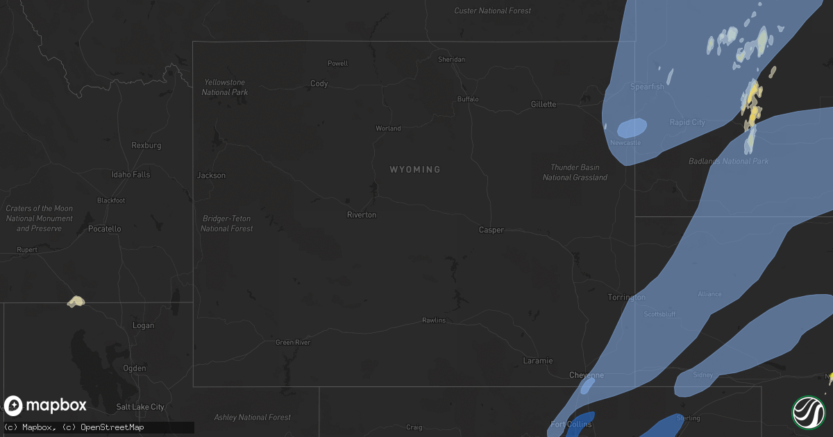
Hail Map in Wyoming on June 6, 2020
Get this storm
June 6 map
$229
one time, instant access
Download today. No call, no setup
Keep the $229
Bought the map and want the full workflow? Apply the entire $229 to a subscription within 7 days. None of it is wasted.
Every map, not just this one
This buys you this map. Subscription and you get every map we run, in the markets you choose from a few cities to whole states to nationwide. Plus real-time alerts the moment a storm fires.
Contact data
Name, contact info, occupancy, even credit band for addresses in the footprint. You go from where it hit to who to call.
Become the source they trust
Unlimited branding weather history reports on demand. You already have the documented answer ready for the property owner, and you are the one who showed up with it.
Property data and RoofTrace estimates
Pull up any address you have got, its value and the exact code rules for that jurisdiction, straight from One Click Code. Then RoofTrace estimates the squares, pitch, and roof value, priced the way you price.
Storm reports in Wyoming
Wyoming
| Date | Description |
|---|---|
| 06/06/20206:49 PM CDT | A local report indicates 64 MPH wind near 8 NW ROCKYPOINT |
| 06/06/20206:42 PM CDT | A local report indicates 64 MPH wind near 10 ESE PINE HAVEN |
| 06/06/20206:40 PM CDT | Mental dumpster mangled. |
| 06/06/20206:38 PM CDT | A local report indicates 70 MPH wind near 6 ESE CLARETON |
| 06/06/20206:35 PM CDT | A local report indicates 60 MPH wind near 6 WNW NEWCASTLE |
| 06/06/20206:34 PM CDT | A local report indicates 61 MPH wind near PINE HAVEN |
| 06/06/20206:30 PM CDT | Power outage with trees blown down for much of torrington... Wy. |
| 06/06/20206:27 PM CDT | Power outage. |
| 06/06/20206:27 PM CDT | . |
| 06/06/20206:26 PM CDT | A local report indicates 74 MPH wind near 6 SW YODER |
| 06/06/20206:22 PM CDT | A local report indicates 78 MPH wind near 1 NE ECHETA |
| 06/06/20206:20 PM CDT | A local report indicates 62 MPH wind near 4 SE DWTN GILLETTE |
| 06/06/20206:16 PM CDT | Corrects previous tstm wnd gst report from gun barrel. Mesonet station kgun gun barrel |
| 06/06/20206:15 PM CDT | Some large tree branches down. |
| 06/06/20206:15 PM CDT | A local report indicates 64 MPH wind near 3 E DWTN GILLETTE |
| 06/06/20206:15 PM CDT | A local report indicates 65 MPH wind near 19 SW UPTON |
| 06/06/20206:15 PM CDT | A local report indicates 60 MPH wind near 7 WNW CLARETON |
| 06/06/20206:13 PM CDT | A local report indicates 74 MPH wind near 5 NNW DWTN GILLETTE |
| 06/06/20206:12 PM CDT | A local report indicates 64 MPH wind near 16 WSW DWTN GILLETTE |
| 06/06/20206:08 PM CDT | A local report indicates 60 MPH wind near 4 N ROCHELLE |
| 06/06/20206:06 PM CDT | A local report indicates 78 MPH wind near 16 WSW DWTN GILLETTE |
| 06/06/20206:06 PM CDT | A local report indicates 64 MPH wind near 13 NNE WRIGHT |
| 06/06/20206:05 PM CDT | A local report indicates 74 MPH wind near 25 ESE WRIGHT |
| 06/06/20206:02 PM CDT | A local report indicates 78 MPH wind near 16 WSW DWTN GILLETTE |
| 06/06/20206:02 PM CDT | A local report indicates 64 MPH wind near 13 NNE WRIGHT |
| 06/06/20205:56 PM CDT | A local report indicates 70 MPH wind near 16 WSW DWTN GILLETTE |
| 06/06/20205:55 PM CDT | Awos station k82v pine bluffs airport - 82v. |
| 06/06/20205:52 PM CDT | Dead horse wydot anemometer |
| 06/06/20205:52 PM CDT | Mesonet station estw4 23 s douglas - esterbrook raws - ebk. |
| 06/06/20205:52 PM CDT | Mesonet station kgun gun barrel |
| 06/06/20205:52 PM CDT | Wind gusts 60 to 75 mph beginning at 448 pm at the indian creek wydot anemometer |
| 06/06/20205:46 PM CDT | A local report indicates 58 MPH wind near 17 WSW WRIGHT |
| 06/06/20205:40 PM CDT | Coleman mesonet site along i25-us26-us87 wind gust of 79mph. |
| 06/06/20205:37 PM CDT | A local report indicates 64 MPH wind near SAVAGETON |
| 06/06/20205:35 PM CDT | Kdgw. |
| 06/06/20205:32 PM CDT | Corrects previous tstm wnd gst report from 1 sse bordeaux. Kbrx i-25/us87. |
| 06/06/20205:32 PM CDT | A local report indicates 69 MPH wind near 17 WSW WRIGHT |
| 06/06/20205:30 PM CDT | Wy46 i-80/us30 cheyenne east. |
| 06/06/20205:28 PM CDT | . |
| 06/06/20205:25 PM CDT | Mesonet station up166 8.4 e north cheyenne |
| 06/06/20205:23 PM CDT | Estimated report of 65-70 mph from a trained spotter. |
| 06/06/20205:19 PM CDT | Mesonet station cw2749 cheyenne. |
| 06/06/20205:18 PM CDT | Corrects previous tstm wnd gst report from 6 ene cheyenne. |
| 06/06/20205:16 PM CDT | Mesonet station kgun gun barrel |
| 06/06/20205:16 PM CDT | Mesonet station kwyh 6.5 n natural fort |
| 06/06/20205:13 PM CDT | Deer creek 1-25 wy dot. |
| 06/06/20205:12 PM CDT | Tidsdale divide wydot anemometer |
| 06/06/20205:08 PM CDT | Smokey gap wydot anemometer |
| 06/06/20204:52 PM CDT | Mesonet station co128 085s309 wyoming border. |
| 06/06/20204:50 PM CDT | Recorded at casper-natrona county international airport |
| 06/06/20204:48 PM CDT | A local report indicates 62 MPH wind near 11 NW CASPER |
| 06/06/20204:46 PM CDT | A local report indicates 65 MPH wind near 1 N SHOSHONI |
| 06/06/20204:32 PM CDT | Mesonet station co128 085s309 wyoming border. |
| 06/06/20204:28 PM CDT | Pathfinder wydot anemometer |
| 06/06/20204:12 PM CDT | Mesonet station karl 0.6 nw arlington |
| 06/06/20204:06 PM CDT | Beaver rim wydot anemometer |
| 06/06/20204:06 PM CDT | Mesonet station wy19 2.9 nw elk mountain |
| 06/06/20204:02 PM CDT | Red canyon wydot anemometer |
| 06/06/20203:56 PM CDT | Mesonet station wy16 10.5 sw hanna |
| 06/06/20203:52 PM CDT | Mesonet station wy15 14.5 e sinclair |
| 06/06/20203:46 PM CDT | Mesonet station kskl skyline |
| 06/06/20203:43 PM CDT | Mesonet station coww4 21 nne baggs - cow creek raws - cow. |
| 06/06/20203:00 PM CDT | Reported wind damage in savery to several outbuildings and several cottonwood trees blown over. Time estimated off of radar. |
| 06/06/20202:58 PM CDT | Measured at the southwest wyoming regional airport. |
| 06/06/20202:54 PM CDT | Bitter creek wydot anemometer along i-80 near milepost 142. Gusts of 62 to 81 mph reported between 146 and 154 pm. |
| 06/06/20202:20 PM CDT | Snow springs raws reported 60 mph gust on 144 pm hourly observation. Time estimated using radar. |
| 06/06/20207:56 AM CDT | At 1255 AM MDT, a severe thunderstorm was located near Hudson, which is 10 miles south of Riverton, moving north at 40 mph. HAZARD...60 mph wind gusts. SOURCE...Radar indicated. IMPACT...Expect damage to roofs, siding, and trees. This severe thunderstorm will be near... Riverton around 105 AM MDT. Ocean Lake around 120 AM MDT.Other locations impacted by this severe thunderstorm include ArapahoeElementary School, Midvale, St Stephens, Bonneville, RivertonLandfill, Fremont County Fairgrounds, Riverton Regional Airport andLander Hunt Field. |
| 06/06/20207:52 AM CDT | At 1250 PM MDT, severe thunderstorms were located along a line extending from 36 miles northeast of Vernal to near Silt, moving north at 65 mph. HAZARD...60 to 70 mph wind gusts. SOURCE...Radar indicated. IMPACT...Expect damage to roofs, siding, and trees. Severe thunderstorms will be near... Bitter Creek Rest Area around 145 PM MDT.Other locations impacted by these severe thunderstorms include BitterCreek and Flaming Gorge National Recreation Area.This includes Interstate 80 between mile markers 136 and 150. |
| 06/06/20201:40 AM CDT | At 639 PM MDT, severe thunderstorms were located along a line extending from 8 miles northeast of Colony to 2 miles southeast of Arpan to 5 miles southeast of Bear Butte State Park, moving northeast at 55 mph. HAZARD...70 mph wind gusts and penny size hail. SOURCE...Radar indicated. IMPACT...Expect considerable tree damage. Damage is likely to mobile homes, roofs, and outbuildings. Severe thunderstorms will be near... Newell Lake around 650 PM MDT. Castle Rock and Antelope Butte around 655 PM MDT. Fairpoint, Redig and Crow Buttes around 715 PM MDT. Zeona around 730 PM MDT. Opal around 735 PM MDT.This includes Interstate 90 in South Dakota between Mile Markers 16and 37. |
| 06/06/20201:09 AM CDT | At 608 PM MDT, severe thunderstorms were located along a line extending from 13 miles northeast of New Haven to 4 miles south of Beulah to 2 miles north of Rochford, moving north at 70 mph. HAZARD...70 mph wind gusts. SOURCE...Radar indicated. IMPACT...Expect considerable tree damage. Damage is likely to mobile homes, roofs, and outbuildings. Severe thunderstorms will be near... Spearfish, Sturgis, Whitewood and Apple Springs around 625 PM MDT. Saint Onge and Colony around 630 PM MDT. Nisland and Fruitdale around 640 PM MDT.This includes... Interstate 90 in South Dakota between Mile Markers 1 and 35. Interstate 90 in Wyoming between Mile Markers 192 and 207. |
| 06/06/20201:05 AM CDT | At 604 PM MDT, a severe thunderstorm was located 11 miles northeast of Lightning Flat, or 36 miles southeast of Broadus, moving northeast at 55 mph. HAZARD...70 mph wind gusts and dime size hail. SOURCE...Radar indicated. IMPACT...Expect considerable tree damage. Damage is likely to mobile homes, roofs, and outbuildings. Locations impacted include... Alzada, Ridgeway, Hammond, Belltower, Capitol, Albion, Boyes and Ridge. |
| 06/06/202012:32 AM CDT | At 531 PM MDT, severe thunderstorms were located along a line extending from near Torrington to 6 miles southeast of Harrisburg, moving east at 70 mph. HAZARD...70 mph wind gusts. SOURCE...Radar indicated. IMPACT...Expect considerable tree damage. Damage is likely to mobile homes, roofs, and outbuildings. Locations impacted include... Scottsbluff, Torrington, Gering, Mitchell, Bridgeport, Bayard, Terrytown, Morrill, Minatare, Lingle, Lyman, Wildcat Hills State Recreation Area, Northport, Stegall, Angora, Wildcat Hills Campground, Hubbard Hill, Harrisburg, Flahertys Corner and Lake Minatare. |
| 06/06/202012:02 AM CDT | At 459 PM MDT, severe thunderstorms were located along a line extending from 7 miles southwest of Cloud Peak to 6 miles northwest of Pumpkin Buttes, moving north at 35 mph. HAZARD...60 to 70 mph wind gusts and pea size hail. SOURCE...Radar indicated. At 446 PM a wind gust of 57 mph was reported at the Johnson County Airport near Buffalo. IMPACT...Expect damage to roofs, siding, and trees. Severe thunderstorms will be near... Cloud Peak around 510 PM MDT. Powder River Rest Area around 545 PM MDT.Other locations impacted by these severe thunderstorms include Buffalo, South Fork Campground, Buffalo Johnson County Airport, Lost Cabin Campground and Johnson County Fairgrounds.This includes the following highways... Interstate 25 between mile markers 266 and 299. Interstate 90 between mile markers 42 and 95. |
| 06/05/202011:39 PM CDT | At 439 PM MDT, severe thunderstorms were located along a line extending from 16 miles north of Douglas to Lakeview North, moving northeast at 60 mph. These are very dangerous storms. HAZARD...80 mph wind gusts. SOURCE...Radar indicated. IMPACT...Flying debris will be dangerous to those caught without shelter. Mobile homes will be heavily damaged. Expect considerable damage to roofs, windows, and vehicles. Extensive tree damage and power outages are likely. Locations impacted include... Lusk, Guernsey, Lingle, Fort Laramie, Glendo, Manville, Sibley Peak, Dull Center, Two Moon Campground, Keeline, Jay Em, Fort Laramie National Historic Site, Bill, Grayrocks Reservoir, Guernsey Campground, Rawhide Buttes, Glendo Reservoir, Lance Creek, Manning Ranch and Chugcreek.This includes Interstate 25 in Wyoming between mile markers 103 and124. |
| 06/05/202011:35 PM CDT | At 434 PM MDT, severe thunderstorms were located along a line extending from 7 miles southeast of Cloud Peak to near Pine Tree Junction, moving northeast at 65 mph. HAZARD...60 to 65 mph wind gusts. SOURCE...Radar indicated. IMPACT...Expect damage to roofs, siding, and trees. These severe thunderstorms will remain over mainly rural areas of Johnson County, including the following locations... Sussex and Lost Cabin Campground.This includes the following highways... Interstate 25 between mile markers 241 and 292. Interstate 90 between mile markers 69 and 95. |
| 06/05/202011:29 PM CDT | At 429 PM MDT, severe thunderstorms were located along a line extending from 18 miles northeast of Mayoworth to 5 miles southeast of Fort Reno Historical Site to 11 miles southeast of Pine Tree Junction to 15 miles southwest of Bill, moving north at 70 mph. HAZARD...70 mph wind gusts. SOURCE...Radar indicated. IMPACT...Expect considerable tree damage. Damage is likely to mobile homes, roofs, and outbuildings. Severe thunderstorms will be near... Wright and Reno Junction around 445 PM MDT. Echeta around 510 PM MDT. Rozet around 520 PM MDT. Spotted Horse around 525 PM MDT. Recluse around 530 PM MDT.This includes Interstate 90 in Wyoming between Mile Markers 96 and149. |
| 06/05/202011:08 PM CDT | At 407 PM MDT, a severe thunderstorm was located near Wellington, or 16 miles northeast of Fort Collins, moving northeast at 50 mph. HAZARD...60 mph wind gusts. SOURCE...Radar indicated. IMPACT...Expect damage to roofs, siding, and trees. Locations impacted include... Cheyenne, Burns, South Greeley, Hillsdale, Ranchettes, Warren AFB, Frontier Park, North Cheyenne, Warren Af Base, Fox Farm-College and South Greeley High.This includes the following highways... Interstate 25 in Wyoming between mile markers 1 and 22. Interstate 80 in Wyoming between mile markers 356 and 387. |
| 06/05/202010:59 PM CDT | At 358 PM MDT, severe thunderstorms were located along a line extending from 10 miles northwest of Boysen State Park to 7 miles west of Cottonwood Pass, moving north at 45 mph. HAZARD...60 mph wind gusts. SOURCE...Radar indicated. IMPACT...Expect damage to roofs, siding, and trees. Severe thunderstorms will be near... Thermopolis and Hot Springs State Park around 420 PM MDT. Lucerne around 430 PM MDT. Kirby around 435 PM MDT. Winchester around 440 PM MDT.Other locations impacted by these severe thunderstorms includeBadlands Overlook, Washakie County Fairgrounds, Hot Springs CountyAirport and Hot Springs County Fairgrounds. |
| 06/05/202010:53 PM CDT | At 352 PM MDT, severe thunderstorms were located along a line extending from 12 miles south of Red Wall to Beartrap Meadows County Park, moving northeast at 65 mph. HAZARD...60 mph wind gusts. SOURCE...Radar indicated. IMPACT...Expect damage to roofs, siding, and trees. Locations impacted include... Kaycee, Midwest, Mayoworth, Edgerton, Linch, Hole In The Wall, Teapot Rock, Fort Reno Historical Site, Red Wall, Barnum and Sussex.This includes Interstate 25 between mile markers 207 and 268. |
| 06/05/202010:40 PM CDT | At 339 PM MDT, severe thunderstorms were located along a line extending from near Little Medicine School to 9 miles east of Rock River, moving northeast at 65 mph. HAZARD...70 mph wind gusts. SOURCE...Radar indicated. IMPACT...Expect considerable tree damage. Damage is likely to mobile homes, roofs, and outbuildings. Locations impacted include... Douglas, Wheatland, Glenrock, Glendo, Esterbrook, Chugcreek, Lakeview North, Sibley Peak, Bordeaux, Westview Circle, Y-O Ranch, Friend Park Campground, Curtis Gulch Campground, Laramie Peak, Esterbrook Campground, Laprele Reservoir, Windy Peak, Deer Creek, Boxelder and Garrett.This includes Interstate 25 in Wyoming between mile markers 70 and166. |
| 06/05/202010:34 PM CDT | At 332 PM MDT, severe thunderstorms were located along a line extending from 6 miles southeast of Hidden Valley to near Alcova, moving east at 65 mph. HAZARD...60 to 65 mph wind gusts. SOURCE...Radar indicated. IMPACT...Expect damage to roofs, siding, and trees. Severe thunderstorms will be near... Hiland, Waltman and Waltman Rest Area around 350 PM MDT. Powder River around 355 PM MDT. Goldeneye Reservoir around 400 PM MDT. Casper, Bar Nunn, Homa Hills and Antelope Hills around 410 PM MDT.Other locations impacted by these severe thunderstorms includeAtlantic City, Casper Mountain, and Casper-Natrona County International Airport. This includes Interstate 25 between mile markers 176 and 208. |
| 06/05/202010:14 PM CDT | At 312 PM MDT, severe thunderstorms were located along a line extending from near Milford to near Castle Gardens, moving northeast at 65 mph. HAZARD...60 to 65 mph wind gusts. SOURCE...Radar indicated. IMPACT...Expect damage to roofs, siding, and trees. These severe thunderstorms will remain over mainly rural areas of east central Fremont County, including the following locations... Riverton, Midvale, St Stephens, Bonneville, Fremont County Fairgrounds and Riverton Regional Airport. |
| 06/05/20209:53 PM CDT | At 253 PM MDT, severe thunderstorms were located along a line extending from 12 miles southwest of Hanna to near Skyline, moving northeast at 60 mph. HAZARD...70 mph wind gusts. SOURCE...Radar indicated. IMPACT...Expect considerable tree damage. Damage is likely to mobile homes, roofs, and outbuildings. Locations impacted include... Albany, Hanna, Medicine Bow, Rock River, Elk Mountain, Battle Mountain, Brooklyn Lake Campground, Woods Landing-Jelm, Nash Fork Campground, Boswell Creek Campground, Rob Roy Reservoir, Lake Owen, Arlington, Bobbie Thompson Campground, Shirley Basin, Brooklyn Lake, Sugar Loaf Campground, Libby Creek Campground, Bow River Campground and Illinois Creek Campground.This includes Interstate 80 in Wyoming between mile markers 246 and303. |
| 06/05/20209:32 PM CDT | At 230 PM MDT, severe thunderstorms were located along a line extending from near South Pass to 6 miles northwest of Bairoil, moving north northeast at 65 mph. HAZARD...60 to 65 mph wind gusts. SOURCE...Radar indicated. IMPACT...Expect damage to roofs, siding, and trees. Severe thunderstorms will be near... Red Canyon around 240 PM MDT. Hudson around 245 PM MDT. Devil's Gate around 310 PM MDT. Independence Rock around 315 PM MDT.Other locations impacted by these severe thunderstorms includeAtlantic City, Sinks Canyon Campground, Riverton Landfill and LanderHunt Field. |
| 06/05/20209:30 PM CDT | Trees up to 12 inch in diameter broken off |
| 06/05/20209:10 PM CDT | At 206 PM MDT, severe thunderstorms were located along a line extending from 21 miles northwest of Wamsutter to near Dad, moving northeast at 65 mph. These are very dangerous storms. HAZARD...60 to 80 mph wind gusts. SOURCE...Radar indicated. At 154 PM, Bitter Creek reported a wind gust of 81 mph. A wind gust of 61 mph was reported at the Southwest Wyoming regional Airport just east of Rock Springs at 158 PM. IMPACT...Flying debris will be dangerous to those caught without shelter. Mobile homes will be heavily damaged. Expect considerable damage to roofs, windows, and vehicles. Extensive tree damage and power outages are likely. Severe thunderstorms will be near... Creston Junction around 220 PM MDT.Other locations impacted by these severe thunderstorms includeSouthwest Wyoming Regional Airport, Reliance, Tipton, Red Desert,Point Of Rocks and Sweetwater County Fairgrounds.This includes Interstate 80 between mile markers 101 and 198. |
| 06/05/20209:09 PM CDT | At 207 PM MDT, severe thunderstorms were located along a line extending from 12 miles north of Dad to 20 miles northeast of Hayden, moving northeast at 65 mph. These are very dangerous storms. HAZARD...80 mph wind gusts. SOURCE...Radar indicated. IMPACT...Flying debris will be dangerous to those caught without shelter. Mobile homes will be heavily damaged. Expect considerable damage to roofs, windows, and vehicles. Extensive tree damage and power outages are likely. Locations impacted include... Rawlins, Saratoga, Encampment, Sinclair, Grand Encampment, Battle Lake, Ryan Park, Skyline, Six Mile Campground, Jack Creek Campground, Muddy Gap, Haskins Creek Campground, Teton Reservoir, Lincoln Park Campground, Ryan Park Campground, Separation Lake, Lost Creek Campground, Hog Park Campground, Bottle Creek Campground and South Brush Creek Campground.This includes Interstate 80 in Wyoming between mile markers 200 and244. |
| 06/05/20208:46 PM CDT | At 142 AM MDT, weak showers with damaging winds were located along a line extending from near Anchor Dam to near Midwest, moving north at 45 mph. HAZARD...60 mph wind gusts. SOURCE...Radar indicated. At 1235 AM, the Casper airport measured a wind gust of 60 mph. At 125 AM, the Riverton airport measured a 59 mph wind gust. IMPACT...Expect damage to roofs, siding, and trees. Severe thunderstorms will be near... Midwest and Edgerton around 150 AM MDT. Hamilton Dome around 200 AM MDT. Linch and Legend Rock State Petroglyph Site around 205 AM MDT. Fort Reno Historical Site around 225 AM MDT.Other locations impacted by these severe thunderstorms includeBadlands Overlook, Hot Springs County Airport, Hot Springs CountyFairgrounds, Grass Creek, Leigh Creek Campground, Wigwam Fish RearingStation, Washakie County Fairgrounds, Sussex, Lost Cabin Campgroundand Barnum.This includes Interstate 25 between mile markers 220 and 285. |
| 06/05/20208:26 PM CDT | At 123 PM MDT, severe thunderstorms were located along a line extending from near Superior to 7 miles southwest of Gypsum, moving north at 65 mph. HAZARD...60 to 70 mph wind gusts. SOURCE...Radar indicated. IMPACT...Expect damage to roofs, siding, and trees. These severe thunderstorms will remain over mainly rural areas of eastern Sweetwater County, including the following locations... Bitter Creek, Tipton, Red Desert and Point Of Rocks.This includes Interstate 80 between mile markers 114 and 198. |
| 06/05/20208:17 PM CDT | At 116 PM MDT, severe thunderstorms were located along a line extending from 38 miles south of Bitter Creek Rest Area to 36 miles west of Baggs to 28 miles west of Craig, moving north at 65 mph. HAZARD...70 mph wind gusts. SOURCE...Radar indicated. IMPACT...Expect considerable tree damage. Damage is likely to mobile homes, roofs, and outbuildings. Locations impacted include... Powder Wash and Sunbeam. This includes the following highways... U.S. Highway 40 in Colorado between mile markers 57 and 58. Colorado 318 between mile markers 56 and 59. |
| 06/05/20207:15 PM CDT | A local report indicates 60 MPH wind near 6 W BEULAH |
| 06/05/20207:12 PM CDT | A local report indicates 65 MPH wind near BEULAH |
| 06/05/20207:05 PM CDT | Numerous sheds destroyed... Tree branches up to 6 inch diameter broken... 3 fires started from power lines. |
All States Impacted by Hail Map on June 6, 2020
Cities Impacted by Hail Map on June 6, 2020
- Flandreau, SD
- Colman, SD
- Rye, CO
- Faith, SD
- Canterbury, CT
- Windham, CT
- Baltic, CT
- Jewett City, CT
- Atkinson, NE
- Stuart, NE
- Denmark, ME
- Fryeburg, ME
- Left Hand, WV
- Clendenin, WV
- Amma, WV
- Millville, MA
- Uxbridge, MA
- Backus, MN
- Pine River, MN
- Cahone, CO
- Blanding, UT
- Lake Powell, UT
- Armour, SD
- Corsica, SD
- Louisa, KY
- Dolores, CO
- Jordan, MN
- Vernal, UT
- Thompson, UT
- Patriot, OH
- Gallipolis, OH
- Wolford, ND
- Port Haywood, VA
- Susan, VA
- Becker, MN
- Princeton, MN
- Flasher, ND
- Auburn, MA
- Worcester, MA
- North Grafton, MA
- Millbury, MA
- Bowling Green, VA
- Woodford, VA
- Tappahannock, VA
- Newtown, VA
- Fredericksburg, VA
- Walkerton, VA
- Bruington, VA
- Aylett, VA
- Saint Stephens Church, VA
- Milford, VA
- Port Royal, VA
- Ruther Glen, VA
- Dupree, SD
- Bristow, NE
- Oneill, NE
- Spencer, NE
- Harts, WV
- Chapmanville, WV
- Edison, NE
- Elwood, NE
- Arapahoe, NE
- Goodrich, ND
- Cobbs Creek, VA
- Gloucester, VA
- North, VA
- Dutton, VA
- Hartfield, VA
- Marlborough, CT
- Lake George, CO
- Grayson, KY
- Webbville, KY
- Hitchins, KY
- Wall, SD
- Mekinock, ND
- Quinn, SD
- Howes, SD
- Wasta, SD
- Scenic, SD
- Little Falls, MN
- Escalante, UT
- Sauk Rapids, MN
- Cayuga, ND
- Lidgerwood, ND
- Warwick, ND
- New Rockford, ND
- Upton, MA
- Cortez, CO
- Bowlus, MN
- Holdingford, MN
- Hensel, ND
- Cavalier, ND
- Clewiston, FL
- Holden, WV
- Logan, WV
- Dunlow, WV
- Genoa, WV
- Monticello, UT
- Denhoff, ND
- Bemidji, MN
- Looneyville, WV
- Newton, WV
- Plummer, MN
- Minot, ND
- Northwood, ND
- West Brookfield, MA
- North Brookfield, MA
- Warren, MA
- Ireland, WV
- Reeder, ND
- Royalton, MN
- Rice, MN
- Saint Joseph, MN
- Avon, MN
- Glenwood, WV
- Crown City, OH
- Fairfax, SD
- Lynch, NE
- Poland, ME
- Naples, ME
- New Gloucester, ME
- Casco, ME
- Raymond, ME
- Verndale, MN
- Staples, MN
- Hazen, ND
- Hesperus, CO
- Las Vegas, NM
- Tinnie, NM
- Capitan, NM
- Upton, WY
- Mott, ND
- Culloden, WV
- Ranger, WV
- Mud Butte, SD
- Veblen, SD
- Medfield, MA
- Walpole, MA
- Dover, MA
- Griffithsville, WV
- Hamlin, WV
- Yawkey, WV
- Hurricane, WV
- Sod, WV
- Deep River, CT
- Killingworth, CT
- Bertrand, NE
- Spencer, WV
- Melfa, VA
- Wagner, SD
- Lake Andes, SD
- Pueblo, CO
- Hebron, ND
- Rush City, MN
- Grantsburg, WI
- Almont, ND
- Foley, MN
- Mathews, VA
- Cardinal, VA
- Bohannon, VA
- Foster, VA
- Boswell, OK
- Rock Cave, WV
- Lenore, WV
- Breeden, WV
- Wilsondale, WV
- Kermit, WV
- Union Center, SD
- Selden, KS
- Warsaw, VA
- Mcville, ND
- Isle, MN
- Aitkin, MN
- Carson, ND
- Ellamore, WV
- Coalton, WV
- Labelle, FL
- Pagosa Springs, CO
- Voltaire, ND
- Cherry Creek, SD
- Cohagen, MT
- Terry, MT
- Branchland, WV
- Salt Rock, WV
- Barboursville, WV
- Bolton, MA
- Stow, MA
- Sudbury, MA
- Hudson, MA
- Maddock, ND
- Bigfork, MN
- Milton, WV
- Rosebud, MT
- Hathaway, MT
- Bethel, MN
- Stacy, MN
- Isanti, MN
- Oakes, ND
- North Platte, NE
- Garrison, ND
- Ryder, ND
- Berwick, ME
- North Berwick, ME
- Ogunquit, ME
- Wells, ME
- South Berwick, ME
- Holland, MN
- Big Bend, WV
- Grace City, ND
- Meadow, SD
- Jericho, NY
- Elkton, SD
- Circle, MT
- Sartell, MN
- Ocate, NM
- North Franklin, CT
- South Windham, CT
- Alkol, WV
- Danville, WV
- Julian, WV
- Gettysburg, SD
- Geddes, SD
- Motley, MN
- Pine City, MN
- Deer River, MN
- Spring Lake, MN
- Max, MN
- Douglas, ND
- Kinsey, MT
- Wyndmere, ND
- Belle Plaine, MN
- Carver, MN
- Pipestone, MN
- Center, CO
- Moffat, CO
- Balaton, MN
- Ruthton, MN
- Cumberland, RI
- Esmond, ND
- Mcclusky, ND
- Zap, ND
- Valmora, NM
- Watrous, NM
- Emerado, ND
- Bridgton, ME
- Argyle, MN
- Alvarado, MN
- Oslo, MN
- Manvel, ND
- Grand Forks Afb, ND
- Webster Springs, WV
- Cowen, WV
- Shakopee, MN
- Sanbornville, NH
- Shapleigh, ME
- Acton, ME
- Winfred, SD
- Sutton, MA
- Charlton, MA
- Rochdale, MA
- Oxford, MA
- North Oxford, MA
- Tyler, MN
- Gilby, ND
- Minto, ND
- Harrisville, RI
- North Smithfield, RI
- Douglas, MA
- Nisland, SD
- Vale, SD
- Whitewood, SD
- Newell, SD
- Sawyer, OK
- Park Rapids, MN
- Ona, WV
- Alamo, ND
- Slatersville, RI
- Leicester, MA
- Blackstone, MA
- Wrentham, MA
- Franklin, MA
- Brookfield, MA
- Spencer, MA
- Whitinsville, MA
- Bellingham, MA
- Mendon, MA
- East Brookfield, MA
- Woonsocket, RI
- Forestdale, RI
- Rugby, ND
- Madison, SD
- Topping, VA
- Saluda, VA
- Locust Hill, VA
- Hershey, NE
- Brookings, SD
- Nevis, MN
- Sutton, WV
- Prichard, WV
- Menahga, MN
- Atoka, OK
- Snowville, UT
- West Hamlin, WV
- Max, ND
- Harvey, ND
- East Wakefield, NH
- Wolfeboro, NH
- Aurora, ME
- Ellsworth, ME
- Butte, NE
- Mapleton, ND
- Gann Valley, SD
- Hettinger, ND
- Arthur City, TX
- Walker, MN
- Powderly, TX
- Beulah, ND
- Walton, WV
- Hayes, VA
- Sauk Centre, MN
- Osakis, MN
- West Union, MN
- Dingess, WV
- Hackensack, MN
- Forest River, ND
- Deltaville, VA
- Norcross, MN
- Lemmon, SD
- Wentworth, SD
- Rutland, SD
- Mcgregor, ND
- Heathsville, VA
- Kilmarnock, VA
- Lignite, ND
- Portal, ND
- Elbow Lake, MN
- Columbus, ND
- Crosby, ND
- Saint Francis, MN
- Cedar, MN
- Wagon Mound, NM
- Ashton, WV
- Apple Grove, WV
- Emmet, NE
- Amelia, NE
- Granville, ND
- Towner, ND
- Ray, ND
- Tioga, ND
- Wallace, NE
- Duck, WV
- Clay, WV
- Carrington, ND
- Oak Park, MN
- Onancock, VA
- Shacklefords, VA
- West Point, VA
- Mattaponi, VA
- Chamberlain, SD
- Pilgrim, KY
- Inez, KY
- Leonard, ND
- Kindred, ND
- Volga, SD
- Nunda, SD
- Park Valley, UT
- Gothenburg, NE
- Cozad, NE
- Spencer, SD
- Howard, SD
- Alexandria, SD
- Canova, SD
- Le Roy, WV
- Reedy, WV
- Centerbrook, CT
- Ivoryton, CT
- Essex, CT
- Underwood, ND
- Plainfield, CT
- Moosup, CT
- King William, VA
- Spotsylvania, VA
- Stevensville, VA
- Montross, VA
- Colonial Beach, VA
- Tornado, WV
- Albany, MN
- Pukwana, SD
- Platte, SD
- Manquin, VA
- Proctorville, OH
- Chesapeake, OH
- Wayne, WV
- Fort Gay, WV
- Lancaster, VA
- Farnham, VA
- Sanbornton, NH
- Enning, SD
- White Owl, SD
- Ross, ND
- Stanley, ND
- Trail, MN
- Vanceburg, KY
- Garrison, KY
- Stout, OH
- Blue Creek, OH
- Turtle Creek, WV
- Hewett, WV
- Wallback, WV
- Procious, WV
- Hudgins, VA
- Hallieford, VA
- Diggs, VA
- Moon, VA
- Wake, VA
- Onemo, VA
- Larimore, ND
- New Prague, MN
- Orma, WV
- Powers Lake, ND
- Tilton, NH
- Franklin, NH
- White Stone, VA
- Irvington, VA
- Weems, VA
- Aneta, ND
- New Kent, VA
- Mechanicsville, VA
- Arvilla, ND
- Richardton, ND
- Edmore, ND
- Fairdale, ND
- Ruso, ND
- Monte Vista, CO
- Maynard, MA
- Marlborough, MA
- Crum, WV
- Omar, WV
- Switzer, WV
- Eureka, SD
- Elko New Market, MN
- Prior Lake, MN
- Wellesley, MA
- Natick, MA
- Weston, MA
- Wayland, MA
- Wellesley Hills, MA
- Keldron, SD
- Hurdsfield, ND
- Glen Ullin, ND
- Clear Lake, MN
- Belle Fourche, SD
- Cambridge, MN
- Huntington, WV
- Pickens, WV
- Yorktown, VA
- Sterling, MA
- Clinton, MA
- Lancaster, MA
- Fairmount, ND
- Cologne, MN
- Chaska, MN
- Langford, SD
- Pierpont, SD
- Karlsruhe, ND
- Bagley, MN
- Bottineau, ND
- North Branch, MN
- Attleboro, MA
- Mansfield, MA
- North Attleboro, MA
- Northbridge, MA
- Sturbridge, MA
- Fiskdale, MA
- Norton, MA
- Attleboro Falls, MA
- Plainville, MA
- Brimfield, MA
- Canton, MA
- Dedham, MA
- Westwood, MA
- Norwood, MA
- Milton, MA
- Randolph, MA
- Quincy, MA
- Alfred, ME
- Waterboro, ME
- Bluff, UT
- Orlando, FL
- Longwood, FL
- Altamonte Springs, FL
- Winter Park, FL
- Deltona, FL
- Ormond Beach, FL
- Lake Mary, FL
- Winter Springs, FL
- Casselberry, FL
- Deland, FL
- Maitland, FL
- Daytona Beach, FL
- Sanford, FL
- Lake Helen, FL
- Debary, FL
- Orange City, FL
- De Leon Springs, FL
- Palm Coast, FL
- Bunnell, FL
- Apopka, FL
- Ocoee, FL
- Clearwater, FL
- Louviers, CO
- Dupont, CO
- Arvada, CO
- Bailey, CO
- Morrison, CO
- Sterling, CO
- Evergreen, CO
- Log Lane Village, CO
- Brush, CO
- Louisville, CO
- Bennett, CO
- Weldona, CO
- Conifer, CO
- Frederick, CO
- Fort Morgan, CO
- Akron, CO
- Roggen, CO
- Westminster, CO
- Littleton, CO
- Byers, CO
- Sedalia, CO
- Lone Tree, CO
- Watkins, CO
- Hillrose, CO
- Englewood, CO
- Lafayette, CO
- Indian Hills, CO
- Kittredge, CO
- Henderson, CO
- Pine, CO
- Strasburg, CO
- Commerce City, CO
- Golden, CO
- Brighton, CO
- Erie, CO
- Keenesburg, CO
- Snyder, CO
- Orchard, CO
- Aurora, CO
- Atwood, CO
- Thornton, CO
- Castle Rock, CO
- Merino, CO
- Broomfield, CO
- Parker, CO
- Idledale, CO
- Denver, CO
- Stoneham, CO
- Wheat Ridge, CO
- Wiggins, CO
- Fort Lupton, CO
- Hudson, CO
- Buffalo Creek, CO
- Dacono, CO
- Meriden, WY
- Batesland, SD
- Carpenter, WY
- Wounded Knee, SD
- Long Valley, SD
- Mcgrew, NE
- Chadron, NE
- Presho, SD
- Hemingford, NE
- Lower Brule, SD
- Kyle, SD
- Potter, NE
- Vivian, SD
- Okreek, SD
- Bushnell, NE
- Mitchell, NE
- Draper, SD
- Angora, NE
- Yoder, WY
- Saint Francis, SD
- Reliance, SD
- Bayard, NE
- Parmelee, SD
- Melbeta, NE
- Scottsbluff, NE
- Belvidere, SD
- Pine Bluffs, WY
- Okaton, SD
- Hay Springs, NE
- Oglala, SD
- Lakeside, NE
- White River, SD
- Kennebec, SD
- Rushville, NE
- Albin, WY
- Murdo, SD
- Alliance, NE
- Hawk Springs, WY
- Midland, SD
- Gordon, NE
- Wanblee, SD
- Winner, SD
- Hamill, SD
- Wood, SD
- Ellsworth, NE
- Bridgeport, NE
- Dix, NE
- Glen Haven, CO
- Minatare, NE
- Wellington, CO
- Rosebud, SD
- Hereford, CO
- Cody, NE
- Bellvue, CO
- Harrison, NE
- Nunn, CO
- Merriman, NE
- Martin, SD
- Marsland, NE
- Crawford, NE
- Gering, NE
- Kadoka, SD
- Fort Collins, CO
- Lagrange, WY
- Caputa, SD
- Manderson, SD
- Bingham, NE
- Mission, SD
- Morrill, NE
- Ault, CO
- Burns, WY
- Carr, CO
- Lyman, NE
- Ideal, SD
- Tuthill, SD
- Ashby, NE
- Interior, SD
- Allen, SD
- Whitney, NE
- Philip, SD
- Oelrichs, SD
- Grover, CO
- Drake, CO
- Witten, SD
- Torrington, WY
- Loveland, CO
- Fort Pierre, SD
- Harrisburg, NE
- Cheyenne, WY
- Hillsdale, WY
- Norris, SD
- Kimball, NE
- Laporte, CO
- Pine Ridge, SD
- Porcupine, SD
- Ward, CO
- Johnstown, CO
- Windsor, CO
- Berthoud, CO
- Lyons, CO
- Timnath, CO
- Boulder, CO
- Eaton, CO
- Longmont, CO
- Jamestown, CO
- Pierce, CO
- Severance, CO
- Elizabeth, CO
- Agate, CO
- Matheson, CO
- Divide, CO
- Franktown, CO
- Peyton, CO
- Usaf Academy, CO
- Palmer Lake, CO
- Elbert, CO
- Ramah, CO
- Rush, CO
- Cripple Creek, CO
- Colorado Springs, CO
- Kiowa, CO
- Simla, CO
- Larkspur, CO
- Green Mountain Falls, CO
- Yoder, CO
- Victor, CO
- Manitou Springs, CO
- Penrose, CO
- Woodland Park, CO
- Florissant, CO
- Deer Trail, CO
- Cascade, CO
- Fountain, CO
- Calhan, CO
- Monument, CO
- Limon, CO
- Canon City, CO
- Guffey, CO
- Hugo, CO
- Boone, CO
- Avondale, CO
- Chappell, NE
- Dalton, NE
- Oshkosh, NE
- Mullen, NE
- Whitman, NE
- Tryon, NE
- Hyannis, NE
- Lodgepole, NE
- Gurley, NE
- Sidney, NE
- Arthur, NE
- Lewellen, NE
- Padroni, CO
- Lemoyne, NE
- Lisco, NE
- Peetz, CO
- Broadwater, NE
- Alzada, MT
- Raleigh, ND
- Newcastle, WY
- Prairie City, SD
- Amidon, ND
- Deadwood, SD
- Black Hawk, SD
- Hill City, SD
- Aladdin, WY
- Hulett, WY
- Fort Meade, SD
- Osage, WY
- Marmarth, ND
- Selfridge, ND
- Hermosa, SD
- Bison, SD
- Ekalaka, MT
- New England, ND
- McLaughlin, SD
- Edgemont, SD
- Alva, WY
- Ralph, SD
- Elgin, ND
- McIntosh, SD
- Nemo, SD
- Sturgis, SD
- Rapid City, SD
- Saint Onge, SD
- Isabel, SD
- Regent, ND
- Spearfish, SD
- Scranton, ND
- Watauga, SD
- Beulah, WY
- Owanka, SD
- Ludlow, SD
- Ellsworth Afb, SD
- Sundance, WY
- Piedmont, SD
- Eagle Butte, SD
- Timber Lake, SD
- New Underwood, SD
- Morristown, SD
- Moorcroft, WY
- Lead, SD
- New Leipzig, ND
- Capitol, MT
- Lodgepole, SD
- Box Elder, SD
- Bowman, ND
- Buffalo, SD
- Rhame, ND
- Custer, SD
- Camp Crook, SD
- Keystone, SD
- Reva, SD
- Dell Rapids, SD
- Colton, SD
- Salem, SD
- Montrose, SD
- Chester, SD


