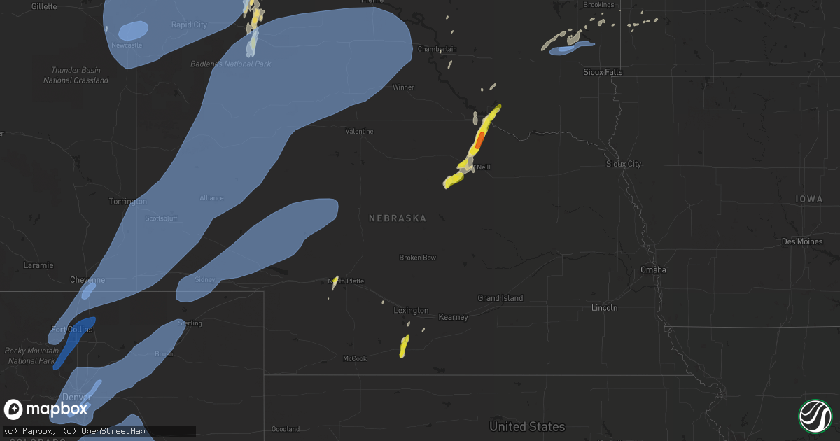
Hail Map in Nebraska on June 6, 2020
Get this storm
June 6 map
$229
one time, instant access
Download today. No call, no setup
Keep the $229
Bought the map and want the full workflow? Apply the entire $229 to a subscription within 7 days. None of it is wasted.
Every map, not just this one
This buys you this map. Subscription and you get every map we run, in the markets you choose from a few cities to whole states to nationwide. Plus real-time alerts the moment a storm fires.
Contact data
Name, contact info, occupancy, even credit band for addresses in the footprint. You go from where it hit to who to call.
Become the source they trust
Unlimited branding weather history reports on demand. You already have the documented answer ready for the property owner, and you are the one who showed up with it.
Property data and RoofTrace estimates
Pull up any address you have got, its value and the exact code rules for that jurisdiction, straight from One Click Code. Then RoofTrace estimates the squares, pitch, and roof value, priced the way you price.
Storm reports in Nebraska
Nebraska
| Date | Description |
|---|---|
| 06/06/20206:58 PM CDT | . |
| 06/06/20206:54 PM CDT | Pivot damage reported in scotts bluff county south of melbeta. |
| 06/06/20206:52 PM CDT | Measured on davis station. |
| 06/06/20206:49 PM CDT | Roof blown off / shingle damage hwy closed. |
| 06/06/20206:47 PM CDT | Davis system. |
| 06/06/20206:47 PM CDT | Window broken out of home. |
| 06/06/20206:46 PM CDT | Scottsbluff airport asos sustained wind 46mph... 70mph wind gust. |
| 06/06/20206:44 PM CDT | Report from mping: 1-inch tree limbs broken; shingles blown off. |
| 06/06/20206:42 PM CDT | Asos station kbff scottsbluff airport - bff. |
| 06/06/20206:35 PM CDT | West of haig. |
| 06/06/20206:15 PM CDT | Awos station kibm kimbal airport - ibm. |
| 06/06/20206:10 PM CDT | Awos station k1bw bravo madis. |
| 06/06/202012:15 PM CDT | A local report indicates 1.75 inch wind near 4 SW BRISTOW |
| 06/06/202012:07 PM CDT | Relayed by media... Time estimated by radar. |
| 06/06/202011:47 AM CDT | Relayed from media... Time estimated by radar. |
| 06/06/20208:52 AM CDT | Quarter size hail covering highway 281 6 miles north of arapahoe. |
| 06/06/20208:45 AM CDT | A local report indicates 1.00 inch wind near 5 N ARAPAHOE |
| 06/06/20207:30 AM CDT | At 1230 PM CDT, a severe thunderstorm was located over Gross, or 7 miles northeast of Spencer, moving northeast at 25 mph. HAZARD...Ping pong ball size hail and 60 mph wind gusts. SOURCE...Radar indicated. IMPACT...People and animals outdoors will be injured. Expect hail damage to roofs, siding, windows, and vehicles. Expect wind damage to roofs, siding, and trees. This severe thunderstorm will be near... Pickstown around 1250 PM CDT. Marty around 1255 PM CDT. Ravinia around 105 PM CDT. Wagner around 110 PM CDT. Dante around 115 PM CDT. |
| 06/06/20206:42 AM CDT | At 1142 AM CDT, a severe thunderstorm was located 14 miles northeast of Atkinson, or 14 miles south of Spencer, moving northeast at 30 mph. HAZARD...Ping pong ball size hail and 60 mph wind gusts. SOURCE...Radar indicated. IMPACT...People and animals outdoors will be injured. Expect hail damage to roofs, siding, windows, and vehicles. Expect wind damage to roofs, siding, and trees. Locations impacted include... Spencer, Lynch, Gross, Bristow, Spencer Dam, Midway and Anncar. This includes the following highways... Highway 281 between mile markers 195 and 216. Highway 12 between mile markers 123 and 142. |
| 06/06/20205:46 AM CDT | At 1046 PM CDT, severe thunderstorms were located along a line extending from Lower Brule to near Hamill to near Wewela, moving northeast at 70 mph. HAZARD...60 mph wind gusts and penny size hail. SOURCE...Radar indicated. IMPACT...Expect damage to roofs, siding, and trees. Severe thunderstorms will be near... Lake Francis Case around 1055 PM CDT. Chamberlain and Dallas around 1100 PM CDT. Gregory and Burke around 1105 PM CDT. Grass Ranch Colony around 1135 PM CDT. Kimball around 1140 PM CDT. White Lake around 1145 PM CDT.Other locations impacted by these severe thunderstorms include DixonIn Gregory County, Fairfax and Pukwana. |
| 06/06/20205:30 AM CDT | At 1029 AM CDT, a severe thunderstorm was located 10 miles north of Amelia, or 16 miles west of O'Neill, moving northeast at 15 mph. HAZARD...60 mph wind gusts and half dollar size hail. SOURCE...Radar indicated. IMPACT...Hail damage to vehicles is expected. Expect wind damage to roofs, siding, and trees. Locations impacted include... O'Neill and Emmet. This includes the following highways... Highway 20 between mile markers 291 and 312. Highway 281 between mile markers 178 and 186. |
| 06/06/20204:29 AM CDT | At 929 AM CDT, a severe thunderstorm was located 10 miles west of Amelia, or 29 miles southeast of Bassett, moving east at 15 mph. HAZARD...60 mph wind gusts and quarter size hail. SOURCE...Radar indicated. IMPACT...Hail damage to vehicles is expected. Expect wind damage to roofs, siding, and trees. Locations impacted include... Chambers, Amelia and Emmet. This includes Highway 20 between mile markers 295 and 302. |
| 06/06/20203:39 AM CDT | At 839 AM CDT, a severe thunderstorm was located near Arapahoe, or 25 miles west of Holdrege, moving north at 30 mph. HAZARD...Quarter size hail. SOURCE...Radar indicated. IMPACT...Damage to vehicles is expected. Locations impacted include... Bertrand, Elwood and Smithfield. |
| 06/06/20202:01 AM CDT | At 700 PM MDT, severe thunderstorms were located along a line extending from 10 miles northwest of Gordon to 20 miles east of Rushville to near Ashby, moving northeast at 55 mph. HAZARD...70 mph wind gusts. SOURCE...Radar indicated. IMPACT...Expect considerable tree damage. Damage is likely to mobile homes, roofs, and outbuildings. Locations impacted include... Gordon, Ellsworth, Merriman, Medicine Lake, Clinton, Speckel Meir Lake, Eli, Big Hill, Dipping Vat Meadow, Billys Lake, Lone Butte, Irwin, Intersection of Highway 61 and Survey Valley Road, Rock Hill, Hoover Lake, Indian Hill, Whitman Road crossing the North Branch of the Middle Loup River, Sevenmile Hill, Watson Lake and Highway 61 crossing the Snake River.This includes the following highways... Highway 20 between mile markers 93 and 158. Highway 2 between mile markers 117 and 129. Highway 61 between mile markers 163 and 230. |
| 06/06/20201:36 AM CDT | At 636 PM MDT, severe thunderstorms were located along a line extending from 4 miles northeast of Sedgwick to near Prewitt Reservoir, or along a line extending from 7 miles south of Chappell to 15 miles southwest of Sterling, moving northeast at 60 mph. HAZARD...70 mph wind gusts. SOURCE...Radar indicated. IMPACT...Expect considerable tree damage. Damage is likely to mobile homes, roofs, and outbuildings. Locations impacted include... Sterling, Holyoke, Julesburg, Haxtun, Fleming, Ovid, Merino, Iliff, Peetz, Sedgwick, Crook, Paoli, Prewitt Reservoir, Padroni, Atwood, Marks Butte, Highland Center, St Petersburg, Proctor and Pleasant Valley. |
| 06/06/20201:26 AM CDT | At 625 AM CDT, two severe thunderstorms were located along a line extending from near Geddes to near Pickstown, moving northeast at 25 mph. HAZARD...Quarter size hail. SOURCE...Radar indicated. IMPACT...Damage to vehicles is expected. Severe thunderstorms will be near... Pickstown around 630 AM CDT. Lake Andes around 635 AM CDT. Marty around 640 AM CDT. Ravinia around 645 AM CDT. Wagner around 700 AM CDT. Armour around 705 AM CDT. Corsica around 710 AM CDT. |
| 06/06/20201:15 AM CDT | At 615 PM MDT, severe thunderstorms were located along a line extending from 8 miles north of Lodgepole to 4 miles northwest of Highland Center to 12 miles south of Otis to 4 miles northwest of Boyero, moving northeast at 55 mph. HAZARD...70 mph wind gusts. SOURCE...Radar indicated. IMPACT...Expect considerable tree damage. Damage is likely to mobile homes, roofs, and outbuildings. Locations impacted include... Yuma, Wray, Stratton, Flagler, Seibert, Eckley and Vona. This includes the following highways... Interstate 70 in Colorado between mile markers 391 and 426. Highway 385 between mile markers 225 and 269. |
| 06/06/202012:58 AM CDT | At 556 PM MDT, severe thunderstorms were located along a line extending from 9 miles northwest of Agate Bed National Monument to near Bayard, moving northeast at 65 mph. HAZARD...70 mph wind gusts. SOURCE...Radar indicated. IMPACT...Expect considerable tree damage. Damage is likely to mobile homes, roofs, and outbuildings. Locations impacted include... Alliance, Chadron, Crawford, Hemingford, Harrison, Alliance Airport, Montrose, Angora, Box Butte Dam, Fort Robinson Campground, Chadron Campground, Berea, Flahertys Corner, Chadron Airport, Wild Horse Butte, Whitney Lake, Box Butte Campground, Red Cloud Campground, Agate Bed National Monument and Kilpatrick Lake. |
| 06/06/202012:57 AM CDT | At 555 PM MDT, severe thunderstorms were located along a line extending from near The Intersection Of Highway 385 And 92 to near Colton to near Crook, moving northeast at 60 mph. HAZARD...70 mph wind gusts. SOURCE...Radar indicated. IMPACT...Expect considerable tree damage. Damage is likely to mobile homes, roofs, and outbuildings. Locations impacted include... Chappell, Oshkosh, Big Springs, Brule, Lewellen, Venango, Lisco, Barton, Crescent Lake National Wildlife Refuge, Dogtown Flats, Deer Lake, Britton Lake, Megeath, Richardson Lake, Miles Lake, Mumper, Mount Vernon, Herman Lake, Adams Flats and Sugar Loaf Hill.This includes the following highways... Highway 2 between mile markers 123 and 130. Highway 92 between mile markers 115 and 126. Interstate 80 in Nebraska between mile markers 78 and 119. |
| 06/06/202012:56 AM CDT | At 552 PM MDT, severe thunderstorms were located along a line extending from Redbank Spring Campground to 5 miles southeast of Jewel Cave National Monument to 7 miles east of Rumford, moving northeast at 70 mph. HAZARD...70 mph wind gusts. SOURCE...Radar indicated. IMPACT...Expect considerable tree damage. Damage is likely to mobile homes, roofs, and outbuildings. Severe thunderstorms will be near... Custer, Deerfield, Crazy Horse Memorial around 600 PM MDT. Oelrichs, Rochford, and Custer State Park around 605 PM MDT. Keystone, Silver City and Smithwick around 610 PM MDT. Nemo and Rockerville around 615 PM MDT. Rapid City, Summerset, Piedmont and Tilford around 620 PM MDT. Rapid Valley and Black Gap around 625 PM MDT. Box Elder and Rapid City Airport around 630 PM MDT. New Underwood around 640 PM MDT.This includes Interstate 90 in South Dakota between Mile Markers 34and 92. |
| 06/06/202012:42 AM CDT | At 541 PM MDT, severe thunderstorms were located along a line extending from 6 miles south of Morrisey to 19 miles southeast of Redbird to 9 miles southeast of Prairie Center, moving northeast at 65 mph. HAZARD...70 mph wind gusts. SOURCE...Radar indicated. IMPACT...Expect considerable tree damage. Damage is likely to mobile homes, roofs, and outbuildings. Locations impacted include... Lingle, Harrison, Prairie Center, Jay Em, Mule Creek Junction, Agate Bed National Monument, Montrose, Redbird, Van Tassell and Hwy 85 At Dry Rawhide Creek. |
| 06/06/202012:28 AM CDT | At 528 PM MDT, severe thunderstorms were located along a line extending from near Kimball to near Westplains, moving northeast at 65 mph. HAZARD...70 mph wind gusts. SOURCE...Radar indicated. IMPACT...Expect considerable tree damage. Damage is likely to mobile homes, roofs, and outbuildings. Locations impacted include... Sidney, Bridgeport, Potter, Lodgepole, Dalton, Dix, Gurley, Sunol, Brownson, Northport, Bridgeport State Recreation Area, Colton, Lorenzo, The Intersection Of Highway 385 And 92, Court House And Jail Rocks, Sidney Airport, Redington and Broadwater.This includes Interstate 80 in Nebraska between mile markers 24 and77. |
| 06/06/202012:14 AM CDT | At 512 PM MDT, severe thunderstorms were located along a line extending from 14 miles north of Lance Creek to near Lusk to near Fort Laramie, moving northeast at 85 mph. HAZARD...70 mph wind gusts. SOURCE...Radar indicated. IMPACT...Expect considerable tree damage. Damage is likely to mobile homes, roofs, and outbuildings. Locations impacted include... Lingle, Harrison, Prairie Center, Jay Em, Mule Creek Junction, Agate Bed National Monument, Montrose, Redbird, Van Tassell and Hwy 85 At Dry Rawhide Creek. |
| 06/05/202010:07 PM CDT | At 307 PM CDT, a severe thunderstorm was located near North Platte, moving northeast at 45 mph. HAZARD...60 mph wind gusts and quarter size hail. SOURCE...Radar indicated. IMPACT...Hail damage to vehicles is expected. Expect wind damage to roofs, siding, and trees. Locations impacted include... North Platte, Stapleton, Hershey, Gandy, Ringgold and Birdwood. This includes the following highways... Highway 92 between mile markers 208 and 236. Highway 97 between mile markers 1 and 26. Interstate 80 in Nebraska between mile markers 165 and 175. Highway 83 between mile markers 84 and 113. |
| 06/05/20209:59 PM CDT | A local report indicates 70 MPH wind near VALENTINE |
| 06/05/20209:50 PM CDT | Asos station kvtn valentine airport. |
| 06/05/20208:30 PM CDT | Mesonet station up252 8.1 w lodgepole |
| 06/05/20208:22 PM CDT | Kings canyon mesonet site wind gust of 68mph at chadron state park. |
| 06/05/20208:20 PM CDT | Public report of minor structure blow overs due to estimated wind gust of 60mph at road 8/road 19. |
| 06/05/20208:18 PM CDT | A local report indicates 65 MPH wind near 14 SW ARTHUR |
| 06/05/20208:15 PM CDT | Power pole snapped along highway 20 at mm 117. Report with photo via social media. Time estimated from radar. |
| 06/05/20208:15 PM CDT | Sidney airport wind gust of 60mph. |
| 06/05/20208:10 PM CDT | A local report indicates 61 MPH wind near GORDON |
| 06/05/20208:05 PM CDT | A local report indicates 60 MPH wind near GORDON |
| 06/05/20208:03 PM CDT | A local report indicates 69 MPH wind near 4 SE GORDON |
| 06/05/20207:49 PM CDT | Chadron... Chadron municipal airport. |
| 06/05/20207:40 PM CDT | A local report indicates 63 MPH wind near CRESCENT LAKE NWR |
| 06/05/20207:37 PM CDT | 8 inch in diameter branches down. Time estimated from radar. |
| 06/05/20207:30 PM CDT | Tree blew over and came through the roof of a house in scottsbluff. No injuries reported. |
| 06/05/20207:30 PM CDT | Multiple trees uprooted at bridgeport cemetery |
| 06/05/20207:29 PM CDT | Several small outbuildings blown over in melbeta area. Metal roofs stripped off. Large trees blown over. Several pivots flipped over. |
| 06/05/20207:25 PM CDT | Wind gusts of at least 60 mph |
| 06/05/20207:24 PM CDT | A local report indicates 65 MPH wind near 17 NNE HARRISON |
| 06/05/20207:21 PM CDT | Raws agtn1. |
| 06/05/20207:21 PM CDT | Asos station kaia alliance airport. |
| 06/05/20207:20 PM CDT | Entire tree |
| 06/05/20207:16 PM CDT | Measured on davis station. |
| 06/05/20207:14 PM CDT | Corrects previous tstm wnd dmg report from mitchell. Tin... Detached from a building... Blew into and hit a motorcycle with two passengers on it while they were riding |
| 06/05/20207:07 PM CDT | Corrects time from previous tstm wnd dmg report from melbeta. Several small outbuildings blown over in melbeta area. Metal roofs stripped off. Large trees blown over. S |
| 06/05/20207:07 PM CDT | Reports of 3 to 4 miles of power poles broken off 1 mile west of mcgrew. |
| 06/05/20207:07 PM CDT | Bayard and rural areas surrounding bayard reporting power outages. |
| 06/05/20207:07 PM CDT | Corrects time from previous tstm wnd dmg report from scottsbluff. Tree blew over and came through the roof of a house in scottsbluff. No injuries reported. |
| 06/05/20207:06 PM CDT | Roof blown off a building. |
| 06/05/20207:05 PM CDT | Sidney airport asos reports 33mph sustained wind... Gust of 64mph. |
| 06/05/20207:05 PM CDT | Corrects previous tstm wnd dmg report from 1 nnw scottsbluff. Railway cross beam broken reported at ave b... Scottsbluff. |
| 06/05/20207:04 PM CDT | Huge tree west of cr27 reported at lake minatare road. |
| 06/05/20207:04 PM CDT | Nppd reports 3...361 customers without power in scottsbluff area. |
| 06/05/20207:00 PM CDT | Asos station kbff scottsbluff airport - bff. |
All States Impacted by Hail Map on June 6, 2020
Cities Impacted by Hail Map on June 6, 2020
- Flandreau, SD
- Colman, SD
- Rye, CO
- Faith, SD
- Canterbury, CT
- Windham, CT
- Baltic, CT
- Jewett City, CT
- Atkinson, NE
- Stuart, NE
- Denmark, ME
- Fryeburg, ME
- Left Hand, WV
- Clendenin, WV
- Amma, WV
- Millville, MA
- Uxbridge, MA
- Backus, MN
- Pine River, MN
- Cahone, CO
- Blanding, UT
- Lake Powell, UT
- Armour, SD
- Corsica, SD
- Louisa, KY
- Dolores, CO
- Jordan, MN
- Vernal, UT
- Thompson, UT
- Patriot, OH
- Gallipolis, OH
- Wolford, ND
- Port Haywood, VA
- Susan, VA
- Becker, MN
- Princeton, MN
- Flasher, ND
- Auburn, MA
- Worcester, MA
- North Grafton, MA
- Millbury, MA
- Bowling Green, VA
- Woodford, VA
- Tappahannock, VA
- Newtown, VA
- Fredericksburg, VA
- Walkerton, VA
- Bruington, VA
- Aylett, VA
- Saint Stephens Church, VA
- Milford, VA
- Port Royal, VA
- Ruther Glen, VA
- Dupree, SD
- Bristow, NE
- Oneill, NE
- Spencer, NE
- Harts, WV
- Chapmanville, WV
- Edison, NE
- Elwood, NE
- Arapahoe, NE
- Goodrich, ND
- Cobbs Creek, VA
- Gloucester, VA
- North, VA
- Dutton, VA
- Hartfield, VA
- Marlborough, CT
- Lake George, CO
- Grayson, KY
- Webbville, KY
- Hitchins, KY
- Wall, SD
- Mekinock, ND
- Quinn, SD
- Howes, SD
- Wasta, SD
- Scenic, SD
- Little Falls, MN
- Escalante, UT
- Sauk Rapids, MN
- Cayuga, ND
- Lidgerwood, ND
- Warwick, ND
- New Rockford, ND
- Upton, MA
- Cortez, CO
- Bowlus, MN
- Holdingford, MN
- Hensel, ND
- Cavalier, ND
- Clewiston, FL
- Holden, WV
- Logan, WV
- Dunlow, WV
- Genoa, WV
- Monticello, UT
- Denhoff, ND
- Bemidji, MN
- Looneyville, WV
- Newton, WV
- Plummer, MN
- Minot, ND
- Northwood, ND
- West Brookfield, MA
- North Brookfield, MA
- Warren, MA
- Ireland, WV
- Reeder, ND
- Royalton, MN
- Rice, MN
- Saint Joseph, MN
- Avon, MN
- Glenwood, WV
- Crown City, OH
- Fairfax, SD
- Lynch, NE
- Poland, ME
- Naples, ME
- New Gloucester, ME
- Casco, ME
- Raymond, ME
- Verndale, MN
- Staples, MN
- Hazen, ND
- Hesperus, CO
- Las Vegas, NM
- Tinnie, NM
- Capitan, NM
- Upton, WY
- Mott, ND
- Culloden, WV
- Ranger, WV
- Mud Butte, SD
- Veblen, SD
- Medfield, MA
- Walpole, MA
- Dover, MA
- Griffithsville, WV
- Hamlin, WV
- Yawkey, WV
- Hurricane, WV
- Sod, WV
- Deep River, CT
- Killingworth, CT
- Bertrand, NE
- Spencer, WV
- Melfa, VA
- Wagner, SD
- Lake Andes, SD
- Pueblo, CO
- Hebron, ND
- Rush City, MN
- Grantsburg, WI
- Almont, ND
- Foley, MN
- Mathews, VA
- Cardinal, VA
- Bohannon, VA
- Foster, VA
- Boswell, OK
- Rock Cave, WV
- Lenore, WV
- Breeden, WV
- Wilsondale, WV
- Kermit, WV
- Union Center, SD
- Selden, KS
- Warsaw, VA
- Mcville, ND
- Isle, MN
- Aitkin, MN
- Carson, ND
- Ellamore, WV
- Coalton, WV
- Labelle, FL
- Pagosa Springs, CO
- Voltaire, ND
- Cherry Creek, SD
- Cohagen, MT
- Terry, MT
- Branchland, WV
- Salt Rock, WV
- Barboursville, WV
- Bolton, MA
- Stow, MA
- Sudbury, MA
- Hudson, MA
- Maddock, ND
- Bigfork, MN
- Milton, WV
- Rosebud, MT
- Hathaway, MT
- Bethel, MN
- Stacy, MN
- Isanti, MN
- Oakes, ND
- North Platte, NE
- Garrison, ND
- Ryder, ND
- Berwick, ME
- North Berwick, ME
- Ogunquit, ME
- Wells, ME
- South Berwick, ME
- Holland, MN
- Big Bend, WV
- Grace City, ND
- Meadow, SD
- Jericho, NY
- Elkton, SD
- Circle, MT
- Sartell, MN
- Ocate, NM
- North Franklin, CT
- South Windham, CT
- Alkol, WV
- Danville, WV
- Julian, WV
- Gettysburg, SD
- Geddes, SD
- Motley, MN
- Pine City, MN
- Deer River, MN
- Spring Lake, MN
- Max, MN
- Douglas, ND
- Kinsey, MT
- Wyndmere, ND
- Belle Plaine, MN
- Carver, MN
- Pipestone, MN
- Center, CO
- Moffat, CO
- Balaton, MN
- Ruthton, MN
- Cumberland, RI
- Esmond, ND
- Mcclusky, ND
- Zap, ND
- Valmora, NM
- Watrous, NM
- Emerado, ND
- Bridgton, ME
- Argyle, MN
- Alvarado, MN
- Oslo, MN
- Manvel, ND
- Grand Forks Afb, ND
- Webster Springs, WV
- Cowen, WV
- Shakopee, MN
- Sanbornville, NH
- Shapleigh, ME
- Acton, ME
- Winfred, SD
- Sutton, MA
- Charlton, MA
- Rochdale, MA
- Oxford, MA
- North Oxford, MA
- Tyler, MN
- Gilby, ND
- Minto, ND
- Harrisville, RI
- North Smithfield, RI
- Douglas, MA
- Nisland, SD
- Vale, SD
- Whitewood, SD
- Newell, SD
- Sawyer, OK
- Park Rapids, MN
- Ona, WV
- Alamo, ND
- Slatersville, RI
- Leicester, MA
- Blackstone, MA
- Wrentham, MA
- Franklin, MA
- Brookfield, MA
- Spencer, MA
- Whitinsville, MA
- Bellingham, MA
- Mendon, MA
- East Brookfield, MA
- Woonsocket, RI
- Forestdale, RI
- Rugby, ND
- Madison, SD
- Topping, VA
- Saluda, VA
- Locust Hill, VA
- Hershey, NE
- Brookings, SD
- Nevis, MN
- Sutton, WV
- Prichard, WV
- Menahga, MN
- Atoka, OK
- Snowville, UT
- West Hamlin, WV
- Max, ND
- Harvey, ND
- East Wakefield, NH
- Wolfeboro, NH
- Aurora, ME
- Ellsworth, ME
- Butte, NE
- Mapleton, ND
- Gann Valley, SD
- Hettinger, ND
- Arthur City, TX
- Walker, MN
- Powderly, TX
- Beulah, ND
- Walton, WV
- Hayes, VA
- Sauk Centre, MN
- Osakis, MN
- West Union, MN
- Dingess, WV
- Hackensack, MN
- Forest River, ND
- Deltaville, VA
- Norcross, MN
- Lemmon, SD
- Wentworth, SD
- Rutland, SD
- Mcgregor, ND
- Heathsville, VA
- Kilmarnock, VA
- Lignite, ND
- Portal, ND
- Elbow Lake, MN
- Columbus, ND
- Crosby, ND
- Saint Francis, MN
- Cedar, MN
- Wagon Mound, NM
- Ashton, WV
- Apple Grove, WV
- Emmet, NE
- Amelia, NE
- Granville, ND
- Towner, ND
- Ray, ND
- Tioga, ND
- Wallace, NE
- Duck, WV
- Clay, WV
- Carrington, ND
- Oak Park, MN
- Onancock, VA
- Shacklefords, VA
- West Point, VA
- Mattaponi, VA
- Chamberlain, SD
- Pilgrim, KY
- Inez, KY
- Leonard, ND
- Kindred, ND
- Volga, SD
- Nunda, SD
- Park Valley, UT
- Gothenburg, NE
- Cozad, NE
- Spencer, SD
- Howard, SD
- Alexandria, SD
- Canova, SD
- Le Roy, WV
- Reedy, WV
- Centerbrook, CT
- Ivoryton, CT
- Essex, CT
- Underwood, ND
- Plainfield, CT
- Moosup, CT
- King William, VA
- Spotsylvania, VA
- Stevensville, VA
- Montross, VA
- Colonial Beach, VA
- Tornado, WV
- Albany, MN
- Pukwana, SD
- Platte, SD
- Manquin, VA
- Proctorville, OH
- Chesapeake, OH
- Wayne, WV
- Fort Gay, WV
- Lancaster, VA
- Farnham, VA
- Sanbornton, NH
- Enning, SD
- White Owl, SD
- Ross, ND
- Stanley, ND
- Trail, MN
- Vanceburg, KY
- Garrison, KY
- Stout, OH
- Blue Creek, OH
- Turtle Creek, WV
- Hewett, WV
- Wallback, WV
- Procious, WV
- Hudgins, VA
- Hallieford, VA
- Diggs, VA
- Moon, VA
- Wake, VA
- Onemo, VA
- Larimore, ND
- New Prague, MN
- Orma, WV
- Powers Lake, ND
- Tilton, NH
- Franklin, NH
- White Stone, VA
- Irvington, VA
- Weems, VA
- Aneta, ND
- New Kent, VA
- Mechanicsville, VA
- Arvilla, ND
- Richardton, ND
- Edmore, ND
- Fairdale, ND
- Ruso, ND
- Monte Vista, CO
- Maynard, MA
- Marlborough, MA
- Crum, WV
- Omar, WV
- Switzer, WV
- Eureka, SD
- Elko New Market, MN
- Prior Lake, MN
- Wellesley, MA
- Natick, MA
- Weston, MA
- Wayland, MA
- Wellesley Hills, MA
- Keldron, SD
- Hurdsfield, ND
- Glen Ullin, ND
- Clear Lake, MN
- Belle Fourche, SD
- Cambridge, MN
- Huntington, WV
- Pickens, WV
- Yorktown, VA
- Sterling, MA
- Clinton, MA
- Lancaster, MA
- Fairmount, ND
- Cologne, MN
- Chaska, MN
- Langford, SD
- Pierpont, SD
- Karlsruhe, ND
- Bagley, MN
- Bottineau, ND
- North Branch, MN
- Attleboro, MA
- Mansfield, MA
- North Attleboro, MA
- Northbridge, MA
- Sturbridge, MA
- Fiskdale, MA
- Norton, MA
- Attleboro Falls, MA
- Plainville, MA
- Brimfield, MA
- Canton, MA
- Dedham, MA
- Westwood, MA
- Norwood, MA
- Milton, MA
- Randolph, MA
- Quincy, MA
- Alfred, ME
- Waterboro, ME
- Bluff, UT
- Orlando, FL
- Longwood, FL
- Altamonte Springs, FL
- Winter Park, FL
- Deltona, FL
- Ormond Beach, FL
- Lake Mary, FL
- Winter Springs, FL
- Casselberry, FL
- Deland, FL
- Maitland, FL
- Daytona Beach, FL
- Sanford, FL
- Lake Helen, FL
- Debary, FL
- Orange City, FL
- De Leon Springs, FL
- Palm Coast, FL
- Bunnell, FL
- Apopka, FL
- Ocoee, FL
- Clearwater, FL
- Louviers, CO
- Dupont, CO
- Arvada, CO
- Bailey, CO
- Morrison, CO
- Sterling, CO
- Evergreen, CO
- Log Lane Village, CO
- Brush, CO
- Louisville, CO
- Bennett, CO
- Weldona, CO
- Conifer, CO
- Frederick, CO
- Fort Morgan, CO
- Akron, CO
- Roggen, CO
- Westminster, CO
- Littleton, CO
- Byers, CO
- Sedalia, CO
- Lone Tree, CO
- Watkins, CO
- Hillrose, CO
- Englewood, CO
- Lafayette, CO
- Indian Hills, CO
- Kittredge, CO
- Henderson, CO
- Pine, CO
- Strasburg, CO
- Commerce City, CO
- Golden, CO
- Brighton, CO
- Erie, CO
- Keenesburg, CO
- Snyder, CO
- Orchard, CO
- Aurora, CO
- Atwood, CO
- Thornton, CO
- Castle Rock, CO
- Merino, CO
- Broomfield, CO
- Parker, CO
- Idledale, CO
- Denver, CO
- Stoneham, CO
- Wheat Ridge, CO
- Wiggins, CO
- Fort Lupton, CO
- Hudson, CO
- Buffalo Creek, CO
- Dacono, CO
- Meriden, WY
- Batesland, SD
- Carpenter, WY
- Wounded Knee, SD
- Long Valley, SD
- Mcgrew, NE
- Chadron, NE
- Presho, SD
- Hemingford, NE
- Lower Brule, SD
- Kyle, SD
- Potter, NE
- Vivian, SD
- Okreek, SD
- Bushnell, NE
- Mitchell, NE
- Draper, SD
- Angora, NE
- Yoder, WY
- Saint Francis, SD
- Reliance, SD
- Bayard, NE
- Parmelee, SD
- Melbeta, NE
- Scottsbluff, NE
- Belvidere, SD
- Pine Bluffs, WY
- Okaton, SD
- Hay Springs, NE
- Oglala, SD
- Lakeside, NE
- White River, SD
- Kennebec, SD
- Rushville, NE
- Albin, WY
- Murdo, SD
- Alliance, NE
- Hawk Springs, WY
- Midland, SD
- Gordon, NE
- Wanblee, SD
- Winner, SD
- Hamill, SD
- Wood, SD
- Ellsworth, NE
- Bridgeport, NE
- Dix, NE
- Glen Haven, CO
- Minatare, NE
- Wellington, CO
- Rosebud, SD
- Hereford, CO
- Cody, NE
- Bellvue, CO
- Harrison, NE
- Nunn, CO
- Merriman, NE
- Martin, SD
- Marsland, NE
- Crawford, NE
- Gering, NE
- Kadoka, SD
- Fort Collins, CO
- Lagrange, WY
- Caputa, SD
- Manderson, SD
- Bingham, NE
- Mission, SD
- Morrill, NE
- Ault, CO
- Burns, WY
- Carr, CO
- Lyman, NE
- Ideal, SD
- Tuthill, SD
- Ashby, NE
- Interior, SD
- Allen, SD
- Whitney, NE
- Philip, SD
- Oelrichs, SD
- Grover, CO
- Drake, CO
- Witten, SD
- Torrington, WY
- Loveland, CO
- Fort Pierre, SD
- Harrisburg, NE
- Cheyenne, WY
- Hillsdale, WY
- Norris, SD
- Kimball, NE
- Laporte, CO
- Pine Ridge, SD
- Porcupine, SD
- Ward, CO
- Johnstown, CO
- Windsor, CO
- Berthoud, CO
- Lyons, CO
- Timnath, CO
- Boulder, CO
- Eaton, CO
- Longmont, CO
- Jamestown, CO
- Pierce, CO
- Severance, CO
- Elizabeth, CO
- Agate, CO
- Matheson, CO
- Divide, CO
- Franktown, CO
- Peyton, CO
- Usaf Academy, CO
- Palmer Lake, CO
- Elbert, CO
- Ramah, CO
- Rush, CO
- Cripple Creek, CO
- Colorado Springs, CO
- Kiowa, CO
- Simla, CO
- Larkspur, CO
- Green Mountain Falls, CO
- Yoder, CO
- Victor, CO
- Manitou Springs, CO
- Penrose, CO
- Woodland Park, CO
- Florissant, CO
- Deer Trail, CO
- Cascade, CO
- Fountain, CO
- Calhan, CO
- Monument, CO
- Limon, CO
- Canon City, CO
- Guffey, CO
- Hugo, CO
- Boone, CO
- Avondale, CO
- Chappell, NE
- Dalton, NE
- Oshkosh, NE
- Mullen, NE
- Whitman, NE
- Tryon, NE
- Hyannis, NE
- Lodgepole, NE
- Gurley, NE
- Sidney, NE
- Arthur, NE
- Lewellen, NE
- Padroni, CO
- Lemoyne, NE
- Lisco, NE
- Peetz, CO
- Broadwater, NE
- Alzada, MT
- Raleigh, ND
- Newcastle, WY
- Prairie City, SD
- Amidon, ND
- Deadwood, SD
- Black Hawk, SD
- Hill City, SD
- Aladdin, WY
- Hulett, WY
- Fort Meade, SD
- Osage, WY
- Marmarth, ND
- Selfridge, ND
- Hermosa, SD
- Bison, SD
- Ekalaka, MT
- New England, ND
- McLaughlin, SD
- Edgemont, SD
- Alva, WY
- Ralph, SD
- Elgin, ND
- McIntosh, SD
- Nemo, SD
- Sturgis, SD
- Rapid City, SD
- Saint Onge, SD
- Isabel, SD
- Regent, ND
- Spearfish, SD
- Scranton, ND
- Watauga, SD
- Beulah, WY
- Owanka, SD
- Ludlow, SD
- Ellsworth Afb, SD
- Sundance, WY
- Piedmont, SD
- Eagle Butte, SD
- Timber Lake, SD
- New Underwood, SD
- Morristown, SD
- Moorcroft, WY
- Lead, SD
- New Leipzig, ND
- Capitol, MT
- Lodgepole, SD
- Box Elder, SD
- Bowman, ND
- Buffalo, SD
- Rhame, ND
- Custer, SD
- Camp Crook, SD
- Keystone, SD
- Reva, SD
- Dell Rapids, SD
- Colton, SD
- Salem, SD
- Montrose, SD
- Chester, SD


