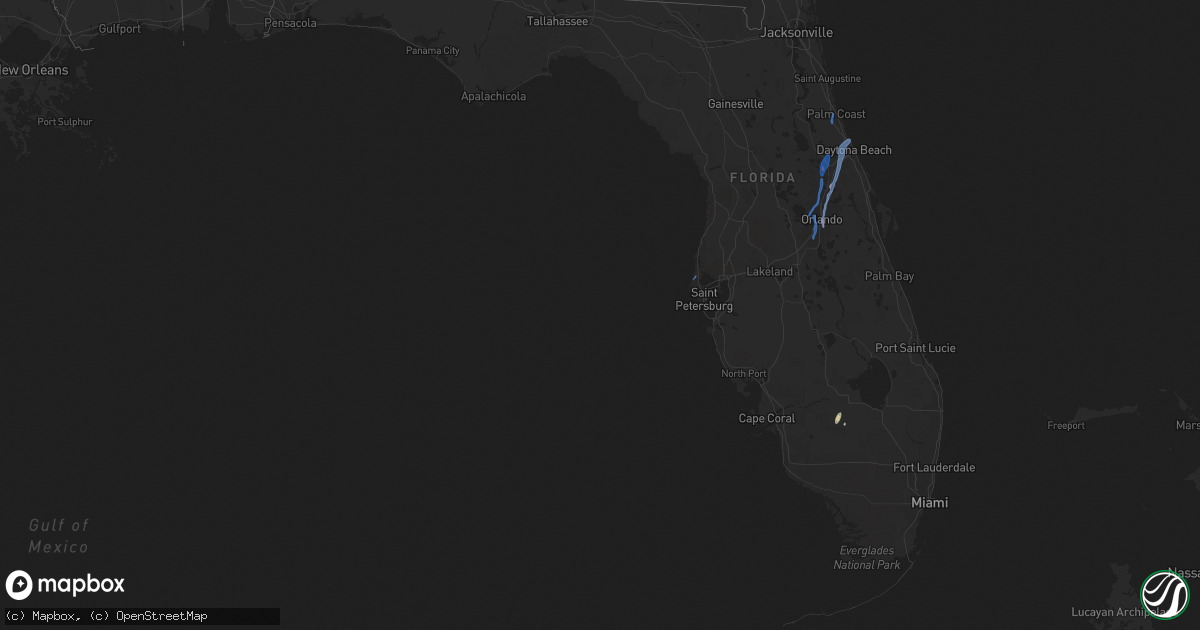
Hail Map in Florida on June 6, 2020
Get this storm
June 6 map
$229
one time, instant access
Download today. No call, no setup
Keep the $229
Bought the map and want the full workflow? Apply the entire $229 to a subscription within 7 days. None of it is wasted.
Every map, not just this one
This buys you this map. Subscription and you get every map we run, in the markets you choose from a few cities to whole states to nationwide. Plus real-time alerts the moment a storm fires.
Contact data
Name, contact info, occupancy, even credit band for addresses in the footprint. You go from where it hit to who to call.
Become the source they trust
Unlimited branding weather history reports on demand. You already have the documented answer ready for the property owner, and you are the one who showed up with it.
Property data and RoofTrace estimates
Pull up any address you have got, its value and the exact code rules for that jurisdiction, straight from One Click Code. Then RoofTrace estimates the squares, pitch, and roof value, priced the way you price.
Storm reports in Florida
Florida
| Date | Description |
|---|---|
| 06/06/20206:59 PM CDT | Social media picture of trees on vehicles on long street near ridge avenue. More trees downed near gentry street and ridge avenue. Also damage near north keene road and |
| 06/06/20206:32 PM CDT | Orlando fire rescue on scene reported multiple trees and power lines down stretching from lake margaret dr to fern creek ave. Possible tornado. |
| 06/06/20206:32 PM CDT | Reports of tree damage in thornton park. Possible tornado. Time estimated from radar. |
| 06/06/20206:30 PM CDT | A tornado was observed via a live camera from a tv news channel crossing the 408 between the orlando executive airport and downtown orlando with power flashes. The torn |
| 06/06/20206:26 PM CDT | Several trees were reported down on homes in east orlando... On harding road... Briecliff... And catherine streets. Additional damage was reported on lake margaret driv |
| 06/06/20206:18 PM CDT | Video received from the public showing a waterspout over lake conway. |
| 06/06/20205:30 PM CDT | A member of the public reports a large tree limb down at the intersection of bear lake road and holliday road in forest city. |
| 06/06/20205:20 PM CDT | One barn damaged and home with roof damage at cr466 and cr227. |
| 06/06/20205:07 PM CDT | Multiple videos received via social media of a landspout tornado touching down in the area of i4 and the mall at millenia. Time and location estimated from radar and vi |
| 06/06/20204:57 PM CDT | Tree reported down at 1609 long street in clearwater. |
| 06/06/20204:53 PM CDT | Trained spotter reported a quick tornado touch down on highway 50 picking up dirt. No damage was reported. |
| 06/06/20203:15 PM CDT | Trees and power lines were damaged by thunderstorm winds from belleview to summerfield along se 95th court... Nw 20th ave... 92th loop and se 126th place. |
| 06/06/20204:16 AM CDT | At 916 PM EDT, a severe thunderstorm was located near Bunnell, moving north at 20 mph. HAZARD...60 mph wind gusts. SOURCE...Radar indicated. IMPACT...Expect damage to roofs, siding, and trees. Locations impacted include... Palm Coast, Bunnell, Hastings, Saint Augustine Shores, Spuds, Espanola and Dupont Center. |
| 06/06/20204:04 AM CDT | At 904 PM EDT, a severe thunderstorm was located near Crescent Beach, or 11 miles south of Saint Augustine, moving northwest at 35 mph. HAZARD...60 mph wind gusts. SOURCE...Radar indicated. IMPACT...Expect damage to roofs, siding, and trees. Locations impacted include... Saint Augustine, World Golf Village, Saint Augustine Beach, Marineland, Vilano Beach, South Ponte Vedra, Crescent Beach, Saint Augustine Shores, Butler Beach and Saint Augustine South. |
| 06/06/20203:45 AM CDT | At 844 PM EDT, a severe thunderstorm was located over Lake Helen, moving north at 25 mph. HAZARD...60 mph wind gusts. SOURCE...Radar indicated. IMPACT...Expect damage to roofs, siding, and trees. Locations impacted include... Deltona, Daytona Beach, DeLand, Holly Hill and Orange City. |
| 06/06/20201:57 AM CDT | At 657 PM EDT, a severe thunderstorm was located 7 miles southwest of Salt Springs, moving north at 15 mph. HAZARD...60 mph wind gusts. SOURCE...Radar indicated. IMPACT...Expect damage to roofs, siding, and trees. Locations impacted include... Salt Springs, Lake Delancy, Welaka and Hog Valley. |
| 06/05/202010:29 PM CDT | At 329 PM EDT, a severe thunderstorm was located near Lake Weir, or near The Villages, moving north at 15 mph. HAZARD...60 mph wind gusts. SOURCE...Radar indicated. IMPACT...Expect damage to roofs, siding, and trees. Locations impacted include... Ocala, Santos, Ocklawaha, Silver Springs Shores, Lake Weir, Belleview and Summerfield. |
| 06/05/202010:12 PM CDT | At 311 PM EDT, a severe thunderstorm was located near Devils Garden, or 9 miles southwest of Montura, moving north at 20 mph. HAZARD...60 mph wind gusts. SOURCE...Radar indicated. IMPACT...Expect damage to roofs, siding, and trees. Locations impacted include... Ortona. |
| 06/05/20209:57 PM CDT | At 257 PM EDT, a severe thunderstorm was located near Wildwood, moving north at 25 mph. HAZARD...60 mph wind gusts. SOURCE...Radar indicated. IMPACT...Expect damage to roofs, siding, and trees. Locations impacted include... Wildwood, Lake Panasoffkee, Coleman, Adamsville, Oxford and Rutland. |
| 06/05/20209:46 PM CDT | At 245 PM EDT, a severe thunderstorm was located over Devils Garden, or near Montura, moving north at 20 mph. HAZARD...60 mph wind gusts and penny size hail. SOURCE...Radar indicated. IMPACT...Expect damage to roofs, siding, and trees. Locations impacted include... Moore Haven, Montura, Devils Garden and Lake Hicpochee. |
| 06/05/20209:01 PM CDT | /corrected date/ i-95 closed at mile marker 261... 2 miles sw of the airport... Due to debris in the road. Siding and roof damage reported to some structures on mary mc |
| 06/05/20207:32 PM CDT | Public reported trees downed and and strong winds estimated at 60-70mph in four corners. Possible tornado. |
| 06/05/20207:30 PM CDT | The public witnessed a tornado on the north shore of lake monroe as it moved onshore and quickly dissipated. Time estimated from radar. |
All States Impacted by Hail Map on June 6, 2020
Cities Impacted by Hail Map on June 6, 2020
- Flandreau, SD
- Colman, SD
- Rye, CO
- Faith, SD
- Canterbury, CT
- Windham, CT
- Baltic, CT
- Jewett City, CT
- Atkinson, NE
- Stuart, NE
- Denmark, ME
- Fryeburg, ME
- Left Hand, WV
- Clendenin, WV
- Amma, WV
- Millville, MA
- Uxbridge, MA
- Backus, MN
- Pine River, MN
- Cahone, CO
- Blanding, UT
- Lake Powell, UT
- Armour, SD
- Corsica, SD
- Louisa, KY
- Dolores, CO
- Jordan, MN
- Vernal, UT
- Thompson, UT
- Patriot, OH
- Gallipolis, OH
- Wolford, ND
- Port Haywood, VA
- Susan, VA
- Becker, MN
- Princeton, MN
- Flasher, ND
- Auburn, MA
- Worcester, MA
- North Grafton, MA
- Millbury, MA
- Bowling Green, VA
- Woodford, VA
- Tappahannock, VA
- Newtown, VA
- Fredericksburg, VA
- Walkerton, VA
- Bruington, VA
- Aylett, VA
- Saint Stephens Church, VA
- Milford, VA
- Port Royal, VA
- Ruther Glen, VA
- Dupree, SD
- Bristow, NE
- Oneill, NE
- Spencer, NE
- Harts, WV
- Chapmanville, WV
- Edison, NE
- Elwood, NE
- Arapahoe, NE
- Goodrich, ND
- Cobbs Creek, VA
- Gloucester, VA
- North, VA
- Dutton, VA
- Hartfield, VA
- Marlborough, CT
- Lake George, CO
- Grayson, KY
- Webbville, KY
- Hitchins, KY
- Wall, SD
- Mekinock, ND
- Quinn, SD
- Howes, SD
- Wasta, SD
- Scenic, SD
- Little Falls, MN
- Escalante, UT
- Sauk Rapids, MN
- Cayuga, ND
- Lidgerwood, ND
- Warwick, ND
- New Rockford, ND
- Upton, MA
- Cortez, CO
- Bowlus, MN
- Holdingford, MN
- Hensel, ND
- Cavalier, ND
- Clewiston, FL
- Holden, WV
- Logan, WV
- Dunlow, WV
- Genoa, WV
- Monticello, UT
- Denhoff, ND
- Bemidji, MN
- Looneyville, WV
- Newton, WV
- Plummer, MN
- Minot, ND
- Northwood, ND
- West Brookfield, MA
- North Brookfield, MA
- Warren, MA
- Ireland, WV
- Reeder, ND
- Royalton, MN
- Rice, MN
- Saint Joseph, MN
- Avon, MN
- Glenwood, WV
- Crown City, OH
- Fairfax, SD
- Lynch, NE
- Poland, ME
- Naples, ME
- New Gloucester, ME
- Casco, ME
- Raymond, ME
- Verndale, MN
- Staples, MN
- Hazen, ND
- Hesperus, CO
- Las Vegas, NM
- Tinnie, NM
- Capitan, NM
- Upton, WY
- Mott, ND
- Culloden, WV
- Ranger, WV
- Mud Butte, SD
- Veblen, SD
- Medfield, MA
- Walpole, MA
- Dover, MA
- Griffithsville, WV
- Hamlin, WV
- Yawkey, WV
- Hurricane, WV
- Sod, WV
- Deep River, CT
- Killingworth, CT
- Bertrand, NE
- Spencer, WV
- Melfa, VA
- Wagner, SD
- Lake Andes, SD
- Pueblo, CO
- Hebron, ND
- Rush City, MN
- Grantsburg, WI
- Almont, ND
- Foley, MN
- Mathews, VA
- Cardinal, VA
- Bohannon, VA
- Foster, VA
- Boswell, OK
- Rock Cave, WV
- Lenore, WV
- Breeden, WV
- Wilsondale, WV
- Kermit, WV
- Union Center, SD
- Selden, KS
- Warsaw, VA
- Mcville, ND
- Isle, MN
- Aitkin, MN
- Carson, ND
- Ellamore, WV
- Coalton, WV
- Labelle, FL
- Pagosa Springs, CO
- Voltaire, ND
- Cherry Creek, SD
- Cohagen, MT
- Terry, MT
- Branchland, WV
- Salt Rock, WV
- Barboursville, WV
- Bolton, MA
- Stow, MA
- Sudbury, MA
- Hudson, MA
- Maddock, ND
- Bigfork, MN
- Milton, WV
- Rosebud, MT
- Hathaway, MT
- Bethel, MN
- Stacy, MN
- Isanti, MN
- Oakes, ND
- North Platte, NE
- Garrison, ND
- Ryder, ND
- Berwick, ME
- North Berwick, ME
- Ogunquit, ME
- Wells, ME
- South Berwick, ME
- Holland, MN
- Big Bend, WV
- Grace City, ND
- Meadow, SD
- Jericho, NY
- Elkton, SD
- Circle, MT
- Sartell, MN
- Ocate, NM
- North Franklin, CT
- South Windham, CT
- Alkol, WV
- Danville, WV
- Julian, WV
- Gettysburg, SD
- Geddes, SD
- Motley, MN
- Pine City, MN
- Deer River, MN
- Spring Lake, MN
- Max, MN
- Douglas, ND
- Kinsey, MT
- Wyndmere, ND
- Belle Plaine, MN
- Carver, MN
- Pipestone, MN
- Center, CO
- Moffat, CO
- Balaton, MN
- Ruthton, MN
- Cumberland, RI
- Esmond, ND
- Mcclusky, ND
- Zap, ND
- Valmora, NM
- Watrous, NM
- Emerado, ND
- Bridgton, ME
- Argyle, MN
- Alvarado, MN
- Oslo, MN
- Manvel, ND
- Grand Forks Afb, ND
- Webster Springs, WV
- Cowen, WV
- Shakopee, MN
- Sanbornville, NH
- Shapleigh, ME
- Acton, ME
- Winfred, SD
- Sutton, MA
- Charlton, MA
- Rochdale, MA
- Oxford, MA
- North Oxford, MA
- Tyler, MN
- Gilby, ND
- Minto, ND
- Harrisville, RI
- North Smithfield, RI
- Douglas, MA
- Nisland, SD
- Vale, SD
- Whitewood, SD
- Newell, SD
- Sawyer, OK
- Park Rapids, MN
- Ona, WV
- Alamo, ND
- Slatersville, RI
- Leicester, MA
- Blackstone, MA
- Wrentham, MA
- Franklin, MA
- Brookfield, MA
- Spencer, MA
- Whitinsville, MA
- Bellingham, MA
- Mendon, MA
- East Brookfield, MA
- Woonsocket, RI
- Forestdale, RI
- Rugby, ND
- Madison, SD
- Topping, VA
- Saluda, VA
- Locust Hill, VA
- Hershey, NE
- Brookings, SD
- Nevis, MN
- Sutton, WV
- Prichard, WV
- Menahga, MN
- Atoka, OK
- Snowville, UT
- West Hamlin, WV
- Max, ND
- Harvey, ND
- East Wakefield, NH
- Wolfeboro, NH
- Aurora, ME
- Ellsworth, ME
- Butte, NE
- Mapleton, ND
- Gann Valley, SD
- Hettinger, ND
- Arthur City, TX
- Walker, MN
- Powderly, TX
- Beulah, ND
- Walton, WV
- Hayes, VA
- Sauk Centre, MN
- Osakis, MN
- West Union, MN
- Dingess, WV
- Hackensack, MN
- Forest River, ND
- Deltaville, VA
- Norcross, MN
- Lemmon, SD
- Wentworth, SD
- Rutland, SD
- Mcgregor, ND
- Heathsville, VA
- Kilmarnock, VA
- Lignite, ND
- Portal, ND
- Elbow Lake, MN
- Columbus, ND
- Crosby, ND
- Saint Francis, MN
- Cedar, MN
- Wagon Mound, NM
- Ashton, WV
- Apple Grove, WV
- Emmet, NE
- Amelia, NE
- Granville, ND
- Towner, ND
- Ray, ND
- Tioga, ND
- Wallace, NE
- Duck, WV
- Clay, WV
- Carrington, ND
- Oak Park, MN
- Onancock, VA
- Shacklefords, VA
- West Point, VA
- Mattaponi, VA
- Chamberlain, SD
- Pilgrim, KY
- Inez, KY
- Leonard, ND
- Kindred, ND
- Volga, SD
- Nunda, SD
- Park Valley, UT
- Gothenburg, NE
- Cozad, NE
- Spencer, SD
- Howard, SD
- Alexandria, SD
- Canova, SD
- Le Roy, WV
- Reedy, WV
- Centerbrook, CT
- Ivoryton, CT
- Essex, CT
- Underwood, ND
- Plainfield, CT
- Moosup, CT
- King William, VA
- Spotsylvania, VA
- Stevensville, VA
- Montross, VA
- Colonial Beach, VA
- Tornado, WV
- Albany, MN
- Pukwana, SD
- Platte, SD
- Manquin, VA
- Proctorville, OH
- Chesapeake, OH
- Wayne, WV
- Fort Gay, WV
- Lancaster, VA
- Farnham, VA
- Sanbornton, NH
- Enning, SD
- White Owl, SD
- Ross, ND
- Stanley, ND
- Trail, MN
- Vanceburg, KY
- Garrison, KY
- Stout, OH
- Blue Creek, OH
- Turtle Creek, WV
- Hewett, WV
- Wallback, WV
- Procious, WV
- Hudgins, VA
- Hallieford, VA
- Diggs, VA
- Moon, VA
- Wake, VA
- Onemo, VA
- Larimore, ND
- New Prague, MN
- Orma, WV
- Powers Lake, ND
- Tilton, NH
- Franklin, NH
- White Stone, VA
- Irvington, VA
- Weems, VA
- Aneta, ND
- New Kent, VA
- Mechanicsville, VA
- Arvilla, ND
- Richardton, ND
- Edmore, ND
- Fairdale, ND
- Ruso, ND
- Monte Vista, CO
- Maynard, MA
- Marlborough, MA
- Crum, WV
- Omar, WV
- Switzer, WV
- Eureka, SD
- Elko New Market, MN
- Prior Lake, MN
- Wellesley, MA
- Natick, MA
- Weston, MA
- Wayland, MA
- Wellesley Hills, MA
- Keldron, SD
- Hurdsfield, ND
- Glen Ullin, ND
- Clear Lake, MN
- Belle Fourche, SD
- Cambridge, MN
- Huntington, WV
- Pickens, WV
- Yorktown, VA
- Sterling, MA
- Clinton, MA
- Lancaster, MA
- Fairmount, ND
- Cologne, MN
- Chaska, MN
- Langford, SD
- Pierpont, SD
- Karlsruhe, ND
- Bagley, MN
- Bottineau, ND
- North Branch, MN
- Attleboro, MA
- Mansfield, MA
- North Attleboro, MA
- Northbridge, MA
- Sturbridge, MA
- Fiskdale, MA
- Norton, MA
- Attleboro Falls, MA
- Plainville, MA
- Brimfield, MA
- Canton, MA
- Dedham, MA
- Westwood, MA
- Norwood, MA
- Milton, MA
- Randolph, MA
- Quincy, MA
- Alfred, ME
- Waterboro, ME
- Bluff, UT
- Orlando, FL
- Longwood, FL
- Altamonte Springs, FL
- Winter Park, FL
- Deltona, FL
- Ormond Beach, FL
- Lake Mary, FL
- Winter Springs, FL
- Casselberry, FL
- Deland, FL
- Maitland, FL
- Daytona Beach, FL
- Sanford, FL
- Lake Helen, FL
- Debary, FL
- Orange City, FL
- De Leon Springs, FL
- Palm Coast, FL
- Bunnell, FL
- Apopka, FL
- Ocoee, FL
- Clearwater, FL
- Louviers, CO
- Dupont, CO
- Arvada, CO
- Bailey, CO
- Morrison, CO
- Sterling, CO
- Evergreen, CO
- Log Lane Village, CO
- Brush, CO
- Louisville, CO
- Bennett, CO
- Weldona, CO
- Conifer, CO
- Frederick, CO
- Fort Morgan, CO
- Akron, CO
- Roggen, CO
- Westminster, CO
- Littleton, CO
- Byers, CO
- Sedalia, CO
- Lone Tree, CO
- Watkins, CO
- Hillrose, CO
- Englewood, CO
- Lafayette, CO
- Indian Hills, CO
- Kittredge, CO
- Henderson, CO
- Pine, CO
- Strasburg, CO
- Commerce City, CO
- Golden, CO
- Brighton, CO
- Erie, CO
- Keenesburg, CO
- Snyder, CO
- Orchard, CO
- Aurora, CO
- Atwood, CO
- Thornton, CO
- Castle Rock, CO
- Merino, CO
- Broomfield, CO
- Parker, CO
- Idledale, CO
- Denver, CO
- Stoneham, CO
- Wheat Ridge, CO
- Wiggins, CO
- Fort Lupton, CO
- Hudson, CO
- Buffalo Creek, CO
- Dacono, CO
- Meriden, WY
- Batesland, SD
- Carpenter, WY
- Wounded Knee, SD
- Long Valley, SD
- Mcgrew, NE
- Chadron, NE
- Presho, SD
- Hemingford, NE
- Lower Brule, SD
- Kyle, SD
- Potter, NE
- Vivian, SD
- Okreek, SD
- Bushnell, NE
- Mitchell, NE
- Draper, SD
- Angora, NE
- Yoder, WY
- Saint Francis, SD
- Reliance, SD
- Bayard, NE
- Parmelee, SD
- Melbeta, NE
- Scottsbluff, NE
- Belvidere, SD
- Pine Bluffs, WY
- Okaton, SD
- Hay Springs, NE
- Oglala, SD
- Lakeside, NE
- White River, SD
- Kennebec, SD
- Rushville, NE
- Albin, WY
- Murdo, SD
- Alliance, NE
- Hawk Springs, WY
- Midland, SD
- Gordon, NE
- Wanblee, SD
- Winner, SD
- Hamill, SD
- Wood, SD
- Ellsworth, NE
- Bridgeport, NE
- Dix, NE
- Glen Haven, CO
- Minatare, NE
- Wellington, CO
- Rosebud, SD
- Hereford, CO
- Cody, NE
- Bellvue, CO
- Harrison, NE
- Nunn, CO
- Merriman, NE
- Martin, SD
- Marsland, NE
- Crawford, NE
- Gering, NE
- Kadoka, SD
- Fort Collins, CO
- Lagrange, WY
- Caputa, SD
- Manderson, SD
- Bingham, NE
- Mission, SD
- Morrill, NE
- Ault, CO
- Burns, WY
- Carr, CO
- Lyman, NE
- Ideal, SD
- Tuthill, SD
- Ashby, NE
- Interior, SD
- Allen, SD
- Whitney, NE
- Philip, SD
- Oelrichs, SD
- Grover, CO
- Drake, CO
- Witten, SD
- Torrington, WY
- Loveland, CO
- Fort Pierre, SD
- Harrisburg, NE
- Cheyenne, WY
- Hillsdale, WY
- Norris, SD
- Kimball, NE
- Laporte, CO
- Pine Ridge, SD
- Porcupine, SD
- Ward, CO
- Johnstown, CO
- Windsor, CO
- Berthoud, CO
- Lyons, CO
- Timnath, CO
- Boulder, CO
- Eaton, CO
- Longmont, CO
- Jamestown, CO
- Pierce, CO
- Severance, CO
- Elizabeth, CO
- Agate, CO
- Matheson, CO
- Divide, CO
- Franktown, CO
- Peyton, CO
- Usaf Academy, CO
- Palmer Lake, CO
- Elbert, CO
- Ramah, CO
- Rush, CO
- Cripple Creek, CO
- Colorado Springs, CO
- Kiowa, CO
- Simla, CO
- Larkspur, CO
- Green Mountain Falls, CO
- Yoder, CO
- Victor, CO
- Manitou Springs, CO
- Penrose, CO
- Woodland Park, CO
- Florissant, CO
- Deer Trail, CO
- Cascade, CO
- Fountain, CO
- Calhan, CO
- Monument, CO
- Limon, CO
- Canon City, CO
- Guffey, CO
- Hugo, CO
- Boone, CO
- Avondale, CO
- Chappell, NE
- Dalton, NE
- Oshkosh, NE
- Mullen, NE
- Whitman, NE
- Tryon, NE
- Hyannis, NE
- Lodgepole, NE
- Gurley, NE
- Sidney, NE
- Arthur, NE
- Lewellen, NE
- Padroni, CO
- Lemoyne, NE
- Lisco, NE
- Peetz, CO
- Broadwater, NE
- Alzada, MT
- Raleigh, ND
- Newcastle, WY
- Prairie City, SD
- Amidon, ND
- Deadwood, SD
- Black Hawk, SD
- Hill City, SD
- Aladdin, WY
- Hulett, WY
- Fort Meade, SD
- Osage, WY
- Marmarth, ND
- Selfridge, ND
- Hermosa, SD
- Bison, SD
- Ekalaka, MT
- New England, ND
- McLaughlin, SD
- Edgemont, SD
- Alva, WY
- Ralph, SD
- Elgin, ND
- McIntosh, SD
- Nemo, SD
- Sturgis, SD
- Rapid City, SD
- Saint Onge, SD
- Isabel, SD
- Regent, ND
- Spearfish, SD
- Scranton, ND
- Watauga, SD
- Beulah, WY
- Owanka, SD
- Ludlow, SD
- Ellsworth Afb, SD
- Sundance, WY
- Piedmont, SD
- Eagle Butte, SD
- Timber Lake, SD
- New Underwood, SD
- Morristown, SD
- Moorcroft, WY
- Lead, SD
- New Leipzig, ND
- Capitol, MT
- Lodgepole, SD
- Box Elder, SD
- Bowman, ND
- Buffalo, SD
- Rhame, ND
- Custer, SD
- Camp Crook, SD
- Keystone, SD
- Reva, SD
- Dell Rapids, SD
- Colton, SD
- Salem, SD
- Montrose, SD
- Chester, SD


