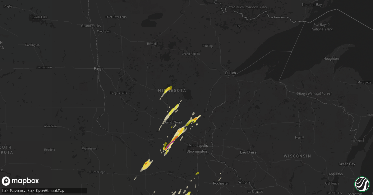
Hail Map in Minnesota on March 6, 2017
Get this storm
March 6 map
$229
one time, instant access
Download today. No call, no setup
Keep the $229
Bought the map and want the full workflow? Apply the entire $229 to a subscription within 7 days. None of it is wasted.
Every map, not just this one
This buys you this map. Subscription and you get every map we run, in the markets you choose from a few cities to whole states to nationwide. Plus real-time alerts the moment a storm fires.
Contact data
Name, contact info, occupancy, even credit band for addresses in the footprint. You go from where it hit to who to call.
Become the source they trust
Unlimited branding weather history reports on demand. You already have the documented answer ready for the property owner, and you are the one who showed up with it.
Property data and RoofTrace estimates
Pull up any address you have got, its value and the exact code rules for that jurisdiction, straight from One Click Code. Then RoofTrace estimates the squares, pitch, and roof value, priced the way you price.
Storm reports in Minnesota
Minnesota
| Date | Description |
|---|---|
| 03/06/20175:55 PM CST | . |
| 03/06/20175:52 PM CST | Large oak trees fallen and housing pieces wrapped around trees. Possible tornado damage. |
| 03/06/20175:41 PM CST | Trees down... Power lines down... And part of roof missing. |
| 03/06/20175:39 PM CST | Ef1 tornado surveyed in sherburne county. Peak winds 100 to 110 mph. Path length 8.9 miles. |
| 03/06/20175:38 PM CST | Ef1 tornado surveyed in freeborn county. Peak winds 100 to 110 mph. Path length 12.3 miles. |
| 03/06/20175:20 PM CST | . |
| 03/06/20175:20 PM CST | . |
| 03/06/20175:15 PM CST | Car dents also reported. |
| 03/06/20175:10 PM CST | There were hailstones ranging from 1 to 1.5 inches in diameter. |
| 03/06/20175:06 PM CST | . |
| 03/06/20175:05 PM CST | . |
| 03/06/20175:00 PM CST | . |
| 03/06/20174:57 PM CST | . |
| 03/06/20174:56 PM CST | . |
| 03/06/20174:53 PM CST | . |
| 03/06/20174:52 PM CST | . |
| 03/06/20174:45 PM CST | . |
| 03/06/20174:43 PM CST | . |
| 03/06/20174:42 PM CST | . |
| 03/06/20174:41 PM CST | . |
| 03/06/20174:40 PM CST | . |
| 03/06/20174:35 PM CST | . |
| 03/06/20174:34 PM CST | . |
| 03/06/20174:30 PM CST | Late report. |
| 03/06/20174:04 PM CST | Ef1 tornado surveyed in faribault county. Peak winds 90 mph. Path length 9.6 miles. |
| 03/06/20174:00 PM CST | . |
| 03/06/20173:50 PM CST | Reported at county road 65... Between redwood falls and morton... Mn. |
| 03/06/20173:45 PM CST | . |
| 03/06/20173:40 PM CST | . |
| 03/06/20176:25 AM CST | Several trees down with one on a garage. Time estimated from radar. Report via broadcast media twitter. |
| 03/05/20178:33 PM CST | Roof partially blown off a barn. Time estimated from radar. Report via twitter. |
| 03/05/20178:31 PM CST | Several large pine trees snapped. Two outbuildings destroyed with others damaged. Time estimated from radar. Report via facebook. |
| 03/05/20178:12 PM CST | Large tree blown down on a car and partially on a house. Report via facebook. |
| 03/05/20177:30 PM CST | Small branches down. |
| 03/05/20176:43 PM CST | Several utility poles down. Plus numerous 20 inch diameter trees. |
| 03/05/20176:30 PM CST | Reported at 11144 cr 5 nw... Pine island... Mn. Small portion of roof pealed off house on sw corner via eaves. Downed pine tree. . |
| 03/05/20176:28 PM CST | Shed blown across road and took out some power lines. |
| 03/05/20176:26 PM CST | Large trees blown down and pole building roofs damaged. Time estimated by radar. Report via twitter. |
| 03/05/20176:25 PM CST | Trees down across road. |
| 03/05/20176:22 PM CST | Shed roof ripped off. Old garage torn off foundation and demolished. Trees uprooted. |
| 03/05/20176:11 PM CST | Power out in parts of kasson. |
| 03/05/20176:10 PM CST | 8 to 9 inch diameter trees down. |
| 03/05/20176:08 PM CST | Large trees down across road near u.s. Hwy 169. . |
| 03/05/20176:05 PM CST | . |
| 03/05/20176:03 PM CST | Large grain elevator collapsed along with numerous reports of building damage and around town. |
| 03/05/20176:02 PM CST | Homes and businesses damaged. Many trees down with power outage. |
All States Impacted by Hail Map on March 6, 2017
Cities Impacted by Hail Map on March 6, 2017
- Dunbar, NE
- Syracuse, NE
- Talmage, NE
- Stewart, MN
- Buffalo Lake, MN
- Des Moines, IA
- Nowata, OK
- Chelsea, OK
- Blue Mound, KS
- Kiron, IA
- Vail, IA
- Birch Tree, MO
- Mercer, MO
- Lineville, IA
- Rockville, MO
- Schell City, MO
- Coon Rapids, IA
- Pawhuska, OK
- Yutan, NE
- Persia, IA
- Elkhorn, NE
- Neola, IA
- Boys Town, NE
- Bennington, NE
- Blair, NE
- Honey Creek, IA
- Gretna, NE
- Panama, IA
- Ashland, NE
- Waterloo, NE
- Portsmouth, IA
- Crescent, IA
- Earling, IA
- Woodbine, IA
- Fort Calhoun, NE
- Missouri Valley, IA
- Omaha, NE
- Logan, IA
- Springfield, NE
- Papillion, NE
- Valley, NE
- Prairie Grove, AR
- West Fork, AR
- Canehill, AR
- Natural Dam, AR
- Toledo, IA
- Broken Arrow, OK
- Wellsville, KS
- Hartland, MN
- Cylinder, IA
- Mallard, IA
- Frost, MN
- Kiester, MN
- Ledyard, IA
- Lakota, IA
- Ringsted, IA
- Elmore, MN
- Emmetsburg, IA
- Buffalo Center, IA
- Alden, MN
- Lone Rock, IA
- Wells, MN
- Curlew, IA
- Rake, IA
- Freeborn, MN
- Bricelyn, MN
- Fenton, IA
- Swea City, IA
- Bancroft, IA
- Lenexa, KS
- Oak Grove, MO
- De Soto, KS
- Olathe, KS
- Independence, MO
- Mission, KS
- Linwood, KS
- Overbrook, KS
- Prairie Village, KS
- Bonner Springs, KS
- Kansas City, MO
- Grain Valley, MO
- Buckner, MO
- Leawood, KS
- Overland Park, KS
- Napoleon, MO
- Lawrence, KS
- Quenemo, KS
- Levasy, MO
- Ottawa, KS
- Orrick, MO
- Vassar, KS
- Shawnee, KS
- Sibley, MO
- Pomona, KS
- Eudora, KS
- Kansas City, KS
- Baldwin City, KS
- Evansville, AR
- Chester, AR
- Bunch, OK
- Winslow, AR
- Stilwell, OK
- Ridgeway, MO
- Bethany, MO
- Bartlesville, OK
- Bern, KS
- Braymer, MO
- McLouth, KS
- Humboldt, IA
- Dakota City, IA
- Livermore, IA
- Meriden, KS
- Alexandria, MO
- Kahoka, MO
- Saint Patrick, MO
- Richmond, MN
- Paynesville, MN
- Effingham, KS
- Lyndon, KS
- Emerson, IA
- Griswold, IA
- Red Oak, IA
- Elliott, IA
- Laddonia, MO
- Wellsville, MO
- Princeton, MN
- Dalbo, MN
- Cambridge, MN
- Stanchfield, MN
- Westboro, MO
- Riverton, IA
- Tarkio, MO
- Northboro, IA
- Hamburg, IA
- Shenandoah, IA
- Rock Port, MO
- Farragut, IA
- Sidney, IA
- Coin, IA
- Osage City, KS
- La Grange, MO
- Home, KS
- Marysville, KS
- Gentry, MO
- Carson, IA
- Treynor, IA
- Oakland, IA
- Blue Rapids, KS
- Rockwell, IA
- Sheffield, IA
- Swaledale, IA
- Massena, IA
- Cumberland, IA
- Waverly, MO
- Corder, MO
- Norborne, MO
- Carrollton, MO
- Plattsburg, MO
- Stewartsville, MO
- Leavenworth, KS
- Gower, MO
- Platte City, MO
- Trimble, MO
- Oskaloosa, KS
- Smithville, MO
- Edgerton, MO
- Camden Point, MO
- Lathrop, MO
- Dearborn, MO
- Weston, MO
- Easton, KS
- Fort Leavenworth, KS
- Burns, KS
- New Virginia, IA
- Fairmont, MN
- Worth, MO
- Grant City, MO
- Sheridan, MO
- Maryville, MO
- Ravenwood, MO
- Hatfield, MO
- Parnell, MO
- Albany, MO
- Conception Junction, MO
- Denver, MO
- Clyde, MO
- Barnard, MO
- Martinsville, MO
- Stanberry, MO
- Cummings, KS
- Atchison, KS
- Eskridge, KS
- Tabor, IA
- Thurman, IA
- Prague, OK
- Tulsa, OK
- Choctaw, OK
- Bristow, OK
- Mcloud, OK
- Carney, OK
- Seminole, OK
- Okemah, OK
- Earlsboro, OK
- Depew, OK
- Noble, OK
- Sparks, OK
- Harrah, OK
- Tryon, OK
- Davenport, OK
- Bixby, OK
- Tecumseh, OK
- Newalla, OK
- Glenpool, OK
- Agra, OK
- Shawnee, OK
- Boley, OK
- Castle, OK
- Mounds, OK
- Paden, OK
- Meeker, OK
- Chandler, OK
- Norman, OK
- Drumright, OK
- Wellston, OK
- Jenks, OK
- Stroud, OK
- Wewoka, OK
- Cushing, OK
- Kellyville, OK
- Beggs, OK
- Macomb, OK
- Sapulpa, OK
- Mound City, KS
- Pleasanton, KS
- Prescott, KS
- Rich Hill, MO
- Hume, MO
- Hutchinson, MN
- Glencoe, MN
- Brownton, MN
- Foley, MN
- Pierz, MN
- Royalton, MN
- Rice, MN
- Hillman, MN
- Pilot Mound, IA
- Yorktown, IA
- Nodaway, IA
- Essex, IA
- Clarinda, IA
- Villisca, IA
- La Farge, WI
- Farber, MO
- Mountain Home, AR
- Saint Joe, AR
- Yellville, AR
- Norfork, AR
- Flippin, AR
- West Plains, MO
- Mountain View, MO
- Peace Valley, MO
- Pomona, MO
- Monticello, MN
- Big Lake, MN
- Becker, MN
- Harmony, MN
- Newton, IA
- Emmons, MN
- Scarville, IA
- Thompson, IA
- Liberty, MO
- Correctionville, IA
- Cushing, IA
- Oto, IA
- Anthon, IA
- Danbury, IA
- Battle Creek, IA
- Holstein, IA
- La Vista, NE
- Waukee, IA
- West Des Moines, IA
- Cokato, MN
- Silver City, IA
- Rockwell City, IA
- Paxico, KS
- Carroll, IA
- Glidden, IA
- Halbur, IA
- Lake City, IA
- Lidderdale, IA
- Lohrville, IA
- Arcadia, IA
- Lanesboro, IA
- Westside, IA
- Manning, IA
- West Point, IL
- Admire, KS
- Elmer, MO
- Atlanta, MO
- Malta Bend, MO
- Emporia, KS
- Strong City, KS
- Cottonwood Falls, KS
- Belvue, KS
- Nebraska City, NE
- Goldfield, IA
- Hardy, IA
- Eagle Grove, IA
- Thor, IA
- Martinsburg, MO
- Montgomery City, MO
- Columbia, MO
- Foster, MO
- Isanti, MN
- Clare, IA
- Moorland, IA
- Fort Dodge, IA
- Barnum, IA
- New Richland, MN
- Waldorf, MN
- Blue Earth, MN
- Delavan, MN
- Winnebago, MN
- Webster City, IA
- Yates Center, KS
- Saint Marys, KS
- Maple Hill, KS
- Delia, KS
- Princeton, KS
- Alma, KS
- Alta Vista, KS
- Hardin, MO
- Gravity, IA
- Cedar Vale, KS
- Sedan, KS
- Peru, KS
- Elk City, KS
- Cushing, MN
- Creston, IA
- Lenox, IA
- Prescott, IA
- Lenapah, OK
- Wann, OK
- Britt, IA
- Woden, IA
- Summers, AR
- Lincoln, AR
- Westville, OK
- Olsburg, KS
- Redwood Falls, MN
- Morton, MN
- Franklin, MN
- Wabasso, MN
- Olivia, MN
- Clements, MN
- Lamberton, MN
- Morgan, MN
- Pilot Grove, MO
- Bunceton, MO
- Rodney, IA
- Smithland, IA
- Galva, IA
- Valley Falls, KS
- Nortonville, KS
- Hanover, KS
- El Dorado, KS
- Augusta, KS
- Prue, OK
- Cleveland, OK
- Osage, OK
- Duncombe, IA
- Otho, IA
- Lehigh, IA
- Gowrie, IA
- Corning, IA
- Du Bois, NE
- Humboldt, NE
- Pawnee City, NE
- Whiting, KS
- Netawaka, KS
- Muscotah, KS
- Marshall, MO
- Gore, OK
- Vian, OK
- Glasgow, MO
- Beattie, KS
- Burchard, NE
- Waterville, KS
- Summerfield, KS
- Oketo, KS
- Spencer, IA
- Dickens, IA
- Zimmerman, MN
- Lu Verne, IA
- Corwith, IA
- Wesley, IA
- Algona, IA
- Higginsville, MO
- Tecumseh, NE
- Reasnor, IA
- Churdan, IA
- Burnside, IA
- Paton, IA
- Vincent, IA
- Callender, IA
- Farnhamville, IA
- Faribault, MN
- Council Grove, KS
- Harlan, IA
- Defiance, IA
- Dunlap, IA
- Ithaca, NE
- Brock, NE
- Steinauer, NE
- Peru, NE
- Johnson, NE
- Elk Creek, NE
- Auburn, NE
- Hallsville, MO
- Rippey, IA
- Grand Junction, IA
- Matfield Green, KS
- Madison, KS
- Cook, NE
- Jones, OK
- Luther, OK
- Winterset, IA
- Peru, IA
- Junction City, KS
- Independence, KS
- Somers, IA
- Viola, WI
- Readstown, WI
- Viroqua, WI
- Cashton, WI
- Ontario, WI
- Westby, WI
- Sweet Springs, MO
- Hoyt, KS
- Denison, KS
- Mayetta, KS
- Unadilla, NE
- Glenwood, IA
- Malvern, IA
- Pacific Junction, IA
- Norwalk, IA
- Cumming, IA
- Van Meter, IA
- Prole, IA
- Big Cabin, OK
- Holton, KS
- Oronoco, MN
- Rochester, MN
- Crab Orchard, NE
- Neodesha, KS
- Cherryvale, KS
- Quincy, IL
- Ewing, MO
- Canton, MO
- Durham, MO
- Maywood, MO
- Ursa, IL
- Runnells, IA
- Lorimor, IA
- Orient, IA
- Greenfield, IA
- Carlisle, IA
- Prairie City, IA
- Macksburg, IA
- Mitchellville, IA
- Hartford, IA
- Pleasant Hill, IA
- Indianola, IA
- Seneca, KS
- Baileyville, KS
- Frankfort, KS
- Cookson, OK
- Dassel, MN
- Buffalo, MN
- Annandale, MN
- Elk River, MN
- Maple Lake, MN
- Silver Lake, MN
- Clearwater, MN
- Howard Lake, MN
- Clear Lake, MN
- Falls City, NE
- Richmond, MO
- Excelsior Springs, MO
- Rayville, MO
- Kincaid, KS
- Braham, MN
- Salisbury, MO
- Ponca, AR
- Jasper, AR
- Industry, IL
- Chillicothe, MO
- Utica, MO
- Mooresville, MO
- Wamego, KS
- Renwick, IA
- Scranton, IA
- Jefferson, IA
- Manson, IA
- Badger, IA
- Harcourt, IA
- Woolstock, IA
- Dayton, IA
- Wynona, OK
- Hominy, OK
- Barnsdall, OK
- Lewiston, NE
- Ellendale, MN
- Truro, IA
- Danville, AR
- Belleville, AR
- Dardanelle, AR
- Ola, AR
- Percival, IA
- Randolph, IA
- Easton, MN
- Houston, MN
- Mabel, MN
- Spring Grove, MN
- Witter, AR
- Combs, AR
- Maysville, MO
- Brainerd, MN
- Lake City, MN
- Baxter, MN
- Blackwater, MO
- Boonville, MO
- Jamesport, MO
- Gallatin, MO
- Dawson, NE
- Verdon, NE
- Talala, OK
- Avoca, NE
- Otoe, NE
- Claremore, OK
- Virgil, KS
- Hamilton, KS
- Washta, IA
- Dallas Center, IA
- Minburn, IA
- Adel, IA
- Lees Summit, MO
- Raymore, MO
- Ackworth, IA
- Milo, IA
- Stella, NE
- Wathena, KS
- Cosby, MO
- Saint Joseph, MO
- Hamilton, MO
- Cainsville, MO
- Ludlow, MO
- Burr, NE
- Sterling, NE
- Parthenon, AR
- Western Grove, AR
- Harrison, AR
- Kingston, AR
- Hasty, AR
- Van Buren, AR
- Cedarville, AR
- Dana, IA
- Cresco, IA
- Lime Springs, IA
- Pillager, MN
- Palmyra, MO
- Ayrshire, IA
- Graettinger, IA
- Ruthven, IA
- Pattonsburg, MO
- Bucyrus, KS
- Spring Hill, KS
- Dwight, KS
- Rockford, IA
- Mason City, IA
- Shelbyville, MO
- Bethel, MO
- Auxvasse, MO
- Owasso, OK
- Catoosa, OK
- Agency, MO
- Faucett, MO
- Macon, MO
- Alpha, MN
- Jackson, MN
- Fontanelle, IA
- Adair, IA
- Salem, AR
- Moravia, IA
- La Belle, MO
- Council Bluffs, IA
- Clear Lake, IA
- Silex, MO
- Okmulgee, OK
- Wymore, NE
- Blue Springs, NE
- Beatrice, NE
- Cowgill, MO
- Polo, MO
- Lawson, MO
- Exira, IA
- Audubon, IA
- Tonganoxie, KS
- Vendor, AR
- Everton, AR
- Huntsville, AR
- Pindall, AR
- Compton, AR
- Elkins, AR
- Marble Falls, AR
- Scranton, KS
- Carbondale, KS
- Nehawka, NE
- Leon, KS
- Westmoreland, KS
- Manhattan, KS
- Lake Mills, IA
- Riceville, IA
- Weeping Water, NE
- Mineola, IA
- Plattsmouth, NE
- Hastings, IA
- Douglas, NE
- Union, NE
- Murray, NE
- Adams, NE
- Shelby, IA
- Avoca, IA
- Dora, MO
- Zanoni, MO
- Pottersville, MO
- Higbee, MO
- Fayette, MO
- Basehor, KS
- Orchard, IA
- Osage, IA
- Rudd, IA
- Elma, IA
- Floyd, IA
- Marengo, IA
- Watkins, IA
- Bowlus, MN
- Calhoun, MO
- Windsor, MO
- Grinnell, IA
- Kellogg, IA
- Woodward, IA
- Madrid, IA
- Newark, MO
- Princeton, MO
- Ladora, IA
- Victor, IA
- Knierim, IA
- Breda, IA
- Ralston, IA
- Manilla, IA
- Bevier, MO
- Harrisburg, MO
- Lewistown, MO
- Saint Cloud, MN
- Bremen, KS
- Howard, KS
- Gladbrook, IA
- Lincoln, IA
- Reinbeck, IA
- Coweta, OK
- Saint Francis, MN
- Lexington, MO
- Dover, MO
- Grafton, IL
- Harrisonville, MO
- Pleasant Hill, MO
- Bogard, MO
- Mannford, OK
- Houstonia, MO
- Hughesville, MO
- Hamlin, IA
- Neosho Falls, KS
- Westphalia, KS
- Le Roy, KS
- Colony, KS
- Welda, KS
- Clarion, IA
- Galt, IA
- Adair, IL
- Hancock, IA
- Marne, IA
- Walnut, IA
- Oklahoma City, OK
- Americus, KS
- Sand Springs, OK
- Saint George, KS
- Rushville, IL
- Rossville, KS
- Emmett, KS
- Armstrong, IA
- Kingsville, MO
- Centralia, MO
- Olpe, KS
- Yale, OK
- Emden, MO
- Philadelphia, MO
- Avon, MN
- Easton, MO
- Saint Joseph, MN
- Holdingford, MN
- Everest, KS
- Sutter, IL
- Warsaw, IL
- Walnut Grove, MN
- Currie, MN
- Ripley, OK
- Perkins, OK
- Wall Lake, IA
- Auburn, IA
- Lake View, IA
- Kingston, MO
- Cameron, MO
- Rowan, IA
- Earlham, IA
- De Soto, IA
- Owatonna, MN
- Rushville, MO
- Waterloo, IL
- Valmeyer, IL
- Hawk Point, MO
- Alexander, IA
- Kearney, MO
- Holt, MO
- Julian, NE
- Virginia, NE
- Liberty, NE
- Blanchard, IA
- New Market, IA
- Camp Point, IL
- Clayton, IL
- Liberty, IL
- Waverly, KS
- Melvern, KS
- Cromwell, IA
- Chelsea, IA
- Clarence, MO
- Mendon, IL
- Leonard, MO
- Anabel, MO
- Linden, IA
- Perry, IA
- Dawson, IA
- Browning, IL
- Astoria, IL
- Auburn, KS
- Harveyville, KS
- Sturgeon, MO
- Clark, MO
- Elwood, KS
- Reading, KS
- Burlingame, KS
- Alma, MO
- Fairfax, OK
- Skiatook, OK
- Edgerton, KS
- Decatur, NE
- Knoxville, IA
- Pleasantville, IA
- Maitland, MO
- Rosalia, KS
- Cassoday, KS
- Eureka, KS
- Madill, OK
- Skidmore, MO
- Graham, MO
- Valley Springs, AR
- Granada, MN
- Brayton, IA
- Thompson, MO
- New Franklin, MO
- Rocheport, MO
- Mexico, MO
- Ramona, OK
- Ochelata, OK
- Mendon, MO
- Rantoul, KS
- Osawatomie, KS
- Milaca, MN
- Ogilvie, MN
- Turney, MO
- Bayard, IA
- Bagley, IA
- Thornton, IA
- Dougherty, IA
- Trenton, MO
- Deep River, IA
- Montezuma, IA
- Saint Stephen, MN
- Seymour, IA
- Stanton, IA
- Carbon, IA
- Liberty, KS
- Dearing, KS
- Caney, KS
- Coffeyville, KS
- Tyro, KS
- Niotaze, KS
- Copan, OK
- Waldron, MO
- Paola, KS
- Louisburg, KS
- Onaga, KS
- Kimball, MN
- Odell, NE
- Wheeling, MO
- Linneus, MO
- Chula, MO
- Grundy Center, IA
- Aurelia, IA
- Cherokee, IA
- Henrietta, MO
- Altoona, IA
- Macedonia, IA
- Redfield, IA
- Cedar Falls, IA
- Hudson, IA
- Waterloo, IA
- Monticello, MO
- Leland, IA
- Horton, KS
- Topeka, KS
- Grantville, KS
- Dunkerton, IA
- Fairbank, IA
- Miami, MO
- Blackburn, MO
- Calico Rock, AR
- Malcom, IA
- Gibbs, MO
- La Plata, MO
- Edina, MO
- Hurdland, MO
- Novelty, MO
- Brashear, MO
- Baring, MO
- Tupelo, OK
- Coalgate, OK
- Centrahoma, OK
- Durant, OK
- Mead, OK
- Delaware, OK
- Tishomingo, OK
- Fowler, IL
- La Monte, MO
- Knob Noster, MO
- Axtell, KS
- Shubert, NE
- Salem, NE
- Cedar Rapids, IA
- Fairfax, IA
- Marion, IA
- Norway, IA
- Walford, IA
- Washington, OK
- Augusta, IL
- Bowen, IL
- Henderson, IA
- Hampton, IA
- Dows, IA
- Latimer, IA
- Bosworth, MO
- Trimont, MN
- Panora, IA
- Blairsburg, IA
- Conger, MN
- Albert Lea, MN
- Dow City, IA
- Monroe, IA
- Marceline, MO
- Brooklyn, IA
- Dawn, MO
- Hale, MO
- Tina, MO
- Sumner, MO
- Little Falls, MN
- Wallingford, IA
- Estherville, IA
- Dolliver, IA
- Grimes, IA
- Jennings, OK
- Gardner, KS
- Darwin, MN
- Litchfield, MN
- Spencer, OK
- Lewis, IA
- Amity, MO
- Weatherby, MO
- Coffey, MO
- Burbank, OK
- Afton, IA
- Imogene, IA
- Mystic, IA
- Centerville, IA
- Alta, IA
- Storm Lake, IA
- Bexar, AR
- Dolph, AR
- Fulton, MO
- Stilwell, KS
- Belton, MO
- Greenwood, MO
- Lentner, MO
- Callao, MO
- Montrose, MN
- Sully, IA
- Lynnville, IA
- Waseca, MN
- Milburn, OK
- Wapanucka, OK
- Forest City, IA
- Modale, IA
- Minnesota Lake, MN
- Laurens, IA
- Burt, IA
- Titonka, IA
- Whittemore, IA
- Bridgewater, IA
- Crystal Lake, IA
- Mapleton, KS
- Benton City, MO
- Gorin, MO
- Rutledge, MO
- Terlton, OK
- Williamstown, MO
- Zumbro Falls, MN
- Kidder, MO
- Adair, OK
- Altamont, KS
- Edna, KS
- Bellflower, MO
- Middletown, MO
- Jamaica, IA
- Yale, IA
- Johnston, IA
- Lytton, IA
- Onawa, IA
- Cold Spring, MN
- Sallisaw, OK
- Williamsburg, KS
- La Crosse, WI
- Vermillion, KS
- Centralia, KS
- Lone Jack, MO
- Blue Springs, MO
- Stuart, IA
- Dexter, IA
- Winchester, KS
- New Hampton, MO
- Blythedale, MO
- Conception, MO
- Eagleville, MO
- Freeman, MO
- Glencoe, AR
- Warrensburg, MO
- Camden, MO
- Wellington, MO
- New Century, KS
- Grandview, MO
- Kirkman, IA
- Irwin, IA
- Nelson, MO
- Perry, KS
- Elk Horn, IA
- Atlantic, IA
- Clive, IA
- Urbandale, IA
- Traer, IA
- Allen, KS
- Tecumseh, MO
- Gainesville, MO
- Neosho Rapids, KS
- Weleetka, OK
- Sedalia, MO
- Otterville, MO
- Smithton, MO
- Alta Vista, IA
- New Hampton, IA
- Keosauqua, IA
- Mount Sterling, IA
- Hollenberg, KS
- Mound City, MO
- Fairfax, MO
- Shelbina, MO
- Loraine, IL
- New Cambria, MO
- Bunker Hill, IL
- Saint Charles, IA
- Denison, IA
- Charter Oak, IA
- Oakland, NE
- Silver Lake, KS
- Wyaconda, MO
- Bates City, MO
- Odessa, MO
- Pryor, OK
- Arcadia, OK
- Lexington, OK
- Nisswa, MN
- Amana, IA
- Springville, IA
- Mount Vernon, IA
- Kanawha, IA
- Nora Springs, IA
- Otley, IA
- Pella, IA
- Fayetteville, AR
- Pettigrew, AR
- Waldron, AR
- New Bloomfield, MO
- Beardstown, IL
- Frederick, IL
- Maquon, IL
- London Mills, IL


