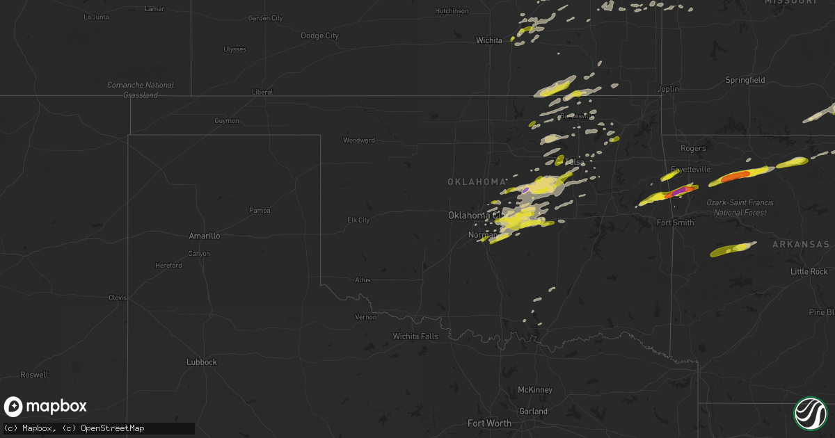
Hail Map in Oklahoma on March 6, 2017
Get this storm
March 6 map
$229
one time, instant access
Download today. No call, no setup
Keep the $229
Bought the map and want the full workflow? Apply the entire $229 to a subscription within 7 days. None of it is wasted.
Every map, not just this one
This buys you this map. Subscription and you get every map we run, in the markets you choose from a few cities to whole states to nationwide. Plus real-time alerts the moment a storm fires.
Contact data
Name, contact info, occupancy, even credit band for addresses in the footprint. You go from where it hit to who to call.
Become the source they trust
Unlimited branding weather history reports on demand. You already have the documented answer ready for the property owner, and you are the one who showed up with it.
Property data and RoofTrace estimates
Pull up any address you have got, its value and the exact code rules for that jurisdiction, straight from One Click Code. Then RoofTrace estimates the squares, pitch, and roof value, priced the way you price.
Storm reports in Oklahoma
Oklahoma
| Date | Description |
|---|---|
| 03/06/20172:00 AM CST | Several large tree limbs down |
| 03/06/20171:55 AM CST | Outdoor shed roof damaged |
| 03/06/201712:54 AM CST | Large tree limb down blocking a road |
| 03/06/201712:45 AM CST | A local report indicates 64 MPH wind near 2 SW WILBURTON |
| 03/06/201712:05 AM CST | 3-4 inch diameter limbs down. |
| 03/05/201711:40 PM CST | Damage to church on side side of city from thunderstorm winds. |
| 03/05/201711:20 PM CST | Sheet metal damage to building |
| 03/05/201711:09 PM CST | Tree limbs downed by thunderstorm winds. |
| 03/05/201711:07 PM CST | Roof damage to church |
| 03/05/201710:58 PM CST | Damage to buildings and roof damage from thunderstorm winds. |
| 03/05/201710:51 PM CST | Shingles blown off roof... Siding blown off homes. |
| 03/05/201710:45 PM CST | Housing for boats were damaged on spavinaw lake. 2 housing units were flipped... Several others had roof damage. |
| 03/05/201710:43 PM CST | Tree blown down onto vehicle on peoria avenue. |
| 03/05/201710:42 PM CST | Outbuilding damaged by thunderstorm winds. |
| 03/05/201710:37 PM CST | 5 power poles snapped on memorial just south of 121st. |
| 03/05/201710:35 PM CST | A local report indicates 1.00 inch wind near ADAIR |
| 03/05/201710:28 PM CST | Quarter hail. Hardesty and gordon cooper. |
| 03/05/201710:21 PM CST | A local report indicates 1.00 inch wind near 3 E SAPULPA |
| 03/05/201710:20 PM CST | Large tree limb downed. Time estimated via radar. |
| 03/05/201710:20 PM CST | Few large trees down and mobile home overturned |
| 03/05/201710:16 PM CST | Social media report |
| 03/05/201710:15 PM CST | 5 power poles snapped |
| 03/05/201710:11 PM CST | A local report indicates 1.00 inch wind near 1 NE SHAWNEE |
| 03/05/201710:11 PM CST | A local report indicates 1.25 inch wind near 1 W PRAGUE |
| 03/05/201710:09 PM CST | Nickel and quarter hail. |
| 03/05/201710:00 PM CST | A local report indicates 60 MPH wind near 7 E CENTRAILIA |
| 03/05/201710:00 PM CST | Relayed via media |
| 03/05/201710:00 PM CST | . |
| 03/05/201710:00 PM CST | Several tree limbs down. Flag pole blown down. |
| 03/05/20179:57 PM CST | Trees down and shed overturned with preceding gust front |
| 03/05/20179:55 PM CST | Highway 412 and 209th west avenue |
| 03/05/20179:55 PM CST | A local report indicates 1.00 inch wind near 4 SSE NORMAN |
| 03/05/20179:53 PM CST | Hail reported just north of greasy |
| 03/05/20179:50 PM CST | A local report indicates 1.75 inch wind near 4 S STILWELL |
| 03/05/20179:48 PM CST | Power poles down |
| 03/05/20179:45 PM CST | Ef1. Max winds 90-100 mph. Homes and outbuildings damaged. Trees uprooted and some snapped. |
| 03/05/20179:45 PM CST | A local report indicates 66 MPH wind near 7 E CENTRAILIA |
| 03/05/20179:20 PM CST | Three sections of wooden privacy fence blown down and tree blown over |
| 03/05/20179:15 PM CST | Numerous hail reports relayed. Sent via social media. |
| 03/05/20179:03 PM CST | Dime and quarter hail. |
| 03/05/20178:59 PM CST | A local report indicates 1.00 inch wind near 1 S CARNEY |
| 03/05/20178:25 PM CST | A local report indicates 67 MPH wind near FORAKER |
All States Impacted by Hail Map on March 6, 2017
Cities Impacted by Hail Map on March 6, 2017
- Dunbar, NE
- Syracuse, NE
- Talmage, NE
- Stewart, MN
- Buffalo Lake, MN
- Des Moines, IA
- Nowata, OK
- Chelsea, OK
- Blue Mound, KS
- Kiron, IA
- Vail, IA
- Birch Tree, MO
- Mercer, MO
- Lineville, IA
- Rockville, MO
- Schell City, MO
- Coon Rapids, IA
- Pawhuska, OK
- Yutan, NE
- Persia, IA
- Elkhorn, NE
- Neola, IA
- Boys Town, NE
- Bennington, NE
- Blair, NE
- Honey Creek, IA
- Gretna, NE
- Panama, IA
- Ashland, NE
- Waterloo, NE
- Portsmouth, IA
- Crescent, IA
- Earling, IA
- Woodbine, IA
- Fort Calhoun, NE
- Missouri Valley, IA
- Omaha, NE
- Logan, IA
- Springfield, NE
- Papillion, NE
- Valley, NE
- Prairie Grove, AR
- West Fork, AR
- Canehill, AR
- Natural Dam, AR
- Toledo, IA
- Broken Arrow, OK
- Wellsville, KS
- Hartland, MN
- Cylinder, IA
- Mallard, IA
- Frost, MN
- Kiester, MN
- Ledyard, IA
- Lakota, IA
- Ringsted, IA
- Elmore, MN
- Emmetsburg, IA
- Buffalo Center, IA
- Alden, MN
- Lone Rock, IA
- Wells, MN
- Curlew, IA
- Rake, IA
- Freeborn, MN
- Bricelyn, MN
- Fenton, IA
- Swea City, IA
- Bancroft, IA
- Lenexa, KS
- Oak Grove, MO
- De Soto, KS
- Olathe, KS
- Independence, MO
- Mission, KS
- Linwood, KS
- Overbrook, KS
- Prairie Village, KS
- Bonner Springs, KS
- Kansas City, MO
- Grain Valley, MO
- Buckner, MO
- Leawood, KS
- Overland Park, KS
- Napoleon, MO
- Lawrence, KS
- Quenemo, KS
- Levasy, MO
- Ottawa, KS
- Orrick, MO
- Vassar, KS
- Shawnee, KS
- Sibley, MO
- Pomona, KS
- Eudora, KS
- Kansas City, KS
- Baldwin City, KS
- Evansville, AR
- Chester, AR
- Bunch, OK
- Winslow, AR
- Stilwell, OK
- Ridgeway, MO
- Bethany, MO
- Bartlesville, OK
- Bern, KS
- Braymer, MO
- McLouth, KS
- Humboldt, IA
- Dakota City, IA
- Livermore, IA
- Meriden, KS
- Alexandria, MO
- Kahoka, MO
- Saint Patrick, MO
- Richmond, MN
- Paynesville, MN
- Effingham, KS
- Lyndon, KS
- Emerson, IA
- Griswold, IA
- Red Oak, IA
- Elliott, IA
- Laddonia, MO
- Wellsville, MO
- Princeton, MN
- Dalbo, MN
- Cambridge, MN
- Stanchfield, MN
- Westboro, MO
- Riverton, IA
- Tarkio, MO
- Northboro, IA
- Hamburg, IA
- Shenandoah, IA
- Rock Port, MO
- Farragut, IA
- Sidney, IA
- Coin, IA
- Osage City, KS
- La Grange, MO
- Home, KS
- Marysville, KS
- Gentry, MO
- Carson, IA
- Treynor, IA
- Oakland, IA
- Blue Rapids, KS
- Rockwell, IA
- Sheffield, IA
- Swaledale, IA
- Massena, IA
- Cumberland, IA
- Waverly, MO
- Corder, MO
- Norborne, MO
- Carrollton, MO
- Plattsburg, MO
- Stewartsville, MO
- Leavenworth, KS
- Gower, MO
- Platte City, MO
- Trimble, MO
- Oskaloosa, KS
- Smithville, MO
- Edgerton, MO
- Camden Point, MO
- Lathrop, MO
- Dearborn, MO
- Weston, MO
- Easton, KS
- Fort Leavenworth, KS
- Burns, KS
- New Virginia, IA
- Fairmont, MN
- Worth, MO
- Grant City, MO
- Sheridan, MO
- Maryville, MO
- Ravenwood, MO
- Hatfield, MO
- Parnell, MO
- Albany, MO
- Conception Junction, MO
- Denver, MO
- Clyde, MO
- Barnard, MO
- Martinsville, MO
- Stanberry, MO
- Cummings, KS
- Atchison, KS
- Eskridge, KS
- Tabor, IA
- Thurman, IA
- Prague, OK
- Tulsa, OK
- Choctaw, OK
- Bristow, OK
- Mcloud, OK
- Carney, OK
- Seminole, OK
- Okemah, OK
- Earlsboro, OK
- Depew, OK
- Noble, OK
- Sparks, OK
- Harrah, OK
- Tryon, OK
- Davenport, OK
- Bixby, OK
- Tecumseh, OK
- Newalla, OK
- Glenpool, OK
- Agra, OK
- Shawnee, OK
- Boley, OK
- Castle, OK
- Mounds, OK
- Paden, OK
- Meeker, OK
- Chandler, OK
- Norman, OK
- Drumright, OK
- Wellston, OK
- Jenks, OK
- Stroud, OK
- Wewoka, OK
- Cushing, OK
- Kellyville, OK
- Beggs, OK
- Macomb, OK
- Sapulpa, OK
- Mound City, KS
- Pleasanton, KS
- Prescott, KS
- Rich Hill, MO
- Hume, MO
- Hutchinson, MN
- Glencoe, MN
- Brownton, MN
- Foley, MN
- Pierz, MN
- Royalton, MN
- Rice, MN
- Hillman, MN
- Pilot Mound, IA
- Yorktown, IA
- Nodaway, IA
- Essex, IA
- Clarinda, IA
- Villisca, IA
- La Farge, WI
- Farber, MO
- Mountain Home, AR
- Saint Joe, AR
- Yellville, AR
- Norfork, AR
- Flippin, AR
- West Plains, MO
- Mountain View, MO
- Peace Valley, MO
- Pomona, MO
- Monticello, MN
- Big Lake, MN
- Becker, MN
- Harmony, MN
- Newton, IA
- Emmons, MN
- Scarville, IA
- Thompson, IA
- Liberty, MO
- Correctionville, IA
- Cushing, IA
- Oto, IA
- Anthon, IA
- Danbury, IA
- Battle Creek, IA
- Holstein, IA
- La Vista, NE
- Waukee, IA
- West Des Moines, IA
- Cokato, MN
- Silver City, IA
- Rockwell City, IA
- Paxico, KS
- Carroll, IA
- Glidden, IA
- Halbur, IA
- Lake City, IA
- Lidderdale, IA
- Lohrville, IA
- Arcadia, IA
- Lanesboro, IA
- Westside, IA
- Manning, IA
- West Point, IL
- Admire, KS
- Elmer, MO
- Atlanta, MO
- Malta Bend, MO
- Emporia, KS
- Strong City, KS
- Cottonwood Falls, KS
- Belvue, KS
- Nebraska City, NE
- Goldfield, IA
- Hardy, IA
- Eagle Grove, IA
- Thor, IA
- Martinsburg, MO
- Montgomery City, MO
- Columbia, MO
- Foster, MO
- Isanti, MN
- Clare, IA
- Moorland, IA
- Fort Dodge, IA
- Barnum, IA
- New Richland, MN
- Waldorf, MN
- Blue Earth, MN
- Delavan, MN
- Winnebago, MN
- Webster City, IA
- Yates Center, KS
- Saint Marys, KS
- Maple Hill, KS
- Delia, KS
- Princeton, KS
- Alma, KS
- Alta Vista, KS
- Hardin, MO
- Gravity, IA
- Cedar Vale, KS
- Sedan, KS
- Peru, KS
- Elk City, KS
- Cushing, MN
- Creston, IA
- Lenox, IA
- Prescott, IA
- Lenapah, OK
- Wann, OK
- Britt, IA
- Woden, IA
- Summers, AR
- Lincoln, AR
- Westville, OK
- Olsburg, KS
- Redwood Falls, MN
- Morton, MN
- Franklin, MN
- Wabasso, MN
- Olivia, MN
- Clements, MN
- Lamberton, MN
- Morgan, MN
- Pilot Grove, MO
- Bunceton, MO
- Rodney, IA
- Smithland, IA
- Galva, IA
- Valley Falls, KS
- Nortonville, KS
- Hanover, KS
- El Dorado, KS
- Augusta, KS
- Prue, OK
- Cleveland, OK
- Osage, OK
- Duncombe, IA
- Otho, IA
- Lehigh, IA
- Gowrie, IA
- Corning, IA
- Du Bois, NE
- Humboldt, NE
- Pawnee City, NE
- Whiting, KS
- Netawaka, KS
- Muscotah, KS
- Marshall, MO
- Gore, OK
- Vian, OK
- Glasgow, MO
- Beattie, KS
- Burchard, NE
- Waterville, KS
- Summerfield, KS
- Oketo, KS
- Spencer, IA
- Dickens, IA
- Zimmerman, MN
- Lu Verne, IA
- Corwith, IA
- Wesley, IA
- Algona, IA
- Higginsville, MO
- Tecumseh, NE
- Reasnor, IA
- Churdan, IA
- Burnside, IA
- Paton, IA
- Vincent, IA
- Callender, IA
- Farnhamville, IA
- Faribault, MN
- Council Grove, KS
- Harlan, IA
- Defiance, IA
- Dunlap, IA
- Ithaca, NE
- Brock, NE
- Steinauer, NE
- Peru, NE
- Johnson, NE
- Elk Creek, NE
- Auburn, NE
- Hallsville, MO
- Rippey, IA
- Grand Junction, IA
- Matfield Green, KS
- Madison, KS
- Cook, NE
- Jones, OK
- Luther, OK
- Winterset, IA
- Peru, IA
- Junction City, KS
- Independence, KS
- Somers, IA
- Viola, WI
- Readstown, WI
- Viroqua, WI
- Cashton, WI
- Ontario, WI
- Westby, WI
- Sweet Springs, MO
- Hoyt, KS
- Denison, KS
- Mayetta, KS
- Unadilla, NE
- Glenwood, IA
- Malvern, IA
- Pacific Junction, IA
- Norwalk, IA
- Cumming, IA
- Van Meter, IA
- Prole, IA
- Big Cabin, OK
- Holton, KS
- Oronoco, MN
- Rochester, MN
- Crab Orchard, NE
- Neodesha, KS
- Cherryvale, KS
- Quincy, IL
- Ewing, MO
- Canton, MO
- Durham, MO
- Maywood, MO
- Ursa, IL
- Runnells, IA
- Lorimor, IA
- Orient, IA
- Greenfield, IA
- Carlisle, IA
- Prairie City, IA
- Macksburg, IA
- Mitchellville, IA
- Hartford, IA
- Pleasant Hill, IA
- Indianola, IA
- Seneca, KS
- Baileyville, KS
- Frankfort, KS
- Cookson, OK
- Dassel, MN
- Buffalo, MN
- Annandale, MN
- Elk River, MN
- Maple Lake, MN
- Silver Lake, MN
- Clearwater, MN
- Howard Lake, MN
- Clear Lake, MN
- Falls City, NE
- Richmond, MO
- Excelsior Springs, MO
- Rayville, MO
- Kincaid, KS
- Braham, MN
- Salisbury, MO
- Ponca, AR
- Jasper, AR
- Industry, IL
- Chillicothe, MO
- Utica, MO
- Mooresville, MO
- Wamego, KS
- Renwick, IA
- Scranton, IA
- Jefferson, IA
- Manson, IA
- Badger, IA
- Harcourt, IA
- Woolstock, IA
- Dayton, IA
- Wynona, OK
- Hominy, OK
- Barnsdall, OK
- Lewiston, NE
- Ellendale, MN
- Truro, IA
- Danville, AR
- Belleville, AR
- Dardanelle, AR
- Ola, AR
- Percival, IA
- Randolph, IA
- Easton, MN
- Houston, MN
- Mabel, MN
- Spring Grove, MN
- Witter, AR
- Combs, AR
- Maysville, MO
- Brainerd, MN
- Lake City, MN
- Baxter, MN
- Blackwater, MO
- Boonville, MO
- Jamesport, MO
- Gallatin, MO
- Dawson, NE
- Verdon, NE
- Talala, OK
- Avoca, NE
- Otoe, NE
- Claremore, OK
- Virgil, KS
- Hamilton, KS
- Washta, IA
- Dallas Center, IA
- Minburn, IA
- Adel, IA
- Lees Summit, MO
- Raymore, MO
- Ackworth, IA
- Milo, IA
- Stella, NE
- Wathena, KS
- Cosby, MO
- Saint Joseph, MO
- Hamilton, MO
- Cainsville, MO
- Ludlow, MO
- Burr, NE
- Sterling, NE
- Parthenon, AR
- Western Grove, AR
- Harrison, AR
- Kingston, AR
- Hasty, AR
- Van Buren, AR
- Cedarville, AR
- Dana, IA
- Cresco, IA
- Lime Springs, IA
- Pillager, MN
- Palmyra, MO
- Ayrshire, IA
- Graettinger, IA
- Ruthven, IA
- Pattonsburg, MO
- Bucyrus, KS
- Spring Hill, KS
- Dwight, KS
- Rockford, IA
- Mason City, IA
- Shelbyville, MO
- Bethel, MO
- Auxvasse, MO
- Owasso, OK
- Catoosa, OK
- Agency, MO
- Faucett, MO
- Macon, MO
- Alpha, MN
- Jackson, MN
- Fontanelle, IA
- Adair, IA
- Salem, AR
- Moravia, IA
- La Belle, MO
- Council Bluffs, IA
- Clear Lake, IA
- Silex, MO
- Okmulgee, OK
- Wymore, NE
- Blue Springs, NE
- Beatrice, NE
- Cowgill, MO
- Polo, MO
- Lawson, MO
- Exira, IA
- Audubon, IA
- Tonganoxie, KS
- Vendor, AR
- Everton, AR
- Huntsville, AR
- Pindall, AR
- Compton, AR
- Elkins, AR
- Marble Falls, AR
- Scranton, KS
- Carbondale, KS
- Nehawka, NE
- Leon, KS
- Westmoreland, KS
- Manhattan, KS
- Lake Mills, IA
- Riceville, IA
- Weeping Water, NE
- Mineola, IA
- Plattsmouth, NE
- Hastings, IA
- Douglas, NE
- Union, NE
- Murray, NE
- Adams, NE
- Shelby, IA
- Avoca, IA
- Dora, MO
- Zanoni, MO
- Pottersville, MO
- Higbee, MO
- Fayette, MO
- Basehor, KS
- Orchard, IA
- Osage, IA
- Rudd, IA
- Elma, IA
- Floyd, IA
- Marengo, IA
- Watkins, IA
- Bowlus, MN
- Calhoun, MO
- Windsor, MO
- Grinnell, IA
- Kellogg, IA
- Woodward, IA
- Madrid, IA
- Newark, MO
- Princeton, MO
- Ladora, IA
- Victor, IA
- Knierim, IA
- Breda, IA
- Ralston, IA
- Manilla, IA
- Bevier, MO
- Harrisburg, MO
- Lewistown, MO
- Saint Cloud, MN
- Bremen, KS
- Howard, KS
- Gladbrook, IA
- Lincoln, IA
- Reinbeck, IA
- Coweta, OK
- Saint Francis, MN
- Lexington, MO
- Dover, MO
- Grafton, IL
- Harrisonville, MO
- Pleasant Hill, MO
- Bogard, MO
- Mannford, OK
- Houstonia, MO
- Hughesville, MO
- Hamlin, IA
- Neosho Falls, KS
- Westphalia, KS
- Le Roy, KS
- Colony, KS
- Welda, KS
- Clarion, IA
- Galt, IA
- Adair, IL
- Hancock, IA
- Marne, IA
- Walnut, IA
- Oklahoma City, OK
- Americus, KS
- Sand Springs, OK
- Saint George, KS
- Rushville, IL
- Rossville, KS
- Emmett, KS
- Armstrong, IA
- Kingsville, MO
- Centralia, MO
- Olpe, KS
- Yale, OK
- Emden, MO
- Philadelphia, MO
- Avon, MN
- Easton, MO
- Saint Joseph, MN
- Holdingford, MN
- Everest, KS
- Sutter, IL
- Warsaw, IL
- Walnut Grove, MN
- Currie, MN
- Ripley, OK
- Perkins, OK
- Wall Lake, IA
- Auburn, IA
- Lake View, IA
- Kingston, MO
- Cameron, MO
- Rowan, IA
- Earlham, IA
- De Soto, IA
- Owatonna, MN
- Rushville, MO
- Waterloo, IL
- Valmeyer, IL
- Hawk Point, MO
- Alexander, IA
- Kearney, MO
- Holt, MO
- Julian, NE
- Virginia, NE
- Liberty, NE
- Blanchard, IA
- New Market, IA
- Camp Point, IL
- Clayton, IL
- Liberty, IL
- Waverly, KS
- Melvern, KS
- Cromwell, IA
- Chelsea, IA
- Clarence, MO
- Mendon, IL
- Leonard, MO
- Anabel, MO
- Linden, IA
- Perry, IA
- Dawson, IA
- Browning, IL
- Astoria, IL
- Auburn, KS
- Harveyville, KS
- Sturgeon, MO
- Clark, MO
- Elwood, KS
- Reading, KS
- Burlingame, KS
- Alma, MO
- Fairfax, OK
- Skiatook, OK
- Edgerton, KS
- Decatur, NE
- Knoxville, IA
- Pleasantville, IA
- Maitland, MO
- Rosalia, KS
- Cassoday, KS
- Eureka, KS
- Madill, OK
- Skidmore, MO
- Graham, MO
- Valley Springs, AR
- Granada, MN
- Brayton, IA
- Thompson, MO
- New Franklin, MO
- Rocheport, MO
- Mexico, MO
- Ramona, OK
- Ochelata, OK
- Mendon, MO
- Rantoul, KS
- Osawatomie, KS
- Milaca, MN
- Ogilvie, MN
- Turney, MO
- Bayard, IA
- Bagley, IA
- Thornton, IA
- Dougherty, IA
- Trenton, MO
- Deep River, IA
- Montezuma, IA
- Saint Stephen, MN
- Seymour, IA
- Stanton, IA
- Carbon, IA
- Liberty, KS
- Dearing, KS
- Caney, KS
- Coffeyville, KS
- Tyro, KS
- Niotaze, KS
- Copan, OK
- Waldron, MO
- Paola, KS
- Louisburg, KS
- Onaga, KS
- Kimball, MN
- Odell, NE
- Wheeling, MO
- Linneus, MO
- Chula, MO
- Grundy Center, IA
- Aurelia, IA
- Cherokee, IA
- Henrietta, MO
- Altoona, IA
- Macedonia, IA
- Redfield, IA
- Cedar Falls, IA
- Hudson, IA
- Waterloo, IA
- Monticello, MO
- Leland, IA
- Horton, KS
- Topeka, KS
- Grantville, KS
- Dunkerton, IA
- Fairbank, IA
- Miami, MO
- Blackburn, MO
- Calico Rock, AR
- Malcom, IA
- Gibbs, MO
- La Plata, MO
- Edina, MO
- Hurdland, MO
- Novelty, MO
- Brashear, MO
- Baring, MO
- Tupelo, OK
- Coalgate, OK
- Centrahoma, OK
- Durant, OK
- Mead, OK
- Delaware, OK
- Tishomingo, OK
- Fowler, IL
- La Monte, MO
- Knob Noster, MO
- Axtell, KS
- Shubert, NE
- Salem, NE
- Cedar Rapids, IA
- Fairfax, IA
- Marion, IA
- Norway, IA
- Walford, IA
- Washington, OK
- Augusta, IL
- Bowen, IL
- Henderson, IA
- Hampton, IA
- Dows, IA
- Latimer, IA
- Bosworth, MO
- Trimont, MN
- Panora, IA
- Blairsburg, IA
- Conger, MN
- Albert Lea, MN
- Dow City, IA
- Monroe, IA
- Marceline, MO
- Brooklyn, IA
- Dawn, MO
- Hale, MO
- Tina, MO
- Sumner, MO
- Little Falls, MN
- Wallingford, IA
- Estherville, IA
- Dolliver, IA
- Grimes, IA
- Jennings, OK
- Gardner, KS
- Darwin, MN
- Litchfield, MN
- Spencer, OK
- Lewis, IA
- Amity, MO
- Weatherby, MO
- Coffey, MO
- Burbank, OK
- Afton, IA
- Imogene, IA
- Mystic, IA
- Centerville, IA
- Alta, IA
- Storm Lake, IA
- Bexar, AR
- Dolph, AR
- Fulton, MO
- Stilwell, KS
- Belton, MO
- Greenwood, MO
- Lentner, MO
- Callao, MO
- Montrose, MN
- Sully, IA
- Lynnville, IA
- Waseca, MN
- Milburn, OK
- Wapanucka, OK
- Forest City, IA
- Modale, IA
- Minnesota Lake, MN
- Laurens, IA
- Burt, IA
- Titonka, IA
- Whittemore, IA
- Bridgewater, IA
- Crystal Lake, IA
- Mapleton, KS
- Benton City, MO
- Gorin, MO
- Rutledge, MO
- Terlton, OK
- Williamstown, MO
- Zumbro Falls, MN
- Kidder, MO
- Adair, OK
- Altamont, KS
- Edna, KS
- Bellflower, MO
- Middletown, MO
- Jamaica, IA
- Yale, IA
- Johnston, IA
- Lytton, IA
- Onawa, IA
- Cold Spring, MN
- Sallisaw, OK
- Williamsburg, KS
- La Crosse, WI
- Vermillion, KS
- Centralia, KS
- Lone Jack, MO
- Blue Springs, MO
- Stuart, IA
- Dexter, IA
- Winchester, KS
- New Hampton, MO
- Blythedale, MO
- Conception, MO
- Eagleville, MO
- Freeman, MO
- Glencoe, AR
- Warrensburg, MO
- Camden, MO
- Wellington, MO
- New Century, KS
- Grandview, MO
- Kirkman, IA
- Irwin, IA
- Nelson, MO
- Perry, KS
- Elk Horn, IA
- Atlantic, IA
- Clive, IA
- Urbandale, IA
- Traer, IA
- Allen, KS
- Tecumseh, MO
- Gainesville, MO
- Neosho Rapids, KS
- Weleetka, OK
- Sedalia, MO
- Otterville, MO
- Smithton, MO
- Alta Vista, IA
- New Hampton, IA
- Keosauqua, IA
- Mount Sterling, IA
- Hollenberg, KS
- Mound City, MO
- Fairfax, MO
- Shelbina, MO
- Loraine, IL
- New Cambria, MO
- Bunker Hill, IL
- Saint Charles, IA
- Denison, IA
- Charter Oak, IA
- Oakland, NE
- Silver Lake, KS
- Wyaconda, MO
- Bates City, MO
- Odessa, MO
- Pryor, OK
- Arcadia, OK
- Lexington, OK
- Nisswa, MN
- Amana, IA
- Springville, IA
- Mount Vernon, IA
- Kanawha, IA
- Nora Springs, IA
- Otley, IA
- Pella, IA
- Fayetteville, AR
- Pettigrew, AR
- Waldron, AR
- New Bloomfield, MO
- Beardstown, IL
- Frederick, IL
- Maquon, IL
- London Mills, IL


