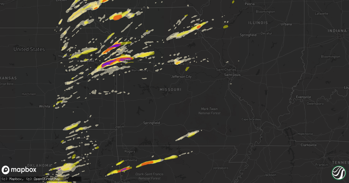
Hail Map in Missouri on March 6, 2017
Get this storm
March 6 map
$229
one time, instant access
Download today. No call, no setup
Keep the $229
Bought the map and want the full workflow? Apply the entire $229 to a subscription within 7 days. None of it is wasted.
Every map, not just this one
This buys you this map. Subscription and you get every map we run, in the markets you choose from a few cities to whole states to nationwide. Plus real-time alerts the moment a storm fires.
Contact data
Name, contact info, occupancy, even credit band for addresses in the footprint. You go from where it hit to who to call.
Become the source they trust
Unlimited branding weather history reports on demand. You already have the documented answer ready for the property owner, and you are the one who showed up with it.
Property data and RoofTrace estimates
Pull up any address you have got, its value and the exact code rules for that jurisdiction, straight from One Click Code. Then RoofTrace estimates the squares, pitch, and roof value, priced the way you price.
Storm reports in Missouri
Missouri
| Date | Description |
|---|---|
| 03/06/20175:55 PM CST | Up to golf ball... Saw a lot of quarter size as well. Hail is covering the roads. |
| 03/06/20175:55 PM CST | Em relayed report from spotter of ping pong ball size hail in ravenwood . |
| 03/06/20175:52 PM CST | Delayed report. Damage to vinyl siding on west side of home. Time matched to radar. |
| 03/06/20175:51 PM CST | Em relayed report from citizen of shed blown into road on 220th street near ravenwood. |
| 03/06/20175:48 PM CST | . |
| 03/06/20175:42 PM CST | Pickering fire reported quarter size hail on hwy 71 via em. |
| 03/06/20175:36 PM CST | . |
| 03/06/20175:35 PM CST | Law enforcement relayed report from the public of a brief tornado west of maryville. |
| 03/06/20175:34 PM CST | Dispatch relayed report of 1 inch size hail approx. 1 mile south of the ia border on us hwy 59. |
| 03/06/20175:31 PM CST | Several trees of large diameter were down across harrisonville. . |
| 03/06/20175:30 PM CST | West nodaway fire reported a brief tornado on hwy 113. |
| 03/06/20175:25 PM CST | Sheriff dept reported trees down between forest city and oregon. |
| 03/06/20175:18 PM CST | Em relayed report from highway patrol of semi truck rolled over on i-29 at mm84. |
| 03/06/20175:18 PM CST | Sheriff dept reported power lines down. |
| 03/06/20175:17 PM CST | Holt county sheriff dept relayed report from mound city fire dept of a brief tornado just west of mound city. |
| 03/06/20174:36 PM CST | . |
| 03/06/20174:34 PM CST | Dispatch relayed report of 1 inch size hail approx. 1 mile south of the ia border on us hwy 59. |
| 03/06/201712:51 AM CST | Tree blown down at intersection of hwy 61 and hwy m. |
| 03/06/201712:50 AM CST | Tree fell and struck a house off of state highway t. |
| 03/06/201712:45 AM CST | Delayed report. Limbs down and minor damage to a mobile home. . |
| 03/06/201712:40 AM CST | Shingles off of roof and 6 to 8 inch limbs broken off of trees. Observed near fairgrounds siding off of houses. Delayed report. |
| 03/06/201712:40 AM CST | Sheet metal roof torn from 4 by 8 foot section of barn roof and a 3 by 6 foot section torn off the front of the barn on the west side. |
| 03/06/201712:40 AM CST | Several trees blown down along highway b north northeast of hillsboro. |
| 03/06/201712:39 AM CST | 3 to 4 homes with trees blown on top of them along reynolds creek road off highway b. In addition... Numerous trees and power lines down in this area. Time estimated fr |
| 03/06/201712:39 AM CST | Ef0 tornado with a track length of 1.2 miles and width of 75 yards. Maximum wind speed of 80 mph. |
| 03/06/201712:36 AM CST | Power lines down on hwy 30 near cedar hill. |
| 03/06/201712:35 AM CST | 4 or 5 homes with trees downed on top of them along wohlbold road off ems road. Also... Numerous trees and power lines downed in the area. Time estimated from radar. |
| 03/06/201712:34 AM CST | Damage path included uprooted 100-year old oak trees... Extending from about a half mile east of highway 30 along ridge road to near lake adelle. Time estimated from ra |
| 03/06/201712:29 AM CST | Ef0 tornado with a path length of 2.6 miles and width of 80 yards. Maximum wind speed of 85 mph. |
| 03/06/201712:28 AM CST | Large tree limbs and branches down. |
| 03/06/201712:18 AM CST | A local report indicates 63 MPH wind near 4 NNE ORCHARD FARMS |
| 03/06/201712:15 AM CST | Just got 2 reports of large trees down on the ff hwy east of ava city limits. Ava fire department is working on removing tree's on ff hwy. Time estimated based on radar |
| 03/06/201712:05 AM CST | Siding blown off an apartment complex at executive parkway and interstate 70 |
| 03/06/201712:03 AM CST | A local report indicates 60 MPH wind near LAKE ST. LOUIS |
| 03/06/201712:00 AM CST | Building blown over due to damaging winds. |
| 03/05/201711:51 PM CST | *** 3 inj *** ef-1 tornado was surveyed with maximum winds of 100 mph. The tornado was 3 miles long and 100 yards wide. This tornado did damage to a number of homes and |
| 03/05/201711:51 PM CST | Several businesses sustained minor damage on south end of wentzville parkway...south of i-70. |
| 03/05/201711:51 PM CST | *** 3 inj *** a nws storm survey team determined an ef-1 tornado began 3 miles west of wentzville and moved east-northeast into downtown wentzville. The path length was |
| 03/05/201711:51 PM CST | *** 3 inj *** five mobile homes blown over... Another one had a tree fall on it in wentzville near west main street and hilltop drive. Two people trapped at this time. |
| 03/05/201711:49 PM CST | A local report indicates 60 MPH wind near TROY |
| 03/05/201711:40 PM CST | Minor damage to roofing and siding to an apartment complex in rolla. Picture from social media and time was estimated. |
| 03/05/201711:40 PM CST | Reported at national and chestnut... Springfield... Mo.large tree reported on corner of national/chestnut... Storm spotter confirmed tree is down. |
| 03/05/201711:40 PM CST | Residence with tree on roof. |
| 03/05/201711:39 PM CST | Confirmed report of partial roof collapse. Commercial building with unknown occupancy at this time. |
| 03/05/201711:35 PM CST | Several large tree branches were blown down on to highway 160 near walnut shade. |
| 03/05/201711:35 PM CST | Multiple trees down... Some on top of mobile homes. Area will be surveyed by nws. |
| 03/05/201711:33 PM CST | Hwy w... Carports damaged... Mobile home destroyed... One spotter reports it looks like a war zone. |
| 03/05/201711:33 PM CST | Nws survey team determined that an ef1 tornado with 100-110 mph winds damaged a mobile home... Outbuildings and trees from 1 mile southwest of macks creek to 1.5 miles |
| 03/05/201711:27 PM CST | Ef1 tornado surveyed with maximum winds of 100 mph. The tornado was 21 miles long and 150 yards wide. The tornado did mostly tree damage....but did also do some structu |
| 03/05/201711:25 PM CST | Reported at colgate and division... Springfield... Mo. Large tree down with power outage at colgate and division in springfield per ham radio. |
| 03/05/201711:18 PM CST | Minor damage to a metal sign and outbuilding. Picture from social media and time estimated by radar. |
| 03/05/201711:17 PM CST | Reports of a tree several feet thick has fallen on chestnut/ and national and sign on the square has blown down. |
| 03/05/201711:17 PM CST | Confirmed structural damage on cemetery road in macks creek. Waiting for additional reports. |
| 03/05/201711:17 PM CST | A nws storm survey team determined an ef-1 tornado began in rhineland and moved east-northeast across southwest warren county lifting around 2 miles sse of warrenton. T |
| 03/05/201711:15 PM CST | Roof blown off barn. |
| 03/05/201711:15 PM CST | Shingles blown off... Possible gutter damage. Dry-wall dusting within hallways. Submitted via internet. Time based on radar. |
| 03/05/201711:11 PM CST | House structural damage. Unspecified severity. Time estimated. . |
| 03/05/201711:10 PM CST | Structural damage hwy 32. |
| 03/05/201711:10 PM CST | Small tree limbs down... Shingles blown off shed... Anchored objects moved off bases. |
| 03/05/201711:05 PM CST | Measured 62 mph wind gust. |
| 03/05/201711:05 PM CST | Delayed report. Winds overturned a 16 foot diameter pool which had up to 1 foot of water in it. Time estimated from radar. |
| 03/05/201711:04 PM CST | Roof damage. Half of roof blown off a residence. Numerous reports of tree damage within the county. . |
| 03/05/201711:04 PM CST | Large tree down north of pineville on highway w... About 2 south of 76. |
| 03/05/201711:02 PM CST | Reported at bridgewood and m hwy... Nixa... Mo. Half of roof off of house along with fencing down. |
| 03/05/201711:00 PM CST | Several buildings in downtown springfield were damaged with roof blown off. |
| 03/05/201710:51 PM CST | A local report indicates 1.00 inch wind near FULTON |
| 03/05/201710:51 PM CST | 5 ne of fair grove on dallas county line....70 mph gust with some tree damage now 35-40mph sustained. |
| 03/05/201710:50 PM CST | Delayed report. Power pole blown over into tree. |
| 03/05/201710:50 PM CST | Hwy 5 tree landed on house. |
| 03/05/201710:50 PM CST | A piece of roofing and siding blown off at an apartment complex off west bypass and kearney ave. Time was estimated by radar and picture was on social media. |
| 03/05/201710:50 PM CST | Reported at oak knoll road... Rocky mount... Mo part of building on road. |
| 03/05/201710:48 PM CST | Down power line / tree 203 gibbs pierce city. |
| 03/05/201710:43 PM CST | Springfield asos reported wind gusts. |
| 03/05/201710:43 PM CST | Airport sustained damage to aircraft as tie downs rings broke off of aircraft. Damage also to a jet bridge. Part of a metal sign was found on the runway. Exterior ceili |
| 03/05/201710:43 PM CST | 1446 hwy 97 stotts city 2-3 foot diameter tree blown over. |
| 03/05/201710:37 PM CST | Ef0 tornado produced 75-85 mph winds that damaged outbuildings and docks. Max width was 50 yards wide. |
| 03/05/201710:36 PM CST | No damage reported at this time. |
| 03/05/201710:35 PM CST | A local report indicates 60 MPH wind near 3 WNW HANNIBAL |
| 03/05/201710:33 PM CST | Nws survey team determined that an ef1 tornado with 100-110 mph winds damaged a mobile home... Outbuildings and trees from 1 mile southwest of macks creek to 1.5 miles |
| 03/05/201710:32 PM CST | Power poles broken south side of bolivar. |
| 03/05/201710:30 PM CST | Large tree limbs and branches down. |
| 03/05/201710:30 PM CST | Delayed report. Barn destroyed near us highway 160 east of everton. |
| 03/05/201710:30 PM CST | Minor roof damage to home. |
| 03/05/201710:30 PM CST | Numerous large tree branches blown down. There was a report of a wooden fence completely blown down. Several trees were blown down. |
| 03/05/201710:30 PM CST | Parts of strip mall roof blown off into parking lot. Intersection of vandiver and providence |
| 03/05/201710:30 PM CST | Delayed report. Barn blown over. |
| 03/05/201710:25 PM CST | 6 to 12 inch tree limbs down. |
| 03/05/201710:25 PM CST | A local report indicates 1.75 inch wind near LA GRANGE |
| 03/05/201710:20 PM CST | A local report indicates 1.75 inch wind near COLUMBIA |
| 03/05/201710:20 PM CST | 150 foot long metal off of outdoor quail pen damaged by wind gusts on state highway k . Metal became wrapped around tree. |
| 03/05/201710:15 PM CST | Tree blown over onto shed. . |
| 03/05/201710:15 PM CST | Preston area: one home had roof blown off with water damage inside that residence after the storm. Entryway awning ripped off building in town. Billboard sign destroyed |
| 03/05/201710:10 PM CST | Spotter at 16780 hwy 32 close to county line reporting trees down partial roof damage. |
| 03/05/201710:03 PM CST | Via khqa tweet...building damage...trees down in emden. |
| 03/05/201710:03 PM CST | Extensive damage to south county high school |
| 03/05/201710:03 PM CST | A nws storm survey team determined an ef-1 tornado began around 0.75 miles west northwest of argyle and moved east northeast across southern osage county lifting 1 mile |
| 03/05/201710:02 PM CST | Well built barn destroyed near pine road and 210 road just north of alba. Time was estimated by radar. |
| 03/05/201710:01 PM CST | Delayed report. Barn destroyed. |
| 03/05/201710:01 PM CST | 1001 to 1002 pm cst. Ef-1. Estimated peak winds between 90 to 95 mph. Path length of 0.75 miles. Max width 100 yards. End location 37.963707n -93.490202w or 3 miles ssw |
| 03/05/201710:00 PM CST | Phone line poles snapped in half. Stick built garage and pull behind camper destroyed. Home received moderate roof damage with chimney collapsed. |
| 03/05/201710:00 PM CST | Trees down near confluence of sac and osage rivers. |
| 03/05/201710:00 PM CST | Wheatland area damage: a business received moderate roof damage. Home received moderate roof and awning damage. Home north of wheatland on b hwy received shingle damage |
| 03/05/201710:00 PM CST | Trees and power poles down. |
| 03/05/201710:00 PM CST | Large tree blown over onto house |
| 03/05/201710:00 PM CST | Time estimate based on radar. Tree limbs of about 4-5 inches in diameter down in several yards across southern kahoka. |
| 03/05/20179:56 PM CST | Tarp blown off corn stock pile... Minor tree damage... Street signs blown down. |
| 03/05/20179:55 PM CST | Several large barns destroyed along with a storage shed. Large cedar tree damaged. |
| 03/05/20179:55 PM CST | Large limbs down over state route h. Modot had to be called in to remove them. |
| 03/05/20179:55 PM CST | A few broken residential windows... Multiple mailboxes and road signs blown over... A wooden gate completely shattered. |
| 03/05/20179:53 PM CST | Pea to quarters...winds near 45 mph. |
| 03/05/20179:51 PM CST | Reported at joplin airport. |
| 03/05/20179:49 PM CST | *** 1 inj *** ef-1 tornado was surveyed with maximum winds of 100 mph. The tornado was 16 miles long and 150 yards wide. The bulk of the damage was ef-0...primarily to |
| 03/05/20179:45 PM CST | Windows blown out of house and trees down. Possible tornado...damage continues in a straight line from the previous report sw of pilot grove. |
| 03/05/20179:45 PM CST | Trees... Carport... Garage damaged near orleans trail marina on stockton lake. |
| 03/05/20179:40 PM CST | Numerous trees blown down.at least one tree on to a house in el dorado springs. A trailer was toppled over. Several outbuildings and barns destroyed near highway u. Pic |
| 03/05/20179:40 PM CST | A nws storm survey team determined a ef-1 tornado began around 13.4 miles southwest of shelbina and moved northeast lifting 5.5 miles northeast of shelbina. The path le |
| 03/05/20179:40 PM CST | Trees down and grain bin moved. Possible tornado...damage continues in straight line to the intersection of highway 5 and mile corner road. |
| 03/05/20179:35 PM CST | Time estimated based on radar... Hoop barn destroyed... Measured wind gust of 67 mph |
| 03/05/20179:33 PM CST | Kdmo asos reported 50 knots. |
| 03/05/20179:32 PM CST | Em relayed report from county sheriff of tornado south of bevier... Along with 60+ mph winds. |
| 03/05/20179:31 PM CST | A local report indicates 60 MPH wind near MACON |
| 03/05/20179:31 PM CST | Nickel to quarter size hail . |
| 03/05/20179:30 PM CST | A tracker trailer was blown over and blocked 1-49 near the bellamy exit south of nevada. Time was estimated by radar. |
| 03/05/20179:30 PM CST | Trees and power line down on oo highway northeast of warsaw. |
| 03/05/20179:30 PM CST | Time estimated on radar. Roof damage to the hopkins lumber company in memphis. A storm survey determined that damage was caused by a localized downburst with peak winds |
| 03/05/20179:30 PM CST | Power line down across hwy 127. |
| 03/05/20179:30 PM CST | Rv turned over at hwy t and menefee rd. . |
| 03/05/20179:29 PM CST | Delayed report...machine shed flattened |
| 03/05/20179:29 PM CST | Delayed report...damage to a garage |
| 03/05/20179:27 PM CST | Delayed report. Large trees 2 ft in diameter uprooted. Time matched to radar. |
| 03/05/20179:25 PM CST | Kirk asos reported 52 knots. |
| 03/05/20179:25 PM CST | A local report indicates 60 MPH wind near KIRKSVILLE |
| 03/05/20179:24 PM CST | Possible tornado south of nevada at the bellamy exit. Power flashes. Sending deputy to check. |
| 03/05/20179:19 PM CST | Delayed report. Power lines on west side of highway w between se 250 rd and se 300 rd down and blocking roadway. Approximately 10 poles down. Time matched from radar. |
| 03/05/20179:15 PM CST | Power outage. |
| 03/05/20179:15 PM CST | 12 inch diameter bradford pear completely broke. |
| 03/05/20179:14 PM CST | Asos at whiteman afb reported 58 knots. |
| 03/05/20179:10 PM CST | Roof blown off trailer house northwest of nevada. |
| 03/05/20179:08 PM CST | A local report indicates 60 MPH wind near MARCELINE |
| 03/05/20178:57 PM CST | Report from railroad employee of train rocking back and forth... Causing a possible minor train derailment and forcing trains to stop moving in the area. |
| 03/05/20178:57 PM CST | Em relayed report 2x4s across the road... House roof blown off... Power poles snapped. |
| 03/05/20178:55 PM CST | A few broken residential windows... Multiple mailboxes and road signs blown over... A wooden gate completely shattered. |
| 03/05/20178:55 PM CST | Power poles snapped...2 by 4s scattered across the road. |
| 03/05/20178:55 PM CST | Large limbs down over state route h. Modot had to be called in to remove them. |
| 03/05/20178:53 PM CST | Tree fell on mobile home with three people trapped inside. |
| 03/05/20178:52 PM CST | A local report indicates 1.50 inch wind near WAVERLY |
| 03/05/20178:48 PM CST | Debris from a barn over the road at n hwy and chandler rd. . |
| 03/05/20178:46 PM CST | Delayed report. Half dozen barns toppled near highway d. Time matched to radar. |
| 03/05/20178:46 PM CST | Trees and power lines down. |
| 03/05/20178:45 PM CST | Windows blown out of house and trees down. Possible tornado...damage continues in a straight line from the previous report sw of pilot grove. |
| 03/05/20178:43 PM CST | A local report indicates 60 MPH wind near 3 W CENTERVIEW |
| 03/05/20178:40 PM CST | Possible tornado in carrollton. |
| 03/05/20178:40 PM CST | Trees down and grain bin moved. Possible tornado...damage continues in straight line to the intersection of highway 5 and mile corner road. |
| 03/05/20178:40 PM CST | Major damage. 1 power pole fell on a vehicle with people in it. They were rescued and unharmed. There are also power lines over the railroad. |
| 03/05/20178:40 PM CST | Major damage. 1 power pole fell on a vehicle with people in it. They were rescued and unharmed. There are also power lines over the railroad. |
| 03/05/20178:35 PM CST | Fire chief reported quarter size hail. |
| 03/05/20178:35 PM CST | Car port blown into roadway. |
| 03/05/20178:33 PM CST | Kdmo asos reported 50 knots. |
| 03/05/20178:32 PM CST | Em relayed report from county sheriff of tornado south of bevier... Along with 60+ mph winds. |
| 03/05/20178:31 PM CST | Nickel to quarter size hail . |
| 03/05/20178:31 PM CST | A local report indicates 60 MPH wind near MACON |
| 03/05/20178:30 PM CST | Rv turned over at hwy t and menefee rd. . |
| 03/05/20178:30 PM CST | Power line down across hwy 127. |
| 03/05/20178:29 PM CST | Two homes completely destroyed and numerous others damaged...roof off water plant and damages to the power grid. No reported injuries or transports. |
| 03/05/20178:27 PM CST | City em reported car port blown into a roadway. |
| 03/05/20178:27 PM CST | Delayed report. Large trees 2 ft in diameter uprooted. Time matched to radar. |
| 03/05/20178:26 PM CST | . |
| 03/05/20178:26 PM CST | Delayed report via social media. Multiple barns down and trees uprooted. Time matched to radar. |
| 03/05/20178:26 PM CST | . |
| 03/05/20178:25 PM CST | Kirk asos reported 52 knots. |
| 03/05/20178:25 PM CST | A local report indicates 60 MPH wind near KIRKSVILLE |
| 03/05/20178:23 PM CST | Unionville dispatch relayed reports of estimated 70mph winds and 2 funnel clouds in the area per spotters. |
| 03/05/20178:20 PM CST | *** 15 inj *** significant damage to homes in oak grove. No injuries are life threatening. |
| 03/05/20178:19 PM CST | Delayed report. Power lines on west side of highway w between se 250 rd and se 300 rd down and blocking roadway. Approximately 10 poles down. Time matched from radar. |
| 03/05/20178:15 PM CST | 12 inch diameter bradford pear completely broke. |
| 03/05/20178:15 PM CST | Power outage. |
| 03/05/20178:15 PM CST | A local report indicates 1.75 inch wind near 5 WSW BUCKNER |
| 03/05/20178:14 PM CST | Asos at whiteman afb reported 58 knots. |
| 03/05/20178:13 PM CST | Damage to outbuildings. |
| 03/05/20178:12 PM CST | Report of a shed's roof blown onto the road approx. 4 miles north of hwy 136 on route n. |
| 03/05/20178:11 PM CST | Ambulance reported quarter size hail at centerpoint hospital in independence . |
| 03/05/20178:11 PM CST | Relayed report of golf ball size hail at hwy 291 and salisbury rd. |
| 03/05/20178:08 PM CST | Spotter reported 1 inch hail near 23rd st and lees summit rd. |
| 03/05/20178:08 PM CST | A local report indicates 60 MPH wind near MARCELINE |
| 03/05/20178:08 PM CST | Klxt measured 56 knot gust. |
| 03/05/20178:07 PM CST | Quarter size hail reported at hwy 50 and i-470. |
| 03/05/20178:05 PM CST | 6 inch limbs down. |
| 03/05/20178:05 PM CST | Dispatch reported roof blown off house... Along with other damage... Near independence ave and english manor dr. |
| 03/05/20178:05 PM CST | A local report indicates 2.00 inch wind near INDEPENDENCE |
| 03/05/20178:05 PM CST | . |
| 03/05/20178:05 PM CST | 18-20 inch diameter tree knocked over. 6-10 inch diameter branches in the roadway. . |
| 03/05/20178:04 PM CST | . |
| 03/05/20178:03 PM CST | Em relayed report from grundy county fire dept of at least 60 mph winds north of trenton. |
| 03/05/20178:01 PM CST | Golf ball size hail reported at hwy 350 and 63rd st. |
| 03/05/20178:00 PM CST | Power lines down on road. |
| 03/05/20177:59 PM CST | Em relayed report of est. 70mph winds north of jamesport. |
| 03/05/20177:57 PM CST | Damage to trees and minor structural damage. Possible tornado. Grandview pd stated that sb i-49 was closed at 135th st. |
| 03/05/20177:57 PM CST | Em relayed report 2x4s across the road... House roof blown off... Power poles snapped. |
| 03/05/20177:57 PM CST | Report from railroad employee of train rocking back and forth... Causing a possible minor train derailment and forcing trains to stop moving in the area. |
| 03/05/20177:55 PM CST | Power lines and trees down. |
| 03/05/20177:55 PM CST | . |
| 03/05/20177:55 PM CST | Power poles snapped...2 by 4s scattered across the road. |
| 03/05/20177:55 PM CST | . |
| 03/05/20177:55 PM CST | Kgph measured 59 knot gust. |
| 03/05/20177:54 PM CST | Windows blown out of business in westport. |
| 03/05/20177:53 PM CST | Tree fell on mobile home with three people trapped inside. |
| 03/05/20177:52 PM CST | A local report indicates 1.50 inch wind near WAVERLY |
| 03/05/20177:50 PM CST | Damage to the front of a condo building. |
| 03/05/20177:49 PM CST | Tractor trailer overturned due to winds. |
| 03/05/20177:48 PM CST | Debris from a barn over the road at n hwy and chandler rd. . |
| 03/05/20177:46 PM CST | Kc scout reported tractor trailer rollover on sb i-35 at mm 93. |
| 03/05/20177:46 PM CST | Delayed report. Half dozen barns toppled near highway d. Time matched to radar. |
| 03/05/20177:46 PM CST | Trees and power lines down. |
| 03/05/20177:45 PM CST | Tree down the size of a telephone pole. |
| 03/05/20177:43 PM CST | Photo of board driven through stone facade on home...report via social media. |
| 03/05/20177:43 PM CST | Em relayed report from highway patrol of power lines down south of lathrop on mo 33. |
| 03/05/20177:43 PM CST | A local report indicates 60 MPH wind near 3 W CENTERVIEW |
| 03/05/20177:40 PM CST | Major damage. 1 power pole fell on a vehicle with people in it. They were rescued and unharmed. There are also power lines over the railroad. |
| 03/05/20177:40 PM CST | Major damage. 1 power pole fell on a vehicle with people in it. They were rescued and unharmed. There are also power lines over the railroad. |
| 03/05/20177:38 PM CST | Possibly started near hwy cc and hwy 136. Mobile home blow away... Barn damage... And home damage near this area as well. Possible path is through mercer to seymour... |
| 03/05/20177:38 PM CST | Damage to home... Outbuilding and trees. |
| 03/05/20177:36 PM CST | Em relayed report from the public of house damaged at j hwy and mccomas lane. |
| 03/05/20177:35 PM CST | Car port blown into roadway. |
| 03/05/20177:35 PM CST | Fire chief reported quarter size hail. |
| 03/05/20177:32 PM CST | Reported near i-29 and barry rd. |
| 03/05/20177:30 PM CST | Possibly started near hwy cc and hwy 136. Mobile home blow away... Barn damage... And home damage near this area as well. Possible path is through mercer to seymour... |
| 03/05/20177:29 PM CST | Two homes completely destroyed and numerous others damaged...roof off water plant and damages to the power grid. No reported injuries or transports. |
| 03/05/20177:29 PM CST | . |
| 03/05/20177:27 PM CST | Possible tornado damage. 8-12 houses damaged. 4-5 are uninhabitable... The rest have minor damage. . |
| 03/05/20177:27 PM CST | Delayed report. Front porch blown off home. Additional damage to two out buildings. Time matched to radar. |
| 03/05/20177:27 PM CST | Possible tornado damage from just south of trimble to just east of lathrop. Widespread structural... Utility... And vegetation damage ranging from minor to major. Power |
| 03/05/20177:27 PM CST | City em reported car port blown into a roadway. |
| 03/05/20177:27 PM CST | Delayed report. Tractor trailer blown over on i-35 near bethany at mm 93. Time matched to radar. |
| 03/05/20177:26 PM CST | . |
| 03/05/20177:26 PM CST | . |
| 03/05/20177:26 PM CST | Delayed report via social media. Multiple barns down and trees uprooted. Time matched to radar. |
| 03/05/20177:26 PM CST | Spotter measured quarter size hail... Along with power outages in town. |
| 03/05/20177:25 PM CST | . |
| 03/05/20177:24 PM CST | Asos at mci reported 58 knots at 0124z and 0132z. |
| 03/05/20177:23 PM CST | Unionville dispatch relayed reports of estimated 70mph winds and 2 funnel clouds in the area per spotters. |
| 03/05/20177:22 PM CST | Spotter reports a tornado . |
| 03/05/20177:20 PM CST | Northland ares reported estimated 60mph winds... With trailers being moved. Near the smithville hospital. |
| 03/05/20177:20 PM CST | *** 15 inj *** significant damage to homes in oak grove. No injuries are life threatening. |
| 03/05/20177:16 PM CST | Power lines down at nw 70th st and montrose ave. |
| 03/05/20177:16 PM CST | Em reports power lines down at west and 11th st. |
| 03/05/20177:15 PM CST | A local report indicates 1.75 inch wind near 5 WSW BUCKNER |
| 03/05/20177:15 PM CST | A swath of wind around 80 to 90 mph affected areas around and in richmond. A center point irrigation system was toppled over southwest of the city. Inside of richmond s |
| 03/05/20177:13 PM CST | Damage to outbuildings. |
| 03/05/20177:12 PM CST | Report of a shed's roof blown onto the road approx. 4 miles north of hwy 136 on route n. |
| 03/05/20177:11 PM CST | Relayed report of golf ball size hail at hwy 291 and salisbury rd. |
| 03/05/20177:11 PM CST | Ambulance reported quarter size hail at centerpoint hospital in independence . |
| 03/05/20177:08 PM CST | Klxt measured 56 knot gust. |
| 03/05/20177:08 PM CST | Spotter reported 1 inch hail near 23rd st and lees summit rd. |
| 03/05/20177:07 PM CST | Quarter size hail reported at hwy 50 and i-470. |
| 03/05/20177:05 PM CST | A local report indicates 2.00 inch wind near INDEPENDENCE |
| 03/05/20177:05 PM CST | . |
| 03/05/20177:05 PM CST | Dispatch reported roof blown off house... Along with other damage... Near independence ave and english manor dr. |
| 03/05/20177:05 PM CST | 6 inch limbs down. |
| 03/05/20177:05 PM CST | 18-20 inch diameter tree knocked over. 6-10 inch diameter branches in the roadway. . |
| 03/05/20177:04 PM CST | . |
| 03/05/20177:03 PM CST | Em relayed report from grundy county fire dept of at least 60 mph winds north of trenton. |
| 03/05/20177:01 PM CST | Golf ball size hail reported at hwy 350 and 63rd st. |
| 03/05/20177:00 PM CST | Power lines down on road. |
| 03/05/20176:59 PM CST | Em relayed report of est. 70mph winds north of jamesport. |
| 03/05/20176:57 PM CST | Damage to trees and minor structural damage. Possible tornado. Grandview pd stated that sb i-49 was closed at 135th st. |
| 03/05/20176:55 PM CST | Em relayed report from spotter of ping pong ball size hail in ravenwood . |
| 03/05/20176:55 PM CST | . |
| 03/05/20176:55 PM CST | . |
| 03/05/20176:55 PM CST | Kgph measured 59 knot gust. |
| 03/05/20176:55 PM CST | Roof damage to the weston hotel. |
| 03/05/20176:55 PM CST | Up to golf ball... Saw a lot of quarter size as well. Hail is covering the roads. |
| 03/05/20176:54 PM CST | Windows blown out of business in westport. |
| 03/05/20176:52 PM CST | Delayed report. Damage to vinyl siding on west side of home. Time matched to radar. |
| 03/05/20176:51 PM CST | Em relayed report from citizen of shed blown into road on 220th street near ravenwood. |
| 03/05/20176:50 PM CST | Roof damage to the weston hotel. |
| 03/05/20176:49 PM CST | Tractor trailer overturned due to winds. |
| 03/05/20176:48 PM CST | . |
| 03/05/20176:46 PM CST | Kc scout reported tractor trailer rollover on sb i-35 at mm 93. |
| 03/05/20176:45 PM CST | Tree down the size of a telephone pole. |
| 03/05/20176:43 PM CST | Photo of board driven through stone facade on home...report via social media. |
| 03/05/20176:43 PM CST | Em relayed report from highway patrol of power lines down south of lathrop on mo 33. |
| 03/05/20176:42 PM CST | Pickering fire reported quarter size hail on hwy 71 via em. |
| 03/05/20176:38 PM CST | Possibly started near hwy cc and hwy 136. Mobile home blow away... Barn damage... And home damage near this area as well. Possible path is through mercer to seymour... |
| 03/05/20176:38 PM CST | Damage to home... Outbuilding and trees. |
| 03/05/20176:36 PM CST | Em relayed report from the public of house damaged at j hwy and mccomas lane. |
| 03/05/20176:35 PM CST | Law enforcement relayed report from the public of a brief tornado west of maryville. |
| 03/05/20176:32 PM CST | Reported near i-29 and barry rd. |
| 03/05/20176:30 PM CST | West nodaway fire reported a brief tornado on hwy 113. |
| 03/05/20176:30 PM CST | Possibly started near hwy cc and hwy 136. Mobile home blow away... Barn damage... And home damage near this area as well. Possible path is through mercer to seymour... |
| 03/05/20176:29 PM CST | . |
| 03/05/20176:27 PM CST | Possible tornado damage. 8-12 houses damaged. 4-5 are uninhabitable... The rest have minor damage. . |
| 03/05/20176:27 PM CST | Possible tornado damage from just south of trimble to just east of lathrop. Widespread structural... Utility... And vegetation damage ranging from minor to major. Power |
| 03/05/20176:27 PM CST | Delayed report. Front porch blown off home. Additional damage to two out buildings. Time matched to radar. |
| 03/05/20176:27 PM CST | *** 1 inj *** delayed report. Tractor trailer blown over on i-35 near bethany at mm 93. Time matched to radar. |
| 03/05/20176:26 PM CST | Spotter measured quarter size hail... Along with power outages in town. |
| 03/05/20176:25 PM CST | . |
| 03/05/20176:25 PM CST | Sheriff dept reported trees down between forest city and oregon. |
| 03/05/20176:24 PM CST | Asos at mci reported 58 knots at 0124z and 0132z. |
| 03/05/20176:22 PM CST | Spotter reports a tornado . |
| 03/05/20176:20 PM CST | Northland ares reported estimated 60mph winds... With trailers being moved. Near the smithville hospital. |
| 03/05/20176:18 PM CST | Em relayed report from highway patrol of semi truck rolled over on i-29 at mm84. |
| 03/05/20176:18 PM CST | Sheriff dept reported power lines down. |
| 03/05/20176:17 PM CST | Holt county sheriff dept relayed report from mound city fire dept of a brief tornado just west of mound city. |
| 03/05/20176:16 PM CST | Power lines down at nw 70th st and montrose ave. |
| 03/05/20176:16 PM CST | Em reports power lines down at west and 11th st. |
| 03/05/20176:02 PM CST | **delayed report received march 14. Several outbuildings damaged near stanberry from march 6 storms. Time matched with radar. . |
All States Impacted by Hail Map on March 6, 2017
Cities Impacted by Hail Map on March 6, 2017
- Dunbar, NE
- Syracuse, NE
- Talmage, NE
- Stewart, MN
- Buffalo Lake, MN
- Des Moines, IA
- Nowata, OK
- Chelsea, OK
- Blue Mound, KS
- Kiron, IA
- Vail, IA
- Birch Tree, MO
- Mercer, MO
- Lineville, IA
- Rockville, MO
- Schell City, MO
- Coon Rapids, IA
- Pawhuska, OK
- Yutan, NE
- Persia, IA
- Elkhorn, NE
- Neola, IA
- Boys Town, NE
- Bennington, NE
- Blair, NE
- Honey Creek, IA
- Gretna, NE
- Panama, IA
- Ashland, NE
- Waterloo, NE
- Portsmouth, IA
- Crescent, IA
- Earling, IA
- Woodbine, IA
- Fort Calhoun, NE
- Missouri Valley, IA
- Omaha, NE
- Logan, IA
- Springfield, NE
- Papillion, NE
- Valley, NE
- Prairie Grove, AR
- West Fork, AR
- Canehill, AR
- Natural Dam, AR
- Toledo, IA
- Broken Arrow, OK
- Wellsville, KS
- Hartland, MN
- Cylinder, IA
- Mallard, IA
- Frost, MN
- Kiester, MN
- Ledyard, IA
- Lakota, IA
- Ringsted, IA
- Elmore, MN
- Emmetsburg, IA
- Buffalo Center, IA
- Alden, MN
- Lone Rock, IA
- Wells, MN
- Curlew, IA
- Rake, IA
- Freeborn, MN
- Bricelyn, MN
- Fenton, IA
- Swea City, IA
- Bancroft, IA
- Lenexa, KS
- Oak Grove, MO
- De Soto, KS
- Olathe, KS
- Independence, MO
- Mission, KS
- Linwood, KS
- Overbrook, KS
- Prairie Village, KS
- Bonner Springs, KS
- Kansas City, MO
- Grain Valley, MO
- Buckner, MO
- Leawood, KS
- Overland Park, KS
- Napoleon, MO
- Lawrence, KS
- Quenemo, KS
- Levasy, MO
- Ottawa, KS
- Orrick, MO
- Vassar, KS
- Shawnee, KS
- Sibley, MO
- Pomona, KS
- Eudora, KS
- Kansas City, KS
- Baldwin City, KS
- Evansville, AR
- Chester, AR
- Bunch, OK
- Winslow, AR
- Stilwell, OK
- Ridgeway, MO
- Bethany, MO
- Bartlesville, OK
- Bern, KS
- Braymer, MO
- McLouth, KS
- Humboldt, IA
- Dakota City, IA
- Livermore, IA
- Meriden, KS
- Alexandria, MO
- Kahoka, MO
- Saint Patrick, MO
- Richmond, MN
- Paynesville, MN
- Effingham, KS
- Lyndon, KS
- Emerson, IA
- Griswold, IA
- Red Oak, IA
- Elliott, IA
- Laddonia, MO
- Wellsville, MO
- Princeton, MN
- Dalbo, MN
- Cambridge, MN
- Stanchfield, MN
- Westboro, MO
- Riverton, IA
- Tarkio, MO
- Northboro, IA
- Hamburg, IA
- Shenandoah, IA
- Rock Port, MO
- Farragut, IA
- Sidney, IA
- Coin, IA
- Osage City, KS
- La Grange, MO
- Home, KS
- Marysville, KS
- Gentry, MO
- Carson, IA
- Treynor, IA
- Oakland, IA
- Blue Rapids, KS
- Rockwell, IA
- Sheffield, IA
- Swaledale, IA
- Massena, IA
- Cumberland, IA
- Waverly, MO
- Corder, MO
- Norborne, MO
- Carrollton, MO
- Plattsburg, MO
- Stewartsville, MO
- Leavenworth, KS
- Gower, MO
- Platte City, MO
- Trimble, MO
- Oskaloosa, KS
- Smithville, MO
- Edgerton, MO
- Camden Point, MO
- Lathrop, MO
- Dearborn, MO
- Weston, MO
- Easton, KS
- Fort Leavenworth, KS
- Burns, KS
- New Virginia, IA
- Fairmont, MN
- Worth, MO
- Grant City, MO
- Sheridan, MO
- Maryville, MO
- Ravenwood, MO
- Hatfield, MO
- Parnell, MO
- Albany, MO
- Conception Junction, MO
- Denver, MO
- Clyde, MO
- Barnard, MO
- Martinsville, MO
- Stanberry, MO
- Cummings, KS
- Atchison, KS
- Eskridge, KS
- Tabor, IA
- Thurman, IA
- Prague, OK
- Tulsa, OK
- Choctaw, OK
- Bristow, OK
- Mcloud, OK
- Carney, OK
- Seminole, OK
- Okemah, OK
- Earlsboro, OK
- Depew, OK
- Noble, OK
- Sparks, OK
- Harrah, OK
- Tryon, OK
- Davenport, OK
- Bixby, OK
- Tecumseh, OK
- Newalla, OK
- Glenpool, OK
- Agra, OK
- Shawnee, OK
- Boley, OK
- Castle, OK
- Mounds, OK
- Paden, OK
- Meeker, OK
- Chandler, OK
- Norman, OK
- Drumright, OK
- Wellston, OK
- Jenks, OK
- Stroud, OK
- Wewoka, OK
- Cushing, OK
- Kellyville, OK
- Beggs, OK
- Macomb, OK
- Sapulpa, OK
- Mound City, KS
- Pleasanton, KS
- Prescott, KS
- Rich Hill, MO
- Hume, MO
- Hutchinson, MN
- Glencoe, MN
- Brownton, MN
- Foley, MN
- Pierz, MN
- Royalton, MN
- Rice, MN
- Hillman, MN
- Pilot Mound, IA
- Yorktown, IA
- Nodaway, IA
- Essex, IA
- Clarinda, IA
- Villisca, IA
- La Farge, WI
- Farber, MO
- Mountain Home, AR
- Saint Joe, AR
- Yellville, AR
- Norfork, AR
- Flippin, AR
- West Plains, MO
- Mountain View, MO
- Peace Valley, MO
- Pomona, MO
- Monticello, MN
- Big Lake, MN
- Becker, MN
- Harmony, MN
- Newton, IA
- Emmons, MN
- Scarville, IA
- Thompson, IA
- Liberty, MO
- Correctionville, IA
- Cushing, IA
- Oto, IA
- Anthon, IA
- Danbury, IA
- Battle Creek, IA
- Holstein, IA
- La Vista, NE
- Waukee, IA
- West Des Moines, IA
- Cokato, MN
- Silver City, IA
- Rockwell City, IA
- Paxico, KS
- Carroll, IA
- Glidden, IA
- Halbur, IA
- Lake City, IA
- Lidderdale, IA
- Lohrville, IA
- Arcadia, IA
- Lanesboro, IA
- Westside, IA
- Manning, IA
- West Point, IL
- Admire, KS
- Elmer, MO
- Atlanta, MO
- Malta Bend, MO
- Emporia, KS
- Strong City, KS
- Cottonwood Falls, KS
- Belvue, KS
- Nebraska City, NE
- Goldfield, IA
- Hardy, IA
- Eagle Grove, IA
- Thor, IA
- Martinsburg, MO
- Montgomery City, MO
- Columbia, MO
- Foster, MO
- Isanti, MN
- Clare, IA
- Moorland, IA
- Fort Dodge, IA
- Barnum, IA
- New Richland, MN
- Waldorf, MN
- Blue Earth, MN
- Delavan, MN
- Winnebago, MN
- Webster City, IA
- Yates Center, KS
- Saint Marys, KS
- Maple Hill, KS
- Delia, KS
- Princeton, KS
- Alma, KS
- Alta Vista, KS
- Hardin, MO
- Gravity, IA
- Cedar Vale, KS
- Sedan, KS
- Peru, KS
- Elk City, KS
- Cushing, MN
- Creston, IA
- Lenox, IA
- Prescott, IA
- Lenapah, OK
- Wann, OK
- Britt, IA
- Woden, IA
- Summers, AR
- Lincoln, AR
- Westville, OK
- Olsburg, KS
- Redwood Falls, MN
- Morton, MN
- Franklin, MN
- Wabasso, MN
- Olivia, MN
- Clements, MN
- Lamberton, MN
- Morgan, MN
- Pilot Grove, MO
- Bunceton, MO
- Rodney, IA
- Smithland, IA
- Galva, IA
- Valley Falls, KS
- Nortonville, KS
- Hanover, KS
- El Dorado, KS
- Augusta, KS
- Prue, OK
- Cleveland, OK
- Osage, OK
- Duncombe, IA
- Otho, IA
- Lehigh, IA
- Gowrie, IA
- Corning, IA
- Du Bois, NE
- Humboldt, NE
- Pawnee City, NE
- Whiting, KS
- Netawaka, KS
- Muscotah, KS
- Marshall, MO
- Gore, OK
- Vian, OK
- Glasgow, MO
- Beattie, KS
- Burchard, NE
- Waterville, KS
- Summerfield, KS
- Oketo, KS
- Spencer, IA
- Dickens, IA
- Zimmerman, MN
- Lu Verne, IA
- Corwith, IA
- Wesley, IA
- Algona, IA
- Higginsville, MO
- Tecumseh, NE
- Reasnor, IA
- Churdan, IA
- Burnside, IA
- Paton, IA
- Vincent, IA
- Callender, IA
- Farnhamville, IA
- Faribault, MN
- Council Grove, KS
- Harlan, IA
- Defiance, IA
- Dunlap, IA
- Ithaca, NE
- Brock, NE
- Steinauer, NE
- Peru, NE
- Johnson, NE
- Elk Creek, NE
- Auburn, NE
- Hallsville, MO
- Rippey, IA
- Grand Junction, IA
- Matfield Green, KS
- Madison, KS
- Cook, NE
- Jones, OK
- Luther, OK
- Winterset, IA
- Peru, IA
- Junction City, KS
- Independence, KS
- Somers, IA
- Viola, WI
- Readstown, WI
- Viroqua, WI
- Cashton, WI
- Ontario, WI
- Westby, WI
- Sweet Springs, MO
- Hoyt, KS
- Denison, KS
- Mayetta, KS
- Unadilla, NE
- Glenwood, IA
- Malvern, IA
- Pacific Junction, IA
- Norwalk, IA
- Cumming, IA
- Van Meter, IA
- Prole, IA
- Big Cabin, OK
- Holton, KS
- Oronoco, MN
- Rochester, MN
- Crab Orchard, NE
- Neodesha, KS
- Cherryvale, KS
- Quincy, IL
- Ewing, MO
- Canton, MO
- Durham, MO
- Maywood, MO
- Ursa, IL
- Runnells, IA
- Lorimor, IA
- Orient, IA
- Greenfield, IA
- Carlisle, IA
- Prairie City, IA
- Macksburg, IA
- Mitchellville, IA
- Hartford, IA
- Pleasant Hill, IA
- Indianola, IA
- Seneca, KS
- Baileyville, KS
- Frankfort, KS
- Cookson, OK
- Dassel, MN
- Buffalo, MN
- Annandale, MN
- Elk River, MN
- Maple Lake, MN
- Silver Lake, MN
- Clearwater, MN
- Howard Lake, MN
- Clear Lake, MN
- Falls City, NE
- Richmond, MO
- Excelsior Springs, MO
- Rayville, MO
- Kincaid, KS
- Braham, MN
- Salisbury, MO
- Ponca, AR
- Jasper, AR
- Industry, IL
- Chillicothe, MO
- Utica, MO
- Mooresville, MO
- Wamego, KS
- Renwick, IA
- Scranton, IA
- Jefferson, IA
- Manson, IA
- Badger, IA
- Harcourt, IA
- Woolstock, IA
- Dayton, IA
- Wynona, OK
- Hominy, OK
- Barnsdall, OK
- Lewiston, NE
- Ellendale, MN
- Truro, IA
- Danville, AR
- Belleville, AR
- Dardanelle, AR
- Ola, AR
- Percival, IA
- Randolph, IA
- Easton, MN
- Houston, MN
- Mabel, MN
- Spring Grove, MN
- Witter, AR
- Combs, AR
- Maysville, MO
- Brainerd, MN
- Lake City, MN
- Baxter, MN
- Blackwater, MO
- Boonville, MO
- Jamesport, MO
- Gallatin, MO
- Dawson, NE
- Verdon, NE
- Talala, OK
- Avoca, NE
- Otoe, NE
- Claremore, OK
- Virgil, KS
- Hamilton, KS
- Washta, IA
- Dallas Center, IA
- Minburn, IA
- Adel, IA
- Lees Summit, MO
- Raymore, MO
- Ackworth, IA
- Milo, IA
- Stella, NE
- Wathena, KS
- Cosby, MO
- Saint Joseph, MO
- Hamilton, MO
- Cainsville, MO
- Ludlow, MO
- Burr, NE
- Sterling, NE
- Parthenon, AR
- Western Grove, AR
- Harrison, AR
- Kingston, AR
- Hasty, AR
- Van Buren, AR
- Cedarville, AR
- Dana, IA
- Cresco, IA
- Lime Springs, IA
- Pillager, MN
- Palmyra, MO
- Ayrshire, IA
- Graettinger, IA
- Ruthven, IA
- Pattonsburg, MO
- Bucyrus, KS
- Spring Hill, KS
- Dwight, KS
- Rockford, IA
- Mason City, IA
- Shelbyville, MO
- Bethel, MO
- Auxvasse, MO
- Owasso, OK
- Catoosa, OK
- Agency, MO
- Faucett, MO
- Macon, MO
- Alpha, MN
- Jackson, MN
- Fontanelle, IA
- Adair, IA
- Salem, AR
- Moravia, IA
- La Belle, MO
- Council Bluffs, IA
- Clear Lake, IA
- Silex, MO
- Okmulgee, OK
- Wymore, NE
- Blue Springs, NE
- Beatrice, NE
- Cowgill, MO
- Polo, MO
- Lawson, MO
- Exira, IA
- Audubon, IA
- Tonganoxie, KS
- Vendor, AR
- Everton, AR
- Huntsville, AR
- Pindall, AR
- Compton, AR
- Elkins, AR
- Marble Falls, AR
- Scranton, KS
- Carbondale, KS
- Nehawka, NE
- Leon, KS
- Westmoreland, KS
- Manhattan, KS
- Lake Mills, IA
- Riceville, IA
- Weeping Water, NE
- Mineola, IA
- Plattsmouth, NE
- Hastings, IA
- Douglas, NE
- Union, NE
- Murray, NE
- Adams, NE
- Shelby, IA
- Avoca, IA
- Dora, MO
- Zanoni, MO
- Pottersville, MO
- Higbee, MO
- Fayette, MO
- Basehor, KS
- Orchard, IA
- Osage, IA
- Rudd, IA
- Elma, IA
- Floyd, IA
- Marengo, IA
- Watkins, IA
- Bowlus, MN
- Calhoun, MO
- Windsor, MO
- Grinnell, IA
- Kellogg, IA
- Woodward, IA
- Madrid, IA
- Newark, MO
- Princeton, MO
- Ladora, IA
- Victor, IA
- Knierim, IA
- Breda, IA
- Ralston, IA
- Manilla, IA
- Bevier, MO
- Harrisburg, MO
- Lewistown, MO
- Saint Cloud, MN
- Bremen, KS
- Howard, KS
- Gladbrook, IA
- Lincoln, IA
- Reinbeck, IA
- Coweta, OK
- Saint Francis, MN
- Lexington, MO
- Dover, MO
- Grafton, IL
- Harrisonville, MO
- Pleasant Hill, MO
- Bogard, MO
- Mannford, OK
- Houstonia, MO
- Hughesville, MO
- Hamlin, IA
- Neosho Falls, KS
- Westphalia, KS
- Le Roy, KS
- Colony, KS
- Welda, KS
- Clarion, IA
- Galt, IA
- Adair, IL
- Hancock, IA
- Marne, IA
- Walnut, IA
- Oklahoma City, OK
- Americus, KS
- Sand Springs, OK
- Saint George, KS
- Rushville, IL
- Rossville, KS
- Emmett, KS
- Armstrong, IA
- Kingsville, MO
- Centralia, MO
- Olpe, KS
- Yale, OK
- Emden, MO
- Philadelphia, MO
- Avon, MN
- Easton, MO
- Saint Joseph, MN
- Holdingford, MN
- Everest, KS
- Sutter, IL
- Warsaw, IL
- Walnut Grove, MN
- Currie, MN
- Ripley, OK
- Perkins, OK
- Wall Lake, IA
- Auburn, IA
- Lake View, IA
- Kingston, MO
- Cameron, MO
- Rowan, IA
- Earlham, IA
- De Soto, IA
- Owatonna, MN
- Rushville, MO
- Waterloo, IL
- Valmeyer, IL
- Hawk Point, MO
- Alexander, IA
- Kearney, MO
- Holt, MO
- Julian, NE
- Virginia, NE
- Liberty, NE
- Blanchard, IA
- New Market, IA
- Camp Point, IL
- Clayton, IL
- Liberty, IL
- Waverly, KS
- Melvern, KS
- Cromwell, IA
- Chelsea, IA
- Clarence, MO
- Mendon, IL
- Leonard, MO
- Anabel, MO
- Linden, IA
- Perry, IA
- Dawson, IA
- Browning, IL
- Astoria, IL
- Auburn, KS
- Harveyville, KS
- Sturgeon, MO
- Clark, MO
- Elwood, KS
- Reading, KS
- Burlingame, KS
- Alma, MO
- Fairfax, OK
- Skiatook, OK
- Edgerton, KS
- Decatur, NE
- Knoxville, IA
- Pleasantville, IA
- Maitland, MO
- Rosalia, KS
- Cassoday, KS
- Eureka, KS
- Madill, OK
- Skidmore, MO
- Graham, MO
- Valley Springs, AR
- Granada, MN
- Brayton, IA
- Thompson, MO
- New Franklin, MO
- Rocheport, MO
- Mexico, MO
- Ramona, OK
- Ochelata, OK
- Mendon, MO
- Rantoul, KS
- Osawatomie, KS
- Milaca, MN
- Ogilvie, MN
- Turney, MO
- Bayard, IA
- Bagley, IA
- Thornton, IA
- Dougherty, IA
- Trenton, MO
- Deep River, IA
- Montezuma, IA
- Saint Stephen, MN
- Seymour, IA
- Stanton, IA
- Carbon, IA
- Liberty, KS
- Dearing, KS
- Caney, KS
- Coffeyville, KS
- Tyro, KS
- Niotaze, KS
- Copan, OK
- Waldron, MO
- Paola, KS
- Louisburg, KS
- Onaga, KS
- Kimball, MN
- Odell, NE
- Wheeling, MO
- Linneus, MO
- Chula, MO
- Grundy Center, IA
- Aurelia, IA
- Cherokee, IA
- Henrietta, MO
- Altoona, IA
- Macedonia, IA
- Redfield, IA
- Cedar Falls, IA
- Hudson, IA
- Waterloo, IA
- Monticello, MO
- Leland, IA
- Horton, KS
- Topeka, KS
- Grantville, KS
- Dunkerton, IA
- Fairbank, IA
- Miami, MO
- Blackburn, MO
- Calico Rock, AR
- Malcom, IA
- Gibbs, MO
- La Plata, MO
- Edina, MO
- Hurdland, MO
- Novelty, MO
- Brashear, MO
- Baring, MO
- Tupelo, OK
- Coalgate, OK
- Centrahoma, OK
- Durant, OK
- Mead, OK
- Delaware, OK
- Tishomingo, OK
- Fowler, IL
- La Monte, MO
- Knob Noster, MO
- Axtell, KS
- Shubert, NE
- Salem, NE
- Cedar Rapids, IA
- Fairfax, IA
- Marion, IA
- Norway, IA
- Walford, IA
- Washington, OK
- Augusta, IL
- Bowen, IL
- Henderson, IA
- Hampton, IA
- Dows, IA
- Latimer, IA
- Bosworth, MO
- Trimont, MN
- Panora, IA
- Blairsburg, IA
- Conger, MN
- Albert Lea, MN
- Dow City, IA
- Monroe, IA
- Marceline, MO
- Brooklyn, IA
- Dawn, MO
- Hale, MO
- Tina, MO
- Sumner, MO
- Little Falls, MN
- Wallingford, IA
- Estherville, IA
- Dolliver, IA
- Grimes, IA
- Jennings, OK
- Gardner, KS
- Darwin, MN
- Litchfield, MN
- Spencer, OK
- Lewis, IA
- Amity, MO
- Weatherby, MO
- Coffey, MO
- Burbank, OK
- Afton, IA
- Imogene, IA
- Mystic, IA
- Centerville, IA
- Alta, IA
- Storm Lake, IA
- Bexar, AR
- Dolph, AR
- Fulton, MO
- Stilwell, KS
- Belton, MO
- Greenwood, MO
- Lentner, MO
- Callao, MO
- Montrose, MN
- Sully, IA
- Lynnville, IA
- Waseca, MN
- Milburn, OK
- Wapanucka, OK
- Forest City, IA
- Modale, IA
- Minnesota Lake, MN
- Laurens, IA
- Burt, IA
- Titonka, IA
- Whittemore, IA
- Bridgewater, IA
- Crystal Lake, IA
- Mapleton, KS
- Benton City, MO
- Gorin, MO
- Rutledge, MO
- Terlton, OK
- Williamstown, MO
- Zumbro Falls, MN
- Kidder, MO
- Adair, OK
- Altamont, KS
- Edna, KS
- Bellflower, MO
- Middletown, MO
- Jamaica, IA
- Yale, IA
- Johnston, IA
- Lytton, IA
- Onawa, IA
- Cold Spring, MN
- Sallisaw, OK
- Williamsburg, KS
- La Crosse, WI
- Vermillion, KS
- Centralia, KS
- Lone Jack, MO
- Blue Springs, MO
- Stuart, IA
- Dexter, IA
- Winchester, KS
- New Hampton, MO
- Blythedale, MO
- Conception, MO
- Eagleville, MO
- Freeman, MO
- Glencoe, AR
- Warrensburg, MO
- Camden, MO
- Wellington, MO
- New Century, KS
- Grandview, MO
- Kirkman, IA
- Irwin, IA
- Nelson, MO
- Perry, KS
- Elk Horn, IA
- Atlantic, IA
- Clive, IA
- Urbandale, IA
- Traer, IA
- Allen, KS
- Tecumseh, MO
- Gainesville, MO
- Neosho Rapids, KS
- Weleetka, OK
- Sedalia, MO
- Otterville, MO
- Smithton, MO
- Alta Vista, IA
- New Hampton, IA
- Keosauqua, IA
- Mount Sterling, IA
- Hollenberg, KS
- Mound City, MO
- Fairfax, MO
- Shelbina, MO
- Loraine, IL
- New Cambria, MO
- Bunker Hill, IL
- Saint Charles, IA
- Denison, IA
- Charter Oak, IA
- Oakland, NE
- Silver Lake, KS
- Wyaconda, MO
- Bates City, MO
- Odessa, MO
- Pryor, OK
- Arcadia, OK
- Lexington, OK
- Nisswa, MN
- Amana, IA
- Springville, IA
- Mount Vernon, IA
- Kanawha, IA
- Nora Springs, IA
- Otley, IA
- Pella, IA
- Fayetteville, AR
- Pettigrew, AR
- Waldron, AR
- New Bloomfield, MO
- Beardstown, IL
- Frederick, IL
- Maquon, IL
- London Mills, IL


