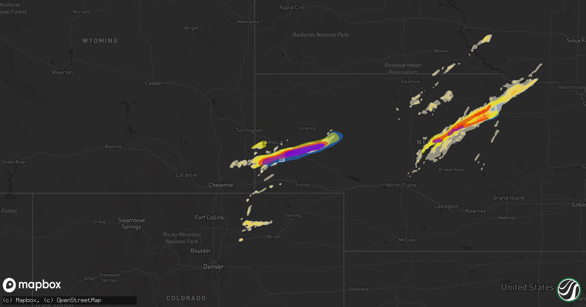
Hail Map on June 22, 2025
Get this storm
June 22 map
$229
one time, instant access
Download today. No call, no setup
Keep the $229
Bought the map and want the full workflow? Apply the entire $229 to a subscription within 7 days. None of it is wasted.
Every map, not just this one
This buys you this map. Subscription and you get every map we run, in the markets you choose from a few cities to whole states to nationwide. Plus real-time alerts the moment a storm fires.
Contact data
Name, contact info, occupancy, even credit band for addresses in the footprint. You go from where it hit to who to call.
Become the source they trust
Unlimited branding weather history reports on demand. You already have the documented answer ready for the property owner, and you are the one who showed up with it.
Property data and RoofTrace estimates
Pull up any address you have got, its value and the exact code rules for that jurisdiction, straight from One Click Code. Then RoofTrace estimates the squares, pitch, and roof value, priced the way you price.
States Impacted by Hail Map on June 22, 2025
Storm reports
Nebraska
| Date | Description |
|---|---|
| 06/22/20256:55 PM CDT | Photos of a snapped power pole and tree damage. |
| 06/22/20256:43 PM CDT | Tower1 upr |
| 06/22/20256:30 PM CDT | Wind-driven hail event with widespread damage across the bridgeport area. Broken windows... Crops stripped... Large trees and power poles downed. |
| 06/22/20256:30 PM CDT | A local report indicates 2.25 inch wind near 1 N Bridgeport |
| 06/22/20256:30 PM CDT | Estimated 60 to 70 mph winds. |
| 06/22/20256:25 PM CDT | R |
| 06/22/20256:25 PM CDT | Report from icechip. |
| 06/22/20256:19 PM CDT | A local report indicates 3.00 inch wind near 4 S Bayard |
| 06/22/20256:18 PM CDT | Report from icechip. |
| 06/22/20256:05 PM CDT | Estimated wind gusts 60 to 70 mph. |
| 06/22/20255:44 PM CDT | A local report indicates 2.00 inch wind near 1 NNE Harrisburg |
| 06/22/20255:42 PM CDT | Photos sent in slack of home with windows broken... Accumulated hail in yard... Large branches down. Time estimated from radar. |
| 06/22/20255:41 PM CDT | A local report indicates 1.75 inch wind near Harrisburg |
| 06/22/20255:38 PM CDT | Video nw of harrisburg. |
| 06/22/20255:25 PM CDT | 1.25 inches of precip in 40 minutes... Quarter and half dollar size hail... Wind gusts between 35 and 45 mph. |
| 06/21/202510:49 PM CDT | Delayed report via social media of tree damage. Time estimated by radar. |
| 06/21/20257:28 PM CDT | Konl awos. |
| 06/21/20257:17 PM CDT | Resn1 raws. Time estimated by radar. |
Alabama
| Date | Description |
|---|---|
| 06/22/20255:54 PM CDT | A tree was knocked down and blocking the roadway at 1224 antioch road. Time estimated by radar. |
| 06/22/20255:36 PM CDT | Multiple trees down and power lines down in the 3200 area on county road 316. |
| 06/22/20255:13 PM CDT | Downed large tree limbs caused damage to a house on jeff road. Time estimated from radar. |
| 06/22/20254:58 PM CDT | Tree down blocking a couple lanes of traffic at moores mill road and highway 72. |
| 06/22/20254:56 PM CDT | Multiple trees down near county road 316 in trinity. Report and photos from social media. Time estimated from radar. |
| 06/22/20254:47 PM CDT | Large trees downed and uprooted near looney road in athens. Report and photos from social media. |
| 06/22/20254:43 PM CDT | A tree was knocked down blocking the roadway at the intersection of cr 358 and cr 547. Time estimated by radar. |
| 06/22/20253:47 PM CDT | Dale county dispatch reports a tree down on county road 61 near county road 512. |
| 06/22/20253:10 PM CDT | Geneva county dispatch reports a tree down on county road 65 near 5 points. |
| 06/22/20252:06 PM CDT | Tree down along cr 115. Time estimated by radar. |
North Dakota
| Date | Description |
|---|---|
| 06/22/20253:55 PM CDT | Delayed report: hail 1 mile n of hannah. Time estimated via radar. |
| 06/22/20259:40 AM CDT | Tree branches down. |
| 06/22/20259:13 AM CDT | A local report indicates 1.00 inch wind near Aneta |
| 06/22/20258:54 AM CDT | Reports thumb size hail. |
| 06/22/20258:40 AM CDT | A local report indicates 1.00 inch wind near Binford |
Oklahoma
| Date | Description |
|---|---|
| 06/21/20259:30 PM CDT | A local report indicates 58 MPH wind near 11 NE Eva |
| 06/21/20257:15 PM CDT | Corrects previous non-tstm wnd gst report from 3 sse boise city. |
Texas
| Date | Description |
|---|---|
| 06/22/20256:49 PM CDT | Peak downburst wind gust of 59 mph. |
| 06/22/20255:55 PM CDT | Sheriff department reports tree down on fm road 2087. Also... The east texas regional airport in longview |
| 06/21/20258:51 PM CDT | A local report indicates 62 MPH wind near 10 ESE Valley de Oro |
| 06/21/20258:37 PM CDT | A local report indicates 66 MPH wind near 3 SE Dumas |
| 06/21/20258:10 PM CDT | The first gust of 59mph occurred at 810pm cdt... With another 58mph gust at 812pm cdt and the last 59mph gust at 814pm cdt. |
| 06/21/20258:00 PM CDT | Spotter reported dime size hail and 60 mph gusts 2 miles south of channing on hwy 385. |
| 06/21/20257:53 PM CDT | A local report indicates 58 MPH wind near 6 WSW Adrian |
| 06/21/20257:21 PM CDT | Peak downburst wind gust of 60 mph with 2 gusts of 58 mph shortly after. |
South Dakota
| Date | Description |
|---|---|
| 06/22/20258:48 AM CDT | A local report indicates 1.75 inch wind near 4 SE Lemmon |
Wisconsin
| Date | Description |
|---|---|
| 06/22/20253:51 AM CDT | 5 to 10 medium to large poplar trees snapped approximately 4 to 8 feet up... Were across the road. Time estimated from radar. |
New Mexico
| Date | Description |
|---|---|
| 06/22/20256:53 PM CDT | Mesonet station 107 endee 2 sw. |
| 06/22/20256:42 PM CDT | A local report indicates 60 MPH wind near 1 S San Jon |
| 06/22/20256:36 PM CDT | A local report indicates 60 MPH wind near 7 W Nara Visa |
| 06/22/20256:32 PM CDT | Utility poles blown down with arcing powerlines and electric service disrupted for residents. |
| 06/22/20256:08 PM CDT | Lasted until 520 pm or so. |
| 06/22/20255:58 PM CDT | Utility poles blown down with arcing powerlines and electric service disrupted for residents. |
| 06/22/20255:25 PM CDT | Lots of dust kicked up. |
| 06/22/20254:55 PM CDT | Mesonet station newn5 newkirk. |
| 06/22/20254:39 PM CDT | Apache hills. |
| 06/22/20254:39 PM CDT | Cotton road. |
| 06/21/20258:40 PM CDT | Mesonet station tr724 rosw |
| 06/21/20258:40 PM CDT | Mesonet station tr724 roswell no. 1 portable. |
| 06/21/20257:17 PM CDT | Asos station krow roswell air center. |
Illinois
| Date | Description |
|---|---|
| 06/22/202512:15 PM CDT | Corrects previous tornado report from 2 e prentice. Ef-0 tornado with maximum winds of 80 mph. Start time and track were adjusted based on sentinel satellite data. Most |
Minnesota
| Date | Description |
|---|---|
| 06/22/202510:29 AM CDT | Personal wx station measurement. |
| 06/22/20259:00 AM CDT | Tree damage relayed via broadcast media. |
| 06/22/20258:15 AM CDT | Tree damage relayed by broadcast media. |
| 06/22/20258:15 AM CDT | Measured gust at fergus falls airport. |
| 06/22/20258:15 AM CDT | Delayed repot: photos of tree damage in fergus falls. Time estimated via radar. |
| 06/22/20254:25 AM CDT | Report relayed by dispatch. Trees down on house. Time estimated from radar. |
| 06/22/20253:59 AM CDT | Report relayed by dispatch. Trees down on powerlines. Time estimated from radar. |
| 06/22/20253:59 AM CDT | Rep |
| 06/22/20253:59 AM CDT | Report relayed by dispatch. Trees down on powerlines. Time estimated from radar. |
| 06/22/20253:59 AM CDT | Report relayed by dispatch. Trees |
| 06/22/20253:59 AM CDT | Report relayed by dispatch. Trees down on |
| 06/22/20253:55 AM CDT | Report from social media with photo. Large maple tree down across house. |
| 06/22/20253:48 AM CDT | Observer reports multiple trees snapped and twisted near base... Taking down several powerlines. Estimates a path of damage about 30 yards wide. Time estimated from rad |
| 06/22/20253:43 AM CDT | Three medium to small trees snapped near base. Time estimated from radar. |
| 06/22/20253:41 AM CDT | Report relayed by dispatch. Trees down on powerline. Time estimated by radar. |
| 06/22/20253:37 AM CDT | Photos from local broadcast media. Several medium to large spruce trees snapped at base. Time estimated from radar. |
| 06/22/20253:30 AM CDT | Dock flipped and some damage to a pontoon boat. A few trees down as well. |
| 06/22/20253:30 AM CDT | Mature hardwood tree blown down. |
| 06/22/20253:05 AM CDT | Tamarack mndot station. |
| 06/22/20253:00 AM CDT | Mature ash tree blown down. |
| 06/22/20253:00 AM CDT | Mature ash tree blown down. (dl |
| 06/22/20253:00 AM CDT | Numerous large pine trees broken at their mid section. Time estimated from radar. |
| 06/22/20253:00 AM CDT | Several large trees down on driveway with no power. Time estimated from radar. |
| 06/22/20253:00 AM CDT | Several large branches broken off. Observer said damage happened around 3am. |
| 06/22/20252:55 AM CDT | Numerous reports from social media of large trees down around big sandy lake. Time estimated from radar. |
| 06/22/20252:48 AM CDT | County dispatch reported multiple trees down in and just north of the city of mcgregor. Time estimated based on radar. |
| 06/22/20252:45 AM CDT | Waukenabo mndot station. |
| 06/22/20252:45 AM CDT | Three large oak trees blown over. |
| 06/22/20252:39 AM CDT | County dispatch reported multiple trees and powerlines were down in the community of palisade. Time estimated based on radar. |
| 06/22/20252:30 AM CDT | County dispatch reported multiple trees and powerlines reported down in the city of aitkin. Time estimated based on radar. |
| 06/22/20252:30 AM CDT | Report from social media with photos of large oak tree down on house. Observer reports other trees also down on powerlines. |
| 06/22/20252:14 AM CDT | Report via social media with photo. Large oak tree snapped near base. Observer reports other smaller trees down nearby as well. Time estimated from radar. |
| 06/22/20252:01 AM CDT | Large tree down. |
| 06/21/20257:02 PM CDT | A local report indicates 70 MPH wind near 6 WNW Grygla |
Georgia
| Date | Description |
|---|---|
| 06/22/20251:31 PM CDT | Courtesy of uga steam mill mesonet site. |
Cities Impacted by Hail Map on June 22, 2025
- Wilmot, SD
- Woodworth, ND
- Cooperstown, ND
- Bison, SD
- Finley, ND
- Sykeston, ND
- Beardsley, MN
- Peever, SD
- Carrington, ND
- Lodgepole, SD
- Graceville, MN
- Dumont, MN
- Browns Valley, MN
- Hannaford, ND
- Wheaton, MN
- Kensal, ND
- Nashua, MN
- Susquehanna, PA
- Thompson, PA
- Union Dale, PA
- Glenfield, ND
- Sharon, ND
- Lemmon, SD
- Mchenry, ND
- Elbow Lake, MN
- Grace City, ND
- Fergus Falls, MN
- Wendell, MN
- Campbell, MN
- Lakota, ND
- Aneta, ND
- Binford, ND
- Sutton, ND
- Vestal, NY
- Binghamton, NY
- Brackney, PA
- Brocket, ND
- Lawton, ND
- Northwood, ND
- Friendsville, PA
- Hettinger, ND
- Adams, ND
- Jessie, ND
- Selfridge, ND
- New Leipzig, ND
- Fairdale, ND
- Elgin, ND
- Montrose, PA
- Minto, ND
- Brundidge, AL
- Center, ND
- Towner, ND
- Washburn, ND
- Wilton, ND
- Karlsruhe, ND
- Wolford, ND
- Bisbee, ND
- Rugby, ND
- Corona, NM
- York, ND
- Columbia, AL
- Headland, AL
- Chancellor, AL
- Anamoose, ND
- Drake, ND
- Enterprise, AL
- Coffee Springs, AL
- Denhoff, ND
- Mcclusky, ND
- Ebro, FL
- Rocklake, ND
- Carriere, MS
- Newville, AL
- Calvin, ND
- Hannah, ND
- Munich, ND
- Midland City, AL
- College Station, TX
- Leeds, ND
- Maddock, ND
- Langdon, ND
- Santa Rosa, NM
- Dothan, AL
- Poplarville, MS
- Wewahitchka, FL
- Egeland, ND
- Wales, ND
- Oberon, ND
- Roswell, NM
- Cheyenne, WY
- Meriden, WY
- Purdum, NE
- Munford, AL
- Franklinton, LA
- Yoder, WY
- Hawk Springs, WY
- Lyman, NE
- Torrington, WY
- Stapleton, NE
- Dunning, NE
- Rotonda West, FL
- Bristol, FL
- Athens, AL
- Toney, AL
- Albin, WY
- Harvest, AL
- Arnold, NE
- Mitchell, NE
- Morrill, NE
- Harrisburg, NE
- Pine Bluffs, WY
- Cuervo, NM
- Newkirk, NM
- Devils Lake, ND
- Huntsville, AL
- Brewster, NE
- Gering, NE
- Logan, NM
- Tucumcari, NM
- Tallahassee, FL
- Taylor, NE
- Ainsworth, NE
- Conchas Dam, NM
- Bassett, NE
- Burwell, NE
- Bayard, NE
- Semmes, AL
- Mobile, AL
- Nara Visa, NM
- Bridgeport, NE
- Minatare, NE
- Mosquero, NM
- Eight Mile, AL
- Mcgrew, NE
- Angora, NE
- Broadwater, NE
- Atkinson, NE
- Stuart, NE
- San Jon, NM
- Chunchula, AL
- Channing, TX
- Amelia, NE
- Lisco, NE
- Adrian, TX
- Melrose, NM
- Clovis, NM
- Emmet, NE
- Chambers, NE
- Oneill, NE
- Inman, NE
- Springview, NE
- Grygla, MN
- Ellsworth, NE
- Oshkosh, NE
- Gatzke, MN
- Lakeside, NE
- Vega, TX
- Broadview, NM
- Bard, NM
- Hereford, TX
- Hartley, TX
- Dalhart, TX
- Winner, SD
- Bingham, NE
- Verdigre, NE
- Page, NE
- Anselmo, NE
- Colome, SD
- Dallas, SD
- Niobrara, NE
- Lynch, NE
- Ewing, NE
- Burke, SD
- Springfield, SD
- Dumas, TX
- Wildorado, TX
- Masterson, TX
- Amarillo, TX
- Stratford, TX
- Cactus, TX
- Sunray, TX
- Platte, SD
- Tabor, SD
- Kimball, SD
- Tatum, NM
- Valentine, NE
- Goodwell, OK
- Stinnett, TX
- Borger, TX
- Fritch, TX
- Panhandle, TX
- Spearman, TX
- Gruver, TX
- Morse, TX
- Canyon, TX
- Wagner, SD
- Scottsbluff, NE
- White Lake, SD
- Wood Lake, NE
- Avon, SD
- Bushnell, NE
- Loman, MN
- Tyndall, SD
- Scotland, SD
- Briggsdale, CO
- Grover, CO
- Johnstown, NE
- Lesterville, SD
- Roggen, CO
- Kersey, CO
- Kimball, NE
- Dexter, NM
- Orchard, CO
- Gregory, SD
- Long Pine, NE
- Brady, NE
- Weldona, CO
- Maxwell, NE
- Fort Morgan, CO
- Dix, NE
- Newport, NE
- Kabetogama, MN
- Clinton, MN
- Watertown, SD
- Ortonville, MN
- International Falls, MN
- Ranier, MN
- Goodwin, SD
- Jasper, MN
- Garretson, SD
- Labolt, SD
- Revillo, SD
- Milbank, SD
- Hardwick, MN
- Big Stone City, SD
- Bellingham, MN
- Odessa, MN
- Edgerton, MN
- Ord, NE
- Ericson, NE
- Elyria, NE
- Chandler, MN
- Montevideo, MN
- Benson, MN
- Cyrus, MN
- Starbuck, MN
- Watson, MN
- Clarissa, MN
- Bartlett, NE
- Staples, MN
- Browerville, MN
- Motley, MN
- Pillager, MN
- Milan, MN
- Nisswa, MN
- Brainerd, MN
- Pequot Lakes, MN
- North Loup, NE
- Pierz, MN
- Fort Ripley, MN
- Merrifield, MN
- Baxter, MN
- Crosby, MN
- Aitkin, MN
- Ironton, MN
- Deerwood, MN
- Crosslake, MN
- Onamia, MN
- Hillman, MN
- Palisade, MN
- Emily, MN
- Mcgregor, MN
- Isle, MN
- McGrath, MN
- Cromwell, MN
- Tamarack, MN
- Kettle River, MN
- Wright, MN
- Brookston, MN
- Floodwood, MN
- Sawyer, MN
- Jacobson, MN
- Meadowlands, MN
- Barnum, MN
- Cloquet, MN
- Alborn, MN
- Saginaw, MN
- Canyon, MN
- Carlton, MN
- Cotton, MN
- Forbes, MN
- Duluth, MN
- Two Harbors, MN
- Silver Bay, MN
- Donalsonville, GA
- Alvarado, MN
- Oslo, MN
- Argyle, MN
- Stephen, MN
- Grafton, ND
- Drayton, ND
- Warren, MN
- Donaldson, MN
- Kennedy, MN
- Karlstad, MN
- Halma, MN
- Grady, NM
- Boise City, OK
- Keyes, OK
- Texhoma, OK