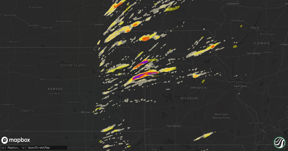
Hail Map on March 6, 2017
Get this storm
March 6 map
$229
one time, instant access
Download today. No call, no setup
Keep the $229
Bought the map and want the full workflow? Apply the entire $229 to a subscription within 7 days. None of it is wasted.
Every map, not just this one
This buys you this map. Subscription and you get every map we run, in the markets you choose from a few cities to whole states to nationwide. Plus real-time alerts the moment a storm fires.
Contact data
Name, contact info, occupancy, even credit band for addresses in the footprint. You go from where it hit to who to call.
Become the source they trust
Unlimited branding weather history reports on demand. You already have the documented answer ready for the property owner, and you are the one who showed up with it.
Property data and RoofTrace estimates
Pull up any address you have got, its value and the exact code rules for that jurisdiction, straight from One Click Code. Then RoofTrace estimates the squares, pitch, and roof value, priced the way you price.
States Impacted by Hail Map on March 6, 2017
Storm reports
Kentucky
| Date | Description |
|---|---|
| 03/06/20174:35 AM CST | Large tree down across patterson ferry rd north of us 68. |
| 03/06/20174:28 AM CST | Large tree down across bryant ford rd south of mcintosh rd. |
| 03/06/20174:21 AM CST | Large tree down across old mayfield rd between krebs station rd and geibe rd. |
| 03/06/20174:15 AM CST | Power outages in brookport. |
| 03/06/20174:07 AM CST | Trees down in the community... And along highway 62 near mayfield creek bridge. Power outages in the slater area. One vehicle damaged. |
| 03/06/20173:52 AM CST | Estimated winds of 75 to 80 mph. 2 garage doors imploded from warehouse and metal roof lifted off. Trees uprooted and other large branches down in through town. Shingle |
| 03/06/20173:50 AM CST | Estimated 75 to 80 mph winds. Soffit damage to store and nearby house. Shingle damage to another house nearby. Roof off barn and debris thrown to the nne. |
| 03/06/20173:50 AM CST | Portion of a warehouse has collapsed roof... And another portion blown away at economy boat store on court street and 1st. Trees and power lines down... And other debri |
Indiana
| Date | Description |
|---|---|
| 03/06/20173:07 AM CST | A few trees were blown down in the georgetown and lake cicott area. One tree was down onto a power line. . |
| 03/06/20172:23 AM CST | Measured at kvpz. |
Nebraska
| Date | Description |
|---|---|
| 03/06/20175:45 PM CST | Pea to quarter size hail. |
| 03/06/20174:59 PM CST | Tin roof blown off sunroom. Near auburn. Via twitter. |
| 03/06/20174:15 PM CST | Avoca fire department reported hail ongoing up to 1 inch. Winds under 50 mph. |
| 03/06/20173:31 PM CST | A local report indicates 1.50 inch wind near FORT CALHOUN |
| 03/06/20173:27 PM CST | A local report indicates 1.50 inch wind near FORT CALHOUN |
| 03/06/20173:20 PM CST | Pea sized hail also reported |
| 03/06/20173:15 PM CST | A local report indicates 1.00 inch wind near 5 E ELKHORN |
| 03/06/20173:15 PM CST | Also half inch hail |
| 03/06/20172:01 PM CST | A local report indicates 1.00 inch wind near OAKLAND |
Oklahoma
| Date | Description |
|---|---|
| 03/06/20172:00 AM CST | Several large tree limbs down |
| 03/06/20171:55 AM CST | Outdoor shed roof damaged |
| 03/06/201712:54 AM CST | Large tree limb down blocking a road |
| 03/06/201712:45 AM CST | A local report indicates 64 MPH wind near 2 SW WILBURTON |
| 03/06/201712:05 AM CST | 3-4 inch diameter limbs down. |
| 03/05/201711:40 PM CST | Damage to church on side side of city from thunderstorm winds. |
| 03/05/201711:20 PM CST | Sheet metal damage to building |
| 03/05/201711:09 PM CST | Tree limbs downed by thunderstorm winds. |
| 03/05/201711:07 PM CST | Roof damage to church |
| 03/05/201710:58 PM CST | Damage to buildings and roof damage from thunderstorm winds. |
| 03/05/201710:51 PM CST | Shingles blown off roof... Siding blown off homes. |
| 03/05/201710:45 PM CST | Housing for boats were damaged on spavinaw lake. 2 housing units were flipped... Several others had roof damage. |
| 03/05/201710:43 PM CST | Tree blown down onto vehicle on peoria avenue. |
| 03/05/201710:42 PM CST | Outbuilding damaged by thunderstorm winds. |
| 03/05/201710:37 PM CST | 5 power poles snapped on memorial just south of 121st. |
| 03/05/201710:35 PM CST | A local report indicates 1.00 inch wind near ADAIR |
| 03/05/201710:28 PM CST | Quarter hail. Hardesty and gordon cooper. |
| 03/05/201710:21 PM CST | A local report indicates 1.00 inch wind near 3 E SAPULPA |
| 03/05/201710:20 PM CST | Few large trees down and mobile home overturned |
| 03/05/201710:20 PM CST | Large tree limb downed. Time estimated via radar. |
| 03/05/201710:16 PM CST | Social media report |
| 03/05/201710:15 PM CST | 5 power poles snapped |
| 03/05/201710:11 PM CST | A local report indicates 1.00 inch wind near 1 NE SHAWNEE |
| 03/05/201710:11 PM CST | A local report indicates 1.25 inch wind near 1 W PRAGUE |
| 03/05/201710:09 PM CST | Nickel and quarter hail. |
| 03/05/201710:00 PM CST | . |
| 03/05/201710:00 PM CST | A local report indicates 60 MPH wind near 7 E CENTRAILIA |
| 03/05/201710:00 PM CST | Relayed via media |
| 03/05/201710:00 PM CST | Several tree limbs down. Flag pole blown down. |
| 03/05/20179:57 PM CST | Trees down and shed overturned with preceding gust front |
| 03/05/20179:55 PM CST | A local report indicates 1.00 inch wind near 4 SSE NORMAN |
| 03/05/20179:55 PM CST | Highway 412 and 209th west avenue |
| 03/05/20179:53 PM CST | Hail reported just north of greasy |
| 03/05/20179:50 PM CST | A local report indicates 1.75 inch wind near 4 S STILWELL |
| 03/05/20179:48 PM CST | Power poles down |
| 03/05/20179:45 PM CST | Ef1. Max winds 90-100 mph. Homes and outbuildings damaged. Trees uprooted and some snapped. |
| 03/05/20179:45 PM CST | A local report indicates 66 MPH wind near 7 E CENTRAILIA |
| 03/05/20179:20 PM CST | Three sections of wooden privacy fence blown down and tree blown over |
| 03/05/20179:15 PM CST | Numerous hail reports relayed. Sent via social media. |
| 03/05/20179:03 PM CST | Dime and quarter hail. |
| 03/05/20178:59 PM CST | A local report indicates 1.00 inch wind near 1 S CARNEY |
| 03/05/20178:25 PM CST | A local report indicates 67 MPH wind near FORAKER |
Arkansas
| Date | Description |
|---|---|
| 03/06/20174:16 AM CST | Large tree down in cabot. |
| 03/06/20174:08 AM CST | A few fences blown over in ward. |
| 03/06/20173:40 AM CST | Spotter estimated 60 mph winds and tree limbs down 3 miles west of vilonia |
| 03/06/20173:35 AM CST | Report of trees down and a roof blown off. |
| 03/06/20173:30 AM CST | Trees down in holland |
| 03/06/20173:25 AM CST | Large cedar tree snapped in half and fell 10 feet away from base of the tree. |
| 03/06/20173:20 AM CST | Several trees were blown down. |
| 03/06/20173:19 AM CST | Power pole was downed in conway |
| 03/06/20172:55 AM CST | A local report indicates 66 MPH wind near WALNUT RIDGE |
| 03/06/20172:55 AM CST | Trees and power lines down along county road 210 and cementary road near black rock. |
| 03/06/20172:55 AM CST | Two trees down with one on a house on faculty drive. No injuries reported. |
| 03/06/20172:45 AM CST | Large tree down hwy 361 and county road 216 south of black rock |
| 03/06/20172:35 AM CST | Many twisted/uprooted trees... Tin rooves peeled off chicken coops. Time estimated based on radar. |
| 03/06/20172:33 AM CST | House is destroyed with many trees and power lines down in st. Joe. |
| 03/06/20172:28 AM CST | Some trees and power lines were blown down. A couple of barns were damaged. |
| 03/06/20171:12 AM CST | 1 tree down across the road nw of pineville. |
| 03/06/20171:05 AM CST | Trees down on highway 309 just south of ozark |
| 03/06/201712:50 AM CST | Roof damage. Privacy fence damage. |
| 03/06/201712:46 AM CST | 2 trees uprooted 4 miles nne of bergman |
| 03/06/201712:40 AM CST | Several trees were uprooted. |
| 03/06/201712:25 AM CST | Trees and power lines were blown down near highway 374 and north tomahawk road. |
| 03/06/201712:23 AM CST | A second home in saint joe has been reported as destroyed by the sheriffs office. |
| 03/06/201712:23 AM CST | Trees were blown down. |
| 03/06/201712:09 AM CST | Trees and power lines were blown down. |
| 03/06/201712:06 AM CST | Trees and power lines were blown down. Multiple trees are down on the road between hasty and carver. |
| 03/06/201712:03 AM CST | Tree damage. Shingle damage. |
| 03/06/201712:00 AM CST | A local report indicates 1.00 inch wind near 5 E JASPER |
| 03/06/201712:00 AM CST | Tree down |
| 03/06/201712:00 AM CST | A few large trees were blown down. |
| 03/05/201711:57 PM CST | Some roofs had shingles blown off of them. Trees were blown down and snapped. |
| 03/05/201711:52 PM CST | Roof blown off of a church |
| 03/05/201711:52 PM CST | Several homes have suffered damage...and the post office has been destroyed. The roof was blown off of a church...and several roadways are blocked. |
| 03/05/201711:48 PM CST | A local report indicates 1.75 inch wind near MT SHERMAN |
| 03/05/201711:38 PM CST | *** 1 inj *** an ef-2 tornado cut a 36.7 mile path across newton and searcy county. Damage included trees being uprooted and snapped. Several residences were damaged. T |
| 03/05/201711:25 PM CST | Small tree down |
| 03/05/201711:18 PM CST | Report of large tree down on nw side of town. |
| 03/05/201711:15 PM CST | Large limbs down |
| 03/05/201711:14 PM CST | Roof blown off house |
| 03/05/201711:12 PM CST | A local report indicates 1.00 inch wind near 3 S WITTER |
| 03/05/201711:01 PM CST | Ef1. Max winds 85-95 mph. Tornado crossed highway 16 northwest of st.paul. Large trees were downed. |
| 03/05/201711:00 PM CST | Large trees down |
| 03/05/201711:00 PM CST | Power lines down on highway 72 |
| 03/05/201711:00 PM CST | Several large trees uprooted. Relayed via nws little rock. |
| 03/05/201710:25 PM CST | Quarter to dime measured. Hail drifts two to four inches deep. |
Illinois
| Date | Description |
|---|---|
| 03/06/201711:53 AM CST | 12-inch tree limb blown down |
| 03/06/20174:15 AM CST | Downed tree limbs and power lines reported. |
| 03/06/20172:53 AM CST | Large limb down |
| 03/06/20172:20 AM CST | Tree down blocking route 119. Report relayed by ema. |
| 03/06/20172:17 AM CST | Shed damaged. Report via twitter |
| 03/06/20172:10 AM CST | Semi blown over at i-57 at mile marker 187. |
| 03/06/20172:05 AM CST | Location- 22271 tobogan road. 3 grain bins and machine shed destroyed. Also... A horse barn received minor damage. |
| 03/06/20172:05 AM CST | Location- intersection of shay and hamann roads. Township building destroyed. |
| 03/06/20171:52 AM CST | Roof partially torn off building. Sign and fence damaged. Power lines down. Reported via wand-tv |
| 03/06/20171:52 AM CST | Small boat overturned. Swop report |
| 03/06/20171:45 AM CST | Tree blown down at redwood street and camp joy road. |
| 03/06/20171:38 AM CST | Grain bin blown off its foundation. Time and location approximate. Received via wand-tv facebook page. |
| 03/06/20171:37 AM CST | Large branches downed across town. |
| 03/06/20171:30 AM CST | A local report indicates 60 MPH wind near MASCOUTAH |
| 03/06/20171:29 AM CST | Large portion of walkway roof at a school damaged. Time estimated per radar. |
| 03/06/20171:27 AM CST | Large tree downed onto a road. Time estimated per radar. |
| 03/06/20171:26 AM CST | Small shed destroyed. Relayed via wics-tv social media |
| 03/06/20171:20 AM CST | Grain bin moved off foundation as well as trees snapped or uprooted |
| 03/06/20171:17 AM CST | At least 3 grain bins moved off their foundations. One was thrown more than 100 yards while another was blown 50 yards. Also... 3 to 4 sheds were unroofed. Time estimat |
| 03/06/20171:14 AM CST | A local report indicates 58 MPH wind near 2 W COAL CITY |
| 03/06/20171:13 AM CST | A local report indicates 63 MPH wind near BOLINGBROOK |
| 03/06/20171:12 AM CST | Highway sign blown down on i-255 |
| 03/06/20171:10 AM CST | A local report indicates 70 MPH wind near SHOREWOOD |
| 03/06/20171:06 AM CST | Large pine tree downed. |
| 03/06/20171:03 AM CST | A couple power poles downed. |
| 03/06/201712:58 AM CST | Several large trees snapped. |
| 03/06/201712:55 AM CST | Large branches snapped. |
| 03/06/201712:55 AM CST | Gust to 59 mph at pnt awos. |
| 03/06/201712:55 AM CST | A local report indicates 59 MPH wind near AURORA |
| 03/06/201712:54 AM CST | A tree downed onto a car. Time estimated per radar and surrounding observations. |
| 03/06/201712:53 AM CST | Extensive tree damage across the area courtesy of facebook pictures. |
| 03/06/201712:52 AM CST | Awning blown off of a business in town. |
| 03/06/201712:45 AM CST | Power poles downed by the high school. Home weather station observed a gust of 73 mph. |
| 03/06/201712:45 AM CST | Shredded roof shingles... Fences... And small trees snapped. Sheet metal torn off barnes in area. |
| 03/06/201712:41 AM CST | Three to four inch diameter tree limbs blown down at rt 23 and rt 64. |
| 03/06/201712:41 AM CST | Quarter size hail at rt 23 and rt 64. |
| 03/06/201712:41 AM CST | Small trees down. Report via twitter |
| 03/06/201712:40 AM CST | A local report indicates 62 MPH wind near SOMONAUK |
| 03/06/201712:36 AM CST | Poles and lines down/bent. Relayed through law enforcement. |
| 03/06/201712:36 AM CST | Large tree downed onto illinois highway 71. Relayed through law enforcement. |
| 03/06/201712:35 AM CST | Delayed report. Picture of snapped tree limbs posted to social media. Damage occurred on the bluffs above piasa bird. |
| 03/06/201712:34 AM CST | In heartland hills subdivision... 12 houses with shingle damage... Several with damaging to fascia on garages. Two fence sections blown over. Stop sign blown down. All |
| 03/06/201712:34 AM CST | Small trailer overturned. Relayed via wics-tv social media |
| 03/06/201712:26 AM CST | Storm siren blown over on pulaski street on southeast side of town. |
| 03/06/201712:23 AM CST | Tree branches broken. Reported via social media |
| 03/06/201712:17 AM CST | Numerous trees down on state route 89 across the county. Time estimated from radar. |
| 03/06/201712:16 AM CST | Multiple power poles broken about half way up at 1300e and 600n. Time estimated from radar |
| 03/06/201712:16 AM CST | Power line down just west of mc nabb on the mc nabb blacktop. Time estimated from radar. |
| 03/06/201712:15 AM CST | A local report indicates 62 MPH wind near TREMONT |
| 03/06/201712:14 AM CST | A local report indicates a tornado near N LADD |
| 03/06/201712:13 AM CST | A local report indicates 62 MPH wind near ROODHOUSE |
| 03/06/201712:12 AM CST | Damage to washington township shed. Wall blown down. |
| 03/06/201712:09 AM CST | Path length 2.8 miles... Width 200 yards. One outbuilding was significantly damaged... With less intense damage to several others. The tornado dissipated 4.1 miles nort |
| 03/06/201712:08 AM CST | On a hog farm... A machine shed was damaged... A corn rib was twisted... But house was not damaged. |
| 03/06/201712:08 AM CST | Two cars from a 108-car train were blown off the tracks between chillicothe and wilbern. Reported by peoria journal-star |
| 03/06/201712:07 AM CST | Delayed report from co-op observer. Time estimated from radar. Top of a large cedar tree and several 2 inch diameter branches from a locust tree down in yard. |
| 03/06/201712:07 AM CST | Time estimated - top of a large cedar tree and several 2 inch branches from a large locust tree blew down in the high wind |
| 03/06/201712:05 AM CST | Part of metal roof peeled back... Just west of logan county border. |
| 03/06/201712:02 AM CST | A local report indicates 63 MPH wind near BELLEVUE |
| 03/06/201712:01 AM CST | 2 story barn destroyed... Cob shed wall blown down... Power lines and power poles down... 4 foot diameter tree snapped. |
| 03/06/201712:01 AM CST | Several power poles down along krause road between cloverdale and spillman roads. Reported by peoria journal-star |
| 03/06/201712:00 AM CST | Path length 7.5 miles... Max width 150 yards. Traveled northeast. It destroyed an outbuilding and a historic single room schoolhouse. It also damaged grain bins... A ba |
| 03/05/201711:58 PM CST | 7 foot privacy fence blown down. Five of the posts were snapped at the base. Relayed via wmbd-tv |
| 03/05/201711:53 PM CST | 12-inch tree limb blown down |
| 03/05/201711:53 PM CST | Irrigation unit flipped near intersection of 1600n and 2800e. |
| 03/05/201711:52 PM CST | Path length 6.9 miles... Peak width 150 yards. Max wind 110 mph. Greatest damage occurred at a farm 2.5 miles north of easton... Where a machine shed was severely damag |
| 03/05/201711:51 PM CST | South wall and half of roof of machine shed blown out. |
| 03/05/201711:50 PM CST | A nws storm survey team determined an ef-1 tornado began on the west side of sawyerville and moved northeast across southwest macoupin county into western montgomery co |
| 03/05/201711:47 PM CST | 12 inch diameter tree limb down. |
| 03/05/201711:43 PM CST | Semi blown over on i-155 at main st. Exit. |
| 03/05/201711:43 PM CST | Tree snapped several feet off the ground. Located in community of monterey. Public report via twitter. |
| 03/05/201711:37 PM CST | Tree blown into a house in matanzas beach. |
| 03/05/201711:37 PM CST | Large object fell on a house. |
| 03/05/201711:34 PM CST | Several trees blown down and damage to a barn. |
| 03/05/201711:34 PM CST | Utility pole blown over |
| 03/05/201711:33 PM CST | 10 power poles snapped at the base near the correctional center. |
| 03/05/201711:28 PM CST | A local report indicates 1.00 inch wind near 7 N FAIRVIEW |
| 03/05/201711:26 PM CST | Pwer pole blown over near intersection of 1200e and 650n |
| 03/05/201711:20 PM CST | A local report indicates 1.00 inch wind near BEARDSTOWN |
| 03/05/201711:20 PM CST | Delayed report. From awos. |
| 03/05/201711:15 PM CST | Time estimated - large tree uprooted by thunderstorm winds |
| 03/05/201711:11 PM CST | Sheet metal blown off building. Swop report |
| 03/05/201711:10 PM CST | A local report indicates 70 MPH wind near NW PRAIRIE CITY |
| 03/05/201711:10 PM CST | 4 to 5 poles down on highway 67 north of 550th street norh of industry. Late report. Time estimated. |
| 03/05/201711:07 PM CST | Car crushed by falling tree near knox college. Reported by galesburg register-mail |
| 03/05/201711:05 PM CST | 3 poles blown down. Late report. Time estimated. |
| 03/05/201711:00 PM CST | Roof damage to house in huntsville |
| 03/05/201711:00 PM CST | Time estimated based on radar. Large tree down on power line in stockton resulted in school cancellation and power outage in lima and stockton. |
| 03/05/201710:41 PM CST | A local report indicates 61 MPH wind near 10 E QUINCY |
| 03/05/201710:41 PM CST | A local report indicates 61 MPH wind near 4 NE BURTON |
| 03/05/201710:40 PM CST | Time estimated on radar. Dead trees blown down |
| 03/05/201710:36 PM CST | Time estimated - lots of small branches down and gutter torn off a home. |
| 03/05/201710:36 PM CST | A local report indicates 58 MPH wind near MOLINE QUAD-CITY AIRPOR |
| 03/05/201710:36 PM CST | Several 8-12 inch branches down in yard. Large aluminum roof of barn across a portion of hwy 336 west of town. |
| 03/05/201710:30 PM CST | A local report indicates 1.00 inch wind near QUINCY |
Minnesota
| Date | Description |
|---|---|
| 03/06/20175:55 PM CST | . |
| 03/06/20175:52 PM CST | Large oak trees fallen and housing pieces wrapped around trees. Possible tornado damage. |
| 03/06/20175:41 PM CST | Trees down... Power lines down... And part of roof missing. |
| 03/06/20175:39 PM CST | Ef1 tornado surveyed in sherburne county. Peak winds 100 to 110 mph. Path length 8.9 miles. |
| 03/06/20175:38 PM CST | Ef1 tornado surveyed in freeborn county. Peak winds 100 to 110 mph. Path length 12.3 miles. |
| 03/06/20175:20 PM CST | . |
| 03/06/20175:20 PM CST | . |
| 03/06/20175:15 PM CST | Car dents also reported. |
| 03/06/20175:10 PM CST | There were hailstones ranging from 1 to 1.5 inches in diameter. |
| 03/06/20175:06 PM CST | . |
| 03/06/20175:05 PM CST | . |
| 03/06/20175:00 PM CST | . |
| 03/06/20174:57 PM CST | . |
| 03/06/20174:56 PM CST | . |
| 03/06/20174:53 PM CST | . |
| 03/06/20174:52 PM CST | . |
| 03/06/20174:45 PM CST | . |
| 03/06/20174:43 PM CST | . |
| 03/06/20174:42 PM CST | . |
| 03/06/20174:41 PM CST | . |
| 03/06/20174:40 PM CST | . |
| 03/06/20174:35 PM CST | . |
| 03/06/20174:34 PM CST | . |
| 03/06/20174:30 PM CST | Late report. |
| 03/06/20174:04 PM CST | Ef1 tornado surveyed in faribault county. Peak winds 90 mph. Path length 9.6 miles. |
| 03/06/20174:00 PM CST | . |
| 03/06/20173:50 PM CST | Reported at county road 65... Between redwood falls and morton... Mn. |
| 03/06/20173:45 PM CST | . |
| 03/06/20173:40 PM CST | . |
| 03/06/20176:25 AM CST | Several trees down with one on a garage. Time estimated from radar. Report via broadcast media twitter. |
| 03/05/20178:33 PM CST | Roof partially blown off a barn. Time estimated from radar. Report via twitter. |
| 03/05/20178:31 PM CST | Several large pine trees snapped. Two outbuildings destroyed with others damaged. Time estimated from radar. Report via facebook. |
| 03/05/20178:12 PM CST | Large tree blown down on a car and partially on a house. Report via facebook. |
| 03/05/20177:30 PM CST | Small branches down. |
| 03/05/20176:43 PM CST | Several utility poles down. Plus numerous 20 inch diameter trees. |
| 03/05/20176:30 PM CST | Reported at 11144 cr 5 nw... Pine island... Mn. Small portion of roof pealed off house on sw corner via eaves. Downed pine tree. . |
| 03/05/20176:28 PM CST | Shed blown across road and took out some power lines. |
| 03/05/20176:26 PM CST | Large trees blown down and pole building roofs damaged. Time estimated by radar. Report via twitter. |
| 03/05/20176:25 PM CST | Trees down across road. |
| 03/05/20176:22 PM CST | Shed roof ripped off. Old garage torn off foundation and demolished. Trees uprooted. |
| 03/05/20176:11 PM CST | Power out in parts of kasson. |
| 03/05/20176:10 PM CST | 8 to 9 inch diameter trees down. |
| 03/05/20176:08 PM CST | Large trees down across road near u.s. Hwy 169. . |
| 03/05/20176:05 PM CST | . |
| 03/05/20176:03 PM CST | Large grain elevator collapsed along with numerous reports of building damage and around town. |
| 03/05/20176:02 PM CST | Homes and businesses damaged. Many trees down with power outage. |
Kansas
| Date | Description |
|---|---|
| 03/06/20175:59 PM CST | This is now part of the weak tornado track that extends from 1 mile west of paxico to this location. |
| 03/06/20175:59 PM CST | Weak ef0 tornado first reported near around i 70 near exit 331. Removed a barn roof on the northeast side of paxico. |
| 03/06/20175:58 PM CST | Tornado reported near around i 70 near exit 331 |
| 03/06/20175:57 PM CST | Em reports 1/2 to quarter size hail on springdale in leavenworth. |
| 03/06/20175:46 PM CST | Video evidence of a weak tornado at this point. No damage reported and no structures impacted. Video evidence supports a track of 1 mile long and 50 yards wide...althou |
| 03/06/20175:46 PM CST | Spin up on the ground reported |
| 03/06/20175:45 PM CST | Sustained winds of 60mph with gusts of 70 mph or greater |
| 03/06/20175:37 PM CST | Visual confirmation of tornado. Tornado caused no known damage. |
| 03/06/20175:36 PM CST | Intermittent tornado tracked from near 3 miles s of st george to 2 miles s of wamego to 3 miles sw of belvue to 2 miles sw of st marys with visible reports of the torna |
| 03/06/20175:35 PM CST | Semi overturned near exit 313 at 177 and i-70. |
| 03/06/20175:35 PM CST | Semi overturned in geary county near exit 313 at 177 and i-70. |
| 03/06/20175:30 PM CST | Delayed report. Wind damage to an outbuilding and a grain bin. |
| 03/06/20175:26 PM CST | Quarter size hail reported by em in manhattan |
| 03/06/20175:13 PM CST | Dime to nickel size hail with isolated quarter size hail. |
| 03/06/20175:06 PM CST | Report of a machine shed destroyed. |
| 03/05/201711:45 PM CST | Golf ball size hail reported on w 71st st near widmer rd. |
| 03/05/201711:08 PM CST | Em reports ping pong size hail at 158th st and kreider rd. |
| 03/05/201710:45 PM CST | Golf ball size hail reported on w 71st st near widmer rd. |
| 03/05/201710:08 PM CST | Em reports ping pong size hail at 158th st and kreider rd. |
| 03/05/20179:34 PM CST | Large tree limb down between 8th and 9th street on washington. Relayed via radio. |
| 03/05/20179:30 PM CST | Wind damage about 6.5 miles east of scammon... Kansas. Multiple power poles snapped along the highway. Time estimated near or before 9:30 this evening. Reported via fac |
| 03/05/20179:27 PM CST | Report of a house partially collapsed along with roof blown off of a machine shed near labette. Also reports of numerous trees down in this location. |
| 03/05/20179:25 PM CST | Tree down blocking roadway. |
| 03/05/20179:13 PM CST | Estimated 70 to 80 mph winds. Via arma pd. No description of damage reported. |
| 03/05/20179:12 PM CST | 146 hwy and 50th ave... In crawford county... Vehicle blown off of roadway... Trees down. |
| 03/05/20179:10 PM CST | Shingles blown off a house. Empty stock tank blown 500 feet. |
| 03/05/20179:10 PM CST | A large tree was blown on to a mobile home. Time was estimated by radar and picture was on social media. |
| 03/05/20179:05 PM CST | A local report indicates 67 MPH wind near COFFEYVILLE |
| 03/05/20179:00 PM CST | Video from a dashcam on social media showed roof blown off a gas station store and other structure nearby. Time was estimated by radar. |
| 03/05/20179:00 PM CST | Hanger destroyed at executive airport. |
| 03/05/20178:59 PM CST | Law enforcement reported 65 mph winds and quarter size hail. |
| 03/05/20178:58 PM CST | A local report indicates 1.00 inch wind near 1 SSE CANEY |
| 03/05/20178:56 PM CST | A local report indicates 65 MPH wind near 4 N DEARING |
| 03/05/20178:54 PM CST | A local report indicates 75 MPH wind near INDEPENDENCE |
| 03/05/20178:50 PM CST | Barn destroyed near indian road and 115th street |
| 03/05/20178:45 PM CST | A local report indicates 60 MPH wind near INDEPENDENCE |
| 03/05/20178:45 PM CST | Via internet submission. No description of damage reported. |
| 03/05/20178:40 PM CST | Siding and shingles off of a few homes. A few have roof damage. Some smaller outbuildings and garages were destroyed. This was throughout central/northern bourbon count |
| 03/05/20178:31 PM CST | A local report indicates 1.00 inch wind near 5 SE SEDAN |
| 03/05/20178:25 PM CST | Building destroyed. |
| 03/05/20178:20 PM CST | Widespread wind damage across northern linn county. Several trees down. Outbuildings flattened. |
| 03/05/20178:17 PM CST | Em reported house damaged with windows blown out near w 2000th rd and cr 1077. |
| 03/05/20178:15 PM CST | Measured 72 mph wind gust at the iola airport. |
| 03/05/20178:15 PM CST | Emergency manager reports that a mobile home was blown off of its foundation and trees were knocked down all in the same direction at a residence. |
| 03/05/20178:15 PM CST | Large trees down. |
| 03/05/20178:08 PM CST | Em relayed report from fire dept of power lines down and power out in parker. |
| 03/05/20178:00 PM CST | Major damage to homes... Including roofs... Walls... And garages. There is also heavy tree damage. |
| 03/05/20178:00 PM CST | Hanger destroyed at executive airport. |
| 03/05/20177:59 PM CST | Roofs blown off multiple homes and barns throughout county. Numerous power lines and power poles down. Several metal buildings destroyed. |
| 03/05/20177:57 PM CST | Half dollar size hail reported at 50th st and state line rd. |
| 03/05/20177:55 PM CST | Spotter reported 60-70mph estimated winds with dime size hail near 18th street and i-70. |
| 03/05/20177:53 PM CST | Em reported power lines down near 261st and pleasant valley road. |
| 03/05/20177:52 PM CST | A local report indicates 70 MPH wind near 8 N YATES CENTER |
| 03/05/20177:51 PM CST | Delayed report. Cement block building destroyed. |
| 03/05/20177:51 PM CST | A local report indicates 70 MPH wind near 1 W GARNETT |
| 03/05/20177:49 PM CST | Spotter reported 1.5 inch hail in merriam. |
| 03/05/20177:48 PM CST | Delayed report. Damage reported to one exterior side of a home. An outbuilding had the tin roof blown off with the west facing wall tilted inward. Two cedar trees 20 in |
| 03/05/20177:48 PM CST | Kojc measured 58 knot gust. |
| 03/05/20177:47 PM CST | 1 inch hail reported near 47th st and monticello rd. |
| 03/05/20177:46 PM CST | Media reports golf ball size hail on the ground 3 miles east of edwardsville on hwy 32. |
| 03/05/20177:46 PM CST | A local report indicates 2.00 inch wind near 2 SW KANSAS CITY KANSAS |
| 03/05/20177:46 PM CST | Delayed report. 2 outbuildings had their tin roofs blown off. |
| 03/05/20177:45 PM CST | Delayed report. Trees down and some uprooted. Time matched to radar. |
| 03/05/20177:45 PM CST | Golf ball size hail reported on w 71st st near widmer rd. |
| 03/05/20177:43 PM CST | Delayed report. 20 power poles down near john brown road and texas road. |
| 03/05/20177:43 PM CST | . |
| 03/05/20177:40 PM CST | Power lines down at 183rd just west of edgerton rd. Reported from a spotter. . |
| 03/05/20177:40 PM CST | Kixd measured 57 knot gust. |
| 03/05/20177:38 PM CST | Em relayed report from spotter of golf ball size hail at k-7 and shawnee mission parkway. |
| 03/05/20177:38 PM CST | Delayed report. Ef-1 tornado with estimated winds of 104mph. Majority of a roof on a home was ripped off. Barn destroyed. Neighbors had video footage of the tornado... |
| 03/05/20177:34 PM CST | A local report indicates 2.00 inch wind near 2 NNE LENEXA |
| 03/05/20177:34 PM CST | . |
| 03/05/20177:30 PM CST | Em reports ping pong size hail at 158th st and kreider rd. |
| 03/05/20177:29 PM CST | Em relayed report from spotter of 1 inch hail near k-7 and shawnee mission parkway. |
| 03/05/20177:29 PM CST | Em relayed report from spotter of golf ball size hail near 111th and k-7. |
| 03/05/20177:29 PM CST | Em reports 1.25 inch hail in de soto. |
| 03/05/20177:27 PM CST | Delayed report. Outbuilding blown over... With some livestock killed. |
| 03/05/20177:25 PM CST | Building destroyed. |
| 03/05/20177:24 PM CST | Delayed report. Tree blown down onto house on rosewood avenue. Time matched to radar. |
| 03/05/20177:23 PM CST | Power pole down. |
| 03/05/20177:22 PM CST | . |
| 03/05/20177:20 PM CST | Widespread wind damage across northern linn county. Several trees down. Outbuildings flattened. |
| 03/05/20177:18 PM CST | Via a social media post |
| 03/05/20177:17 PM CST | Em reported house damaged with windows blown out near w 2000th rd and cr 1077. |
| 03/05/20177:15 PM CST | Large trees down. |
| 03/05/20177:14 PM CST | A local report indicates 59 MPH wind near LAWRENCE |
| 03/05/20177:08 PM CST | Em relayed report from fire dept of power lines down and power out in parker. |
| 03/05/20177:06 PM CST | A local report indicates 1.00 inch wind near 2 SSW PLEASANT GROVE |
| 03/05/20177:05 PM CST | Brief tornado damaged an outbuilding. |
| 03/05/20177:04 PM CST | . |
| 03/05/20177:04 PM CST | A local report indicates 1.00 inch wind near 2 W ROSALIA |
| 03/05/20177:01 PM CST | Em reports golf ball size hail at 207th and springdale road. |
| 03/05/20177:00 PM CST | Major damage to homes... Including roofs... Walls... And garages. There is also heavy tree damage. |
| 03/05/20177:00 PM CST | Hanger destroyed at executive airport. |
| 03/05/20176:59 PM CST | Roofs blown off multiple homes and barns throughout county. Numerous power lines and power poles down. Several metal buildings destroyed. |
| 03/05/20176:57 PM CST | Half dollar size hail reported at 50th st and state line rd. |
| 03/05/20176:57 PM CST | Em reports 1/2 to quarter size hail on springdale in leavenworth. |
| 03/05/20176:56 PM CST | Power poles down and trees down ... South of 24 and phillips road |
| 03/05/20176:55 PM CST | Spotter reported 60-70mph estimated winds with dime size hail near 18th street and i-70. |
| 03/05/20176:53 PM CST | Em reported power lines down near 261st and pleasant valley road. |
| 03/05/20176:53 PM CST | 50 kt wind gust at emporia airport. |
| 03/05/20176:51 PM CST | Estimated 80 mph winds near k 24 and 237 road |
| 03/05/20176:50 PM CST | Delayed report...roof damage to three homes at 151st and quivira |
| 03/05/20176:49 PM CST | Spotter reported 1.5 inch hail in merriam. |
| 03/05/20176:48 PM CST | Kojc measured 58 knot gust. |
| 03/05/20176:47 PM CST | 1 inch hail reported near 47th st and monticello rd. |
| 03/05/20176:46 PM CST | Media reports golf ball size hail on the ground 3 miles east of edwardsville on hwy 32. |
| 03/05/20176:46 PM CST | A local report indicates 2.00 inch wind near 2 SW KANSAS CITY KANSAS |
| 03/05/20176:45 PM CST | Delayed report. Trees down and some uprooted. Time matched to radar. |
| 03/05/20176:45 PM CST | Golf ball size hail reported on w 71st st near widmer rd. |
| 03/05/20176:44 PM CST | Reported at ksnt |
| 03/05/20176:43 PM CST | . |
| 03/05/20176:42 PM CST | Penny size hail along with the wind gust. |
| 03/05/20176:41 PM CST | Roof damage on the west side of el dorado. |
| 03/05/20176:40 PM CST | Damage to residence on south side of el dorado. Screened-in porch torn off. |
| 03/05/20176:40 PM CST | Kixd measured 57 knot gust. |
| 03/05/20176:40 PM CST | Power lines down at 183rd just west of edgerton rd. Reported from a spotter. . |
| 03/05/20176:38 PM CST | Em relayed report from spotter of golf ball size hail at k-7 and shawnee mission parkway. |
| 03/05/20176:37 PM CST | A local report indicates 1.00 inch wind near AMERICUS |
| 03/05/20176:34 PM CST | . |
| 03/05/20176:34 PM CST | A local report indicates 2.00 inch wind near 2 NNE LENEXA |
| 03/05/20176:30 PM CST | Power poles down in cottonwood falls. |
| 03/05/20176:30 PM CST | Em reports ping pong size hail at 158th st and kreider rd. |
| 03/05/20176:29 PM CST | Em reports 1.25 inch hail in de soto. |
| 03/05/20176:29 PM CST | Em relayed report from spotter of golf ball size hail near 111th and k-7. |
| 03/05/20176:29 PM CST | Em relayed report from spotter of 1 inch hail near k-7 and shawnee mission parkway. |
| 03/05/20176:24 PM CST | Delayed report. Tree blown down onto house on rosewood avenue. Time matched to radar. |
| 03/05/20176:23 PM CST | Power pole down. |
| 03/05/20176:22 PM CST | . |
| 03/05/20176:13 PM CST | Weak ef0 tornado flipped over a center pivot irrigation system and proceeded to cause minor tree damage before ending 3 miles ne of silver lake at 621 pm. |
| 03/05/20176:04 PM CST | . |
| 03/05/20176:01 PM CST | Reported at ksnt |
| 03/05/20176:01 PM CST | Em reports golf ball size hail at 207th and springdale road. |
| 03/05/20176:01 PM CST | Video showing tornado on the ground just southwest of st. Mary. |
| 03/05/20176:00 PM CST | This is now part of the intermittent tornado track that extended from 3 miles south of st george to near this location. |
| 03/05/20176:00 PM CST | Delayed report. Roof blown off of a barn. |
Iowa
| Date | Description |
|---|---|
| 03/06/20175:55 PM CST | Semi blown on its side on highway 20 near webster city. Time estimated... Based on radar. |
| 03/06/20175:54 PM CST | Unanchored yard shed and lean to shed destroyed |
| 03/06/20175:50 PM CST | . |
| 03/06/20175:49 PM CST | Dispatch estimated hail up to golf ball size |
| 03/06/20175:42 PM CST | Webster county em reported tree damage and debris in a 1.5 mile long and 30 yard wide damage path. |
| 03/06/20175:33 PM CST | . |
| 03/06/20175:30 PM CST | Spotter reported seeing swirling dust... Damage has been reported in the area. . |
| 03/06/20175:20 PM CST | Reported on social media. . |
| 03/06/20175:19 PM CST | Trees down in red oak cemetery. Time estimated from radar. |
| 03/06/20175:18 PM CST | Dime to quarter sized hail covering the ground. |
| 03/06/20175:15 PM CST | 1 to 1.25 inch hail reported on social media. |
| 03/06/20175:08 PM CST | Cable/telephone pole blown down. Pea and dime size hail also reported |
| 03/06/20175:05 PM CST | Trained spotter reported ongoing quarter sized hail. |
| 03/06/20175:00 PM CST | 2 inch branches blown over. Tin blown off metal buildings. Doors blown off grain elevator. |
| 03/06/20175:00 PM CST | Trained spotter reported lots of quarter sized hail. . |
| 03/06/20174:59 PM CST | Telephone lines down. Pea and dime size hail |
| 03/06/20174:55 PM CST | . |
| 03/06/20174:50 PM CST | Nickel size hail as well. . |
| 03/06/20174:42 PM CST | Public report of golf ball hail from kaal-tv via social media. Time and location estimated by radar. Delayed report. |
| 03/06/20174:40 PM CST | Public reported golf ball sized hail in humboldt. |
| 03/06/20174:40 PM CST | Public report relayed by media on twitter. |
| 03/06/20174:38 PM CST | . |
| 03/06/20174:37 PM CST | . |
| 03/06/20174:35 PM CST | . |
| 03/06/20174:35 PM CST | Pea to quarter sized hail for 5 minutes. Delayed report. . |
| 03/06/20174:30 PM CST | Tree and cable lines down. Pea size hail |
| 03/06/20174:26 PM CST | Pea to dime size hail as well. . |
| 03/06/20174:25 PM CST | Coop observer/trained spotter reported up to quarter sized hail. |
| 03/06/20174:24 PM CST | Spotter reported broken storm windows as well as a few medium to large tree branches down. . |
| 03/06/20174:24 PM CST | Between fort dodge and barnum. |
| 03/06/20174:20 PM CST | Wind driven hail broke window screens at the residence. . |
| 03/06/20174:15 PM CST | Avoca fire department reported hail ongoing up to 1 inch. Winds under 50 mph. |
| 03/06/20174:05 PM CST | Playground equipment blown over in backyard. |
| 03/06/20173:45 PM CST | Hail up to 1 inch just south of beebeetown. Time estimated. |
| 03/06/20173:42 PM CST | A local report indicates 1.00 inch wind near 10 SSE MISSOURI VALLEY |
| 03/06/20173:42 PM CST | A local report indicates 1.00 inch wind near 5 SSE MISSOURI VALLEY |
| 03/06/20173:40 PM CST | On i-29 just south of missouri valley exit. |
| 03/06/20173:35 PM CST | . |
| 03/06/20173:15 PM CST | Report via social media. |
| 03/06/20173:10 PM CST | Pea size hail...public report relayed by media. |
| 03/06/201710:30 AM CST | Large construction trailor just east of the office rolled over and in a ditch due to high winds. |
| 03/05/201710:47 PM CST | Tree down on a house |
| 03/05/201710:45 PM CST | Time estimate. Carport for horses torn down with pieces going into a motor home parked next to it. |
| 03/05/201710:40 PM CST | 1040 to 1045 pm. Ef-1. Estimated peak winds of 110 mph.path length of 4.36 miles. The max width of the tornado was 50 yards. The end location was 2.5 miles southeast of |
| 03/05/201710:32 PM CST | Time estimated - farm buildings damaged and utility poles snapped off near scott county park road and 240th street. |
| 03/05/201710:31 PM CST | Near hwy 30 in dewitt. |
| 03/05/201710:30 PM CST | A local report indicates 64 MPH wind near FORT MADISON MUNICIPAL |
| 03/05/201710:30 PM CST | Time estimated... Tree uprooted on 5th and 11th causing damage to a house |
| 03/05/201710:30 PM CST | A local report indicates 62 MPH wind near KEOKUK AIRPORT |
| 03/05/201710:30 PM CST | Spotter on hwy 30 between grand mound and calumus looking southeast. |
| 03/05/201710:30 PM CST | Three power flashes sequential in 2 seconds. |
| 03/05/201710:30 PM CST | 2 inch diameter branches and shingles blow down with estimated winds of 60 to 65 mph. Time estimated. |
| 03/05/201710:30 PM CST | A local report indicates 65 MPH wind near PARK VIEW |
| 03/05/201710:29 PM CST | A local report indicates 61 MPH wind near DAVENPORT MUNICIPAL AIR |
| 03/05/201710:28 PM CST | Time estimated - several trees down in ridgeview area |
| 03/05/201710:28 PM CST | A local report indicates 83 MPH wind near 6 NW DAVENPORT |
| 03/05/201710:28 PM CST | Debris across i-80. Possible tornado. |
| 03/05/201710:26 PM CST | Large construction trailor just east of the office rolled over and in a ditch due to high winds. |
| 03/05/201710:26 PM CST | A local report indicates 64 MPH wind near FORT MADISON |
| 03/05/201710:25 PM CST | A local report indicates 62 MPH wind near KEOKUK |
| 03/05/201710:24 PM CST | Time estimated - significant damage to commercial property. Several signs and more than a dozen large tow- behind campers damaged |
| 03/05/201710:20 PM CST | Ia dot rwis. |
| 03/05/201710:19 PM CST | 1019 to 1945 pm cst. Ef-2. Estimated peak winds of 115 mph. Path length of 34.7 miles. Max width 200 yards. End location 41.9732 n -90.3501 w or 1 mile east of goose la |
| 03/05/201710:18 PM CST | 1018 pm to 1031 pm. Ef1. Est peak wind 110 mph. Path length 16.7 miles. Max width 100 yards. End location 41.84 n -90.7261 w or 6.5 miles nne wheatland in clinton count |
| 03/05/201710:13 PM CST | 1013 pm to 1036 pm. Ef2. Est peak wind 120 mph. Path length 25.3 miles. Max width 1000 yards. End location 2.9 e long grove or 41.6932 n -90.4995 w. A tornado began in |
| 03/05/201710:12 PM CST | A local report indicates 68 MPH wind near MUSCATINE |
| 03/05/201710:10 PM CST | A local report indicates 68 MPH wind near MUSCATINE MUNICIPAL AIR |
| 03/05/201710:10 PM CST | Damage to car port. |
| 03/05/201710:10 PM CST | Tree damage and power lines down. Tree on roof...near vicinity of shiller and taylor streets...possible tornado. |
| 03/05/201710:09 PM CST | Delayed report. From co-op observer. |
| 03/05/201710:05 PM CST | *** 3 inj *** 1005 pm to 1010 pm. Ef2. Est peak wind 115 mph. Path length 1.8 miles. Max width 200 yards. End location 41.4245 n -91.0456 w. Tornado tracked through mus |
| 03/05/201710:01 PM CST | Trees down...time estimated from radar. |
| 03/05/201710:00 PM CST | Semi tractor trailer blown over on highway 27 north of donnellson near the 1800 block. |
| 03/05/201710:00 PM CST | A local report indicates 60 MPH wind near 2 WNW DUBUQUE |
| 03/05/20179:57 PM CST | At least 6 power poles snapped off just above the ground along highway 92. A semi blown into ditch in the same area. A few trees uprooted and branches down in the vicin |
| 03/05/20179:57 PM CST | 956 pm to 958 pm cst. Ef 2. Estimated peak winds of 115 mph. Path length of 0.3 miles. Max width 150 yards. End location 41.2805 n -91.2567 w in louis county. At least |
| 03/05/20179:51 PM CST | Relayed from a trained spotter in mt. Pleasant |
| 03/05/20179:50 PM CST | Ia dot rwis |
| 03/05/20179:49 PM CST | A local report indicates 70 MPH wind near 1 W MONMOUTH |
| 03/05/20179:48 PM CST | A local report indicates 75 MPH wind near 2 SE IOWA CITY |
| 03/05/20179:47 PM CST | 947 pm to 955 pm cst. Ef0. Peak winds 85 mph. Path length 5.7 miles. Max width 25 yards. End point 5.1 miles ene of bernard in dubuque county. Numerous trees suffered d |
| 03/05/20179:45 PM CST | Pine tree uprooted...machine shed door lost and structure of building shifted off foundation. |
| 03/05/20179:40 PM CST | A local report indicates 66 MPH wind near KALONA |
| 03/05/20179:39 PM CST | A local report indicates 60 MPH wind near IOWA CITY |
| 03/05/20179:39 PM CST | Lost numerous shingles on home in wind gust during middle of storm duration. Kmem radio report. Time estimated from radar. |
| 03/05/20179:36 PM CST | A local report indicates 65 MPH wind near W CASCADE |
| 03/05/20179:35 PM CST | A local report indicates 63 MPH wind near MONTICELLO |
| 03/05/20179:34 PM CST | Ia dot rwis. |
| 03/05/20179:30 PM CST | Time estimated - metal blown off of an outbuilding. |
| 03/05/20179:30 PM CST | A local report indicates 63 MPH wind near MONTICELLO |
| 03/05/20179:25 PM CST | A local report indicates 68 MPH wind near FAIRFIELD |
| 03/05/20179:22 PM CST | A local report indicates 68 MPH wind near FAIRFIELD |
| 03/05/20179:20 PM CST | Ia dot rwis |
| 03/05/20179:20 PM CST | Machine sheds destroyed |
| 03/05/20179:19 PM CST | A local report indicates 70 MPH wind near WELLMAN |
| 03/05/20179:18 PM CST | A local report indicates 69 MPH wind near ONEIDA |
| 03/05/20179:17 PM CST | A local report indicates 70 MPH wind near NORTH LIBERTY |
| 03/05/20179:17 PM CST | A local report indicates 70 MPH wind near 1 S TIFFIN |
| 03/05/20179:15 PM CST | Time estimaed off radar. Siding blown off a new addition to a home. |
| 03/05/20179:10 PM CST | Large pine tree uprooted. . |
| 03/05/20179:10 PM CST | Tree down on highway 78 |
| 03/05/20179:10 PM CST | A local report indicates 1.00 inch wind near 2 NE CEDAR RAPIDS |
| 03/05/20179:10 PM CST | A local report indicates 1.00 inch wind near MARION |
| 03/05/20179:09 PM CST | A local report indicates 73 MPH wind near 1 S EDGEWOOD |
| 03/05/20179:08 PM CST | Trees and power lines down. |
| 03/05/20179:07 PM CST | A local report indicates 73 MPH wind near ELKADER |
| 03/05/20179:06 PM CST | Relayed from trained spotter |
| 03/05/20179:05 PM CST | Relayed from trained spotter |
| 03/05/20179:05 PM CST | A local report indicates 73 MPH wind near 7 S LITTLEPORT |
| 03/05/20179:04 PM CST | . |
| 03/05/20179:04 PM CST | Light post and 12 inch diameter tree blown down. Time estimated from radar. |
| 03/05/20179:04 PM CST | A local report indicates 70 MPH wind near 1 SSE CEDAR RAPIDS |
| 03/05/20179:03 PM CST | A local report indicates 1.00 inch wind near 1 E CEDAR RAPIDS |
| 03/05/20179:02 PM CST | Law enforcement reported several trees down throughout town. Roof off a house on s. Madison ave. Metal shed destroyed on 50th st. Time and report estimated from radar. |
| 03/05/20179:01 PM CST | . |
| 03/05/20179:00 PM CST | A local report indicates 1.00 inch wind near 1 W CEDAR RAPIDS |
| 03/05/20178:58 PM CST | A local report indicates 60 MPH wind near WALKER |
| 03/05/20178:52 PM CST | Shingles blown off house. |
| 03/05/20178:46 PM CST | A local report indicates 79 MPH wind near 3 S INDEPENDENCE |
| 03/05/20178:35 PM CST | A local report indicates 60 MPH wind near 4 W STANLEY |
| 03/05/20178:32 PM CST | Power out 1w of seymour. Very strong winds and heavy rainfall. . |
| 03/05/20178:32 PM CST | Semi and camper flipped over. Power poles snapped off. . |
| 03/05/20178:30 PM CST | Unconfirmed tornado. Report of damage to industrial buildings. Power poles snapped. Semi trucks blown over. . |
| 03/05/20178:30 PM CST | A local report indicates 90 MPH wind near BELLE PLAINE |
| 03/05/20178:30 PM CST | Relayed from a trained spotter |
| 03/05/20178:30 PM CST | A local report indicates 70 MPH wind near KEYSTONE |
| 03/05/20178:27 PM CST | Quarter size hail. |
| 03/05/20178:26 PM CST | Power lines down... House damaged... Barn blown down. . |
| 03/05/20178:26 PM CST | A local report indicates 70 MPH wind near 1 W BELLE PLAINE |
| 03/05/20178:20 PM CST | Multiple dwellings damaged. Extent unknown. . |
| 03/05/20178:20 PM CST | Power out 1w of seymour. Very strong winds and heavy rainfall. . |
| 03/05/20178:00 PM CST | . |
| 03/05/20177:58 PM CST | . |
| 03/05/20177:48 PM CST | 3 open access wooden outbuildings with sheet metal roofing flattened. 7 oak trees felled. Sheet metal strewn across acreage. Time estimated by radar. Delayed report. |
| 03/05/20177:45 PM CST | . |
| 03/05/20177:45 PM CST | Unconfirmed tornado. Significant damage to outbuildings in the area. . |
| 03/05/20177:40 PM CST | Possible tornado - front porch blown off. Windows blown out. Pine trees sheared off the top. Damage toward illinois dr. . |
| 03/05/20177:37 PM CST | Structure damage reported by marion county emergency manager. Report location and time estimated via radar. |
| 03/05/20177:36 PM CST | Nickel hail as well. City of ackworth has no power. . |
| 03/05/20177:33 PM CST | . |
| 03/05/20177:30 PM CST | Trained spotter reports small tornado on the ground seen during lightning. |
| 03/05/20177:25 PM CST | A local report indicates 1.00 inch wind near 5 ESE NEW HAVEN |
| 03/05/20177:25 PM CST | Power poles down and a cattle building damaged near e35 and t19. |
| 03/05/20177:22 PM CST | Possible tornado. Barn destroyed. |
| 03/05/20177:21 PM CST | Power is reported out in in new providence with very strong winds. Also pea to nickel sized hail. Relayed from law enforcement. . |
| 03/05/20177:19 PM CST | Damage to structures on farm. Report delayed. . |
| 03/05/20177:19 PM CST | Barn moved off foundation and heavily damaged. Report delayed. |
| 03/05/20177:18 PM CST | Downed power pole over highway 92 blocking westbound traffic. Time estimated by radar. Straight line winds. . |
| 03/05/20177:18 PM CST | 2 utility poles downed 1/4 mile east of e ave and 1/4 mile south of e avenue. Time estimated by radar. Delayed report. . |
| 03/05/20177:16 PM CST | . |
| 03/05/20177:16 PM CST | Nickel hail as well. City of ackworth has no power. . |
| 03/05/20177:15 PM CST | A local report indicates 1.00 inch wind near 1 W LITTLE CEDAR |
| 03/05/20177:15 PM CST | A local report indicates 1.00 inch wind near RICEVILLE |
| 03/05/20177:12 PM CST | 3 ft. Diameter tree down across 210th st. In the unincorporated town of jordan. Chaser said straight line winds did the damage. . |
| 03/05/20177:11 PM CST | Power lines and trees down. Time estimated by radar. Delayed report. . |
| 03/05/20177:05 PM CST | Emergency manager reported two buildings damaged and a couple of trees blown down. Time estimated by radar. |
| 03/05/20177:05 PM CST | A local report indicates 1.00 inch wind near FLOYD |
| 03/05/20177:03 PM CST | Trees blown across road. Time estimated by radar. Delayed report. |
| 03/05/20177:03 PM CST | Dime size hail. |
| 03/05/20177:01 PM CST | Floyd fd. |
| 03/05/20177:00 PM CST | Minor tree damage. Damage to street signs. |
| 03/05/20176:59 PM CST | Grain bin blown across road. Time estimated by radar. Delayed report. . |
| 03/05/20176:54 PM CST | Power poles leaning due to wind. 1/2 mile north of story-hardin co line on s27. Time estimated by radar. Delayed report. . |
| 03/05/20176:54 PM CST | Unanchored yard shed and lean to shed destroyed |
| 03/05/20176:52 PM CST | Power lines down in many areas of county. |
| 03/05/20176:52 PM CST | A local report indicates 1.00 inch wind near RUDD |
| 03/05/20176:51 PM CST | Nora spring fd. |
| 03/05/20176:49 PM CST | Nora spring fd. |
| 03/05/20176:45 PM CST | 50 to 60 mph wind gusts and pea sized hail. . |
| 03/05/20176:45 PM CST | . |
| 03/05/20176:41 PM CST | Estimated 50-60 mph wind gusts at nws des moines office. . |
| 03/05/20176:40 PM CST | Delayed report. 1-2 ft diameter pine tree across the road. Powerlines down in gilbert. Small tree uprooted... Limb damage. . |
| 03/05/20176:32 PM CST | Nickel to quarter sized hail. |
| 03/05/20176:31 PM CST | Retired nws employee. Few pieces pea size hail and small twigs down. . |
| 03/05/20176:31 PM CST | Relayed from law enforcement. |
| 03/05/20176:26 PM CST | Tree and farm out building damage. Roof sections off building. Time estimated by radar. . |
| 03/05/20176:25 PM CST | Trained spotter reported 0.75 inch diameter hail and estimated 60 mph wind gusts. |
| 03/05/20176:21 PM CST | . |
| 03/05/20176:18 PM CST | Power lines down in town. |
| 03/05/20176:05 PM CST | Damage to machine shed... Greenhouse and trees between rowan and latimer along highway 3. Time estimated by radar. From klmj radio - hampton. . |
| 03/05/20176:00 PM CST | Thunderstorm wind took out power in webster city. Report via social media. |
Wisconsin
| Date | Description |
|---|---|
| 03/06/201712:59 AM CST | Kenosha airport asos. |
| 03/06/201712:45 AM CST | Measured at homestead high school. |
| 03/06/201712:24 AM CST | Trees and power lines down in linn township. More reports of trees and power lines down in central walworth county as well. |
| 03/06/201712:19 AM CST | Tree down on road near township of rubicon. |
| 03/06/201712:15 AM CST | Watertown airport awos. |
| 03/06/201712:05 AM CST | Time of event estimated from weather radar images. Bus driver reported four 2 story tall trees down at residence at intersection of hwy/s a and s. Trees all fell in the |
| 03/05/201711:59 PM CST | Tree down in avon township. |
| 03/05/201711:59 PM CST | Tree down in newark township. |
| 03/05/201711:59 PM CST | Tree down in spring valley township. |
| 03/05/201711:43 PM CST | Home damaged. Horse barn destroyed. Debris strewn over 200 yards. Large pine tree uprooted. Near intersection of highway 14 and cassidy road. Time estimated from radar. |
| 03/05/201711:40 PM CST | Stop light turned due to strong winds. |
| 03/05/201711:39 PM CST | One large tree down in town of middleton. |
| 03/05/201711:25 PM CST | Monroe airport awos. |
| 03/05/201711:00 PM CST | Estimated 60 mph wind sustained for 3-4 mins. From 1055 pm - 1100 pm. Trash carts airborne. A couple of commerical power bumps but no power loss on west side of mt. Hor |
| 03/05/201711:00 PM CST | Trash carts airborne. |
| 03/05/201710:51 PM CST | Power lines down north of la valle. |
| 03/05/201710:36 PM CST | Roof of building on highway g. |
| 03/05/201710:28 PM CST | Sporadic trees reported down across adams county... Including rome... Strongs prairie... And springville townships. Time estimated from radar. . |
| 03/05/201710:12 PM CST | A local report indicates 74 MPH wind near S PLOVER |
| 03/05/20179:56 PM CST | A local report indicates 64 MPH wind near WISCONSIN RAPIDS |
| 03/05/20179:50 PM CST | Trees and power lines down in hillsboro. |
| 03/05/20179:45 PM CST | Trees reported down at various locations in juneau county. Time estimated from radar. . |
| 03/05/20179:45 PM CST | Report via twitter showing wind damage to several structures. Time estimated from radar. |
| 03/05/20179:33 PM CST | Powerlines down west of highway 13. Time estimated from radar. |
| 03/05/20179:32 PM CST | Asos station volk field /vok/. |
| 03/05/20179:30 PM CST | Damage to outbuildings and trees |
| 03/05/20179:25 PM CST | Estimated 50 to 60 mph wind gust. |
| 03/05/20179:25 PM CST | A local report indicates 1.25 inch wind near LA FARGE |
| 03/05/20179:05 PM CST | 6 to 9 inch diameter tree blown down and blocking right east bound lane of interstate 90. |
| 03/05/20179:04 PM CST | Trees... Including several pines... Down in and near viroqua with several power lines down. Time estimated from radar. . |
| 03/05/20179:00 PM CST | A local report indicates 60 MPH wind near 2 W SAINT JOSEPH |
| 03/05/20178:57 PM CST | Fallen trees damaged camper west of viroqua along highway 56. Time/location estimated. . |
| 03/05/20178:50 PM CST | Dozen or so 1-2 ft diameter spruce and white pines uprooted/downed in oak grove cemetary and myrick park. Time approximate. |
| 03/05/20178:46 PM CST | Broken damage path from just north of barre mills to south of west salem. |
| 03/05/20178:45 PM CST | Power lines/outages reported in chaseburg. . |
| 03/05/20178:41 PM CST | Light post and business sign blown down in downtown la crosse. Time estimated from radar. |
| 03/05/20178:40 PM CST | Pea size hail also. |
| 03/05/20178:36 PM CST | Power lines down east of stoddard. |
| 03/05/20178:18 PM CST | Metal grain bin blown over. Time estimated from radar. Report via twitter. |
| 03/05/20177:40 PM CST | Tree reported down south of mondovi along hwy 37. Time estimated from radar. . |
Missouri
| Date | Description |
|---|---|
| 03/06/20175:55 PM CST | Em relayed report from spotter of ping pong ball size hail in ravenwood . |
| 03/06/20175:55 PM CST | Up to golf ball... Saw a lot of quarter size as well. Hail is covering the roads. |
| 03/06/20175:52 PM CST | Delayed report. Damage to vinyl siding on west side of home. Time matched to radar. |
| 03/06/20175:51 PM CST | Em relayed report from citizen of shed blown into road on 220th street near ravenwood. |
| 03/06/20175:48 PM CST | . |
| 03/06/20175:42 PM CST | Pickering fire reported quarter size hail on hwy 71 via em. |
| 03/06/20175:36 PM CST | . |
| 03/06/20175:35 PM CST | Law enforcement relayed report from the public of a brief tornado west of maryville. |
| 03/06/20175:34 PM CST | Dispatch relayed report of 1 inch size hail approx. 1 mile south of the ia border on us hwy 59. |
| 03/06/20175:31 PM CST | Several trees of large diameter were down across harrisonville. . |
| 03/06/20175:30 PM CST | West nodaway fire reported a brief tornado on hwy 113. |
| 03/06/20175:25 PM CST | Sheriff dept reported trees down between forest city and oregon. |
| 03/06/20175:18 PM CST | Sheriff dept reported power lines down. |
| 03/06/20175:18 PM CST | Em relayed report from highway patrol of semi truck rolled over on i-29 at mm84. |
| 03/06/20175:17 PM CST | Holt county sheriff dept relayed report from mound city fire dept of a brief tornado just west of mound city. |
| 03/06/20174:36 PM CST | . |
| 03/06/20174:34 PM CST | Dispatch relayed report of 1 inch size hail approx. 1 mile south of the ia border on us hwy 59. |
| 03/06/201712:51 AM CST | Tree blown down at intersection of hwy 61 and hwy m. |
| 03/06/201712:50 AM CST | Tree fell and struck a house off of state highway t. |
| 03/06/201712:45 AM CST | Delayed report. Limbs down and minor damage to a mobile home. . |
| 03/06/201712:40 AM CST | Sheet metal roof torn from 4 by 8 foot section of barn roof and a 3 by 6 foot section torn off the front of the barn on the west side. |
| 03/06/201712:40 AM CST | Shingles off of roof and 6 to 8 inch limbs broken off of trees. Observed near fairgrounds siding off of houses. Delayed report. |
| 03/06/201712:40 AM CST | Several trees blown down along highway b north northeast of hillsboro. |
| 03/06/201712:39 AM CST | 3 to 4 homes with trees blown on top of them along reynolds creek road off highway b. In addition... Numerous trees and power lines down in this area. Time estimated fr |
| 03/06/201712:39 AM CST | Ef0 tornado with a track length of 1.2 miles and width of 75 yards. Maximum wind speed of 80 mph. |
| 03/06/201712:36 AM CST | Power lines down on hwy 30 near cedar hill. |
| 03/06/201712:35 AM CST | 4 or 5 homes with trees downed on top of them along wohlbold road off ems road. Also... Numerous trees and power lines downed in the area. Time estimated from radar. |
| 03/06/201712:34 AM CST | Damage path included uprooted 100-year old oak trees... Extending from about a half mile east of highway 30 along ridge road to near lake adelle. Time estimated from ra |
| 03/06/201712:29 AM CST | Ef0 tornado with a path length of 2.6 miles and width of 80 yards. Maximum wind speed of 85 mph. |
| 03/06/201712:28 AM CST | Large tree limbs and branches down. |
| 03/06/201712:18 AM CST | A local report indicates 63 MPH wind near 4 NNE ORCHARD FARMS |
| 03/06/201712:15 AM CST | Just got 2 reports of large trees down on the ff hwy east of ava city limits. Ava fire department is working on removing tree's on ff hwy. Time estimated based on radar |
| 03/06/201712:05 AM CST | Siding blown off an apartment complex at executive parkway and interstate 70 |
| 03/06/201712:03 AM CST | A local report indicates 60 MPH wind near LAKE ST. LOUIS |
| 03/06/201712:00 AM CST | Building blown over due to damaging winds. |
| 03/05/201711:51 PM CST | *** 3 inj *** a nws storm survey team determined an ef-1 tornado began 3 miles west of wentzville and moved east-northeast into downtown wentzville. The path length was |
| 03/05/201711:51 PM CST | *** 3 inj *** five mobile homes blown over... Another one had a tree fall on it in wentzville near west main street and hilltop drive. Two people trapped at this time. |
| 03/05/201711:51 PM CST | *** 3 inj *** ef-1 tornado was surveyed with maximum winds of 100 mph. The tornado was 3 miles long and 100 yards wide. This tornado did damage to a number of homes and |
| 03/05/201711:51 PM CST | Several businesses sustained minor damage on south end of wentzville parkway...south of i-70. |
| 03/05/201711:49 PM CST | A local report indicates 60 MPH wind near TROY |
| 03/05/201711:40 PM CST | Reported at national and chestnut... Springfield... Mo.large tree reported on corner of national/chestnut... Storm spotter confirmed tree is down. |
| 03/05/201711:40 PM CST | Residence with tree on roof. |
| 03/05/201711:40 PM CST | Minor damage to roofing and siding to an apartment complex in rolla. Picture from social media and time was estimated. |
| 03/05/201711:39 PM CST | Confirmed report of partial roof collapse. Commercial building with unknown occupancy at this time. |
| 03/05/201711:35 PM CST | Multiple trees down... Some on top of mobile homes. Area will be surveyed by nws. |
| 03/05/201711:35 PM CST | Several large tree branches were blown down on to highway 160 near walnut shade. |
| 03/05/201711:33 PM CST | Nws survey team determined that an ef1 tornado with 100-110 mph winds damaged a mobile home... Outbuildings and trees from 1 mile southwest of macks creek to 1.5 miles |
| 03/05/201711:33 PM CST | Hwy w... Carports damaged... Mobile home destroyed... One spotter reports it looks like a war zone. |
| 03/05/201711:27 PM CST | Ef1 tornado surveyed with maximum winds of 100 mph. The tornado was 21 miles long and 150 yards wide. The tornado did mostly tree damage....but did also do some structu |
| 03/05/201711:25 PM CST | Reported at colgate and division... Springfield... Mo. Large tree down with power outage at colgate and division in springfield per ham radio. |
| 03/05/201711:18 PM CST | Minor damage to a metal sign and outbuilding. Picture from social media and time estimated by radar. |
| 03/05/201711:17 PM CST | Reports of a tree several feet thick has fallen on chestnut/ and national and sign on the square has blown down. |
| 03/05/201711:17 PM CST | Confirmed structural damage on cemetery road in macks creek. Waiting for additional reports. |
| 03/05/201711:17 PM CST | A nws storm survey team determined an ef-1 tornado began in rhineland and moved east-northeast across southwest warren county lifting around 2 miles sse of warrenton. T |
| 03/05/201711:15 PM CST | Shingles blown off... Possible gutter damage. Dry-wall dusting within hallways. Submitted via internet. Time based on radar. |
| 03/05/201711:15 PM CST | Roof blown off barn. |
| 03/05/201711:11 PM CST | House structural damage. Unspecified severity. Time estimated. . |
| 03/05/201711:10 PM CST | Structural damage hwy 32. |
| 03/05/201711:10 PM CST | Small tree limbs down... Shingles blown off shed... Anchored objects moved off bases. |
| 03/05/201711:05 PM CST | Measured 62 mph wind gust. |
| 03/05/201711:05 PM CST | Delayed report. Winds overturned a 16 foot diameter pool which had up to 1 foot of water in it. Time estimated from radar. |
| 03/05/201711:04 PM CST | Large tree down north of pineville on highway w... About 2 south of 76. |
| 03/05/201711:04 PM CST | Roof damage. Half of roof blown off a residence. Numerous reports of tree damage within the county. . |
| 03/05/201711:02 PM CST | Reported at bridgewood and m hwy... Nixa... Mo. Half of roof off of house along with fencing down. |
| 03/05/201711:00 PM CST | Several buildings in downtown springfield were damaged with roof blown off. |
| 03/05/201710:51 PM CST | A local report indicates 1.00 inch wind near FULTON |
| 03/05/201710:51 PM CST | 5 ne of fair grove on dallas county line....70 mph gust with some tree damage now 35-40mph sustained. |
| 03/05/201710:50 PM CST | A piece of roofing and siding blown off at an apartment complex off west bypass and kearney ave. Time was estimated by radar and picture was on social media. |
| 03/05/201710:50 PM CST | Hwy 5 tree landed on house. |
| 03/05/201710:50 PM CST | Reported at oak knoll road... Rocky mount... Mo part of building on road. |
| 03/05/201710:50 PM CST | Delayed report. Power pole blown over into tree. |
| 03/05/201710:48 PM CST | Down power line / tree 203 gibbs pierce city. |
| 03/05/201710:43 PM CST | Airport sustained damage to aircraft as tie downs rings broke off of aircraft. Damage also to a jet bridge. Part of a metal sign was found on the runway. Exterior ceili |
| 03/05/201710:43 PM CST | Springfield asos reported wind gusts. |
| 03/05/201710:43 PM CST | 1446 hwy 97 stotts city 2-3 foot diameter tree blown over. |
| 03/05/201710:37 PM CST | Ef0 tornado produced 75-85 mph winds that damaged outbuildings and docks. Max width was 50 yards wide. |
| 03/05/201710:36 PM CST | No damage reported at this time. |
| 03/05/201710:35 PM CST | A local report indicates 60 MPH wind near 3 WNW HANNIBAL |
| 03/05/201710:33 PM CST | Nws survey team determined that an ef1 tornado with 100-110 mph winds damaged a mobile home... Outbuildings and trees from 1 mile southwest of macks creek to 1.5 miles |
| 03/05/201710:32 PM CST | Power poles broken south side of bolivar. |
| 03/05/201710:30 PM CST | Minor roof damage to home. |
| 03/05/201710:30 PM CST | Delayed report. Barn destroyed near us highway 160 east of everton. |
| 03/05/201710:30 PM CST | Delayed report. Barn blown over. |
| 03/05/201710:30 PM CST | Parts of strip mall roof blown off into parking lot. Intersection of vandiver and providence |
| 03/05/201710:30 PM CST | Numerous large tree branches blown down. There was a report of a wooden fence completely blown down. Several trees were blown down. |
| 03/05/201710:30 PM CST | Large tree limbs and branches down. |
| 03/05/201710:25 PM CST | 6 to 12 inch tree limbs down. |
| 03/05/201710:25 PM CST | A local report indicates 1.75 inch wind near LA GRANGE |
| 03/05/201710:20 PM CST | A local report indicates 1.75 inch wind near COLUMBIA |
| 03/05/201710:20 PM CST | 150 foot long metal off of outdoor quail pen damaged by wind gusts on state highway k . Metal became wrapped around tree. |
| 03/05/201710:15 PM CST | Tree blown over onto shed. . |
| 03/05/201710:15 PM CST | Preston area: one home had roof blown off with water damage inside that residence after the storm. Entryway awning ripped off building in town. Billboard sign destroyed |
| 03/05/201710:10 PM CST | Spotter at 16780 hwy 32 close to county line reporting trees down partial roof damage. |
| 03/05/201710:03 PM CST | Via khqa tweet...building damage...trees down in emden. |
| 03/05/201710:03 PM CST | Extensive damage to south county high school |
| 03/05/201710:03 PM CST | A nws storm survey team determined an ef-1 tornado began around 0.75 miles west northwest of argyle and moved east northeast across southern osage county lifting 1 mile |
| 03/05/201710:02 PM CST | Well built barn destroyed near pine road and 210 road just north of alba. Time was estimated by radar. |
| 03/05/201710:01 PM CST | Delayed report. Barn destroyed. |
| 03/05/201710:01 PM CST | 1001 to 1002 pm cst. Ef-1. Estimated peak winds between 90 to 95 mph. Path length of 0.75 miles. Max width 100 yards. End location 37.963707n -93.490202w or 3 miles ssw |
| 03/05/201710:00 PM CST | Wheatland area damage: a business received moderate roof damage. Home received moderate roof and awning damage. Home north of wheatland on b hwy received shingle damage |
| 03/05/201710:00 PM CST | Trees and power poles down. |
| 03/05/201710:00 PM CST | Large tree blown over onto house |
| 03/05/201710:00 PM CST | Trees down near confluence of sac and osage rivers. |
| 03/05/201710:00 PM CST | Phone line poles snapped in half. Stick built garage and pull behind camper destroyed. Home received moderate roof damage with chimney collapsed. |
| 03/05/201710:00 PM CST | Time estimate based on radar. Tree limbs of about 4-5 inches in diameter down in several yards across southern kahoka. |
| 03/05/20179:56 PM CST | Tarp blown off corn stock pile... Minor tree damage... Street signs blown down. |
| 03/05/20179:55 PM CST | A few broken residential windows... Multiple mailboxes and road signs blown over... A wooden gate completely shattered. |
| 03/05/20179:55 PM CST | Large limbs down over state route h. Modot had to be called in to remove them. |
| 03/05/20179:55 PM CST | Several large barns destroyed along with a storage shed. Large cedar tree damaged. |
| 03/05/20179:53 PM CST | Pea to quarters...winds near 45 mph. |
| 03/05/20179:51 PM CST | Reported at joplin airport. |
| 03/05/20179:49 PM CST | *** 1 inj *** ef-1 tornado was surveyed with maximum winds of 100 mph. The tornado was 16 miles long and 150 yards wide. The bulk of the damage was ef-0...primarily to |
| 03/05/20179:45 PM CST | Trees... Carport... Garage damaged near orleans trail marina on stockton lake. |
| 03/05/20179:45 PM CST | Windows blown out of house and trees down. Possible tornado...damage continues in a straight line from the previous report sw of pilot grove. |
| 03/05/20179:40 PM CST | A nws storm survey team determined a ef-1 tornado began around 13.4 miles southwest of shelbina and moved northeast lifting 5.5 miles northeast of shelbina. The path le |
| 03/05/20179:40 PM CST | Trees down and grain bin moved. Possible tornado...damage continues in straight line to the intersection of highway 5 and mile corner road. |
| 03/05/20179:40 PM CST | Numerous trees blown down.at least one tree on to a house in el dorado springs. A trailer was toppled over. Several outbuildings and barns destroyed near highway u. Pic |
| 03/05/20179:35 PM CST | Time estimated based on radar... Hoop barn destroyed... Measured wind gust of 67 mph |
| 03/05/20179:33 PM CST | Kdmo asos reported 50 knots. |
| 03/05/20179:32 PM CST | Em relayed report from county sheriff of tornado south of bevier... Along with 60+ mph winds. |
| 03/05/20179:31 PM CST | A local report indicates 60 MPH wind near MACON |
| 03/05/20179:31 PM CST | Nickel to quarter size hail . |
| 03/05/20179:30 PM CST | Rv turned over at hwy t and menefee rd. . |
| 03/05/20179:30 PM CST | Time estimated on radar. Roof damage to the hopkins lumber company in memphis. A storm survey determined that damage was caused by a localized downburst with peak winds |
| 03/05/20179:30 PM CST | A tracker trailer was blown over and blocked 1-49 near the bellamy exit south of nevada. Time was estimated by radar. |
| 03/05/20179:30 PM CST | Trees and power line down on oo highway northeast of warsaw. |
| 03/05/20179:30 PM CST | Power line down across hwy 127. |
| 03/05/20179:29 PM CST | Delayed report...damage to a garage |
| 03/05/20179:29 PM CST | Delayed report...machine shed flattened |
| 03/05/20179:27 PM CST | Delayed report. Large trees 2 ft in diameter uprooted. Time matched to radar. |
| 03/05/20179:25 PM CST | A local report indicates 60 MPH wind near KIRKSVILLE |
| 03/05/20179:25 PM CST | Kirk asos reported 52 knots. |
| 03/05/20179:24 PM CST | Possible tornado south of nevada at the bellamy exit. Power flashes. Sending deputy to check. |
| 03/05/20179:19 PM CST | Delayed report. Power lines on west side of highway w between se 250 rd and se 300 rd down and blocking roadway. Approximately 10 poles down. Time matched from radar. |
| 03/05/20179:15 PM CST | Power outage. |
| 03/05/20179:15 PM CST | 12 inch diameter bradford pear completely broke. |
| 03/05/20179:14 PM CST | Asos at whiteman afb reported 58 knots. |
| 03/05/20179:10 PM CST | Roof blown off trailer house northwest of nevada. |
| 03/05/20179:08 PM CST | A local report indicates 60 MPH wind near MARCELINE |
| 03/05/20178:57 PM CST | Em relayed report 2x4s across the road... House roof blown off... Power poles snapped. |
| 03/05/20178:57 PM CST | Report from railroad employee of train rocking back and forth... Causing a possible minor train derailment and forcing trains to stop moving in the area. |
| 03/05/20178:55 PM CST | Power poles snapped...2 by 4s scattered across the road. |
| 03/05/20178:55 PM CST | Large limbs down over state route h. Modot had to be called in to remove them. |
| 03/05/20178:55 PM CST | A few broken residential windows... Multiple mailboxes and road signs blown over... A wooden gate completely shattered. |
| 03/05/20178:53 PM CST | Tree fell on mobile home with three people trapped inside. |
| 03/05/20178:52 PM CST | A local report indicates 1.50 inch wind near WAVERLY |
| 03/05/20178:48 PM CST | Debris from a barn over the road at n hwy and chandler rd. . |
| 03/05/20178:46 PM CST | Trees and power lines down. |
| 03/05/20178:46 PM CST | Delayed report. Half dozen barns toppled near highway d. Time matched to radar. |
| 03/05/20178:45 PM CST | Windows blown out of house and trees down. Possible tornado...damage continues in a straight line from the previous report sw of pilot grove. |
| 03/05/20178:43 PM CST | A local report indicates 60 MPH wind near 3 W CENTERVIEW |
| 03/05/20178:40 PM CST | Trees down and grain bin moved. Possible tornado...damage continues in straight line to the intersection of highway 5 and mile corner road. |
| 03/05/20178:40 PM CST | Major damage. 1 power pole fell on a vehicle with people in it. They were rescued and unharmed. There are also power lines over the railroad. |
| 03/05/20178:40 PM CST | Major damage. 1 power pole fell on a vehicle with people in it. They were rescued and unharmed. There are also power lines over the railroad. |
| 03/05/20178:40 PM CST | Possible tornado in carrollton. |
| 03/05/20178:35 PM CST | Car port blown into roadway. |
| 03/05/20178:35 PM CST | Fire chief reported quarter size hail. |
| 03/05/20178:33 PM CST | Kdmo asos reported 50 knots. |
| 03/05/20178:32 PM CST | Em relayed report from county sheriff of tornado south of bevier... Along with 60+ mph winds. |
| 03/05/20178:31 PM CST | A local report indicates 60 MPH wind near MACON |
| 03/05/20178:31 PM CST | Nickel to quarter size hail . |
| 03/05/20178:30 PM CST | Power line down across hwy 127. |
| 03/05/20178:30 PM CST | Rv turned over at hwy t and menefee rd. . |
| 03/05/20178:29 PM CST | Two homes completely destroyed and numerous others damaged...roof off water plant and damages to the power grid. No reported injuries or transports. |
| 03/05/20178:27 PM CST | Delayed report. Large trees 2 ft in diameter uprooted. Time matched to radar. |
| 03/05/20178:27 PM CST | City em reported car port blown into a roadway. |
| 03/05/20178:26 PM CST | Delayed report via social media. Multiple barns down and trees uprooted. Time matched to radar. |
| 03/05/20178:26 PM CST | . |
| 03/05/20178:26 PM CST | . |
| 03/05/20178:25 PM CST | A local report indicates 60 MPH wind near KIRKSVILLE |
| 03/05/20178:25 PM CST | Kirk asos reported 52 knots. |
| 03/05/20178:23 PM CST | Unionville dispatch relayed reports of estimated 70mph winds and 2 funnel clouds in the area per spotters. |
| 03/05/20178:20 PM CST | *** 15 inj *** significant damage to homes in oak grove. No injuries are life threatening. |
| 03/05/20178:19 PM CST | Delayed report. Power lines on west side of highway w between se 250 rd and se 300 rd down and blocking roadway. Approximately 10 poles down. Time matched from radar. |
| 03/05/20178:15 PM CST | Power outage. |
| 03/05/20178:15 PM CST | A local report indicates 1.75 inch wind near 5 WSW BUCKNER |
| 03/05/20178:15 PM CST | 12 inch diameter bradford pear completely broke. |
| 03/05/20178:14 PM CST | Asos at whiteman afb reported 58 knots. |
| 03/05/20178:13 PM CST | Damage to outbuildings. |
| 03/05/20178:12 PM CST | Report of a shed's roof blown onto the road approx. 4 miles north of hwy 136 on route n. |
| 03/05/20178:11 PM CST | Ambulance reported quarter size hail at centerpoint hospital in independence . |
| 03/05/20178:11 PM CST | Relayed report of golf ball size hail at hwy 291 and salisbury rd. |
| 03/05/20178:08 PM CST | Spotter reported 1 inch hail near 23rd st and lees summit rd. |
| 03/05/20178:08 PM CST | A local report indicates 60 MPH wind near MARCELINE |
| 03/05/20178:08 PM CST | Klxt measured 56 knot gust. |
| 03/05/20178:07 PM CST | Quarter size hail reported at hwy 50 and i-470. |
| 03/05/20178:05 PM CST | 18-20 inch diameter tree knocked over. 6-10 inch diameter branches in the roadway. . |
| 03/05/20178:05 PM CST | . |
| 03/05/20178:05 PM CST | 6 inch limbs down. |
| 03/05/20178:05 PM CST | Dispatch reported roof blown off house... Along with other damage... Near independence ave and english manor dr. |
| 03/05/20178:05 PM CST | A local report indicates 2.00 inch wind near INDEPENDENCE |
| 03/05/20178:04 PM CST | . |
| 03/05/20178:03 PM CST | Em relayed report from grundy county fire dept of at least 60 mph winds north of trenton. |
| 03/05/20178:01 PM CST | Golf ball size hail reported at hwy 350 and 63rd st. |
| 03/05/20178:00 PM CST | Power lines down on road. |
| 03/05/20177:59 PM CST | Em relayed report of est. 70mph winds north of jamesport. |
| 03/05/20177:57 PM CST | Damage to trees and minor structural damage. Possible tornado. Grandview pd stated that sb i-49 was closed at 135th st. |
| 03/05/20177:57 PM CST | Report from railroad employee of train rocking back and forth... Causing a possible minor train derailment and forcing trains to stop moving in the area. |
| 03/05/20177:57 PM CST | Em relayed report 2x4s across the road... House roof blown off... Power poles snapped. |
| 03/05/20177:55 PM CST | Power lines and trees down. |
| 03/05/20177:55 PM CST | . |
| 03/05/20177:55 PM CST | . |
| 03/05/20177:55 PM CST | Power poles snapped...2 by 4s scattered across the road. |
| 03/05/20177:55 PM CST | Kgph measured 59 knot gust. |
| 03/05/20177:54 PM CST | Windows blown out of business in westport. |
| 03/05/20177:53 PM CST | Tree fell on mobile home with three people trapped inside. |
| 03/05/20177:52 PM CST | A local report indicates 1.50 inch wind near WAVERLY |
| 03/05/20177:50 PM CST | Damage to the front of a condo building. |
| 03/05/20177:49 PM CST | Tractor trailer overturned due to winds. |
| 03/05/20177:48 PM CST | Debris from a barn over the road at n hwy and chandler rd. . |
| 03/05/20177:46 PM CST | Delayed report. Half dozen barns toppled near highway d. Time matched to radar. |
| 03/05/20177:46 PM CST | Trees and power lines down. |
| 03/05/20177:46 PM CST | Kc scout reported tractor trailer rollover on sb i-35 at mm 93. |
| 03/05/20177:45 PM CST | Tree down the size of a telephone pole. |
| 03/05/20177:43 PM CST | Em relayed report from highway patrol of power lines down south of lathrop on mo 33. |
| 03/05/20177:43 PM CST | A local report indicates 60 MPH wind near 3 W CENTERVIEW |
| 03/05/20177:43 PM CST | Photo of board driven through stone facade on home...report via social media. |
| 03/05/20177:40 PM CST | Major damage. 1 power pole fell on a vehicle with people in it. They were rescued and unharmed. There are also power lines over the railroad. |
| 03/05/20177:40 PM CST | Major damage. 1 power pole fell on a vehicle with people in it. They were rescued and unharmed. There are also power lines over the railroad. |
| 03/05/20177:38 PM CST | Damage to home... Outbuilding and trees. |
| 03/05/20177:38 PM CST | Possibly started near hwy cc and hwy 136. Mobile home blow away... Barn damage... And home damage near this area as well. Possible path is through mercer to seymour... |
| 03/05/20177:36 PM CST | Em relayed report from the public of house damaged at j hwy and mccomas lane. |
| 03/05/20177:35 PM CST | Car port blown into roadway. |
| 03/05/20177:35 PM CST | Fire chief reported quarter size hail. |
| 03/05/20177:32 PM CST | Reported near i-29 and barry rd. |
| 03/05/20177:30 PM CST | Possibly started near hwy cc and hwy 136. Mobile home blow away... Barn damage... And home damage near this area as well. Possible path is through mercer to seymour... |
| 03/05/20177:29 PM CST | . |
| 03/05/20177:29 PM CST | Two homes completely destroyed and numerous others damaged...roof off water plant and damages to the power grid. No reported injuries or transports. |
| 03/05/20177:27 PM CST | Possible tornado damage. 8-12 houses damaged. 4-5 are uninhabitable... The rest have minor damage. . |
| 03/05/20177:27 PM CST | Possible tornado damage from just south of trimble to just east of lathrop. Widespread structural... Utility... And vegetation damage ranging from minor to major. Power |
| 03/05/20177:27 PM CST | City em reported car port blown into a roadway. |
| 03/05/20177:27 PM CST | Delayed report. Tractor trailer blown over on i-35 near bethany at mm 93. Time matched to radar. |
| 03/05/20177:27 PM CST | Delayed report. Front porch blown off home. Additional damage to two out buildings. Time matched to radar. |
| 03/05/20177:26 PM CST | Delayed report via social media. Multiple barns down and trees uprooted. Time matched to radar. |
| 03/05/20177:26 PM CST | . |
| 03/05/20177:26 PM CST | . |
| 03/05/20177:26 PM CST | Spotter measured quarter size hail... Along with power outages in town. |
| 03/05/20177:25 PM CST | . |
| 03/05/20177:24 PM CST | Asos at mci reported 58 knots at 0124z and 0132z. |
| 03/05/20177:23 PM CST | Unionville dispatch relayed reports of estimated 70mph winds and 2 funnel clouds in the area per spotters. |
| 03/05/20177:22 PM CST | Spotter reports a tornado . |
| 03/05/20177:20 PM CST | *** 15 inj *** significant damage to homes in oak grove. No injuries are life threatening. |
| 03/05/20177:20 PM CST | Northland ares reported estimated 60mph winds... With trailers being moved. Near the smithville hospital. |
| 03/05/20177:16 PM CST | Power lines down at nw 70th st and montrose ave. |
| 03/05/20177:16 PM CST | Em reports power lines down at west and 11th st. |
| 03/05/20177:15 PM CST | A local report indicates 1.75 inch wind near 5 WSW BUCKNER |
| 03/05/20177:15 PM CST | A swath of wind around 80 to 90 mph affected areas around and in richmond. A center point irrigation system was toppled over southwest of the city. Inside of richmond s |
| 03/05/20177:13 PM CST | Damage to outbuildings. |
| 03/05/20177:12 PM CST | Report of a shed's roof blown onto the road approx. 4 miles north of hwy 136 on route n. |
| 03/05/20177:11 PM CST | Ambulance reported quarter size hail at centerpoint hospital in independence . |
| 03/05/20177:11 PM CST | Relayed report of golf ball size hail at hwy 291 and salisbury rd. |
| 03/05/20177:08 PM CST | Klxt measured 56 knot gust. |
| 03/05/20177:08 PM CST | Spotter reported 1 inch hail near 23rd st and lees summit rd. |
| 03/05/20177:07 PM CST | Quarter size hail reported at hwy 50 and i-470. |
| 03/05/20177:05 PM CST | 6 inch limbs down. |
| 03/05/20177:05 PM CST | 18-20 inch diameter tree knocked over. 6-10 inch diameter branches in the roadway. . |
| 03/05/20177:05 PM CST | . |
| 03/05/20177:05 PM CST | Dispatch reported roof blown off house... Along with other damage... Near independence ave and english manor dr. |
| 03/05/20177:05 PM CST | A local report indicates 2.00 inch wind near INDEPENDENCE |
| 03/05/20177:04 PM CST | . |
| 03/05/20177:03 PM CST | Em relayed report from grundy county fire dept of at least 60 mph winds north of trenton. |
| 03/05/20177:01 PM CST | Golf ball size hail reported at hwy 350 and 63rd st. |
| 03/05/20177:00 PM CST | Power lines down on road. |
| 03/05/20176:59 PM CST | Em relayed report of est. 70mph winds north of jamesport. |
| 03/05/20176:57 PM CST | Damage to trees and minor structural damage. Possible tornado. Grandview pd stated that sb i-49 was closed at 135th st. |
| 03/05/20176:55 PM CST | Roof damage to the weston hotel. |
| 03/05/20176:55 PM CST | . |
| 03/05/20176:55 PM CST | Kgph measured 59 knot gust. |
| 03/05/20176:55 PM CST | Up to golf ball... Saw a lot of quarter size as well. Hail is covering the roads. |
| 03/05/20176:55 PM CST | . |
| 03/05/20176:55 PM CST | Em relayed report from spotter of ping pong ball size hail in ravenwood . |
| 03/05/20176:54 PM CST | Windows blown out of business in westport. |
| 03/05/20176:52 PM CST | Delayed report. Damage to vinyl siding on west side of home. Time matched to radar. |
| 03/05/20176:51 PM CST | Em relayed report from citizen of shed blown into road on 220th street near ravenwood. |
| 03/05/20176:50 PM CST | Roof damage to the weston hotel. |
| 03/05/20176:49 PM CST | Tractor trailer overturned due to winds. |
| 03/05/20176:48 PM CST | . |
| 03/05/20176:46 PM CST | Kc scout reported tractor trailer rollover on sb i-35 at mm 93. |
| 03/05/20176:45 PM CST | Tree down the size of a telephone pole. |
| 03/05/20176:43 PM CST | Photo of board driven through stone facade on home...report via social media. |
| 03/05/20176:43 PM CST | Em relayed report from highway patrol of power lines down south of lathrop on mo 33. |
| 03/05/20176:42 PM CST | Pickering fire reported quarter size hail on hwy 71 via em. |
| 03/05/20176:38 PM CST | Damage to home... Outbuilding and trees. |
| 03/05/20176:38 PM CST | Possibly started near hwy cc and hwy 136. Mobile home blow away... Barn damage... And home damage near this area as well. Possible path is through mercer to seymour... |
| 03/05/20176:36 PM CST | Em relayed report from the public of house damaged at j hwy and mccomas lane. |
| 03/05/20176:35 PM CST | Law enforcement relayed report from the public of a brief tornado west of maryville. |
| 03/05/20176:32 PM CST | Reported near i-29 and barry rd. |
| 03/05/20176:30 PM CST | West nodaway fire reported a brief tornado on hwy 113. |
| 03/05/20176:30 PM CST | Possibly started near hwy cc and hwy 136. Mobile home blow away... Barn damage... And home damage near this area as well. Possible path is through mercer to seymour... |
| 03/05/20176:29 PM CST | . |
| 03/05/20176:27 PM CST | Delayed report. Front porch blown off home. Additional damage to two out buildings. Time matched to radar. |
| 03/05/20176:27 PM CST | Possible tornado damage. 8-12 houses damaged. 4-5 are uninhabitable... The rest have minor damage. . |
| 03/05/20176:27 PM CST | Possible tornado damage from just south of trimble to just east of lathrop. Widespread structural... Utility... And vegetation damage ranging from minor to major. Power |
| 03/05/20176:27 PM CST | *** 1 inj *** delayed report. Tractor trailer blown over on i-35 near bethany at mm 93. Time matched to radar. |
| 03/05/20176:26 PM CST | Spotter measured quarter size hail... Along with power outages in town. |
| 03/05/20176:25 PM CST | . |
| 03/05/20176:25 PM CST | Sheriff dept reported trees down between forest city and oregon. |
| 03/05/20176:24 PM CST | Asos at mci reported 58 knots at 0124z and 0132z. |
| 03/05/20176:22 PM CST | Spotter reports a tornado . |
| 03/05/20176:20 PM CST | Northland ares reported estimated 60mph winds... With trailers being moved. Near the smithville hospital. |
| 03/05/20176:18 PM CST | Sheriff dept reported power lines down. |
| 03/05/20176:18 PM CST | Em relayed report from highway patrol of semi truck rolled over on i-29 at mm84. |
| 03/05/20176:17 PM CST | Holt county sheriff dept relayed report from mound city fire dept of a brief tornado just west of mound city. |
| 03/05/20176:16 PM CST | Em reports power lines down at west and 11th st. |
| 03/05/20176:16 PM CST | Power lines down at nw 70th st and montrose ave. |
| 03/05/20176:02 PM CST | **delayed report received march 14. Several outbuildings damaged near stanberry from march 6 storms. Time matched with radar. . |
Cities Impacted by Hail Map on March 6, 2017
- Dunbar, NE
- Syracuse, NE
- Talmage, NE
- Stewart, MN
- Buffalo Lake, MN
- Des Moines, IA
- Nowata, OK
- Chelsea, OK
- Blue Mound, KS
- Kiron, IA
- Vail, IA
- Birch Tree, MO
- Mercer, MO
- Lineville, IA
- Rockville, MO
- Schell City, MO
- Coon Rapids, IA
- Pawhuska, OK
- Yutan, NE
- Persia, IA
- Elkhorn, NE
- Neola, IA
- Boys Town, NE
- Bennington, NE
- Blair, NE
- Honey Creek, IA
- Gretna, NE
- Panama, IA
- Ashland, NE
- Waterloo, NE
- Portsmouth, IA
- Crescent, IA
- Earling, IA
- Woodbine, IA
- Fort Calhoun, NE
- Missouri Valley, IA
- Omaha, NE
- Logan, IA
- Springfield, NE
- Papillion, NE
- Valley, NE
- Prairie Grove, AR
- West Fork, AR
- Canehill, AR
- Natural Dam, AR
- Toledo, IA
- Broken Arrow, OK
- Wellsville, KS
- Hartland, MN
- Cylinder, IA
- Mallard, IA
- Frost, MN
- Kiester, MN
- Ledyard, IA
- Lakota, IA
- Ringsted, IA
- Elmore, MN
- Emmetsburg, IA
- Buffalo Center, IA
- Alden, MN
- Lone Rock, IA
- Wells, MN
- Curlew, IA
- Rake, IA
- Freeborn, MN
- Bricelyn, MN
- Fenton, IA
- Swea City, IA
- Bancroft, IA
- Lenexa, KS
- Oak Grove, MO
- De Soto, KS
- Olathe, KS
- Independence, MO
- Mission, KS
- Linwood, KS
- Overbrook, KS
- Prairie Village, KS
- Bonner Springs, KS
- Kansas City, MO
- Grain Valley, MO
- Buckner, MO
- Leawood, KS
- Overland Park, KS
- Napoleon, MO
- Lawrence, KS
- Quenemo, KS
- Levasy, MO
- Ottawa, KS
- Orrick, MO
- Vassar, KS
- Shawnee, KS
- Sibley, MO
- Pomona, KS
- Eudora, KS
- Kansas City, KS
- Baldwin City, KS
- Evansville, AR
- Chester, AR
- Bunch, OK
- Winslow, AR
- Stilwell, OK
- Ridgeway, MO
- Bethany, MO
- Bartlesville, OK
- Bern, KS
- Braymer, MO
- McLouth, KS
- Humboldt, IA
- Dakota City, IA
- Livermore, IA
- Meriden, KS
- Alexandria, MO
- Kahoka, MO
- Saint Patrick, MO
- Richmond, MN
- Paynesville, MN
- Effingham, KS
- Lyndon, KS
- Emerson, IA
- Griswold, IA
- Red Oak, IA
- Elliott, IA
- Laddonia, MO
- Wellsville, MO
- Princeton, MN
- Dalbo, MN
- Cambridge, MN
- Stanchfield, MN
- Westboro, MO
- Riverton, IA
- Tarkio, MO
- Northboro, IA
- Hamburg, IA
- Shenandoah, IA
- Rock Port, MO
- Farragut, IA
- Sidney, IA
- Coin, IA
- Osage City, KS
- La Grange, MO
- Home, KS
- Marysville, KS
- Gentry, MO
- Carson, IA
- Treynor, IA
- Oakland, IA
- Blue Rapids, KS
- Rockwell, IA
- Sheffield, IA
- Swaledale, IA
- Massena, IA
- Cumberland, IA
- Waverly, MO
- Corder, MO
- Norborne, MO
- Carrollton, MO
- Plattsburg, MO
- Stewartsville, MO
- Leavenworth, KS
- Gower, MO
- Platte City, MO
- Trimble, MO
- Oskaloosa, KS
- Smithville, MO
- Edgerton, MO
- Camden Point, MO
- Lathrop, MO
- Dearborn, MO
- Weston, MO
- Easton, KS
- Fort Leavenworth, KS
- Burns, KS
- New Virginia, IA
- Fairmont, MN
- Worth, MO
- Grant City, MO
- Sheridan, MO
- Maryville, MO
- Ravenwood, MO
- Hatfield, MO
- Parnell, MO
- Albany, MO
- Conception Junction, MO
- Denver, MO
- Clyde, MO
- Barnard, MO
- Martinsville, MO
- Stanberry, MO
- Cummings, KS
- Atchison, KS
- Eskridge, KS
- Tabor, IA
- Thurman, IA
- Prague, OK
- Tulsa, OK
- Choctaw, OK
- Bristow, OK
- Mcloud, OK
- Carney, OK
- Seminole, OK
- Okemah, OK
- Earlsboro, OK
- Depew, OK
- Noble, OK
- Sparks, OK
- Harrah, OK
- Tryon, OK
- Davenport, OK
- Bixby, OK
- Tecumseh, OK
- Newalla, OK
- Glenpool, OK
- Agra, OK
- Shawnee, OK
- Boley, OK
- Castle, OK
- Mounds, OK
- Paden, OK
- Meeker, OK
- Chandler, OK
- Norman, OK
- Drumright, OK
- Wellston, OK
- Jenks, OK
- Stroud, OK
- Wewoka, OK
- Cushing, OK
- Kellyville, OK
- Beggs, OK
- Macomb, OK
- Sapulpa, OK
- Mound City, KS
- Pleasanton, KS
- Prescott, KS
- Rich Hill, MO
- Hume, MO
- Hutchinson, MN
- Glencoe, MN
- Brownton, MN
- Foley, MN
- Pierz, MN
- Royalton, MN
- Rice, MN
- Hillman, MN
- Pilot Mound, IA
- Yorktown, IA
- Nodaway, IA
- Essex, IA
- Clarinda, IA
- Villisca, IA
- La Farge, WI
- Farber, MO
- Mountain Home, AR
- Saint Joe, AR
- Yellville, AR
- Norfork, AR
- Flippin, AR
- West Plains, MO
- Mountain View, MO
- Peace Valley, MO
- Pomona, MO
- Monticello, MN
- Big Lake, MN
- Becker, MN
- Harmony, MN
- Newton, IA
- Emmons, MN
- Scarville, IA
- Thompson, IA
- Liberty, MO
- Correctionville, IA
- Cushing, IA
- Oto, IA
- Anthon, IA
- Danbury, IA
- Battle Creek, IA
- Holstein, IA
- La Vista, NE
- Waukee, IA
- West Des Moines, IA
- Cokato, MN
- Silver City, IA
- Rockwell City, IA
- Paxico, KS
- Carroll, IA
- Glidden, IA
- Halbur, IA
- Lake City, IA
- Lidderdale, IA
- Lohrville, IA
- Arcadia, IA
- Lanesboro, IA
- Westside, IA
- Manning, IA
- West Point, IL
- Admire, KS
- Elmer, MO
- Atlanta, MO
- Malta Bend, MO
- Emporia, KS
- Strong City, KS
- Cottonwood Falls, KS
- Belvue, KS
- Nebraska City, NE
- Goldfield, IA
- Hardy, IA
- Eagle Grove, IA
- Thor, IA
- Martinsburg, MO
- Montgomery City, MO
- Columbia, MO
- Foster, MO
- Isanti, MN
- Clare, IA
- Moorland, IA
- Fort Dodge, IA
- Barnum, IA
- New Richland, MN
- Waldorf, MN
- Blue Earth, MN
- Delavan, MN
- Winnebago, MN
- Webster City, IA
- Yates Center, KS
- Saint Marys, KS
- Maple Hill, KS
- Delia, KS
- Princeton, KS
- Alma, KS
- Alta Vista, KS
- Hardin, MO
- Gravity, IA
- Cedar Vale, KS
- Sedan, KS
- Peru, KS
- Elk City, KS
- Cushing, MN
- Creston, IA
- Lenox, IA
- Prescott, IA
- Lenapah, OK
- Wann, OK
- Britt, IA
- Woden, IA
- Summers, AR
- Lincoln, AR
- Westville, OK
- Olsburg, KS
- Redwood Falls, MN
- Morton, MN
- Franklin, MN
- Wabasso, MN
- Olivia, MN
- Clements, MN
- Lamberton, MN
- Morgan, MN
- Pilot Grove, MO
- Bunceton, MO
- Rodney, IA
- Smithland, IA
- Galva, IA
- Valley Falls, KS
- Nortonville, KS
- Hanover, KS
- El Dorado, KS
- Augusta, KS
- Prue, OK
- Cleveland, OK
- Osage, OK
- Duncombe, IA
- Otho, IA
- Lehigh, IA
- Gowrie, IA
- Corning, IA
- Du Bois, NE
- Humboldt, NE
- Pawnee City, NE
- Whiting, KS
- Netawaka, KS
- Muscotah, KS
- Marshall, MO
- Gore, OK
- Vian, OK
- Glasgow, MO
- Beattie, KS
- Burchard, NE
- Waterville, KS
- Summerfield, KS
- Oketo, KS
- Spencer, IA
- Dickens, IA
- Zimmerman, MN
- Lu Verne, IA
- Corwith, IA
- Wesley, IA
- Algona, IA
- Higginsville, MO
- Tecumseh, NE
- Reasnor, IA
- Churdan, IA
- Burnside, IA
- Paton, IA
- Vincent, IA
- Callender, IA
- Farnhamville, IA
- Faribault, MN
- Council Grove, KS
- Harlan, IA
- Defiance, IA
- Dunlap, IA
- Ithaca, NE
- Brock, NE
- Steinauer, NE
- Peru, NE
- Johnson, NE
- Elk Creek, NE
- Auburn, NE
- Hallsville, MO
- Rippey, IA
- Grand Junction, IA
- Matfield Green, KS
- Madison, KS
- Cook, NE
- Jones, OK
- Luther, OK
- Winterset, IA
- Peru, IA
- Junction City, KS
- Independence, KS
- Somers, IA
- Viola, WI
- Readstown, WI
- Viroqua, WI
- Cashton, WI
- Ontario, WI
- Westby, WI
- Sweet Springs, MO
- Hoyt, KS
- Denison, KS
- Mayetta, KS
- Unadilla, NE
- Glenwood, IA
- Malvern, IA
- Pacific Junction, IA
- Norwalk, IA
- Cumming, IA
- Van Meter, IA
- Prole, IA
- Big Cabin, OK
- Holton, KS
- Oronoco, MN
- Rochester, MN
- Crab Orchard, NE
- Neodesha, KS
- Cherryvale, KS
- Quincy, IL
- Ewing, MO
- Canton, MO
- Durham, MO
- Maywood, MO
- Ursa, IL
- Runnells, IA
- Lorimor, IA
- Orient, IA
- Greenfield, IA
- Carlisle, IA
- Prairie City, IA
- Macksburg, IA
- Mitchellville, IA
- Hartford, IA
- Pleasant Hill, IA
- Indianola, IA
- Seneca, KS
- Baileyville, KS
- Frankfort, KS
- Cookson, OK
- Dassel, MN
- Buffalo, MN
- Annandale, MN
- Elk River, MN
- Maple Lake, MN
- Silver Lake, MN
- Clearwater, MN
- Howard Lake, MN
- Clear Lake, MN
- Falls City, NE
- Richmond, MO
- Excelsior Springs, MO
- Rayville, MO
- Kincaid, KS
- Braham, MN
- Salisbury, MO
- Ponca, AR
- Jasper, AR
- Industry, IL
- Chillicothe, MO
- Utica, MO
- Mooresville, MO
- Wamego, KS
- Renwick, IA
- Scranton, IA
- Jefferson, IA
- Manson, IA
- Badger, IA
- Harcourt, IA
- Woolstock, IA
- Dayton, IA
- Wynona, OK
- Hominy, OK
- Barnsdall, OK
- Lewiston, NE
- Ellendale, MN
- Truro, IA
- Danville, AR
- Belleville, AR
- Dardanelle, AR
- Ola, AR
- Percival, IA
- Randolph, IA
- Easton, MN
- Houston, MN
- Mabel, MN
- Spring Grove, MN
- Witter, AR
- Combs, AR
- Maysville, MO
- Brainerd, MN
- Lake City, MN
- Baxter, MN
- Blackwater, MO
- Boonville, MO
- Jamesport, MO
- Gallatin, MO
- Dawson, NE
- Verdon, NE
- Talala, OK
- Avoca, NE
- Otoe, NE
- Claremore, OK
- Virgil, KS
- Hamilton, KS
- Washta, IA
- Dallas Center, IA
- Minburn, IA
- Adel, IA
- Lees Summit, MO
- Raymore, MO
- Ackworth, IA
- Milo, IA
- Stella, NE
- Wathena, KS
- Cosby, MO
- Saint Joseph, MO
- Hamilton, MO
- Cainsville, MO
- Ludlow, MO
- Burr, NE
- Sterling, NE
- Parthenon, AR
- Western Grove, AR
- Harrison, AR
- Kingston, AR
- Hasty, AR
- Van Buren, AR
- Cedarville, AR
- Dana, IA
- Cresco, IA
- Lime Springs, IA
- Pillager, MN
- Palmyra, MO
- Ayrshire, IA
- Graettinger, IA
- Ruthven, IA
- Pattonsburg, MO
- Bucyrus, KS
- Spring Hill, KS
- Dwight, KS
- Rockford, IA
- Mason City, IA
- Shelbyville, MO
- Bethel, MO
- Auxvasse, MO
- Owasso, OK
- Catoosa, OK
- Agency, MO
- Faucett, MO
- Macon, MO
- Alpha, MN
- Jackson, MN
- Fontanelle, IA
- Adair, IA
- Salem, AR
- Moravia, IA
- La Belle, MO
- Council Bluffs, IA
- Clear Lake, IA
- Silex, MO
- Okmulgee, OK
- Wymore, NE
- Blue Springs, NE
- Beatrice, NE
- Cowgill, MO
- Polo, MO
- Lawson, MO
- Exira, IA
- Audubon, IA
- Tonganoxie, KS
- Vendor, AR
- Everton, AR
- Huntsville, AR
- Pindall, AR
- Compton, AR
- Elkins, AR
- Marble Falls, AR
- Scranton, KS
- Carbondale, KS
- Nehawka, NE
- Leon, KS
- Westmoreland, KS
- Manhattan, KS
- Lake Mills, IA
- Riceville, IA
- Weeping Water, NE
- Mineola, IA
- Plattsmouth, NE
- Hastings, IA
- Douglas, NE
- Union, NE
- Murray, NE
- Adams, NE
- Shelby, IA
- Avoca, IA
- Dora, MO
- Zanoni, MO
- Pottersville, MO
- Higbee, MO
- Fayette, MO
- Basehor, KS
- Orchard, IA
- Osage, IA
- Rudd, IA
- Elma, IA
- Floyd, IA
- Marengo, IA
- Watkins, IA
- Bowlus, MN
- Calhoun, MO
- Windsor, MO
- Grinnell, IA
- Kellogg, IA
- Woodward, IA
- Madrid, IA
- Newark, MO
- Princeton, MO
- Ladora, IA
- Victor, IA
- Knierim, IA
- Breda, IA
- Ralston, IA
- Manilla, IA
- Bevier, MO
- Harrisburg, MO
- Lewistown, MO
- Saint Cloud, MN
- Bremen, KS
- Howard, KS
- Gladbrook, IA
- Lincoln, IA
- Reinbeck, IA
- Coweta, OK
- Saint Francis, MN
- Lexington, MO
- Dover, MO
- Grafton, IL
- Harrisonville, MO
- Pleasant Hill, MO
- Bogard, MO
- Mannford, OK
- Houstonia, MO
- Hughesville, MO
- Hamlin, IA
- Neosho Falls, KS
- Westphalia, KS
- Le Roy, KS
- Colony, KS
- Welda, KS
- Clarion, IA
- Galt, IA
- Adair, IL
- Hancock, IA
- Marne, IA
- Walnut, IA
- Oklahoma City, OK
- Americus, KS
- Sand Springs, OK
- Saint George, KS
- Rushville, IL
- Rossville, KS
- Emmett, KS
- Armstrong, IA
- Kingsville, MO
- Centralia, MO
- Olpe, KS
- Yale, OK
- Emden, MO
- Philadelphia, MO
- Avon, MN
- Easton, MO
- Saint Joseph, MN
- Holdingford, MN
- Everest, KS
- Sutter, IL
- Warsaw, IL
- Walnut Grove, MN
- Currie, MN
- Ripley, OK
- Perkins, OK
- Wall Lake, IA
- Auburn, IA
- Lake View, IA
- Kingston, MO
- Cameron, MO
- Rowan, IA
- Earlham, IA
- De Soto, IA
- Owatonna, MN
- Rushville, MO
- Waterloo, IL
- Valmeyer, IL
- Hawk Point, MO
- Alexander, IA
- Kearney, MO
- Holt, MO
- Julian, NE
- Virginia, NE
- Liberty, NE
- Blanchard, IA
- New Market, IA
- Camp Point, IL
- Clayton, IL
- Liberty, IL
- Waverly, KS
- Melvern, KS
- Cromwell, IA
- Chelsea, IA
- Clarence, MO
- Mendon, IL
- Leonard, MO
- Anabel, MO
- Linden, IA
- Perry, IA
- Dawson, IA
- Browning, IL
- Astoria, IL
- Auburn, KS
- Harveyville, KS
- Sturgeon, MO
- Clark, MO
- Elwood, KS
- Reading, KS
- Burlingame, KS
- Alma, MO
- Fairfax, OK
- Skiatook, OK
- Edgerton, KS
- Decatur, NE
- Knoxville, IA
- Pleasantville, IA
- Maitland, MO
- Rosalia, KS
- Cassoday, KS
- Eureka, KS
- Madill, OK
- Skidmore, MO
- Graham, MO
- Valley Springs, AR
- Granada, MN
- Brayton, IA
- Thompson, MO
- New Franklin, MO
- Rocheport, MO
- Mexico, MO
- Ramona, OK
- Ochelata, OK
- Mendon, MO
- Rantoul, KS
- Osawatomie, KS
- Milaca, MN
- Ogilvie, MN
- Turney, MO
- Bayard, IA
- Bagley, IA
- Thornton, IA
- Dougherty, IA
- Trenton, MO
- Deep River, IA
- Montezuma, IA
- Saint Stephen, MN
- Seymour, IA
- Stanton, IA
- Carbon, IA
- Liberty, KS
- Dearing, KS
- Caney, KS
- Coffeyville, KS
- Tyro, KS
- Niotaze, KS
- Copan, OK
- Waldron, MO
- Paola, KS
- Louisburg, KS
- Onaga, KS
- Kimball, MN
- Odell, NE
- Wheeling, MO
- Linneus, MO
- Chula, MO
- Grundy Center, IA
- Aurelia, IA
- Cherokee, IA
- Henrietta, MO
- Altoona, IA
- Macedonia, IA
- Redfield, IA
- Cedar Falls, IA
- Hudson, IA
- Waterloo, IA
- Monticello, MO
- Leland, IA
- Horton, KS
- Topeka, KS
- Grantville, KS
- Dunkerton, IA
- Fairbank, IA
- Miami, MO
- Blackburn, MO
- Calico Rock, AR
- Malcom, IA
- Gibbs, MO
- La Plata, MO
- Edina, MO
- Hurdland, MO
- Novelty, MO
- Brashear, MO
- Baring, MO
- Tupelo, OK
- Coalgate, OK
- Centrahoma, OK
- Durant, OK
- Mead, OK
- Delaware, OK
- Tishomingo, OK
- Fowler, IL
- La Monte, MO
- Knob Noster, MO
- Axtell, KS
- Shubert, NE
- Salem, NE
- Cedar Rapids, IA
- Fairfax, IA
- Marion, IA
- Norway, IA
- Walford, IA
- Washington, OK
- Augusta, IL
- Bowen, IL
- Henderson, IA
- Hampton, IA
- Dows, IA
- Latimer, IA
- Bosworth, MO
- Trimont, MN
- Panora, IA
- Blairsburg, IA
- Conger, MN
- Albert Lea, MN
- Dow City, IA
- Monroe, IA
- Marceline, MO
- Brooklyn, IA
- Dawn, MO
- Hale, MO
- Tina, MO
- Sumner, MO
- Little Falls, MN
- Wallingford, IA
- Estherville, IA
- Dolliver, IA
- Grimes, IA
- Jennings, OK
- Gardner, KS
- Darwin, MN
- Litchfield, MN
- Spencer, OK
- Lewis, IA
- Amity, MO
- Weatherby, MO
- Coffey, MO
- Burbank, OK
- Afton, IA
- Imogene, IA
- Mystic, IA
- Centerville, IA
- Alta, IA
- Storm Lake, IA
- Bexar, AR
- Dolph, AR
- Fulton, MO
- Stilwell, KS
- Belton, MO
- Greenwood, MO
- Lentner, MO
- Callao, MO
- Montrose, MN
- Sully, IA
- Lynnville, IA
- Waseca, MN
- Milburn, OK
- Wapanucka, OK
- Forest City, IA
- Modale, IA
- Minnesota Lake, MN
- Laurens, IA
- Burt, IA
- Titonka, IA
- Whittemore, IA
- Bridgewater, IA
- Crystal Lake, IA
- Mapleton, KS
- Benton City, MO
- Gorin, MO
- Rutledge, MO
- Terlton, OK
- Williamstown, MO
- Zumbro Falls, MN
- Kidder, MO
- Adair, OK
- Altamont, KS
- Edna, KS
- Bellflower, MO
- Middletown, MO
- Jamaica, IA
- Yale, IA
- Johnston, IA
- Lytton, IA
- Onawa, IA
- Cold Spring, MN
- Sallisaw, OK
- Williamsburg, KS
- La Crosse, WI
- Vermillion, KS
- Centralia, KS
- Lone Jack, MO
- Blue Springs, MO
- Stuart, IA
- Dexter, IA
- Winchester, KS
- New Hampton, MO
- Blythedale, MO
- Conception, MO
- Eagleville, MO
- Freeman, MO
- Glencoe, AR
- Warrensburg, MO
- Camden, MO
- Wellington, MO
- New Century, KS
- Grandview, MO
- Kirkman, IA
- Irwin, IA
- Nelson, MO
- Perry, KS
- Elk Horn, IA
- Atlantic, IA
- Clive, IA
- Urbandale, IA
- Traer, IA
- Allen, KS
- Tecumseh, MO
- Gainesville, MO
- Neosho Rapids, KS
- Weleetka, OK
- Sedalia, MO
- Otterville, MO
- Smithton, MO
- Alta Vista, IA
- New Hampton, IA
- Keosauqua, IA
- Mount Sterling, IA
- Hollenberg, KS
- Mound City, MO
- Fairfax, MO
- Shelbina, MO
- Loraine, IL
- New Cambria, MO
- Bunker Hill, IL
- Saint Charles, IA
- Denison, IA
- Charter Oak, IA
- Oakland, NE
- Silver Lake, KS
- Wyaconda, MO
- Bates City, MO
- Odessa, MO
- Pryor, OK
- Arcadia, OK
- Lexington, OK
- Nisswa, MN
- Amana, IA
- Springville, IA
- Mount Vernon, IA
- Kanawha, IA
- Nora Springs, IA
- Otley, IA
- Pella, IA
- Fayetteville, AR
- Pettigrew, AR
- Waldron, AR
- New Bloomfield, MO
- Beardstown, IL
- Frederick, IL
- Maquon, IL
- London Mills, IL