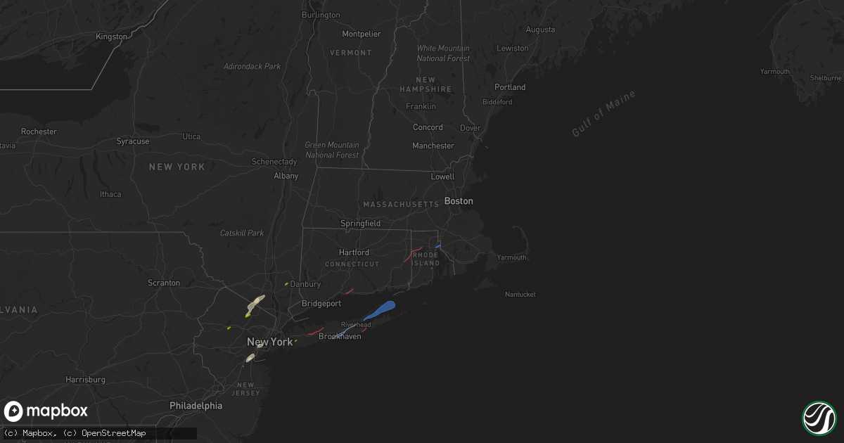
Hail Map in Rhode Island on November 13, 2021
Get this storm
November 13 map
$229
one time, instant access
Download today. No call, no setup
Keep the $229
Bought the map and want the full workflow? Apply the entire $229 to a subscription within 7 days. None of it is wasted.
Every map, not just this one
This buys you this map. Subscription and you get every map we run, in the markets you choose from a few cities to whole states to nationwide. Plus real-time alerts the moment a storm fires.
Contact data
Name, contact info, occupancy, even credit band for addresses in the footprint. You go from where it hit to who to call.
Become the source they trust
Unlimited branding weather history reports on demand. You already have the documented answer ready for the property owner, and you are the one who showed up with it.
Property data and RoofTrace estimates
Pull up any address you have got, its value and the exact code rules for that jurisdiction, straight from One Click Code. Then RoofTrace estimates the squares, pitch, and roof value, priced the way you price.
Storm reports in Rhode Island
Rhode Island
| Date | Description |
|---|---|
| 11/13/20214:22 PM CST | Tree and wires down on lambert lind highway |
| 11/13/20214:20 PM CST | Trees down on the side of route 401 exit to quonset. Debris in roadway. |
| 11/13/20214:20 PM CST | Tree and wires down blocking nichols lane at allen drive |
| 11/13/20214:20 PM CST | Tree down on oakdale road. |
| 11/13/20214:20 PM CST | Tree and wires down... Telephone pole snapped in half... On rocky hill road. |
| 11/13/20214:16 PM CST | Tree and wires down on tall timbers drive. |
| 11/13/20214:05 PM CST | Tree down blocking philips hill road |
| 11/13/20214:05 PM CST | Trees and wires down on johnson road. |
| 11/12/202111:26 PM CST | At 526 PM EST, severe thunderstorms were located along a line extending from Westborough to Seekonk, moving northeast at 50 mph. HAZARD...60 mph wind gusts and penny size hail. SOURCE...Radar indicated. IMPACT...Expect damage to trees and power lines. Locations impacted include... Boston, Providence, Cambridge, Brockton, Quincy, Newton, Pawtucket, Framingham, Waltham, Brookline, Taunton, Weymouth, East Providence, Arlington, Woonsocket, Braintree, Cumberland, Natick, Randolph and North Providence. |
| 11/12/202111:17 PM CST | At 517 PM EST, severe thunderstorms were located along a line extending from Sutton to North Smithfield to near Providence, moving northeast at 50 mph. HAZARD...60 mph wind gusts and penny size hail. SOURCE...Radar indicated. IMPACT...Expect damage to trees and power lines. Locations impacted include... Providence, Brockton, Cranston, Pawtucket, Framingham, Taunton, East Providence, Woonsocket, Marlborough, Shrewsbury, Cumberland, Natick, North Providence, Franklin, Needham, Johnston, North Attleborough, Norwood, Milford and Wellesley. |
All States Impacted by Hail Map on November 13, 2021
Cities Impacted by Hail Map on November 13, 2021
- Tuxedo Park, NY
- Sloatsburg, NY
- Bayonne, NJ
- Elizabeth, NJ
- Elizabethport, NJ
- Toms River, NJ
- Edison, NJ
- Keasbey, NJ
- Sterling Forest, NY
- Ringwood, NJ
- East Brunswick, NJ
- Perth Amboy, NJ
- Sayreville, NJ
- Fords, NJ
- Woodbridge, NJ
- Staten Island, NY
- Port Reading, NJ
- Sewaren, NJ
- South Amboy, NJ
- Bloomingdale, NJ
- Hewitt, NJ
- West Milford, NJ
- Wanaque, NJ
- Butler, NJ
- Southfields, NY
- Pomona, NY
- Stony Point, NY
- Guilford, CT
- Branford, CT
- Moosup, CT
- Sterling, CT
- Plainfield, CT
- Foster, RI
- North Scituate, RI
- Providence, RI
- Rumford, RI
- Seekonk, MA
- East Providence, RI
- Pawcatuck, CT
- Westerly, RI
- North Kingstown, RI
- Kenvil, NJ
- Ledgewood, NJ
- Succasunna, NJ
- Mine Hill, NJ
- Haskell, NJ
- Mahopac, NY
- Hempstead, NY
- Uniondale, NY
- Huntington Station, NY
- Smithtown, NY
- Melville, NY
- Commack, NY
- Saint James, NY
- Manorville, NY
- Patchogue, NY
- Shirley, NY
- Bellport, NY
- Brookhaven, NY
- Yaphank, NY
- Mastic, NY
- Riverhead, NY
- Sag Harbor, NY
- East Hampton, NY
- Shelter Island, NY
- New Suffolk, NY
- Mattituck, NY
- Southold, NY
- Cutchogue, NY
- Shelter Island Heights, NY
- Hampton Bays, NY


