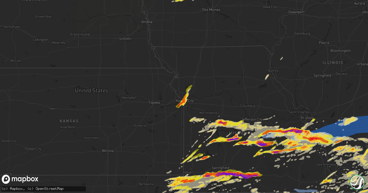
Hail Map on May 8, 2024
Get this storm
May 8 map
$229
one time, instant access
Download today. No call, no setup
Keep the $229
Bought the map and want the full workflow? Apply the entire $229 to a subscription within 7 days. None of it is wasted.
Every map, not just this one
This buys you this map. Subscription and you get every map we run, in the markets you choose from a few cities to whole states to nationwide. Plus real-time alerts the moment a storm fires.
Contact data
Name, contact info, occupancy, even credit band for addresses in the footprint. You go from where it hit to who to call.
Become the source they trust
Unlimited branding weather history reports on demand. You already have the documented answer ready for the property owner, and you are the one who showed up with it.
Property data and RoofTrace estimates
Pull up any address you have got, its value and the exact code rules for that jurisdiction, straight from One Click Code. Then RoofTrace estimates the squares, pitch, and roof value, priced the way you price.
States Impacted by Hail Map on May 8, 2024
Storm reports
Iowa
| Date | Description |
|---|---|
| 05/08/20246:58 PM CDT | A local report indicates 1.00 inch wind near 3 WSW Story City |
| 05/08/20246:52 PM CDT | Report from mping. |
| 05/08/20246:17 PM CDT | A local report indicates 1.00 inch wind near Ogden |
| 05/08/20246:12 PM CDT | Dispatch relayed a report of quarter sized hail in ogden reported by police. |
| 05/08/20244:31 PM CDT | Soft hail... Mostly pea to dime... But a few as big as quarters covered the ground briefly. Melted quickly on the warm... Wet ground in about 15 minutes. No damage noti |
| 05/08/20242:12 PM CDT | Delayed report. Multiple reports of trees with broken limbs. Had one tree blown down in a yard and another tree blown down across a roadway. A few limbs and trees cause |
| 05/07/202410:39 PM CDT | Delayed report. |
| 05/07/20249:55 PM CDT | Hail broke windshield of car. Also strong wind and heavy rain at the time. |
| 05/07/20249:10 PM CDT | Branches down. |
Connecticut
| Date | Description |
|---|---|
| 05/08/20246:14 PM CDT | Time estimated from radar. |
| 05/08/20245:48 PM CDT | Time estimated from radar. |
| 05/08/20245:45 PM CDT | A local report indicates 1.00 inch wind near 1 SW Killingly |
| 05/08/20245:42 PM CDT | Time estimated from radar. |
| 05/08/20243:52 PM CDT | A local report indicates 1.50 inch wind near Pomfret |
| 05/08/20243:44 PM CDT | Time estimated by radar. |
North Carolina
| Date | Description |
|---|---|
| 05/08/20246:58 PM CDT | Corrects location from previous tstm wnd dmg report. Tri-county electric coop reports 79 customers without power between beulaville and potters hill. Time estimated by |
| 05/08/20246:58 PM CDT | Tri-county electric coop reports 79 customers without power between beulaville and potters hill. Time estimated by radar. |
| 05/08/20246:27 PM CDT | Tree down near intersection of gum spring road and nc highway 242. |
| 05/08/20246:20 PM CDT | Tree reported down in stedman. Time estimated by radar. |
| 05/08/20246:17 PM CDT | Tree down at intersection of nc highway 410 and pleasant grove church road. |
| 05/08/20246:14 PM CDT | Tree down at 3023 nc highway 410 |
| 05/08/20246:10 PM CDT | Golfball sized hail just west of the intersection between nc highway 87 and us highways 74/76. |
| 05/08/20246:10 PM CDT | Report of a tree down near sand hill road. Time estimated by radar. |
| 05/08/20246:10 PM CDT | Golfball sized hail just west of the intersection between nc highway 87 and us highways 74/76. |
| 05/08/20246:09 PM CDT | Tree down at intersection of pine tree rd and river rd. |
| 05/08/20246:05 PM CDT | Large tree down in the intersection of bee gee rd and meadow rd. Caller also said there were widespread tree limbs down in the area. |
| 05/08/20246:02 PM CDT | Tree down on southern blvd. |
| 05/08/20245:29 PM CDT | Golfball sized hail on chicken road - reported by pembroke rescue squad. |
| 05/08/20245:29 PM CDT | Golfball sized hail on chicken road - reported by pembroke rescue squad. |
| 05/08/20245:20 PM CDT | Tree down near |
| 05/08/20245:20 PM CDT | Tree down near the intersection of salley mcnair rd & old wire rd. |
| 05/08/20245:16 PM CDT | Tree down near the intersection of sneads grove rd and rea magnet rd. |
| 05/08/20245:16 PM CDT | Trees and powerlines down near the intersection of west blvd and turnpike rd. |
| 05/08/20245:16 PM CDT | Golfball sized hail near intersection of nc highway 11 and nc highway 87. |
| 05/08/20245:16 PM CDT | Golfball sized hail near intersection of nc highway 11 and nc highway 87. |
| 05/08/20245:04 PM CDT | Tree down near the intersection of nc 211 and e main in aberdeen. |
| 05/08/20245:04 PM CDT | Tree down near mo 3791 9074 corrects previous non-tstm wnd dmg report from 2 ssw mineral point. Tree down blocking road at new diggins rd and cook subdivision rd. |
| 05/08/20245:00 PM CDT | Tree down near the intersection of lake forest drive and torrey pines lane. |
| 05/08/20244:54 PM CDT | Golf ball size hail falling on alamac road |
| 05/08/20244:30 PM CDT | Widespread trees and powerlines down from lake tillery through mt. Gilead into the uwharrie national forest. |
| 05/08/20244:28 PM CDT | Multiple trees down near the intersection of hwy 74 and hwy 52 in wadesboro. |
| 05/08/20244:25 PM CDT | Trees down across old baker road |
| 05/08/20244:00 PM CDT | Widespread trees and powerlines down from locust to albemarle. |
| 05/08/20243:59 PM CDT | A couple trees down in southern union county. |
| 05/08/20243:53 PM CDT | Corrects previous time of tstm wnd dmg report f04) 0209 w 3 nne madison madison al 3474 8673 trees down and one on a house near oakland tra |
| 05/08/20243:53 PM CDT | Corrects previous time of tstm wnd dmg report from monroe. Several trees down in the monroe area. |
| 05/08/20243:42 PM CDT | Tree down across morrison road. |
| 05/08/20243:36 PM CDT | Trees down on utility equipment. |
| 05/08/20243:20 PM CDT | A few trees down and power lines down near the charlotte motor speedway. |
| 05/08/20243:15 PM CDT | A few trees down. |
| 05/08/20243:09 PM CDT | Measured on the weatherstem station at bank of america stadium. |
| 05/08/20243:08 PM CDT | Roof damage to the ups center. |
| 05/08/20243:05 PM CDT | Tree down on rowan street. |
| 05/08/20243:05 PM CDT | Trees down on berkshire rd. |
| 05/08/20242:55 PM CDT | Movie screen at a drive-in theater destroyed. |
| 05/08/20242:52 PM CDT | *** 1 fatal... 1 inj *** tree fell on an occupied vehicle at the intersection of s new hope rd and dixon rd. |
| 05/08/20242:49 PM CDT | Emergency management reported numerous trees and power outages in the southwestern portion of lincoln county. |
| 05/08/20242:45 PM CDT | Trees snapped in half and roof ripped off. |
| 05/08/20242:45 PM CDT | Tree down on a house and car in dallas. |
| 05/08/20242:45 PM CDT | Numerous power lines down and a few trees. |
| 05/08/20242:45 PM CDT | *** 2 inj *** two individuals injured by falling trees near intersection of i-85 and us 321. |
| 05/08/20242:40 PM CDT | Quarter sized hail. |
| 05/08/20242:40 PM CDT | This tornado touched down near west davidson ave snapping several trees. The tornado quickly moved to the east and crossed us highway 321 near the i-85 interchange... R |
| 05/08/20242:40 PM CDT | Widespread wind damage across gaston county. Trees down and power lines down in kings mountain area... Bessemer city... And western gastonia. |
| 05/08/20242:40 PM CDT | *** 2 inj *** corrects previous tornado report from 3 nw gastonia. This tornado touched down near west davidson ave snapping several trees. The tornado quickly moved to |
| 05/08/20242:36 PM CDT | Large tree and many large limbs blown down. |
| 05/08/20242:22 PM CDT | Tree uprooted on kingsbury st. |
| 05/08/20242:22 PM CDT | Dime to quarter sized hail. Also strong wind. |
| 05/08/20242:22 PM CDT | At least 2 trees down in shelby. |
| 05/08/20242:15 PM CDT | A few trees snapped or uprooted. |
| 05/08/20242:10 PM CDT | 911 call center reported numerous trees and powerlines down across the polkvill rd. |
| 05/08/20242:10 PM CDT | 911 call center reported numerous trees and powerlines down across the polkville area. |
| 05/08/20242:04 PM CDT | 911 call center reported numerous trees down in the ellenboro area. |
| 05/08/20242:03 PM CDT | 911 call center reported tree blocking roadway near the intersection of shook cove rd and hwy 107. |
| 05/08/20242:00 PM CDT | This tornado touched down along polkville road... Just on the north side of polkville... Where several trees were uprooted. The tornado moved southeast across casar roa |
| 05/08/20241:55 PM CDT | Report of at least quarter sized hail in forest city. |
| 05/08/20241:53 PM CDT | 911 call center reported quarter sized hail at the 911 call center. |
| 05/08/20241:53 PM CDT | Several trees down in the monroe area. |
| 05/08/20241:53 PM CDT | 911 call center reported numerous trees and powerlines down across the forest city area. |
| 05/08/20241:51 PM CDT | 911 call center reported numerous trees and powerlines down in the spindale area. |
| 05/08/20241:50 PM CDT | 911 call center reported numerous trees and powerlines down across the rutherfordton area. |
| 05/08/20241:44 PM CDT | Golf ball hail observed at the family dollar in green hill. Trees were also downed in the area. |
| 05/08/20241:21 PM CDT | Fire marshall reported baseball size hail in lake lure. |
| 05/08/20241:15 PM CDT | 911 call center reported scattered trees down across edneyville. |
| 05/08/20241:15 PM CDT | 911 call center reported tree blocking roadway near hwy 19 west in swain county. |
| 05/08/20241:09 PM CDT | Emergency management reported numerous trees down in the marion area. |
| 05/08/20241:03 PM CDT | Emergency management reported tree on house on forest hill drive off hwy 70 w. |
| 05/08/20241:03 PM CDT | 911 call center reported a tree blocking roadway at the intersection of n canton rd and brady circle. |
| 05/08/20241:00 PM CDT | 911 call center reported tree blocking roadway near the intersection of nellie john rd and thickety rd. |
| 05/08/202412:55 PM CDT | Emergency management reported numerous trees down in the old fort area. |
| 05/08/202412:50 PM CDT | Half dollar sized hail near fairview nc. |
| 05/08/202412:50 PM CDT | A local report indicates 3.00 inch wind near Barnardsville |
| 05/08/202412:27 PM CDT | A local report indicates 1.00 inch wind near 3 NNW Barnardsville |
| 05/08/202412:25 PM CDT | Egg size hail reported. Hail broke 22 car windshields. |
| 05/08/202412:10 PM CDT | Golf ball sized hail. |
| 05/08/202411:55 AM CDT | Quarter sized hail. |
| 05/07/202411:50 PM CDT | Social media report of trees down in the rosman area. |
| 05/07/202411:24 PM CDT | Multiple trees down on power lines between cullowhee and glenville on hwy 107. |
| 05/07/202411:22 PM CDT | Survey confirmed a tornado based on a path of damage in the nantahala national forest in jackson county. Tornado damage observed between tilley creek rd and highway 107 |
| 05/07/202411:18 PM CDT | Multiple trees down across the northern side of black mountain. Possible tornado. |
| 05/07/202411:17 PM CDT | Trees down on power lines and utility equipment between sylva and cullowhee. |
| 05/07/202411:15 PM CDT | Tornado touched down along north fork road where several trees were uprooted... Then moved southeast across allen mountain and across the black mountain golf course whe |
| 05/07/202411:13 PM CDT | Corrects time of previous tstm wnd dmg report from sylva. Trees down on power lines and utility equipment in sylva. |
| 05/07/202411:11 PM CDT | Multiple trees down on power lines along hwy 441 between sylva and franklin. |
| 05/07/202410:55 PM CDT | Widespread trees down across cherokee. |
| 05/07/202410:45 PM CDT | Reports of trees and powerlines down across the county. Also... An amateur radio operator reported a wind gust to 50 mph in the marble area. |
| 05/07/202410:41 PM CDT | A survey found ef-1 tornado damage... With peak winds of 95 mph. Path length was 2.42 miles... Path width was 40 yards. Pockets of extensive tree damage were noted near |
| 05/07/202410:40 PM CDT | Possible tornado damage. Will send survey crew out this morning. Several houses damaged with trees on houses. |
| 05/07/202410:25 PM CDT | Trees down county-wide with time estimated from radar. |
| 05/07/20247:40 PM CDT | Multiple power outages reported by jones-onslow electrical co-op. |
South Carolina
| Date | Description |
|---|---|
| 05/08/20246:05 PM CDT | Several trees blown down across the city |
| 05/08/20246:00 PM CDT | Multiple trees down along freedom blvd in south florence |
| 05/08/20245:35 PM CDT | A tree was downed on hill rd between anderson hill rd and ashland stokes bridge rd. Time estimated. |
| 05/08/20245:35 PM CDT | A tree was downed... Taking down a power line... At law st and s heyward st... In bishopville. Time estimated. |
| 05/08/20245:17 PM CDT | Chesterfield county dispatch reported trees down along patrick society hill road. Time estimated by radar. |
| 05/08/20245:05 PM CDT | Chesterfield county dispatch reported trees down along sandy run creek. Time estimated by radar. |
| 05/08/20244:20 PM CDT | Trees and limbs down on power lines on south lake drive. |
| 05/08/20244:12 PM CDT | Sc highway patrol reported a tree in roadway at flat creek road and mccowan lane. Time estimated by radar. |
| 05/08/20244:05 PM CDT | County official reports many trees down across the county. |
| 05/08/20243:50 PM CDT | Spotter report of several trees down along shelly mullis road in indian land. Time estimated by radar. |
| 05/08/20243:45 PM CDT | Corrects previous tstm wnd dmg report from chester. County official reports many trees down across the county. |
| 05/08/20243:39 PM CDT | Social media pictures of at least golf ball size hail in the santuc area. |
| 05/08/20243:35 PM CDT | 8-9 trees blown down near carlisle. |
| 05/08/20243:35 PM CDT | A few trees blown down north of york. |
| 05/08/20243:02 PM CDT | Quarter size hail observed at the tyger river correctional institute. |
| 05/08/20243:00 PM CDT | Corrects time of previous hail report from 5 nne cross anchor. Quarter size hail observed at the tyger river correctional institute. |
| 05/08/20242:30 PM CDT | Along i-85 near i-26 intersection numerous small to somewhat large limbs down ion jefferson il 3832 8890 trees down power outages. |
| 05/08/20242:30 PM CDT | Along i-85 near i-26 intersection numerous small to somewhat large limbs down in the area. Seems to have caused power outages. Dime sized hail. |
| 05/08/20242:00 PM CDT | Golfball size hail. |
| 05/08/20241:55 PM CDT | Got at least 2 reports of quarter sized hail on woodruff road. |
| 05/08/20241:39 PM CDT | Emergency management reported tree down on powerline in landrum. |
| 05/08/20241:25 PM CDT | Hail lasted five minutes. |
| 05/08/20241:04 PM CDT | Report from mping: quarter |
| 05/08/202412:52 PM CDT | Dime to half dollar sized hail. |
| 05/08/202412:50 PM CDT | Several large hail stones in odd shapes. |
| 05/08/202412:35 PM CDT | Social media report of quarter sized hail northern lake keowee. |
| 05/08/202412:26 PM CDT | Employees enroute to storm survey discovered trees down on whitewater falls rd. Time estimated from radar. |
| 05/08/20243:32 AM CDT | Large tree down at corner of galloway town rd and indian branch rd causing two traffic accidents no injuries reported. |
| 05/08/20243:22 AM CDT | Sc dot reports a tree in roadway along i20. Time estimated by radar. |
| 05/08/20243:20 AM CDT | Sumter county dispatch reports a tree down along 378 and north kings highway. Time estimated by radar. |
| 05/08/20242:57 AM CDT | Kershaw county fire reports a tree blocking roadway along hwy 261 at hwy 521. Time estimated based on radar. |
| 05/08/20242:56 AM CDT | Kershaw county dispatch reports numerous trees and powerlines down throughout the county. Time estimated by radar. |
| 05/08/20242:56 AM CDT | Kershaw county fire reported a tree down blocking the road along flat rock rd. Time estimated based on radar. |
| 05/08/20242:53 AM CDT | Kershaw county fire reports a tree down on a home in lugoff. Time estimated based on radar. |
| 05/08/20242:52 AM CDT | Kershaw county fire reports a tree down blocking roadway. Time estimated based on radar. |
| 05/08/20242:49 AM CDT | Kershaw county em reported a tree down blocking roadway along flat rock rd. |
| 05/08/20242:49 AM CDT | Kershaw county fire reported a tree down at the intersection of smyrna rd and ashley creek. Time estimated based on radar. |
| 05/08/20242:49 AM CDT | Kershaw county em reported a tree down blocking flat rock rd at the kershaw/lancaster county line. Time estimated based on radar. |
| 05/08/20242:45 AM CDT | Emergency manager reports a downed tree on smyrna church rd at smyrna rd blocking the roadway. |
| 05/08/20242:38 AM CDT | Sc dept of public safety reported a tree in roadway. Time estimated by radar. |
| 05/08/20242:37 AM CDT | Emergency manager reports a downed tree on singleton creek rd at liberty hill rd blocking the roadway. |
| 05/08/20242:36 AM CDT | Trained spotter reported trees down and heavy damage between ridgeway and the county line. Time estimated by radar. |
| 05/08/20242:34 AM CDT | Report of a tree down and minor damage to a home in ridgeway. Report via social media. Time estimated by radar. |
| 05/08/20242:33 AM CDT | Trained spotter reported numerous trees down along hood rd through the intersection with boney rd. Time estimated from radar. |
| 05/08/20242:31 AM CDT | A national weather service storm survey team confirmed an ef-1 tornado with peak winds of 100 mph in southeastern fairfield county during the early morning hours of may |
| 05/08/20242:30 AM CDT | Sc dept of public safety reported a tree in roadway. Time estimated by radar. |
| 05/08/20242:28 AM CDT | Sc dept of public safety reported a tree in roadway. Time estimated by radar. |
| 05/08/20242:20 AM CDT | Sc department of public safety reported a tree down in roadway. Time estimated based on radar. |
| 05/08/20242:17 AM CDT | Fairfield county dispatch reported trees down in the 7489 block of hwy 213. Time estimated by radar. |
| 05/08/20242:12 AM CDT | A national weather service storm survey team confirmed a brief ef-0 tornado with peak winds of 80 mph in northwestern fairfield county during the early morning hours of |
| 05/08/20242:12 AM CDT | Newberry county em reported a tree down on wheeland & mill rd. Time estimated by radar. |
| 05/08/20242:08 AM CDT | Fairfield county dispatch reports a tree down along hwy 215 at meadow lake rd. Time estimated by radar. |
| 05/08/20242:04 AM CDT | Newberry county em reported a tree down along broad river road. Time estimated based on radar. |
| 05/08/20242:02 AM CDT | Newberry county dispatch reports trees down at mt pleasant rd and glynphville rd. Time estimated by radar. |
| 05/08/20241:57 AM CDT | Newberry county dispatch reported trees down at 2nd st and digby st. Time estimated by radar. |
| 05/08/20241:55 AM CDT | Sc dept of public safety reported a tree in roadway. Time estimated by radar. |
| 05/08/20241:54 AM CDT | Newberry county dispatch reported trees down at belfast & spearman rd. Time estimated by radar. |
| 05/08/20241:54 AM CDT | Saluda county dispatch reported a tree down along greenwood highway. Time estimated by radar. |
| 05/08/20241:54 AM CDT | Sc dept of public safety reported a tree in roadway. Time estimated by radar. |
| 05/08/20241:53 AM CDT | Newberry county em reported a tree down at indian creek rifle range. Time estimated based on radar. |
| 05/08/20241:52 AM CDT | Newberry county em reported trees and powerlines down at colonial dr and sc 121. Time estimated based on radar. |
| 05/08/20241:46 AM CDT | Newberry county dispatch reported trees down at kings ln and old airport rd. Time estimated by radar. |
| 05/08/20241:46 AM CDT | A national weather service storm survey team confirmed a brief ef-0 tornado with peak winds of 80 mph in newberry county south of the town of whitmire during the early |
| 05/08/20241:45 AM CDT | Trees and utility lines downed along hwy 66. |
| 05/08/20241:30 AM CDT | Corrects previous non-tstm wnd gst report from 2 ssw ora. Scdot station i-385 & hwy 221. |
| 05/08/202412:54 AM CDT | Trees snapped and uprooted on woodside ave. |
| 05/08/202412:53 AM CDT | Tree down on hwy 252 near belton hwy. Time estimated from radar. |
| 05/08/202412:53 AM CDT | Tree down on jule martin rd near honea path hwy. Time estimated from radar. |
| 05/08/202412:52 AM CDT | Tree down on hwy 413 near grove rd. Time estimated from radar. |
| 05/08/202412:52 AM CDT | Tree down on honea path hwy. Time estimated from radar. |
| 05/08/202412:51 AM CDT | Tree down on snow rd. Time estimated from radar. |
| 05/08/202412:51 AM CDT | Multiple buildings with roof and awning damage in downtown anderson. |
| 05/08/202412:50 AM CDT | Tree down on w whitner st. |
| 05/08/202412:50 AM CDT | Tree uprooted on w whitner st. Power lines down. |
| 05/08/202412:50 AM CDT | Tree down on bolt dr. Radar. |
| 05/08/202412:50 AM CDT | Tree down on amity rd. |
| 05/08/202412:50 AM CDT | Tree down on old williamston rd. |
| 05/08/202412:50 AM CDT | Tree down on bolt dr. |
| 05/08/202412:47 AM CDT | Anderson regional airport. |
| 05/08/202412:45 AM CDT | Tree on a car near east whitner... Also trees downed along rr tracks. |
| 05/08/202412:40 AM CDT | Tree blocking lane of i-85 south... Mm33. |
Tennessee
| Date | Description |
|---|---|
| 05/08/20246:52 PM CDT | Photo received of large tree down and tree resting on powerlines and on top of a house. Time is radar estimated. Tornado damage possible. |
| 05/08/20246:51 PM CDT | 70 mph winds reported in christiana. Time is radar estimated. Tornado possible. |
| 05/08/20246:49 PM CDT | Steeple blown off north carthage baptist church... Cars also damaged by falling trees in the area. Possible tornado damage. |
| 05/08/20246:47 PM CDT | Structure damage reported along carmack and colonial avenue in carthage. Time is radar estimated. Tornado damage possible. |
| 05/08/20246:43 PM CDT | Photos received on social media of trees snapped and a large tree uprooted along cullum street. Structural damage to a house caused by fallen tree. Tornado damage possi |
| 05/08/20246:42 PM CDT | Photos received on social media of numerous trees and powerlines down along jefferson ave. Time is radar estimated. Tornado damage possible. |
| 05/08/20246:42 PM CDT | A local report indicates 70 MPH wind near 7 S Murfreesboro |
| 05/08/20246:40 PM CDT | Delayed report - tree damage and multiple uprooted trees in lebanon off of carthage highway. |
| 05/08/20246:34 PM CDT | Corrected report for time. Trees and powerlines reported down in dickson springs west of carthage. Time is radar estimated. Possible tornado damage. |
| 05/08/20246:31 PM CDT | An ef-0 tornado touched down near the intersection of threet rd and new zion rd. The tornado moved east along new zion rd snapping large branches off from hardwood tree |
| 05/08/20246:30 PM CDT | Trees were blown down and outbuildings were damaged along taylorsville rd. |
| 05/08/20246:22 PM CDT | Lucky ladd farms received structural damage and has numerous trees down. Time is radar estimated. Tornado damage possible. |
| 05/08/20246:21 PM CDT | Broken tree limbs and snapped power poles reported from severe thunderstorm winds east of hartsville. |
| 05/08/20246:10 PM CDT | Several trees were blown down in hartsville. |
| 05/08/20246:10 PM CDT | Uprooted trees reported along hidden woods trail east of gallatin from severe thunderstorm winds. |
| 05/08/20246:05 PM CDT | Multiple large trees were blown down near bledsoe creek state park. |
| 05/08/20246:03 PM CDT | A local report indicates 1.00 inch wind near 1 SSE Inglewood |
| 05/08/20246:00 PM CDT | Facebook report of numerous trees down in the taylorsville area along with a collapsed barn. |
| 05/08/20245:57 PM CDT | Photo received of tree down with damage to fence on either side. Time is radar estimated. Possible tornado damage. |
| 05/08/20245:57 PM CDT | Facebook report of a tree down along woods ferry road just south of gallatin. |
| 05/08/20245:57 PM CDT | Thunderstorm wind damage reported just south of gallatin... Including broken tree limbs and broken power poles. |
| 05/08/20245:57 PM CDT | Photos received of tress down on fence. Time is radar estimated. Possible tornado damage. |
| 05/08/20245:53 PM CDT | Significant... Large tornado reported. |
| 05/08/20245:48 PM CDT | Photo received of significant amount of damage done to an rv and the surrounding area. Multiple trees snapped... Furniture flipped... Rv toppled over. Time is radar est |
| 05/08/20245:45 PM CDT | Large tree down along dawn court. |
| 05/08/20245:44 PM CDT | A local report indicates a tornado near 4 ENE Columbia |
| 05/08/20245:43 PM CDT | Estimated quarter size hail. |
| 05/08/20245:37 PM CDT | *** 1 fatal... 1 inj *** this ef-3 tornado touched down along the duck river east of columbia and moved northeast causing tree damage and minor structure damage on moun |
| 05/08/20245:34 PM CDT | Trees and powerlines reported down in dickson springs west of carthage. Time is radar estimated. Possible tornado damage. |
| 05/08/20245:34 PM CDT | Report from mping: half dollar |
| 05/08/20245:30 PM CDT | Several trees were blown down along fern valley road. |
| 05/08/20245:30 PM CDT | Several trees were blown down near intersection of meadows and n palmers chapel rd. |
| 05/08/20245:30 PM CDT | Estimated 2 inch hail. |
| 05/08/20245:29 PM CDT | Trees and powerlines down on thomas road near the county line of trousdale/wilson counties. Tornado damage possible. |
| 05/08/20245:28 PM CDT | Trees and powerlines down. Time is radar estimated. |
| 05/08/20245:28 PM CDT | Trees and powerlines down on overlook road. Time is radar estimated. |
| 05/08/20245:17 PM CDT | Report from mping: quarter |
| 05/08/20245:15 PM CDT | A local report indicates 2.00 inch wind near 2 N White House |
| 05/08/20245:09 PM CDT | Report from mping: quarter |
| 05/08/20245:00 PM CDT | Facebook report of estimated golf ball size hail along baggett road east of springfield. |
| 05/08/20244:54 PM CDT | Estimated golf ball size hail. |
| 05/08/20244:44 PM CDT | Estimated 1.5 inch hail. |
| 05/08/20244:43 PM CDT | A local report indicates 1.75 inch wind near Hohenwald |
| 05/08/20244:43 PM CDT | Estimated golf ball size hail. |
| 05/08/20244:36 PM CDT | Report from mping: half dollar |
| 05/08/20244:24 PM CDT | Trees and powerlines down. Time is radar estimated. |
| 05/08/20244:17 PM CDT | A local report indicates 2.00 inch wind near 5 SSW Clarksville |
| 05/08/20244:15 PM CDT | Reported in the flat woods area. |
| 05/08/20244:08 PM CDT | A local report indicates 1.75 inch wind near Clarksville |
| 05/08/20244:05 PM CDT | Trees and powerlines down near pine view. Time is radar estimated. |
| 05/08/20243:54 PM CDT | A local report indicates 1.25 inch wind near 1 SSE Portland |
| 05/08/20243:44 PM CDT | A local report indicates 1.75 inch wind near 1 WNW Paris |
| 05/08/20243:37 PM CDT | . |
| 05/08/20243:36 PM CDT | A local report indicates 1.00 inch wind near 2 W Parsons |
| 05/08/20243:34 PM CDT | A local report indicates 1.00 inch wind near 1 NW Paris |
| 05/08/20243:33 PM CDT | A local report indicates 2.00 inch wind near 1 WNW Paris |
| 05/08/20243:30 PM CDT | A local report indicates 3.00 inch wind near 1 E Bumpus Mills |
| 05/08/20243:28 PM CDT | Report from mping: quarter |
| 05/08/20243:22 PM CDT | A local report indicates 1.00 inch wind near Bumpus Mills |
| 05/08/20243:20 PM CDT | South of chesterfield along highway 114 approximately two miles south of highway 412. |
| 05/08/20242:54 PM CDT | Still ongoing northwest of coopertown. Exact location estimated by radar. |
| 05/08/20242:47 PM CDT | Reported by spotter on mile marker 19 on i-24. |
| 05/08/20242:20 PM CDT | Twitter photo showed hail up to quarter size in the beaman park area. |
| 05/08/20242:20 PM CDT | Facebook report of a tree snapped near mcadoo creek road and highway 12 along with damage to a barn roof. |
| 05/08/202411:10 AM CDT | Few trees down. |
| 05/08/202410:48 AM CDT | A local report indicates 1.25 inch wind near 2 ENE Liberty |
| 05/08/202410:15 AM CDT | A local report indicates 1.50 inch wind near Mosheim |
| 05/08/20249:55 AM CDT | Roof... Window... And other structural damage to russellville intermediate school. |
| 05/08/20249:50 AM CDT | Corrected time of previous tstm wnd dmg report from 1 wsw russellville. Roof damage to the mausoleum at hamblen memory gardens. |
| 05/08/20249:45 AM CDT | Tree down on home on quillen drive. |
| 05/08/20249:45 AM CDT | Tree down on home on quillen drive. The intersection of salley mcnair rd & old wire rd. |
| 05/08/20249:45 AM CDT | Tree on house on old liberty hill rd. |
| 05/08/20249:45 AM CDT | Large trees down. |
| 05/08/20249:44 AM CDT | A local report indicates 1.00 inch wind near Morristown |
| 05/08/20249:35 AM CDT | A local report indicates 1.50 inch wind near Bean Station |
| 05/08/20249:25 AM CDT | Trees and power lines down countywide. |
| 05/08/20249:20 AM CDT | A local report indicates 2.50 inch wind near Rutledge |
| 05/08/20248:55 AM CDT | Roof damage to the mausoleum at hamblen memory gardens. |
| 05/08/20248:55 AM CDT | *** 1 fatal *** trees down. Home destroyed. Tree fell on car killing the occupant at the intersection of lone mountain rd... And jennings lane. |
| 05/08/20248:55 AM CDT | Roof damage to the mausoleum at hamblen memory gardens. E area. |
| 05/08/20248:50 AM CDT | Trees down. |
| 05/08/20247:55 AM CDT | Trees down. |
| 05/08/20247:43 AM CDT | Trees down on west main street in livingston. |
| 05/08/20247:40 AM CDT | Trees down on walnut grove road. |
| 05/08/20247:39 AM CDT | A local report indicates 1.75 inch wind near 7 WNW Livingston |
| 05/08/20247:39 AM CDT | . |
| 05/08/20247:06 AM CDT | Downed trees. Delayed report. |
| 05/08/20247:05 AM CDT | . |
| 05/08/20247:05 AM CDT | A local report indicates 1.00 inch wind near 1 SSE Red Boiling Sprin |
| 05/08/20245:15 AM CDT | Several trees down across the southern portion of the county. Relayed to us by amateur radio operator from public radio. |
| 05/08/20245:10 AM CDT | Trees down. |
| 05/08/20244:50 AM CDT | Several large trees have been blown down with multiple power outages in the area. |
| 05/08/20244:30 AM CDT | Numerous reports of trees down across the county. Time estimated by radar. |
| 05/08/20243:27 AM CDT | Trees down along cherry drive. Time is radar estimated. |
| 05/08/20243:23 AM CDT | Facebook report of a tree down near collins hollow road and old lake road in lewisburg. |
| 05/08/20243:20 AM CDT | Video received on social media of numerous branches down and 2 large trees uprooted along crescent view road south of pulaski. Time is radar estimated. |
| 05/08/20243:17 AM CDT | Trees and powerlines down along jones hollow road. Time is radar estimated. |
| 05/08/20243:02 AM CDT | Reports of tree and powerline damage in lawrence county including weakly creek road... Bonee road near gimlet road and martin road. Time estimated via radar. |
| 05/08/20243:02 AM CDT | Photos received of large trees uprooted along crews road west of etheridge. Time is radar estimated. |
| 05/08/20243:00 AM CDT | Trees down between napier and new prospect. |
| 05/08/20242:50 AM CDT | Several trees down in the laurel hill wildlife management area. |
| 05/08/20241:39 AM CDT | An ef0 tornado touched down 9 miles ssw new johnsonville and traveled 1.31 miles over 2 minutes causing intermittent tree damage. |
| 05/08/20241:07 AM CDT | A few trees down at orgill park golf course. |
| 05/08/202412:56 AM CDT | 2 large mature trees down on pleasant hill road. A power pole also came down due to the fallen tree. |
| 05/08/202412:55 AM CDT | Trees/powerlines down on mudville rd north of millington. |
| 05/08/202412:53 AM CDT | Several trees down along wilkinsville road. |
| 05/08/202412:50 AM CDT | Awos station knqa millington. |
| 05/08/202412:30 AM CDT | Tree down on home. |
| 05/08/202412:28 AM CDT | Trees down in sharon. |
| 05/08/202412:25 AM CDT | Large tree and powerlines down in fonville street. Large tree blocking jackson street. |
| 05/08/202412:20 AM CDT | Tree down on highway 431. |
| 05/07/202411:55 PM CDT | Several manufactured homes damaged and trees down between hornbeak and obion. |
| 05/07/202410:05 PM CDT | Couple of trees blown down on either side of new market... Tn. Time estimated by radar. |
| 05/07/20249:55 PM CDT | One tree down. |
| 05/07/20249:45 PM CDT | Trees and powerlines down across the county. Much of downtown maryville is without power. Also... A tree caught on fire due to downed powerlines. |
| 05/07/20249:30 PM CDT | Trees down. |
| 05/07/20249:30 PM CDT | Trees and powerlines down along vinegar valley road. |
| 05/07/20249:25 PM CDT | A local report indicates 1.50 inch wind near South Pittsburg |
| 05/07/20249:25 PM CDT | Trees down. |
| 05/07/20249:15 PM CDT | Trees down across the county with time estimated from radar. |
| 05/07/20249:11 PM CDT | Report from mping: quarter |
| 05/07/20249:10 PM CDT | Trees down close to athens. Location approximate. Time estimated by radar. |
| 05/07/20249:10 PM CDT | Trees down. |
| 05/07/20249:00 PM CDT | Trees and powerlines down county-wide. |
| 05/07/20248:55 PM CDT | Emergency manager reported hail from a trained spotter. |
| 05/07/20248:55 PM CDT | Large tree down completely blocking roadway on the 800 block of geedsville. Possible tornado damage. |
| 05/07/20248:50 PM CDT | Trees down. |
| 05/07/20248:50 PM CDT | Trees down on highway 61. Time estimated by radar. |
| 05/07/20248:50 PM CDT | Trees down in the old quick rd and south patrick rd area. |
| 05/07/20248:43 PM CDT | Report from mping: tea cup |
| 05/07/20248:34 PM CDT | Corrects previous tstm wnd dmg report from 7 ese manchester. Facebook report of a tree down near the intersection of highway 41 and highway 127 in hillsboro. |
| 05/07/20248:27 PM CDT | Facebook report of a tree down on hillsboro viola road north of hillsboro. |
| 05/07/20248:23 PM CDT | Numerous trees down and barn damage near blanch rd. Possible tornado. |
| 05/07/20248:20 PM CDT | A national weather service huntsville... Al and lincoln co. Ema damage assessment team determined the damage in southwest lincoln co. Was consistent with an ef-1 tornad |
| 05/07/20248:20 PM CDT | Corrects previous tstm wnd dmg report from 1 nw manchester. Facebook report of a downed tree on taylor street in manchester. |
| 05/07/20248:19 PM CDT | Uprooted trees reported south of centertown. |
| 05/07/20248:18 PM CDT | Facebook report of a downed tree along elrod road in manchester. |
| 05/07/20248:15 PM CDT | Ef-1 with peak wind speed of 105 mph... Path length of 6.22 miles... And maximum path width of 160 yard. This is still preliminary. |
| 05/07/20248:15 PM CDT | Trees down on nydeck trail that have resulted in powerlines being knocked down. Location approximate and timing based on radar. |
| 05/07/20248:14 PM CDT | Facebook report of a tree and power line down on river bluff road in manchester. |
| 05/07/20248:13 PM CDT | Corrects previous hail report from manchester. Facebook report of estimated 2 hail with photo near manchester tn. |
| 05/07/20248:02 PM CDT | Numerous trees down near roger monk rd. Possible tornado. |
| 05/07/20247:50 PM CDT | *** 1 inj *** tress down and mobile home demolished. Tornado damage possible. |
| 05/07/20247:41 PM CDT | Several trees down on property around 6100 block of manchester highway. |
| 05/07/20247:40 PM CDT | Photo received of hailstone along midland road near the airport in shelbyville. Time is radar estimated. |
| 05/07/20247:36 PM CDT | Facebook report of estimated golf ball size along midland road near shelbyville airport. |
| 05/07/20247:34 PM CDT | Facebook report of a tree down near the intersection of highway 41 and highway 127 in hillsboro. |
| 05/07/20247:20 PM CDT | Facebook report of a downed tree on taylor street in manchester. |
| 05/07/20247:07 PM CDT | Estimated quarter size hail. |
Rhode Island
| Date | Description |
|---|---|
| 05/08/20246:49 PM CDT | Time estimated from radar. |
| 05/07/20248:58 PM CDT | Corrects previous hail report from 1 ne narragansett for location. Social media photo of 2 inch diameter hailstones in narragansett. Also was relayed by amateur radio. |
| 05/07/20248:58 PM CDT | Social media photo of 2 inch diameter hailstones in narragansett. Also was relayed by amateur radio. |
| 05/07/20248:53 PM CDT | Delayed report. Varying ranges of hail size... Up to golf ball. Vehicle hood dented from hail. |
| 05/07/20248:51 PM CDT | Time estimated from radar. |
| 05/07/20247:06 PM CDT | Time estimated from radar. |
Texas
| Date | Description |
|---|---|
| 05/08/202412:49 AM CDT | 1 inch hail reported near the intersection of north kings highway and interstate 30. |
| 05/07/20249:25 PM CDT | Golf ball hail at highway 19 and cr 1174. |
| 05/07/20249:10 PM CDT | Golf ball hail at fm 499 and fm 275 in cumby. |
| 05/07/20248:57 PM CDT | Corrects previous non-tstm wnd gst report from lone oak. Measured gust to 61 mph in lone oak. |
| 05/07/20248:40 PM CDT | A local report indicates 1.75 inch wind near 5 S Greenville |
| 05/07/20248:40 PM CDT | Trees reported down on cr 2235 near bagwell. Time estimated by radar. |
| 05/07/20248:31 PM CDT | Delayed report report from mping: quarter |
| 05/07/20248:30 PM CDT | Numerous reports of quarter-size hail in and near greenville from 8:30 and 8:45 pm. |
| 05/07/20248:27 PM CDT | A short tornado damage path was found south of pinhook by local law enforcement. Small tree limbs and light tin metal damage was observed. This path location is estimat |
| 05/07/20248:23 PM CDT | Quarter hail on the north side of caddo mills. |
| 05/07/20248:05 PM CDT | A local report indicates 1.25 inch wind near 3 NW Josephine |
| 05/07/20247:50 PM CDT | Picture sent of 2 inch hail in chicota. |
| 05/07/20247:47 PM CDT | Delayed report report from mping: quarter |
| 05/07/20247:45 PM CDT | Corrects previous non-tstm wnd gst report from 14 n paris. Em relayed report of 60 mph wind and quarter hail near chicota. |
| 05/07/20247:45 PM CDT | Golf ball hail at pat mayse dam. |
| 05/07/20247:40 PM CDT | Correction: spotters and chasers reported a very brief touchdown along fm 1499... About 1 mile south of fm 197... Just west of pat mayse lake. The em found small tree b |
| 05/07/20247:40 PM CDT | Live spotter video captured a brief touchdown along fm 1499... About 1 mile south of fm 197... Just west of pat mayse lake. Thereafter... A funnel traversed the length |
Illinois
| Date | Description |
|---|---|
| 05/08/20246:58 PM CDT | Power lines knocked over in town. Fire chief reports trees down and entire town without power. |
| 05/08/20246:45 PM CDT | Tree down over roadway... Relayed via email with picture. |
| 05/08/20246:36 PM CDT | Several trees and power lines down in sparta. |
| 05/08/20246:16 PM CDT | Power pole down across roadway south of red bud and tree on house in red bud. Minor damage to house. |
| 05/08/20246:00 PM CDT | Tree branches down. |
| 05/08/20245:30 PM CDT | Reports of quarter sized hail in mascoutah. |
| 05/08/20245:20 PM CDT | Air force forecaster in belleville. |
| 05/08/20245:18 PM CDT | Spotter held quarter next to hail... Was slightly larger. |
| 05/08/20244:40 PM CDT | Report from mping: 1-inch tree limbs broken; shingles blown off. |
| 05/08/20244:29 PM CDT | Tornado reported five miles southwest of equality. |
| 05/08/20244:20 PM CDT | Eagle coal building damaged. |
| 05/08/20244:19 PM CDT | Ping pong ball sized hail. |
| 05/08/20244:16 PM CDT | Likely tornado damage to a large outbuilding near highway 145 and willow grove road. Time estimated. |
| 05/08/20244:13 PM CDT | Several dozen trees snapped or uprooted along with many large branches broken along the path. A few homes and barns with minor roof damage. One home was slightly shifte |
| 05/08/20244:04 PM CDT | An ef-0 tornado did intermittent damage from the central subdivisions of the lake of egypt community to just south of creal springs in williamson county... Il. The grea |
| 05/08/20243:33 PM CDT | Quarter size hail. |
| 05/08/20243:32 PM CDT | Trees down. |
| 05/08/20243:32 PM CDT | Trees down. |
| 05/08/20243:25 PM CDT | Golf ball size hail. |
| 05/08/20243:17 PM CDT | Trees down. |
| 05/08/20243:15 PM CDT | Video of a tornado shared on social media southeast of carbondale. Time and location approximate. |
| 05/08/20243:10 PM CDT | Damage was mainly to tree limbs along a path beginning southeast of carbondale along giant city blacktop. Several large tree limbs were downed on wagon wheel road and c |
| 05/08/20242:27 PM CDT | Golf ball sized hail reported northeast of chester. |
| 05/08/20242:24 PM CDT | Report from mping: half dollar |
| 05/08/20242:15 PM CDT | Public reported quarter sized hail. |
| 05/08/20242:12 PM CDT | A local report indicates 2.50 inch wind near Ellis Grove |
| 05/08/20242:08 PM CDT | Quarter sized hail just south of evansville. |
| 05/08/20241:22 PM CDT | Golf ball sized hail south of valmeyer. |
| 05/08/20241:14 PM CDT | Estimated from picture. Golf ball to tennis ball sized hail in festus. |
| 05/08/202412:55 PM CDT | Report from mping: quarter |
| 05/08/202412:02 PM CDT | *** 1 inj *** mobile home shifted off foundation... Older barn roof damage... Travel trailer flipped over. Multiple trees snapped.... |
| 05/08/202412:01 PM CDT | *** 1 inj *** an ef-1 tornado impacted the the community of cora in extreme western jackson county... Il. The tornado began south of cora where it uprooted a tree in th |
| 05/07/20248:40 PM CDT | Golf ball sized hail. |
| 05/07/20248:32 PM CDT | A local report indicates 1.00 inch wind near Harrisburg |
| 05/07/20247:55 PM CDT | Delayed report. Co-op observer reported tree limbs down... High-line pole blown over... And satellite dishes blown off of a home. |
| 05/07/20247:44 PM CDT | Measured from private anemometer. |
| 05/07/20247:44 PM CDT | Several trees and power poles blown down from xenia east to highway 45. |
| 05/07/20247:42 PM CDT | Estimated winds of 60-70 mph with dime size hail. |
| 05/07/20247:42 PM CDT | Trees down and power lines down over road. |
| 05/07/20247:41 PM CDT | Large tree and power lines down on highway 161 west of highway 45. |
| 05/07/20247:35 PM CDT | Estimated wind gusts 60 mph along the clay and wayne county border. |
| 05/07/20247:28 PM CDT | Report from mping: 3-inch tree limbs broken; power poles broken. |
| 05/07/20247:21 PM CDT | Facebook report. |
| 05/07/20247:21 PM CDT | Trees down power outages. |
| 05/07/20247:15 PM CDT | Report from mping: 3-inch tree limbs broken; power poles broken. |
| 05/07/20247:13 PM CDT | Power pole over roadway with energized lines. |
| 05/07/20247:08 PM CDT | Tree down closing woods lane. |
| 05/07/20247:00 PM CDT | Report from mping: quarter |
Kentucky
| Date | Description |
|---|---|
| 05/08/20246:59 PM CDT | A tree was reported to have been blown down onto ky 834 w about 0.25 miles from ky 90. The event time is radar estimated. |
| 05/08/20246:59 PM CDT | Numerous power outages reported across butler county. Reported by wxornotbg on social media. |
| 05/08/20246:57 PM CDT | Trees and limbs down and ham radio antenna damaged on chester johnson road. |
| 05/08/20246:56 PM CDT | Powerlines were reported to have been blown down on old bethel church road. The event time is radar estimated. |
| 05/08/20246:50 PM CDT | Few trees down in area of knifley road and holmes bend road. |
| 05/08/20246:50 PM CDT | Kentucky mesonet observation. |
| 05/08/20246:40 PM CDT | Trees down on a house in campbellsville. |
| 05/08/20246:30 PM CDT | Generic information of trees and powerlines down across the county. |
| 05/08/20245:51 PM CDT | Power lines down over road. |
| 05/08/20245:25 PM CDT | Large tree fell on home and garage walls and roof blown down. Reported by public on social media with pictures. |
| 05/08/20245:20 PM CDT | Tree and powerline down across ky highway 210. |
| 05/08/20245:14 PM CDT | Delayed report of multiple trees down in fountain run. |
| 05/08/20244:38 PM CDT | Picture of golf ball size hail sent to the nws near rt 68 and mell rd. |
| 05/08/20244:25 PM CDT | Tree down over road... And water over road. |
| 05/08/20244:20 PM CDT | A few trees down near ky 551/ ky 70. |
| 05/08/20244:12 PM CDT | A local report indicates 1.00 inch wind near Pleasant Ridge |
| 05/08/20244:07 PM CDT | Media report of golf ball size hail south of clarkson. |
| 05/08/20244:07 PM CDT | Media report of golf ball size hail near clarkson. |
| 05/08/20244:03 PM CDT | Trees down reported. |
| 05/08/20244:02 PM CDT | Video shared on social media of a tornado over lake barkley. Location approximate. |
| 05/08/20244:01 PM CDT | A local report indicates 1.00 inch wind near 5 NNW Fort Campbell Nor |
| 05/08/20243:56 PM CDT | Trees down. |
| 05/08/20243:55 PM CDT | Report from mping: quarter |
| 05/08/20243:54 PM CDT | Quarter sized hail reported by public and shared by wxornotbg on social media. |
| 05/08/20243:40 PM CDT | Tree limbs down across ky highway 2094 in the waverly community. Time estimated by radar. |
| 05/08/20243:39 PM CDT | Telephone pole blown down on ky141 at tl bishop rd. |
| 05/08/20243:39 PM CDT | Telephone pole blown down on ky141 at tl bishopthe intersection of nc 211 and e main in aberdeen. |
| 05/08/20243:38 PM CDT | Corrects previous hail report from 1 ssw exie. Picture of golf ball size hail sent to the nws near rt 68 and mell rd. Time corrected. |
| 05/08/20243:35 PM CDT | Large trees uprooted... Tree fell on house. |
| 05/08/20243:35 PM CDT | Corrects previous tstm wnd dmg report from livermore. Large trees uprooted... Tree fell on house. Damage to porch. |
| 05/08/20243:17 PM CDT | Video showing quarter sized hail falling on residential property reported by public on social media. |
| 05/08/20243:15 PM CDT | Golfball size hail reported with pictures off of highway 88 near us31e. |
| 05/08/20243:10 PM CDT | Report from mping: quarter |
| 05/08/20243:08 PM CDT | Reported in the area of seymour-bear wallow rd and hwy 218. |
| 05/08/20243:02 PM CDT | Golf ball size hail reported in morgantown at the cross roads of provo rd and meredith rd. |
| 05/08/20243:00 PM CDT | Trees down... Hail damage to vehicles and one house with significant damage... Power outages reported. |
| 05/08/20243:00 PM CDT | A local report indicates 1.75 inch wind near 1 SE Drakesboro |
| 05/08/20242:53 PM CDT | A local report indicates 1.75 inch wind near 1 ESE Cave City |
| 05/08/20242:53 PM CDT | Trees down. |
| 05/08/20242:53 PM CDT | A local report indicates 1.50 inch wind near 1 ESE Cave City |
| 05/08/20242:45 PM CDT | A local report indicates 1.00 inch wind near 3 SSE Drakesboro |
| 05/08/20242:27 PM CDT | A local report indicates 1.00 inch wind near 2 NNE Smiths Grove |
| 05/08/20242:23 PM CDT | A local report indicates 1.00 inch wind near Oakland |
| 05/08/20242:05 PM CDT | Tree fell on a vacant home in sullivan. |
| 05/08/20241:19 PM CDT | Dime to quarter size hail. |
| 05/08/20241:11 PM CDT | Quarter sized hail reported by public and shared by broadcast media wnky news 40 on social media. |
| 05/08/20241:10 PM CDT | A local report indicates 1.75 inch wind near Lewisburg |
| 05/08/20241:06 PM CDT | Possible tornado damage to a barn. |
| 05/08/202412:45 PM CDT | Roof damage and an outhouse destroyed... Time estimated from radar. |
| 05/08/20248:19 AM CDT | Large trees down over road... Above ground pool side blown in. |
| 05/08/20248:19 AM CDT | About four trees snapped or uprooted. |
| 05/08/20248:16 AM CDT | Trees down on cedar street. |
| 05/08/20248:02 AM CDT | Large tree limbs down. |
| 05/08/20247:50 AM CDT | Trees down near symsonia. Time estimated. |
| 05/08/20247:31 AM CDT | Trees down with power outages. |
| 05/08/20247:12 AM CDT | Large tree down on power lines along highway 167 near patten creek rd. Time estimated by radar. |
| 05/08/20241:10 AM CDT | Trees/powerlines down along riverview dr. |
| 05/08/202412:32 AM CDT | Power lines down on old trenton road. |
| 05/08/202412:12 AM CDT | A local report indicates 1.00 inch wind near Hopkinsville |
| 05/07/20249:50 PM CDT | Widespread wind damage across the county. Homes damaged... Trees down and power poles snapped. |
| 05/07/20249:49 PM CDT | An ef-1 tornado touched down briefly 4 miles southwest of owensboro... Ky. One farm outbuilding was severely damaged... With heavy machinery tossed or pushed into nearb |
| 05/07/20249:44 PM CDT | Several large trees were uprooted along highway 56 west of west louisville. About 10 wooden power poles were snapped or suffered damage to cross-members. Nearly all dam |
| 05/07/20249:41 PM CDT | An ef-0 tornado touched down 3 miles west northwest of west louisville in western daviess county... Traveled 3.14 miles east southeast... And lifted at west louisville. |
| 05/07/20249:39 PM CDT | An ef-0 tornado touched down 2 miles northwest of st. Joseph in western daviess county... Traveled eastward 2.72 miles and lifted 1 mile northeast of st. Joseph. Numero |
| 05/07/20247:34 PM CDT | Report from the public of numerous trees down near the 2300 block of louisville rd. |
| 05/07/20247:34 PM CDT | Corrects previous tstm wnd dmg report from warren county. Corrects wrong location on report. Report from the public of numerous trees down on louisville rd. |
| 05/07/20247:34 PM CDT | Corrects wrong location on report. Report from the public of numerous trees down on louisville rd. |
| 05/07/20247:30 PM CDT | Social media report of a large tree down across ky 229 at intersection of robinson creek road with electric wires also down. Both lanes are blocked with traffic using t |
| 05/07/20247:29 PM CDT | Reported at friendship road and new holt road. |
| 05/07/20247:20 PM CDT | A local report indicates 1.00 inch wind near 3 W Lone Oak |
| 05/07/20247:12 PM CDT | Tree down on madisonville road near the mudsink community. Time estimated. |
| 05/07/20247:09 PM CDT | Report from mping: half dollar |
| 05/07/20247:05 PM CDT | Multiple trees down on caneyville rd near brownsville rd. Delayed report. |
| 05/07/20247:00 PM CDT | Multiple trees down on caneyville road between possum hollow road and dexterville road. |
| 05/07/20247:00 PM CDT | Trees down along carl pharris road. |
Massachusetts
| Date | Description |
|---|---|
| 05/08/20246:58 PM CDT | Time estimated from radar. |
| 05/08/20246:54 PM CDT | Time estimated from radar. |
| 05/08/20246:50 PM CDT | Time estimated from radar. |
| 05/08/20246:14 PM CDT | Time estimated from radar. |
| 05/08/20245:50 PM CDT | Corrects previous hail report from 3 se wellfleet. Time estimated from radar. |
| 05/08/20243:34 PM CDT | Report from mping: quarter |
| 05/08/20243:26 PM CDT | Report from mping: quarter |
| 05/08/20243:15 PM CDT | Torrential rainfall and hail up to quarter size reported near i-291 in springfield. |
| 05/08/20243:15 PM CDT | Corrects previous hail report from 3 w springfield. Torrential rainfall and hail up to quarter size reported near i-291 in springfield. |
| 05/08/20243:12 PM CDT | Relayed by amateur radio. |
| 05/08/20242:38 PM CDT | Time estimated from radar. |
| 05/08/20242:30 PM CDT | Time estimated by radar. Hailstones covering ground along rte 23. |
| 05/07/20247:20 PM CDT | Time estimated from radar. |
| 05/07/20247:19 PM CDT | Time estimated from radar. |
Oklahoma
| Date | Description |
|---|---|
| 05/08/20246:08 PM CDT | Report from mping: quarter |
| 05/08/20246:08 PM CDT | Report from mping: half dollar |
| 05/08/20244:41 PM CDT | Report from mping: half dollar |
| 05/08/20243:26 PM CDT | A local report indicates 1.75 inch wind near Afton |
| 05/08/20242:55 PM CDT | Ping pong hail s590 road... About a 1/2 mile south of highway 10... Just east of miami. Relayed by off duty nws employee. |
| 05/08/20242:52 PM CDT | Ohp reported tree down on turnpike in the westbound lane. |
| 05/08/20242:50 PM CDT | Ohp reported metal debris from sign damaged by thunderstorm winds on turnpike. Highway maintenance enroute. |
| 05/08/20242:38 PM CDT | Several homes damaged by thunderstorm winds... West of mile marker 311 west bound. Possible tornado. |
| 05/08/20242:27 PM CDT | Quarter size hail reported at the eoc in miami. |
| 05/08/20242:23 PM CDT | Sheriff reported damage to a home south of miami. |
| 05/08/20242:20 PM CDT | Social media report of hail from northwest side of miami. |
| 05/07/20249:22 PM CDT | Public report of hail up to quarter size falling in the harris community. Time estimated by radar. |
| 05/07/20249:05 PM CDT | A local report indicates 1.00 inch wind near Spiro |
| 05/07/20248:49 PM CDT | Report from mping: thunderstorm wind damage. |
| 05/07/20247:10 PM CDT | A local report indicates 1.00 inch wind near 3 N Porum |
Missouri
| Date | Description |
|---|---|
| 05/08/20246:56 PM CDT | Mping report of quarter sized hail. |
| 05/08/20246:48 PM CDT | Corrects previous hail report from 4 e farmington. Social media report with photo. Time/location approximate... Augmented using radar. |
| 05/08/20246:48 PM CDT | Corrects previous report from 4 e farmington. Social media report with photo. Time approximate... Augmented using radar. |
| 05/08/20246:42 PM CDT | Penny to half dollar sized hail in farmington. |
| 05/08/20246:38 PM CDT | A local report indicates 1.00 inch wind near Mansfield |
| 05/08/20246:38 PM CDT | Report from mping: quarter |
| 05/08/20246:36 PM CDT | A local report indicates 2.75 inch wind near 4 NNE Ava |
| 05/08/20246:36 PM CDT | A local report indicates 2.75 inch wind near 4 NNE Ava |
| 05/08/20246:34 PM CDT | Fire department and police reports lots of hail about 2 in in ava. |
| 05/08/20246:34 PM CDT | Picture via email. Time estimated from radar. |
| 05/08/20246:30 PM CDT | Picture via email. Time estimated from radar. |
| 05/08/20246:30 PM CDT | Via social media picture. |
| 05/08/20246:30 PM CDT | Delayed report. |
| 05/08/20246:30 PM CDT | Via social media picture. Delayed report. |
| 05/08/20246:23 PM CDT | Report from mping... Quarter. |
| 05/08/20246:20 PM CDT | Picture of hail via contact. |
| 05/08/20246:18 PM CDT | Report from mping... Quarter 1.00 in. Time based on radar. |
| 05/08/20246:17 PM CDT | Report from mping: half dollar |
| 05/08/20246:16 PM CDT | A local report indicates 1.75 inch wind near 3 SSW Mansfield |
| 05/08/20246:16 PM CDT | Widespread power outage in ste gen and in surrounding areas. Lots of small limbs down .. |
| 05/08/20246:12 PM CDT | A local report indicates 2.75 inch wind near 2 SE Dogwood |
| 05/08/20246:07 PM CDT | Media reports 60 to 70 mph wind gust in bloomsdale. |
| 05/08/20246:06 PM CDT | Corrects previous non-tstm wnd dmg report from 2 ssw mineral point. Tree down blocking road at new diggins rd and cook subdivision rd. |
| 05/08/20246:06 PM CDT | Report from mping... Quarter size. Time based on radar. |
| 05/08/20246:05 PM CDT | Delayed report. Lasted 2 to 3 minutes. |
| 05/08/20246:05 PM CDT | Large trees down in bloomsdale. One tree is on a house. |
| 05/08/20246:05 PM CDT | Reported via weather net: quarter sized hail. |
| 05/08/20246:00 PM CDT | Via social media picture. |
| 05/08/20246:00 PM CDT | A local report indicates 1.25 inch wind near Rogersville |
| 05/08/20246:00 PM CDT | Hail quarter to half dollar size hail in rogersville vv and watts road. |
| 05/08/20245:56 PM CDT | A local report indicates 1.50 inch wind near 4 NNE Sparta |
| 05/08/20245:54 PM CDT | A local report indicates 1.75 inch wind near 1 N Oldfield |
| 05/08/20245:53 PM CDT | Tree down over the road. |
| 05/08/20245:52 PM CDT | Hail in sparta has increased to ping pong ball size and increased in heavy winds. |
| 05/08/20245:48 PM CDT | Via social media pic. Post reported it fell around 5 pm but radar shows 548 pm. |
| 05/08/20245:48 PM CDT | Report from mping... Quarter. Time based on radar. |
| 05/08/20245:48 PM CDT | Report from mping: quarter 1.00 in. |
| 05/08/20245:48 PM CDT | Report from mping: quarter 1.00 in. |
| 05/08/20245:42 PM CDT | Time based on radar. |
| 05/08/20245:40 PM CDT | A local report indicates 1.50 inch wind near 1 NE Nixa |
| 05/08/20245:40 PM CDT | Via social media picture. |
| 05/08/20245:40 PM CDT | Via social media pics. |
| 05/08/20245:40 PM CDT | Delayed report. |
| 05/08/20245:40 PM CDT | Report from mping... 1-inch tree limbs broken... Shingles blown off. |
| 05/08/20245:37 PM CDT | Hail rapidly changed from quarter to golf ball sized hail. |
| 05/08/20245:36 PM CDT | Report from mping... Hen egg 2.25 in. |
| 05/08/20245:36 PM CDT | A local report indicates 1.50 inch wind near 2 W Ozark |
| 05/08/20245:36 PM CDT | A local report indicates 2.50 inch wind near 1 S Nixa |
| 05/08/20245:35 PM CDT | Report from mping... Ping pong ball 1.50 in. |
| 05/08/20245:35 PM CDT | Report from mping... Quarter 1.00 in. |
| 05/08/20245:35 PM CDT | Quarters in potosi. |
| 05/08/20245:34 PM CDT | A local report indicates 1.75 inch wind near 1 SSW Nixa |
| 05/08/20245:34 PM CDT | A local report indicates 2.00 inch wind near 1 S Nixa |
| 05/08/20245:33 PM CDT | A local report indicates 2.00 inch wind near 2 S Nixa |
| 05/08/20245:31 PM CDT | Dime to quarter size hail 3 west of noel on highway 90 reported by fire. |
| 05/08/20245:31 PM CDT | Quarter size hail - gregg rd 1 miles south of hwy 14 on the west side of nixa. Also reported at mathews elementary. |
| 05/08/20245:31 PM CDT | Via social media picture. |
| 05/08/20245:28 PM CDT | Report from mping trees uprooted or snapped... Roof blown off. Time based on radar. |
| 05/08/20245:26 PM CDT | Report from mping... Quarter 1.00 in. |
| 05/08/20245:24 PM CDT | Time based on radar. |
| 05/08/20245:20 PM CDT | Report of quarter sized hail 9 wsw potosi. |
| 05/08/20245:18 PM CDT | A local report indicates 1.75 inch wind near 2 N Clever |
| 05/08/20245:12 PM CDT | Via social media pic. |
| 05/08/20245:08 PM CDT | Quarter sized hail at correctional facility in hillsboro. |
| 05/08/20245:05 PM CDT | A local report indicates 1.00 inch wind near El Dorado Springs |
| 05/08/20245:04 PM CDT | Spotter in marionville reporting golf ball size hail. |
| 05/08/20245:00 PM CDT | Marionville. 1700 hours. 1.5 - 2 inches. Via social media. |
| 05/08/20244:57 PM CDT | Report from mping... Quarter 1.00 in. |
| 05/08/20244:56 PM CDT | Per dispatch... Caller reports golf ball sized hail in billings. |
| 05/08/20244:56 PM CDT | Report from mping... Half dollar 1.25 in. |
| 05/08/20244:52 PM CDT | Powerlines down 60 and chappell rd... Monett. |
| 05/08/20244:51 PM CDT | 60/ western in marionville for golf ball sized hail. |
| 05/08/20244:48 PM CDT | Hail from 1 to 2 inches. Time based on radar. |
| 05/08/20244:47 PM CDT | Report from mping quarter 1.00 in. |
| 05/08/20244:45 PM CDT | Trees down 2230/1180 in aurora. Time based on rafar. |
| 05/08/20244:45 PM CDT | Delayed report. |
| 05/08/20244:45 PM CDT | Report of golf ball size hail in aurora. Time based on radar. |
| 05/08/20244:42 PM CDT | Report from mping... Homes... Buildings completely destroyed. Delayed report. Time based on radar. |
| 05/08/20244:40 PM CDT | Delayed report of 1 to 1.5 inch hail around edgar springs. |
| 05/08/20244:40 PM CDT | Report from mping... Homes... Buildings completely destroyed. Time based on radar not time of report filed. |
| 05/08/20244:35 PM CDT | Delayed report via social media of golf ball size hail. |
| 05/08/20244:34 PM CDT | Multiple trees down south of verona at farm road 5000 and farm road 1150. |
| 05/08/20244:30 PM CDT | Barn destroyed 4 east of monett. Trees blocking road. Time based on radar.... |
| 05/08/20244:30 PM CDT | Another barn destroyed... 18 wheeler trailer only... Flipped also east of monett. Time based on radar. |
| 05/08/20244:28 PM CDT | Multiple reports of a tornado in the monett ar |
| 05/08/20244:28 PM CDT | Multiple reports of a to |
| 05/08/20244:28 PM CDT | Multiple reports of a tornado in the monett area... Including trees down. |
| 05/08/20244:25 PM CDT | A nws survey team confirmed that an ef-1 tornado occurred southeast of monett in northern barry county and tracked northeast into southern lawrence county before liftin |
| 05/08/20244:25 PM CDT | A local report indicates 1.25 inch wind near Rolla |
| 05/08/20244:24 PM CDT | Damage in monett. Mcdonald’s sign blown out. Debris landing on 60 west of town damage landed on spotters car... Could not tell the origin. |
| 05/08/20244:24 PM CDT | Damage in monett. Mcdonaldâs sign blown out. Debris landing on 60 west of town damage landed on spotters car... Could not tell the origin. |
| 05/08/20244:24 PM CDT | Report of large tree down east of the hospital south side of 60 hwy. |
| 05/08/20244:24 PM CDT | Report from mping... Ping pong ball 1.50 in. |
| 05/08/20244:24 PM CDT | Report from mping... Quarter 1.00 in. Time based on radar. |
| 05/08/20244:15 PM CDT | A local report indicates 1.00 inch wind near 1 S Neosho |
| 05/08/20244:13 PM CDT | Via social media. |
| 05/08/20244:12 PM CDT | Report from mping... Golf ball 1.75 in. |
| 05/08/20244:12 PM CDT | A local report indicates 1.25 inch wind near 5 S Racine |
| 05/08/20244:12 PM CDT | Report from mping... Golf ball |
| 05/08/20244:09 PM CDT | Just over 1 inch size hail... Just west of rolla. |
| 05/08/20244:06 PM CDT | Major hail damage to cars... Roofs... Etc. |
| 05/08/20244:02 PM CDT | Via social media picture. |
| 05/08/20244:00 PM CDT | Unconfirmed social media report of half dollar sized hail 3 miles south of seneca on missouri highway 43 in newton county at 4 pm. |
| 05/08/20243:56 PM CDT | Lake regional clinic north highway 5 camdenton. |
| 05/08/20243:56 PM CDT | Camdenton north hwy 5 and old hwy 5 at the ozark amphitheater. |
| 05/08/20243:54 PM CDT | Report from mping... Golf ball 1.75 in. |
| 05/08/20243:54 PM CDT | Report from mping... Half dollar 1.25 in. |
| 05/08/20243:51 PM CDT | Between golf ball and tennis ball. Via social media pic. |
| 05/08/20243:50 PM CDT | Report from mping 3-inch tree limbs broken... Power poles broken. |
| 05/08/20243:50 PM CDT | Via social media. |
| 05/08/20243:49 PM CDT | A local report indicates 1.00 inch wind near Neosho |
| 05/08/20243:40 PM CDT | North of town on carnahan dr. |
| 05/08/20243:36 PM CDT | Report from mping... Homes... Buildings completely destroyed. Time based on radar. Reported at 723 pm. |
| 05/08/20243:30 PM CDT | Via social media picture. Stated they were located 10 min north of greenfield. |
| 05/08/20243:28 PM CDT | Report relayed through media. |
| 05/08/20243:24 PM CDT | A local report indicates 1.75 inch wind near Seneca |
| 05/08/20243:12 PM CDT | Time based on radar. |
| 05/08/20243:12 PM CDT | Trained spotter quarter sized hail north of cross timbers at lucas ranch headquarters in hickory county. |
| 05/08/20243:10 PM CDT | Delayed report. |
| 05/08/20243:10 PM CDT | 1 inch hail in hermitage in hickory county. |
| 05/08/20243:06 PM CDT | Via social media. |
| 05/08/20242:58 PM CDT | 20th and central. |
| 05/08/20242:48 PM CDT | Hwy e near eldridge. |
| 05/08/20242:48 PM CDT | Hwy e near eldridge. 833 |
| 05/08/20242:48 PM CDT | A local report indicates 1.00 inch wind near 1 WSW Quincy |
| 05/08/20242:35 PM CDT | A local report indicates 1.50 inch wind near 1 SW Gerster |
| 05/08/20242:32 PM CDT | Report from mping quarter 1.00 in. |
| 05/08/20242:25 PM CDT | Quarter sized hail in farmington pictured next to quarter. |
| 05/08/20242:06 PM CDT | Corrects previous hail report from ste. Genevieve. Via facebook. Picture of measured hailstone. |
| 05/08/20242:06 PM CDT | Corrects previous hail report from ste. Genevieve. Corrects previous hail report from ste. Genevieve. Via facebook. Picture of measured hailstone. |
| 05/08/20242:06 PM CDT | Via twitter: size estimated from picture. |
| 05/08/20242:06 PM CDT | Via facebook. Picture of measured hailstone. |
| 05/08/20242:01 PM CDT | Report from mping: quarter |
| 05/08/20241:58 PM CDT | Trees down on hwy p and barbary road. |
| 05/08/20241:58 PM CDT | Multiple reports of golf ball sized hail in ste. Gen. |
| 05/08/20241:51 PM CDT | Report from mping: quarter |
| 05/08/20241:48 PM CDT | Half dollar sized hail at hwy m and east st. |
| 05/08/20241:46 PM CDT | Quarter to golf ball sized hail reported in leadwood. |
| 05/08/20241:45 PM CDT | Reported via facebook with picture. Time reported from public. |
| 05/08/20241:44 PM CDT | Golf ball sized hail in irondale. |
| 05/08/20241:44 PM CDT | Golf ball sized hail in irondale. |
| 05/08/20241:40 PM CDT | Quarter sized hail reported north of irondale at hwy u and savoy road. |
| 05/08/20241:32 PM CDT | Tree down over power lines on gilday road south of potosi. Time estimated from radar. |
| 05/08/20241:25 PM CDT | Measured 2 to 2.5 inch hailstones. |
| 05/08/20241:19 PM CDT | Large tree uprooted in festus. Roots snap just below surface. |
| 05/08/20241:18 PM CDT | Social media photo of ping pong ball sized hail in horine... Mo. Time estimated from radar. |
| 05/08/20241:18 PM CDT | 1ft tree limb down in yard. Time estimated by radar. |
| 05/08/20241:16 PM CDT | Social media photo of ping pong ball sized hail. |
| 05/08/20241:15 PM CDT | Multiple reports of ping pong to golf ball sized hail from media... Emergency manager... And fire department. |
| 05/08/20241:14 PM CDT | Via facebook: golf ball sized hail estimated from picture. |
| 05/08/20241:14 PM CDT | Size estimated against a quarter. |
| 05/08/20241:14 PM CDT | Public report of quarter to half dollar sized hail. |
| 05/08/20241:13 PM CDT | Nickel to quarter sized hail. |
| 05/08/20241:11 PM CDT | Reports of golf ball to tennis ball sized hail in festus. |
| 05/08/20241:11 PM CDT | Report from mping: hen egg+ |
| 05/08/20241:10 PM CDT | Golf ball sized hail in herculaneum. |
| 05/08/20241:09 PM CDT | Time estimated from radar. Social media photo showed approximately two inch hail. |
| 05/08/20241:09 PM CDT | Relayed from amateur radio: golf ball sized hail reported. |
| 05/08/20241:02 PM CDT | Half dollar sized hail 3 se hematite. Time estimated from radar. |
| 05/08/20241:02 PM CDT | Up to golf ball sized hail measured. |
| 05/08/202412:54 PM CDT | Via twitter: size estimated from picture and time estimated from radar. |
| 05/08/202412:54 PM CDT | Quarter sized hail estimated from picture. |
| 05/08/202412:54 PM CDT | Via twitter: report of baseball sized hail time estimated from radar. |
| 05/08/202412:52 PM CDT | Trooper reports golf ball to baseball sized hail in hillsboro. |
| 05/08/202412:47 PM CDT | Golf ball sized hail at dittmer ridge road and hwy 30. |
| 05/08/202412:47 PM CDT | Golf ball sized hail at dittmer ridge road and hwy 30. |
| 05/08/202412:43 PM CDT | A local report indicates 1.00 inch wind near 2 ENE Morse Mill |
| 05/08/202412:31 PM CDT | Nickel to quarter sized hail. |
| 05/08/202412:31 PM CDT | Media relaying reports: baseball sized hail being reported west of hillsboro. |
| 05/08/202412:20 PM CDT | Quarter sized hail. |
| 05/08/202411:48 AM CDT | Marble to golf ball sized hail. Drifts of small hail with piles 10-12 inches deep. Stripped vegetation. |
| 05/08/202411:45 AM CDT | Meramec state park receiving quarter to golf ball sized hail. Relayed from park ranger. |
| 05/08/202411:42 AM CDT | Gas station attendant reported quarter sized hail. Time estimated from radar. |
| 05/08/202411:40 AM CDT | Quarter sized hail on i-44 eb at mm 232. |
| 05/08/202411:39 AM CDT | Relayed report of golf ball sized hail in sullivan. |
| 05/08/202411:33 AM CDT | Corrects previous tstm wnd dmg report from 1 e sullivan. Large tree snapped at base and tree branches down in sullivan. |
| 05/08/202411:08 AM CDT | Quarter sized hail. Time estimated from radar. |
| 05/08/202411:04 AM CDT | Corrects previous tornado report from 6 sw oak hill. An ef-1 tornado with peak winds of 95 mph touched down along jakes prairie road northwest of cuba. The tornado trac |
| 05/08/202410:40 AM CDT | Delayed report of a tree down off highway 28 south of belle. |
| 05/08/202410:40 AM CDT | The kvih aos recorded a 67 mph wind gust. |
| 05/08/20249:48 AM CDT | A local report indicates 1.00 inch wind near 3 ESE Etterville |
| 05/08/20249:42 AM CDT | A local report indicates 1.00 inch wind near Marys Home |
| 05/08/20249:35 AM CDT | High winds pushed in a large double garage door on an outbuilding. |
| 05/08/20249:33 AM CDT | A local report indicates 1.00 inch wind near Eugene |
| 05/08/20249:19 AM CDT | A local report indicates 1.00 inch wind near Versailles |
| 05/08/20249:18 AM CDT | A local report indicates 1.00 inch wind near High Point |
| 05/08/20249:15 AM CDT | A local report indicates 1.25 inch wind near 3 SE Versailles |
| 05/08/20249:08 AM CDT | A local report indicates 1.00 inch wind near Stover |
| 05/08/20248:51 AM CDT | A local report indicates 1.75 inch wind near 2 SE Cole Camp |
| 05/08/20248:47 AM CDT | Also reported torrential rainfall with rates near 7 inches per hour. |
| 05/08/20248:45 AM CDT | Sgf received report of tennis ball sized hail. Time estimated from radar. |
| 05/08/20248:43 AM CDT | A local report indicates 1.00 inch wind near Ionia |
| 05/08/20248:38 AM CDT | Quarter size hail near route zz. Time estimated from radar. |
| 05/08/20248:38 AM CDT | Quarter size hail near route zz. Time estimated from radar. |
| 05/08/20248:00 AM CDT | Downed wires and power outages near 1200th road. Time estimated from radar. |
| 05/08/20247:35 AM CDT | Reported in gladstone. |
| 05/08/20247:35 AM CDT | Report from mping: quarter |
| 05/08/20247:35 AM CDT | Report from mping: quarter |
| 05/08/20247:33 AM CDT | Social media report. Time estimated from radar. |
| 05/08/20247:29 AM CDT | Report from mping: ping pong ball |
| 05/08/20247:29 AM CDT | Report from mping: quarter |
| 05/08/20247:24 AM CDT | Social media report. Time estimated from radar. |
| 05/08/20247:24 AM CDT | Time estimated from radar. |
| 05/08/20247:23 AM CDT | Report from mping: quarter |
| 05/08/20247:20 AM CDT | Report from mping: quarter |
| 05/08/20247:19 AM CDT | Social media report. |
| 05/08/20247:18 AM CDT | Reported by wdaf. |
| 05/08/20247:18 AM CDT | Report from mping: quarter |
| 05/08/20247:17 AM CDT | Social media report. |
| 05/08/20247:17 AM CDT | Report from mping: quarter |
| 05/08/20247:15 AM CDT | A local report indicates 1.00 inch wind near 1 SSW Kansas City |
| 05/08/20247:15 AM CDT | Report from mping: quarter |
| 05/08/20247:13 AM CDT | Time confirmed by radar. |
| 05/08/20247:10 AM CDT | Corrects previous tstm wnd dmg report from archie. Downed trees and wires and power outages near truman road. Time estimated from radar. |
| 05/08/20247:10 AM CDT | Downed wires and power outages near truman road. Time estimated from radar. |
| 05/08/20247:08 AM CDT | Delayed report... Max size 1.50 inches... Hail covered the ground. |
| 05/08/20247:04 AM CDT | A local report indicates 1.00 inch wind near 6 S Harrisonville |
| 05/07/202411:45 PM CDT | Trees and power lines down across caruthersville. |
| 05/07/202411:15 PM CDT | Awos station kmaw malden. |
| 05/07/202411:11 PM CDT | Large tree down on patty lynn drive. Time is radar estimated. |
| 05/07/202411:10 PM CDT | Several tree tops removed and a couple of uprooted trees on falcon drive in kennett. Time is radar estimated. |
| 05/07/202410:45 PM CDT | Report from mping: trees uprooted or snapped. |
| 05/07/202410:20 PM CDT | A local report indicates 1.00 inch wind near East Prairie |
| 05/07/202410:00 PM CDT | Tree damage... Damage to power lines. |
| 05/07/20249:44 PM CDT | Report from mping of ping pong ball |
| 05/07/20249:30 PM CDT | Picture of a 6 to 10 inch limb snapped off of a tree. |
| 05/07/20249:15 PM CDT | Trees and lines down near dear run lake. Time estimated from radar. |
| 05/07/20249:15 PM CDT | Trees and lines down near dear ru |
| 05/07/20249:10 PM CDT | Via subreddit. Large tree of unknown health fallen in fredericktown. |
| 05/07/20249:08 PM CDT | Numerous reports of power outages in fredericktown. |
| 05/07/20249:06 PM CDT | An ef-0 tornado with peak winds of 85 mph touched down along madison county road 503 north of the intersection with madison county road 505... Just to the west of frede |
| 05/07/20249:01 PM CDT | An ef-1 tornado with max winds of 94mph touched down in arcadia... Mo causing damage to trees and a few structures. It tracked east and lifted about 5 minutes later 12 |
| 05/07/20249:01 PM CDT | Corrects previous tornado report from arcadia. An ef-1 tornado with peak winds of 93 mph touched down in arcadia... Mo and tracked east for two minutes before lifting w |
| 05/07/20248:53 PM CDT | A tornado touched down 4 miles north-northeast of des arc... Mo and tracked east-northeast before lifting roughly 1.5 miles away. |
| 05/07/20248:50 PM CDT | A brief ef-0 with maximum winds of 85 mph touched down southeast of annapolis... Causing tree damage for two minutes. |
| 05/07/20248:49 PM CDT | Trees down and debris off hwy k near annapolis. |
| 05/07/20248:49 PM CDT | An ef1 tornado with estimated peak winds of 110 mph touched down at the eastern extent of annapolis... Mo at 8:49 pm. The tornado tracked east-northeast directly throug |
| 05/07/20248:49 PM CDT | An ef-1 tornado with peak winds of 110mph touched down west of annapolis... Tracking east through the city and damaging several trees and a school. The tornado lifted t |
| 05/07/20248:49 PM CDT | Report of power loss in annapolis. Exact cause unknown at this time. |
| 05/07/20248:49 PM CDT | Corrects previous tornado report from annapolis. An ef1 tornado with estimated peak winds of 110 mph touched down at the western extent of annapolis... Mo at 8:49 pm. T |
| 05/07/20248:49 PM CDT | Heavy tree damage and part of a school roof missing. |
| 05/07/20248:46 PM CDT | Widespread tree damage reported by em. Time estimated from radar. |
| 05/07/20248:44 PM CDT | An ef1 tornado with peak winds of 93mph touched down 5 miles southwest of annapolis and tracked east-northeast to southwest madison county before lifting... Lasting for |
| 05/07/20248:10 PM CDT | Many trees and limbs down making roads impassable. Time estimated from radar. |
| 05/07/20247:49 PM CDT | Via social media picture. |
| 05/07/20247:35 PM CDT | Report from mping... Ping pong ball 1.50 in. |
| 05/07/20247:35 PM CDT | Ping pong ball size hail in willow springs... Howell county... Per spotter. |
| 05/07/20247:32 PM CDT | Quarter size hail in willow springs... Howell county... Per spotter. |
| 05/07/20247:30 PM CDT | Via social media. |
| 05/07/20247:25 PM CDT | There are reports of golf ball size hail 6 miles west of willow springs per a weather spotter. Time based on radar. |
| 05/07/20247:12 PM CDT | Report from mping... Trees uprooted or snapped... Roof blown off. Tie based on radar not report time of 8:59 pm. |
| 05/07/20247:06 PM CDT | The fire department reported 18 in di tress down across 95 why in drury. Time based on radar. |
| 05/07/20247:06 PM CDT | Report from mping... Trees uprooted or snapped... Roof blown off. Time based on radar not report time. |
| 05/07/20247:05 PM CDT | Spotter reports golf ball size hail in vanzant on st hwy 95 and hwy 76 with 60 mph winds. |
| 05/07/20247:05 PM CDT | Report from mping... Quarter 1.00 in. |
| 05/07/20247:03 PM CDT | Baseball size hail reported by vanzant and 76 highway. Reported by fire department. |
Virginia
| Date | Description |
|---|---|
| 05/08/20246:07 PM CDT | Trees knocked down on old vaughan rd near quaker rd. Time estimated from radar. |
Georgia
| Date | Description |
|---|---|
| 05/08/20246:59 AM CDT | Powerlines down on huntington rd in cedartown near antioch rd. |
| 05/08/20246:55 AM CDT | Em reports tree down at garrison shoals rd near ashley brook dr. |
| 05/08/20246:54 AM CDT | Mt tabor church rd near mt tabor ct closed due to tree down on powerline. |
| 05/08/20246:45 AM CDT | Smattering of trees and powerlines downed... Specific locations yet to be advised. |
| 05/08/20246:33 AM CDT | Em reported tree down at northwoods dr and henry scott rd. |
| 05/08/20246:33 AM CDT | Em reports tree down at old mill rd and hightower rd. |
| 05/08/20245:57 AM CDT | Em reported tree down at rock creek rd and morgantown hwy. |
| 05/08/20245:55 AM CDT | Em reported tree down at newport rd near native trl. |
| 05/08/20245:55 AM CDT | Corrects previous tstm wnd dmg report from 2 nw dial. Em reported tree down at river ridge rd near aska rd. |
| 05/08/20245:52 AM CDT | Corrects previous tstm wnd dmg report from mineral bluff. Several trees down near mineral bluff... Specifically on mineral bluff hwy near walker cir... Bench leg rd nea |
| 05/08/20245:50 AM CDT | Em reported trees and powerlines down at salem rd and mineral bluff hwy. |
| 05/08/20245:50 AM CDT | Corrects previous tstm wnd dmg report from hemp. Em reported several trees down along appalachian hwy... Specifically at old us 76 at davenport farms rd... Maple grove |
| 05/08/20245:47 AM CDT | Multiple trees down near blue ridge dr stretching from the blue ridge medical center to davis rd and from chestnut gap rd and barnes chapel rd. Specifically at salvage |
| 05/08/20245:45 AM CDT | Em reported multiple trees down just southeast of epworth along blue ridge dr near wash wilson road and thunder rock dr. |
| 05/08/20245:22 AM CDT | Wind damage to shell gas station to the ese of rossville along hwy-27. |
| 05/08/20245:20 AM CDT | Em reported several trees down along appalachian hwy... Specifically at old us 76 at davenport farms rd... Maple grove rd... And wise rd near old us 76. |
| 05/08/20245:18 AM CDT | Several trees down near mineral bluff... Specifically on mineral bluff hwy near walker cir... Bench leg rd near future rd... And murphy hwy near dividing ridge rd. |
| 05/08/20245:15 AM CDT | Em reported tree down at back valley rd near tanglewood trl. |
| 05/08/20245:15 AM CDT | Em reported tree down at lyman daniel rd between pebblebrook kn and carrell rd. |
| 05/08/20245:15 AM CDT | Em reports tree down at hwy 136e and memorial dr. |
| 05/08/20245:04 AM CDT | Em reports power lines down at pine grove rd and battlefield pkwy. |
| 05/08/20245:02 AM CDT | Em reports tree down on lakeview dr near greens lake rd. |
| 05/08/20242:33 AM CDT | Em reports multiple trees down at jefferson bridge rd near new king bridge rd. |
| 05/08/20242:00 AM CDT | Em reported tree down at tranquility dr and hwy 53. |
| 05/08/20242:00 AM CDT | Em reported tree down at tanners mill cir and sherman allen rd. |
| 05/08/20241:55 AM CDT | Em reported tree down at king st and ivey st. |
| 05/08/20241:55 AM CDT | Em reported tree down at mcever rd and pine cir. |
| 05/08/20241:40 AM CDT | Em reported road flooding and closure along jordan rd near mud creek. |
| 05/08/20241:40 AM CDT | Flooding reported on carnes mill rd causing roadway closure. |
| 05/08/202412:20 AM CDT | Trees downed along hwy 184. |
| 05/08/202412:20 AM CDT | Tree downed blocking ga184 near damascus rd. |
| 05/08/202412:11 AM CDT | Tree down blocking harmony church rd. |
| 05/08/202412:03 AM CDT | Report from mping: half dollar |
| 05/07/202411:55 PM CDT | Corrects previous tstm wnd dmg report from 1 w dawnville. Report from mping: 3-inch tree limbs broken; power poles broken. |
| 05/07/202411:52 PM CDT | Over 100 trees down across an acre of land off of hwy 129 between robert jarrard rd and antioch cemetery road. |
| 05/07/202411:36 PM CDT | Corrects previous tstm wnd dmg report from 4 n garland. Trees and lines down on town creek church rd north of calendar creek rd. |
| 05/07/202411:33 PM CDT | Corrects previous tstm wnd dmg report from 1 nnw turners corner. Multiple trees that fell on the residence off triple r trail... Damaging the roof... Skylights... Truss |
| 05/07/202411:25 PM CDT | Em reported tree down on fisher creek rd between whitestone rd and jones mountain rd. |
| 05/07/202410:41 PM CDT | Tree down at gudger rd and hwy 225 s. |
| 05/07/202410:35 PM CDT | Tree down in 3500 block of burning bush rd. |
| 05/07/202410:20 PM CDT | 1 inch hail at tibbs bridge rd and new hope rd. |
| 05/07/202410:20 PM CDT | Em reported two trees down near mill creek acres and at mobile rd at madola rd. |
| 05/07/202410:19 PM CDT | Tree down at s dixie hwy and corporate dr. |
| 05/07/202410:15 PM CDT | Tree down at reed pond road and henderson dr nw. |
| 05/07/202410:15 PM CDT | Tree down at reed pond road and henderson dr nw. |
| 05/07/20249:50 PM CDT | Tree down in reed pond rd and poplar springs rd. |
| 05/07/20249:41 PM CDT | Tree down on structure on w broadacre rd nw. |
| 05/07/20249:35 PM CDT | Em reported tree down at new home lopp and ivey rd. |
| 05/07/20249:35 PM CDT | Em reported tree down at scratch ankle rd and reed rd. |
| 05/07/20249:15 PM CDT | 1.5 inch hail reported near daniel trace dr off of south sunset dr. |
| 05/07/20248:55 PM CDT | Em reported tree down at old state rd and ga157. |
| 05/07/20248:55 PM CDT | Em reported tree down at rebel dr and yankee rd. |
| 05/07/20248:53 PM CDT | Report from mping: quarter |
| 05/07/20248:47 PM CDT | Report from mping: quarter |
| 05/07/20248:47 PM CDT | Report from mping: quarte |
| 05/07/20248:45 PM CDT | Golf ball sized hail reported at mm 4 on i-59. |
| 05/07/20248:45 PM CDT | Co |
| 05/07/20248:45 PM CDT | Corrects previous hail report from 1 nw rising fawn. Golf ball sized hail reported at mm 4 on i-59. |
Arkansas
| Date | Description |
|---|---|
| 05/07/202411:54 PM CDT | Flagpole and a few trees down off greene road in marmaduke. |
| 05/07/20248:45 PM CDT | Social media picture of quarter-sized hail in dodd city. |
| 05/07/20247:38 PM CDT | Report from mping: quarter |
| 05/07/20247:28 PM CDT | A local report indicates 1.00 inch wind near 1 WNW Fayetteville |
| 05/07/20247:26 PM CDT | Report from mping: quarter |
| 05/07/20247:26 PM CDT | Report from mping: quarter (1.00 in |
| 05/07/20247:24 PM CDT | A local report indicates 1.00 inch wind near 3 WNW Fayetteville |
| 05/07/20247:23 PM CDT | Report from mping: quarter |
South Dakota
| Date | Description |
|---|---|
| 05/08/20244:15 PM CDT | [landspout] photo/video posted to social media. Location estimated based on radar. |
Alabama
| Date | Description |
|---|---|
| 05/08/20246:11 AM CDT | Tree fell across ewing gap road just north of leesburg... Blocking the road. Time estimated by radar. |
| 05/08/202412:02 AM CDT | An ef-1 with peak wind speed of 107 mph... Path length of 1.96 miles... And maximum path width of 275 yards. |
| 05/08/202412:02 AM CDT | An ef-1 tornado was confirmed in the brooks crossroads community along cr 122. |
| 05/07/202411:08 PM CDT | Damage to a business roof... Doors... And sign. |
| 05/07/202410:57 PM CDT | *** 7 inj *** an ef-3 with peak wind speed of 140 mph... Path length of 12.34 miles... And maximum path width of 880 yards. This tornado impacted henagar. |
| 05/07/202410:54 PM CDT | *** 7 inj *** corrects previous tornado report from 3 s pisgah. An nws storm survey concluded that an ef3 tornado moved through parts of henagar... Al. |
| 05/07/202410:54 PM CDT | *** 7 inj *** an nws storm survey concluded that an ef2 tornado moved through parts of henagar... Al. |
| 05/07/202410:34 PM CDT | An ef-0 with peak wind speed of 90 mph... Path length of 2.09 miles... And maximum path width of 440 yards. |
| 05/07/202410:34 PM CDT | An ef0 tornado was documented just west of downtown scottsboro. |
| 05/07/20249:44 PM CDT | Nws storm surveys determined an ef2 tornado moved through mcmullen cove... Al. |
| 05/07/20249:38 PM CDT | A local report indicates 1.00 inch wind near 6 SSE Moores Mill |
| 05/07/20249:34 PM CDT | An ef-2 with peak wind speed of 122 mph... Path length of 5.03 miles... And maximum path width of 500 yards. The dug hill road and mcmullen cove tornadoes are now one t |
| 05/07/20249:28 PM CDT | An ef-1 with peak wind speed of 105 mph... Path length of 2.38 miles... And maximum path width of 600 yards. This is still preliminary. |
| 05/07/20249:28 PM CDT | An nws storm survey concluded that an ef1 tornado moved through parts of old town in huntsville... Al. |
| 05/07/20249:28 PM CDT | An nws storm survey concluded that an ef1 tornado moved through the old town neighborhood in huntsville... Al. |
| 05/07/20249:11 PM CDT | Numerous trees down in the highland lakes and creekwood areas. |
| 05/07/20249:09 PM CDT | Trees down and one on a house near oakland trace. Possible tornado. |
| 05/07/20249:07 PM CDT | A national weather service huntsville... Al survey team determined the damage in neighborhoods downslope of rainbow mountain in madison... Al was associated with a high |
| 05/07/20249:07 PM CDT | An ef-0 with peak wind speed of 85 mph... Path length of 1.70 miles... And maximum path with 95 yards. This affected neighbors on rainbow mtn.... Highland lakes... And |
| 05/07/20249:06 PM CDT | Quarter size hail in monrovia. |
| 05/07/20249:05 PM CDT | Large limb on house in stallion run neighborhood. |
| 05/07/20248:59 PM CDT | Nickel to quarter size hail at yarborough and old railroad bed rd. |
| 05/07/20248:47 PM CDT | A local report indicates 1.75 inch wind near 3 SE Athens |
| 05/07/20248:47 PM CDT | A local report indicates 1.00 inch wind near 5 NE Ider |
| 05/07/20248:45 PM CDT | Ef1 with path length of 3.47 miles... Maximum path width of 225 yards... And maximum wind speed of 105 mph. |
| 05/07/20248:23 PM CDT | An nws storm survey concluded that an ef3 tornado moved through brigadoon... Al. |
| 05/07/20248:23 PM CDT | Ef-3 with peak wind of 136 mph... Path length of 2.22 miles... And maximum path width 225 yards. This is still preliminary. |
Indiana
| Date | Description |
|---|---|
| 05/07/20248:58 PM CDT | Large live trees down on grant street in monroe city. |
| 05/07/20248:50 PM CDT | Power lines down over road. |
| 05/07/20248:40 PM CDT | Measured 72 mph wind gust. |
Kansas
| Date | Description |
|---|---|
| 05/08/20241:53 PM CDT | [landspout] lasted a couple minutes before ending. Picture of a developing landspout captured. |
| 05/08/20247:26 AM CDT | A local report indicates 1.75 inch wind near 2 S Kansas City Kansas |
| 05/08/20247:19 AM CDT | Social media report. Time estimated from radar. |
| 05/08/20247:16 AM CDT | Social media report. |
| 05/08/20247:15 AM CDT | Report from mping: quarter |
| 05/08/20247:15 AM CDT | Quarter size hail in strawberry hill. |
| 05/08/20247:13 AM CDT | Report from mping: quarter |
| 05/08/20247:13 AM CDT | Social media report. |
| 05/08/20247:13 AM CDT | Photo of golf ball sized hail via facebook. |
| 05/08/20247:12 AM CDT | Social media report. |
| 05/08/20247:12 AM CDT | Report from mping: ping pong ball |
| 05/08/20247:11 AM CDT | Report from mping: half dollar |
| 05/08/20247:10 AM CDT | Time estimated from radar. |
| 05/08/20247:10 AM CDT | Quarter-sized hail reported in shawnee by meteorologist. |
| 05/08/20247:10 AM CDT | Quarter-sized hail reported in shawnee by meteorologist. |
| 05/08/20247:10 AM CDT | Social media report. Time estimated from radar. |
| 05/08/20247:09 AM CDT | Report from mping: quarter |
| 05/08/20247:08 AM CDT | Report from mping: half dollar |
| 05/08/20247:08 AM CDT | Report from mping: quarter |
| 05/08/20247:07 AM CDT | Report from mping: golf ball |
| 05/08/20247:06 AM CDT | Report from mping: quarter |
| 05/08/20247:05 AM CDT | Report from mping: quarter |
| 05/08/20247:05 AM CDT | Time estimated from radar. |
| 05/08/20247:00 AM CDT | Minor dents to vehicle. |
Cities Impacted by Hail Map on May 8, 2024
- Hot Springs National Park, AR
- Little Rock, AR
- Scott, AR
- North Little Rock, AR
- Lonoke, AR
- England, AR
- Carlisle, AR
- Hazen, AR
- Stuttgart, AR
- De Valls Bluff, AR
- Clarendon, AR
- Roe, AR
- Shawnee, KS
- Mission, KS
- Prairie Village, KS
- Overland Park, KS
- Kansas City, MO
- Kansas City, KS
- Hickman, KY
- Monticello, KY
- Joelton, TN
- Whites Creek, TN
- Lenexa, KS
- Lafayette, TN
- Red Boiling Springs, TN
- Garden City, MO
- Harrisonville, MO
- Mayfield, KY
- Leawood, KS
- Creighton, MO
- Archie, MO
- Albany, KY
- Olathe, KS
- Riverside, MO
- Liberty, MO
- Clinton, KY
- Whitleyville, TN
- Goodlettsville, TN
- Moss, TN
- Gainesboro, TN
- Blairstown, MO
- Urich, MO
- Independence, MO
- Celina, TN
- Pall Mall, TN
- Trimble, MO
- Holt, MO
- Smithville, MO
- Plattsburg, MO
- Kearney, MO
- Lathrop, MO
- Montrose, MO
- Chilhowee, MO
- Holden, MO
- Hilham, TN
- East Prairie, MO
- Clinton, MO
- Hendersonville, TN
- Benton, KY
- Symsonia, KY
- Hickory, KY
- Stearns, KY
- Rickman, TN
- Cookeville, TN
- Deepwater, MO
- Oneida, TN
- Calhoun, MO
- Monroe, TN
- Allons, TN
- Livingston, TN
- Calvert City, KY
- Windsor, MO
- Alpine, TN
- Paducah, KY
- Allred, TN
- Boaz, KY
- Wilder, TN
- Jamestown, TN
- Lincoln, MO
- Ledbetter, KY
- Smithland, KY
- Ionia, MO
- Green Ridge, MO
- Cole Camp, MO
- Sedalia, MO
- Mora, MO
- La Follette, TN
- White House, TN
- Speedwell, TN
- Duff, TN
- Deer Lodge, TN
- Allardt, TN
- Sunbright, TN
- Stover, MO
- Lancing, TN
- Robbins, TN
- Versailles, MO
- New Tazewell, TN
- Sharps Chapel, TN
- Florence, MO
- Maynardville, TN
- Barnett, MO
- Cottontown, TN
- Washburn, TN
- Springfield, TN
- Greenbrier, TN
- Madison, TN
- Tazewell, TN
- Osage Beach, MO
- Sunrise Beach, MO
- Eldon, MO
- Russellville, MO
- California, MO
- Rutledge, TN
- Kaiser, MO
- Monterey, TN
- Tuscumbia, MO
- Thorn Hill, TN
- Oakdale, TN
- Wartburg, TN
- Latham, MO
- Lake Ozark, MO
- Morristown, TN
- Bean Station, TN
- Talbott, TN
- Eugene, MO
- Ulman, MO
- Iberia, MO
- Henley, MO
- Olean, MO
- Rocky Mount, MO
- Clarkrange, TN
- Jefferson City, MO
- Russellville, TN
- Meta, MO
- Saint Thomas, MO
- Westphalia, MO
- Dixon, MO
- Crocker, MO
- Saint Elizabeth, MO
- Mooresburg, TN
- Brinktown, MO
- Whitesburg, TN
- Bulls Gap, TN
- Mohawk, TN
- Jefferson City, TN
- Vienna, MO
- Argyle, MO
- Midway, TN
- Mosheim, TN
- Greeneville, TN
- Vichy, MO
- Belle, MO
- Knoxville, TN
- Freeburg, MO
- Linn, MO
- Koeltztown, MO
- Saint James, MO
- Bland, MO
- Owensville, MO
- Strawberry Plains, TN
- New Market, TN
- Rolla, MO
- Cuba, MO
- Dandridge, TN
- Afton, TN
- Cape Girardeau, MO
- White Pine, TN
- Newport, TN
- Sullivan, MO
- Bourbon, MO
- Rosebud, MO
- Limestone, TN
- Chuckey, TN
- Seymour, TN
- Jonesboro, IL
- Telford, TN
- Bybee, TN
- Leasburg, MO
- Jonesborough, TN
- Cobden, IL
- Anna, IL
- Parrottsville, TN
- Sevierville, TN
- Del Rio, TN
- Gerald, MO
- Buncombe, IL
- Vienna, IL
- Rogersville, TN
- Saint Clair, MO
- Goreville, IL
- Cosby, TN
- Lonedell, MO
- Richwoods, MO
- Creal Springs, IL
- Marion, IL
- Marshall, NC
- Hot Springs, NC
- Cherokee, NC
- Leslie, MO
- Hartford, TN
- Mars Hill, NC
- Weaverville, NC
- Grubville, MO
- Dittmer, MO
- Luebbering, MO
- Mountain Rest, SC
- Flag Pond, TN
- Fletcher, MO
- Barnardsville, NC
- Robertsville, MO
- Leicester, NC
- Alexander, NC
- Tamassee, SC
- Salem, SC
- Hopkinsville, KY
- Hillsboro, MO
- De Soto, IL
- Elkville, IL
- Murphysboro, IL
- De Soto, MO
- Burnsville, NC
- Mulkeytown, IL
- Royalton, IL
- Pembroke, KY
- Elkton, KY
- Summer Shade, KY
- Glasgow, KY
- Scottsville, KY
- Cedar Hill, MO
- Blackwell, MO
- Potosi, MO
- Christopher, IL
- Buckner, IL
- Sunset, SC
- Pickens, SC
- Six Mile, SC
- Benton, IL
- Festus, MO
- Old Fort, NC
- Hendersonville, NC
- Fletcher, NC
- Arden, NC
- Fairview, NC
- Chetopa, KS
- Lewisburg, KY
- Sharon Grove, KY
- Robbinsville, NC
- Union Mills, NC
- Bartlett, KS
- Black Mountain, NC
- Lucas, KY
- Waynesville, NC
- Lake Junaluska, NC
- Nevada, MO
- Clyde, NC
- Pevely, MO
- Herculaneum, MO
- Crystal City, MO
- Russellville, KY
- Oswego, KS
- House Springs, MO
- Drakesboro, KY
- Central City, KY
- Walker, MO
- Marion, NC
- Asheville, NC
- Beaver Dam, KY
- Gerton, NC
- Mills River, NC
- Erwin, TN
- Cadet, MO
- Valmeyer, IL
- Barnhart, MO
- Lake Lure, NC
- Easley, SC
- Cromwell, KY
- Waterloo, IL
- Fults, IL
- Mill Spring, NC
- Rutherfordton, NC
- Horse Branch, KY
- Rosine, KY
- Greenville, SC
- Caledonia, MO
- Belgrade, MO
- Harwood, MO
- Valles Mines, MO
- French Village, MO
- Auburn, KY
- Bloomsdale, MO
- El Dorado Springs, MO
- Bryson City, NC
- Bonne Terre, MO
- Irondale, MO
- Mineral Point, MO
- Bismarck, MO
- Park Hills, MO
- Franklin, NC
- Olaton, KY
- Leadwood, MO
- Prairie Du Rocher, IL
- Marion, KY
- Salem, KY
- Bluejacket, OK
- Welch, OK
- Nebo, NC
- Liberal, MO
- Oronogo, MO
- Jasper, MO
- Cullowhee, NC
- Schell City, MO
- Princeton, KY
- Dawson Springs, KY
- Morgantown, KY
- Rockfield, KY
- Sainte Genevieve, MO
- Sylva, NC
- Whittier, NC
- Saint Charles, KY
- Nortonville, KY
- Evansville, IL
- Modoc, IL
- Ellis Grove, IL
- Tyringham, MA
- Otis, MA
- Monterey, MA
- Blandford, MA
- East Otis, MA
- Great Barrington, MA
- Sheffield, MA
- South Egremont, MA
- Lamar, MO
- Caneyville, KY
- Falls Of Rough, KY
- Fredonia, KY
- Forest City, NC
- Spindale, NC
- Topton, NC
- Bowling Green, KY
- Bostic, NC
- Red Bud, IL
- Ellenboro, NC
- Walsh, IL
- Madisonville, KY
- Mortons Gap, KY
- White Plains, KY
- Graham, KY
- Sandisfield, MA
- Crofton, KY
- Chester, IL
- Farmington, MO
- Sturgis, KY
- Puryear, TN
- Hampton, KY
- Miami, OK
- Clay, KY
- Lawndale, NC
- Shelby, NC
- Tiptonville, TN
- Hornbeak, TN
- Butler, MO
- Appleton City, MO
- Nashville, TN
- Ashland City, TN
- Russell, MA
- Granville, MA
- Greenville, KY
- Osceola, MO
- Collins, MO
- Sparta, IL
- Mooresboro, NC
- Huntington, MA
- Westfield, MA
- Southampton, MA
- Tuckasegee, NC
- Pleasant View, TN
- Stockton, MO
- North Miami, OK
- Adams, TN
- Cedar Hill, TN
- Quapaw, OK
- Commerce, OK
- Beech Creek, KY
- Smiths Grove, KY
- Oakland, KY
- Simpsonville, SC
- Woodruff, SC
- Greer, SC
- Old Hickory, TN
- Vinita, OK
- Clarksville, TN
- Troy, TN
- Saint Mary, MO
- Ironton, MO
- Doe Run, MO
- Kings Mountain, NC
- Cherryville, NC
- Bessemer City, NC
- Holyoke, MA
- West Springfield, MA
- Chicopee, MA
- Afton, OK
- Beechmont, KY
- Jerico Springs, MO
- Lockwood, MO
- Browder, KY
- Belton, KY
- Arcola, MO
- Quincy, MO
- Weaubleau, MO
- Hazel, KY
- New Concord, KY
- Murray, KY
- Rosman, NC
- Balsam Grove, NC
- Lake Toxaway, NC
- Park City, KY
- Rocky Hill, KY
- Morganfield, KY
- Fountain Inn, SC
- Providence, KY
- Nebo, KY
- Amherst, MA
- Hadley, MA
- Northampton, MA
- Buchanan, TN
- Crouse, NC
- Elizabethtown, IL
- Cave In Rock, IL
- Eldridge, MO
- Melber, KY
- Union City, TN
- Steeleville, IL
- Rosiclare, IL
- Percy, IL
- Camdenton, MO
- Lebanon, MO
- Stoutland, MO
- Montreal, MO
- Roebuck, SC
- Pauline, SC
- Petersham, MA
- Enoree, SC
- Dallas, NC
- Cave City, KY
- Gastonia, NC
- Campbell Hill, IL
- Ava, IL
- Horse Cave, KY
- Coulterville, IL
- Cutler, IL
- Pinckneyville, IL
- Wheatland, MO
- Lincolnton, NC
- Manitou, KY
- Rochester, KY
- Fairland, OK
- Mauldin, SC
- Waverly, KY
- Wyandotte, OK
- Shutesbury, MA
- Carbondale, IL
- Fulton, KY
- South Fulton, TN
- Greenfield, TN
- Ludlow, MA
- Springfield, MA
- Indian Orchard, MA
- Wilbraham, MA
- Corydon, KY
- Gaffney, SC
- Ullin, IL
- Grand Chain, IL
- Karnak, IL
- Martin, TN
- Golden City, MO
- Austin, KY
- Pomona, IL
- Magnolia, MN
- Kanaranzi, MN
- Fredericktown, MO
- Rockwood, IL
- Athol, MA
- Templeton, MA
- Hubbardston, MA
- Gardner, MA
- Barre, MA
- Buffalo, SC
- Jonesville, SC
- Hardyville, KY
- Center, KY
- Uniontown, KY
- Kenneth, MN
- Cross Timbers, MO
- Hermitage, MO
- Cross Plains, TN
- Vergennes, IL
- Robards, KY
- Sebree, KY
- Hanson, KY
- Chatham, VA
- Brookport, IL
- Seneca, MO
- Neosho, MO
- Joplin, MO
- Dover, TN
- Knob Lick, KY
- Union, SC
- Monson, MA
- Palmer, MA
- Mount Holly, NC
- Gilbertsville, KY
- Reagan, TN
- Jacks Creek, TN
- Lexington, TN
- Huron, TN
- Perryville, MO
- Palmersville, TN
- Dresden, TN
- Luverne, MN
- Gleason, TN
- McKenzie, TN
- Columbus, KS
- New Haven, MO
- Richland, MO
- Greenfield, MO
- Blacksburg, SC
- Belknap, IL
- Dixon, KY
- Smyrna, SC
- Henderson, KY
- Sacramento, KY
- Big Rock, TN
- Cottage Grove, TN
- Slaughters, KY
- Weir, KS
- Paris, TN
- Lowell, NC
- Cramerton, NC
- Charlotte, NC
- McAdenville, NC
- Belmont, NC
- Stanley, NC
- Bumpus Mills, TN
- Three Rivers, MA
- Edwards, MO
- Warsaw, MO
- Preston, MO
- Matthews, NC
- Du Quoin, IL
- Jetson, KY
- Brownsville, KY
- Roundhill, KY
- Westminster, MA
- Wales, MA
- Henry, TN
- Dadeville, MO
- Rumsey, KY
- Scotts Hill, TN
- Sturbridge, MA
- Brimfield, MA
- Fiskdale, MA
- Hardin, KY
- Orlinda, TN
- Mount Vernon, IN
- Island, KY
- East Longmeadow, MA
- Hampden, MA
- Charlton, MA
- Holland, MA
- Edmonton, KY
- Gretna, VA
- Cadiz, KY
- York, SC
- Clover, SC
- Energy, IL
- Carterville, IL
- Herrin, IL
- Munfordville, KY
- Stafford Springs, CT
- Southbridge, MA
- Dudley, MA
- Chelsea, OK
- Dukedom, TN
- Grand Rivers, KY
- North Grosvenordale, CT
- Quinebaug, CT
- Woodstock Valley, CT
- Eastford, CT
- Pomfret Center, CT
- Woodstock, CT
- Greensburg, KY
- Concord, NC
- Midland, NC
- Harrisburg, NC
- Waynesville, MO
- Portland, TN
- Macks Creek, MO
- Climax Springs, MO
- Roach, MO
- Granby, MO
- Parsons, TN
- Decaturville, TN
- Darden, TN
- Cumberland City, TN
- Indian Mound, TN
- Livermore, KY
- Calhoun, KY
- Centertown, KY
- Dunmor, KY
- Fort Campbell, KY
- Woodlawn, TN
- Shoals, IN
- Almo, KY
- Monroe, NC
- Indian Trail, NC
- Golconda, IL
- Eddyville, IL
- Simpson, IL
- Adair, OK
- Dowell, IL
- Johnston City, IL
- Big Cabin, OK
- Mansfield, TN
- Pittsburg, IL
- Linden, TN
- Herndon, KY
- La Fayette, KY
- Newburg, MO
- Jerome, MO
- Springville, TN
- Linn Creek, MO
- Pierce City, MO
- Hartford, KY
- Stark City, MO
- Utica, KY
- Woodlawn, IL
- New Athens, IL
- Hecker, IL
- Addieville, IL
- Nashville, IL
- Lenzburg, IL
- Richview, IL
- Brumley, MO
- Ashley, IL
- Mount Vernon, IL
- Williams, IN
- Palmyra, TN
- Cunningham, TN
- Bee Spring, KY
- Leitchfield, KY
- Herod, IL
- Carlisle, SC
- Putnam, CT
- Thompson, CT
- Saint Robert, MO
- New Salem, IL
- Oxford, MA
- Webster, MA
- Ashford, CT
- Columbia, KY
- Campbellsville, KY
- Thompsonville, IL
- Clear Lake, SD
- Brandt, SD
- Stanfield, NC
- Big Sandy, TN
- Carrier Mills, IL
- Waynesboro, TN
- Clifton, TN
- Bath Springs, TN
- Makanda, IL
- Canby, MN
- Stewart, TN
- Beaufort, MO
- Clarkson, KY
- Cub Run, KY
- Goodman, MO
- Monett, MO
- Wentworth, MO
- Lobelville, TN
- Harrisburg, IL
- Mammoth Cave, KY
- Chester, SC
- Lunenburg, VA
- Victoria, VA
- Keysville, VA
- Galatia, IL
- Lometa, TX
- Fordsville, KY
- Dundee, KY
- Remsen, IA
- Marcus, IA
- Dayville, CT
- Chepachet, RI
- Westmoreland, TN
- Bethpage, TN
- Oak Grove, KY
- Maxton, NC
- Rowland, NC
- West Frankfort, IL
- Eddyville, KY
- Knifley, KY
- Junction, IL
- Stonefort, IL
- Alto Pass, IL
- Mindenmines, MO
- Marshville, NC
- Wingate, NC
- Gary, SD
- Pittsburg, KS
- Hohenwald, TN
- Oakboro, NC
- Lampasas, TX
- Opolis, KS
- Asbury, MO
- Licking, MO
- Duke, MO
- Pembroke, NC
- Eldorado, IL
- Verona, MO
- Centerville, TN
- Salem, MO
- Kenbridge, VA
- Cherryville, MO
- Waverly, TN
- Peachland, NC
- Lancaster, SC
- McEwen, TN
- Gravois Mills, MO
- Pryor, OK
- Trenton, KY
- Equality, IL
- Tennessee Ridge, TN
- Bonnieville, KY
- Taylors, SC
- Polkton, NC
- Grove, OK
- Cook Sta, MO
- Steelville, MO
- Roby, MO
- Beulah, MO
- Danielson, CT
- Adolphus, KY
- Anderson, MO
- Erin, TN
- Magnolia, KY
- Upton, KY
- Clarkton, NC
- Council, NC
- Norris City, IL
- Burna, KY
- Nunnelly, TN
- Liberty, KY
- Dunnville, KY
- Millwood, KY
- Wadesboro, NC
- Mount Vernon, MO
- Freistatt, MO
- Aurora, MO
- Guthrie, KY
- Fairmont, NC
- Lumberton, NC
- Sheldon, MO
- Bronaugh, MO
- Strang, OK
- Devils Elbow, MO
- Diamond, MO
- Ridgway, IL
- Shawneetown, IL
- Cumberland Furnace, TN
- Vanleer, TN
- Dickson, TN
- Charlotte, TN
- Marionville, MO
- Hampshire, TN
- Mount Pleasant, TN
- Billings, MO
- Crane, MO
- Clever, MO
- Edgar Springs, MO
- Lenox, MO
- Sneedville, TN
- Tiff City, MO
- Summertown, TN
- Orrum, NC
- Copperas Cove, TX
- Bon Aqua, TN
- Holland, KY
- Summersville, KY
- Carmi, IL
- Gatesville, TX
- Chapmansboro, TN
- Eucha, OK
- Milo, MO
- Fountain Run, KY
- Cassatt, SC
- Bishopville, SC
- Big Clifty, KY
- Monroe City, MO
- Palmyra, MO
- Brooklyn, CT
- Gamaliel, KY
- Mount Sherman, KY
- Fairview, MO
- Rocky Comfort, MO
- Stella, MO
- White Bluff, TN
- Bladenboro, NC
- Spavinaw, OK
- Riegelwood, NC
- Jay, OK
- Grantsburg, IL
- Kingston Springs, TN
- South West City, MO
- Noel, MO
- Davisville, MO
- Columbia, IL
- Holladay, TN
- Duck River, TN
- Sonora, KY
- White Mills, KY
- Buffalo, KY
- Tompkinsville, KY
- Mount Hermon, KY
- East Killingly, CT
- Foster, RI
- Sterling, CT
- Boss, MO
- Clayville, RI
- Hope, RI
- Moosup, CT
- Kodak, TN
- Nixa, MO
- Purdy, MO
- Wheaton, MO
- Imperial, MO
- Patrick, SC
- Hartsville, SC
- Belleville, IL
- Lanagan, MO
- Pineville, MO
- Lebanon, KY
- Gradyville, KY
- Millstadt, IL
- Kelly, NC
- Columbia, TN
- Locust Grove, OK
- Pegram, TN
- Fontana Dam, NC
- Oliver Springs, TN
- Evergreen, NC
- Yosemite, KY
- Brookline, MO
- Springfield, MO
- Ozark, MO
- Highlandville, MO
- Gravette, AR
- Fairview Heights, IL
- O'Fallon, IL
- Spring Hill, TN
- Rose, OK
- Salina, OK
- Mannsville, KY
- Bradfordsville, KY
- Elk Horn, KY
- Beaumont, KY
- Currie, NC
- Gallatin, TN
- Sulphur Springs, AR
- Powell, MO
- Mount Juliet, TN
- Hampton, CT
- Society Hill, SC
- Lamar, SC
- Bethune, SC
- Cassville, MO
- Butterfield, MO
- Rogersville, MO
- Bixby, MO
- McBee, SC
- Sparta, MO
- Viburnum, MO
- Belleview, MO
- Primm Springs, TN
- Lewisburg, TN
- Bolton, NC
- Lyles, TN
- Galena, MO
- Washburn, MO
- Southside, TN
- Peggs, OK
- Hulbert, OK
- Exeter, MO
- Hustonville, KY
- Bruner, MO
- Fordland, MO
- Colcord, OK
- Fort Hood, TX
- Darlington, SC
- Seymour, MO
- New Salem, MA
- Freeburg, IL
- Oakland, RI
- Harrisville, RI
- Mapleville, RI
- Timmonsville, SC
- Lebanon, TN
- College Grove, TN
- Delco, NC
- North Scituate, RI
- Cranston, RI
- Johnston, RI
- Providence, RI
- Tiverton, RI
- Fall River, MA
- Ava, MO
- Westport, MA
- North Dartmouth, MA
- New Bedford, MA
- Warwick, RI
- Riverside, RI
- Florence, SC
- Willington, CT
- Wellfleet, MA
- Franklin, TN
- Chaplin, CT
- Lowry City, MO
- Shannon, NC
- Castalian Springs, TN
- Pascoag, RI
- Chapel Hill, TN
- Eagleville, TN
- Ponce De Leon, MO
- Mascoutah, IL
- Hodgenville, KY
- Saint Pauls, NC
- Reeds Spring, MO
- Spokane, MO
- New Baden, IL
- Seligman, MO
- Tahlequah, OK
- Chestnutridge, MO
- Chadwick, MO
- Forsyth, MO
- Garrison, MO
- Mckinney, TX
- Princeton, TX
- Blue Ridge, TX
- Baldwin, IL
- Tamaroa, IL
- Kansas, OK
- Marissa, IL
- Oakdale, IL
- Tilden, IL
- Proctor, OK
- Scheller, IL
- Du Bois, IL
- Sesser, IL
- Waltonville, IL
- Ogden, IA
- Cape Fair, MO
- Hartsville, TN
- Boone, IA
- Albers, IL
- Thompsons Station, TN
- Barrington, RI
- Pea Ridge, AR
- Bella Vista, AR
- Bentonville, AR
- Centerton, AR
- Bremen, KY
- Eagle Rock, MO
- Warsaw, NC
- Turkey, NC
- Magnolia, NC
- Leland, NC
- Bethelridge, KY
- Eubank, KY
- Canmer, KY
- Oaks, OK
- Cambria, IL
- Franklin, KY
- Adairville, KY
- Alexis, NC
- Iron Station, NC
- Clinton, NC
- Watts, OK
- Westville, OK
- Greene, RI
- East Providence, RI
- Swansea, MA
- Seekonk, MA
- Twin Oaks, OK
- Warren, RI
- Bristol, RI
- Somerset, MA
- Fairhaven, MA
- Acushnet, MA
- Mattapoisett, MA
- Coventry, RI
- Rockvale, TN
- Christiana, TN
- Murfreesboro, TN
- Unionville, TN
- Mansfield, MO
- Bell Buckle, TN
- Oldfield, MO
- Plainfield, CT
- Canterbury, CT
- Central Village, CT
- Spencer, IA
- Fair Bluff, NC
- Rogers, AR
- Nichols, SC
- Germantown, IL
- McHenry, KY
- Shell Knob, MO
- Kimberling City, MO
- Chadbourn, NC
- Cerro Gordo, NC
- Kirksey, KY
- Gordonsville, TN
- Golden, MO
- Riddleton, TN
- Dixon Springs, TN
- Carthage, TN
- Kenansville, NC
- Garfield, AR
- Rockport, KY
- Truro, MA
- Eastham, MA
- Norwood, MO
- Macomb, MO
- Drury, MO
- Falmouth, MA
- North Falmouth, MA
- East Falmouth, MA
- Farmersville, TX
- Mashpee, MA
- Cotuit, MA
- Portsmouth, RI
- Siloam Springs, AR
- Summers, AR
- Lincoln, AR
- South Dartmouth, MA
- Kuttawa, KY
- West Warwick, RI
- East Greenwich, RI
- West Greenwich, RI
- Bennington, OK
- Buffalo Valley, TN
- Chestnut Mound, TN
- Elmwood, TN
- Taneyville, MO
- Walnut Shade, MO
- Berryville, AR
- Eureka Springs, AR
- Branson, MO
- Cerulean, KY
- Bokchito, OK
- Telephone, TX
- North Kingstown, RI
- Prudence Island, RI
- Fayetteville, AR
- Prairie Grove, AR
- Vanzant, MO
- Mountain Grove, MO
- Beulaville, NC
- Pink Hill, NC
- Boswell, OK
- Ames, IA
- Readyville, TN
- Bradleyville, MO
- Lexington, AL
- Centralia, IL
- Antlers, OK
- Atoka, OK
- Baxter, TN
- Bloomington Springs, TN
- Park Hill, OK
- Story City, IA
- Burkesville, KY
- Granville, TN
- Lampe, MO
- Odin, IL
- Sandoval, IL
- Hermitage, TN
- Porum, OK
- Kevil, KY
- Gilbert, IA
- Randall, IA
- Effingham, SC
- Cuttyhunk, MA
- Woods Hole, MA
- Little Compton, RI
- Woodbury, TN
- Mcminnville, TN
- Westport Point, MA
- Bradyville, TN
- Morrison, TN
- Moyers, OK
- Finley, OK
- Willow Springs, MO
- Cabool, MO
- Beechgrove, TN
- Wartrace, TN
- Manchester, TN
- Farmington, AR
- Stigler, OK
- Hermann, MO
- Richlands, NC
- Anderson, AL
- Five Points, TN
- Loretto, TN
- Dix, IL
- Kell, IL
- Texico, IL
- Iuka, IL
- Bluford, IL
- Salem, IL
- Oak Grove, AR
- Green Forest, AR
- Blue Eye, MO
- Squires, MO
- Irvington, IL
- Dutton, AL
- Section, AL
- Welling, OK
- Arthur City, TX
- Sumner, TX
- Shelbyville, TN
- Pulaski, TN
- Hollister, MO
- Cunningham, KY
- Culleoka, TN
- Walnut Hill, IL
- Cookson, OK
- Thornfield, MO
- Springdale, AR
- Hindsville, AR
- Laurinburg, NC
- Gibson, NC
- Laurel Hill, NC
- Trenton, NC
- Mountain View, MO
- Elkins, AR
- Okawville, IL
- Hoyleton, IL
- Ewing, IL
- Ina, IL
- Bonnie, IL
- Whittington, IL
- Opdyke, IL
- McLeansboro, IL
- Mill Shoals, IL
- Dahlgren, IL
- Geff, IL
- Keenes, IL
- Rinard, IL
- Sims, IL
- Springerton, IL
- Fairfield, IL
- Belle Rive, IL
- Wayne City, IL
- Barnhill, IL
- Cisne, IL
- Macedonia, IL
- Enfield, IL
- Johnsonville, IL
- Xenia, IL
- Clay City, IL
- Flora, IL
- Burnt Prairie, IL
- Golden Gate, IL
- Albion, IL
- Olney, IL
- Noble, IL
- West Salem, IL
- Claremont, IL
- Bone Gap, IL
- Bridgeport, IL
- Mount Carmel, IL
- Calhoun, IL
- Ellery, IL
- Browns, IL
- Mount Erie, IL
- Parkersburg, IL
- Sumner, IL
- Owensville, IN
- Allendale, IL
- Griffin, IN
- Bellmont, IL
- Crossville, IL
- Grayville, IL
- Coventry, CT
- Storrs Mansfield, CT
- Celeste, TX
- Metropolis, IL
- Sweeden, KY
- Stilwell, OK
- Pisgah, AL
- Henagar, AL
- Clayton, OK
- Snow, OK
- Berger, MO
- Danbury, IA
- Anthon, IA
- Lawrenceburg, TN
- Goodspring, TN
- Leoma, TN
- Minor Hill, TN
- West Paducah, KY
- Huntsville, AR
- Vineyard Haven, MA
- Hugo, OK
- Radcliffe, IA
- Fancy Farm, KY
- Arlington, KY
- Greenville, TX
- Suffolk, VA
- Kirbyville, MO
- Cedarcreek, MO
- Rogersville, AL
- Athens, AL
- Paris, TX
- Grant, OK
- Powderly, TX
- Prospect, TN
- Elkmont, AL
- West Fork, AR
- Shallotte, NC
- Supply, NC
- Mccurtain, OK
- Caddo Mills, TX
- Nevada, TX
- Zearing, IA
- Hubbard, IA
- Battle Creek, IA
- Correctionville, IA
- Canehill, AR
- Killen, AL
- McCallsburg, IA
- Garden City, IA
- Cornersville, TN
- Gracey, KY
- Town Creek, AL
- Evansville, AR
- Alpena, AR
- Wasola, MO
- Gainesville, MO
- Mansfield Center, CT
- Ardmore, TN
- Osterville, MA
- Rock Island, TN
- Spencer, TN
- Lester, AL
- Blossom, TX
- Detroit, TX
- Bagwell, TX
- North Windham, CT
- Tuskahoma, OK
- Dellrose, TN
- Wilburton, OK
- Talihina, OK
- Hillsboro, AL
- Courtland, AL
- Zanoni, MO
- Princeton, AL
- Winslow, AR
- Estillfork, AL
- Keota, OK
- New Providence, IA
- Bokoshe, OK
- Crossville, TN
- Wickliffe, KY
- Bardwell, KY
- Nantucket, MA
- Beersheba Springs, TN
- Altamont, TN
- Dunlap, TN
- Pikeville, TN
- Taft, TN
- Fayetteville, TN
- Broughton, IL
- Scottsboro, AL
- Eminence, MO
- Woodburn, KY
- Baltic, CT
- Scotland, CT
- Muscle Shoals, AL
- Ider, AL
- Tanner, AL
- Bunker, MO
- Langston, AL
- Dale, IL
- Loose Creek, MO
- Valley Head, AL
- Omaha, AR
- Harrison, AR
- Red Oak, OK
- Dora, MO
- Woodville, AL
- Flat Rock, AL
- Shady Point, OK
- Spiro, OK
- Rising Fawn, GA
- Campbell, TX
- Higdon, AL
- Chester, AR
- Exeter, RI
- West Plains, MO
- Pomona, MO
- Cameron, OK
- Chattanooga, TN
- Alvaton, KY
- Compton, AR
- Audubon, IA
- Stevenson, AL
- Ellington, MO
- New Haven, IL
- Black, MO
- Brush Creek, TN
- Chilmark, MA
- Chamois, MO
- Morrison, MO
- Edgartown, MA
- Tecumseh, MO
- Caulfield, MO
- Ponca, AR
- Kingston, AR
- Santa Fe, TN
- Hope Valley, RI
- Hollywood, AL
- Bonnots Mill, MO
- Olmstead, KY
- Normandy, TN
- Hillsboro, TN
- Tullahoma, TN
- Graysville, TN
- Palmer, TN
- Soddy Daisy, TN
- Menlo, GA
- Chickamauga, GA
- Lone Oak, TX
- Cumby, TX
- Sherwood, TN
- Bridgeport, AL
- South Pittsburg, TN
- Harvest, AL
- Madison, AL
- Huntsville, AL
- Mountainburg, AR
- Bakersfield, MO
- Annapolis, MO
- Jasper, AR
- Marble Falls, AR
- Saunderstown, RI
- West Kingston, RI
- Wyoming, RI
- Kingston, RI
- Wadesville, IN
- Evansville, IN
- Georgetown, TN
- La Fayette, GA
- Trenton, GA
- Pottersville, MO
- Lesterville, MO
- Centerville, MO
- Redford, MO
- Leighton, AL
- Rudy, AR
- Lead Hill, AR
- Yellville, AR
- Clarksville, TX
- Pocola, OK
- Ooltewah, TN
- Mulberry, AR
- Colo, IA
- Petersburg, TN
- Harriman, TN
- Brashear, TX
- Sale Creek, TN
- Idabel, OK
- Avery, TX
- Haworth, OK
- Jasper, TN
- Wakefield, RI
- Narragansett, RI
- Newport, RI
- Jamestown, RI
- Kingston, TN
- Oak Ridge, TN
- Lenoir City, TN
- Fort Payne, AL
- Dayton, TN
- Bryant, AL
- Flippin, AR
- Cotter, AR
- Ardmore, AL
- Toney, AL
- Flintville, TN
- Kelso, TN
- Arcadia, MO
- Gepp, AR
- Moody, MO
- Deer, AR
- Ozark, AR
- New Market, AL
- Theodosia, MO
- Birchwood, TN
- Harrison, TN
- Hollytree, AL
- Hixson, TN
- Parthenon, AR
- Coalmont, TN
- Gruetli Laager, TN
- Buzzards Bay, MA
- Protem, MO
- Rueter, MO
- New Harmony, IN
- Signal Mountain, TN
- Decatur, TN
- Coon Rapids, IA
- Dedham, IA
- Sulphur Springs, TX
- Decker, IN
- Vincennes, IN
- Patoka, IN
- Saint Francisville, IL
- Lawrenceville, IL
- Haubstadt, IN
- Hazleton, IN
- Lynnville, IN
- Oakland City, IN
- Spurgeon, IN
- Petersburg, IN
- Cynthiana, IN
- Francisco, IN
- Fort Branch, IN
- Monroe City, IN
- Princeton, IN
- Winslow, IN
- Poseyville, IN
- Elberfeld, IN
- Stendal, IN
- Tennyson, IN
- Dale, IN
- Velpen, IN
- Holland, IN
- Huntingburg, IN
- Wheatland, IN
- Otwell, IN
- Terrell, TX
- Carroll, IA
- Guild, TN
- Elizabeth, AR
- Henderson, AR
- Viola, AR
- Allensville, KY
- McDonald, TN
- Cleveland, TN
- De Kalb, TX
- Calhoun, TN
- Athens, TN
- Hartford, AR
- Huntington, AR
- Fackler, AL
- Parma, MO
- Centerville, MA
- Clinton, TN
- Mansfield, AR
- Whitwell, TN
- Quinlan, TX
- Gamaliel, AR
- Brownsboro, AL
- Bayard, IA
- Owens Cross Roads, AL
- Gurley, AL
- Point, TX
- Emory, TX
- Sturkie, AR
- Bertrand, MO
- Sikeston, MO
- Sequatchie, TN
- Riceville, TN
- Patton, MO
- Marquand, MO
- Charleston, MO
- Yantis, TX
- Bunch, OK
- Essex, MO
- Matthews, MO
- Canalou, MO
- Oark, AR
- Marshall, AR
- Saint Joe, AR
- Trion, GA
- Summerville, GA
- Western Grove, AR
- Como, TX
- Rock Spring, GA
- Watertown, TN
- Booneville, AR
- Huntland, TN
- Old Fort, TN
- Greenwood, AR
- Catron, MO
- Trenton, AL
- Paint Rock, AL
- Anniston, MO
- Owensboro, KY
- Frohna, MO
- Wills Point, TX
- Rocky Face, GA
- Pickton, TX
- Elora, TN
- Uniontown, MO
- Clarksville, AR
- Ozone, AR
- Belvidere, TN
- Salem, AR
- Mammoth Spring, AR
- Hartman, AR
- Altus, AR
- Altenburg, MO
- Aldrich, MO
- Rockwood, TN
- Farragut, TN
- Rockford, TN
- Friendsville, TN
- Louisville, TN
- Maryville, TN
- Alcoa, TN
- Walland, TN
- Edgewood, TX
- Apison, TN
- Villa Ridge, IL
- Clarkton, MO
- Malden, MO
- Gideon, MO
- Cairo, IL
- Magazine, AR
- Jackson, MO
- Wolf Lake, IL
- West Point, IL
- Bowen, IL
- Dalton, GA
- Winnsboro, TX
- Quitman, TX
- Couch, MO
- Dover, AR
- Hagarville, AR
- Barlow, KY
- Beaman, IA
- Gladbrook, IA
- Conrad, IA
- Townsend, TN
- Tallassee, TN
- Chatsworth, GA
- Jacob, IL
- Fruitvale, TX
- Grundy Center, IA
- Lincoln, IA
- Reinbeck, IA
- Waterloo, IA
- Hudson, IA
- Traer, IA
- La Porte City, IA
- Buckingham, IA
- Morrison, IA
- Dysart, IA
- Pleasant Shade, TN
- Hector, AR
- Mount Auburn, IA
- Myrtle, MO
- Marmaduke, AR
- Carthage, IL
- Scroggins, TX
- Ringgold, GA
- Resaca, GA
- Witts Springs, AR
- Leslie, AR
- Dennard, AR
- Mount Judea, AR
- Portageville, MO
- Jamaica, IA
- Warm Springs, AR
- Gatewood, MO
- Mound City, IL
- Grand Saline, TX
- Paris, AR
- Rector, AR
- Havana, AR
- Dongola, IL
- Brandon, IA
- Jesup, IA
- Griffithville, AR
- Murphy, NC
- New Madrid, MO
- Cypress, IL
- Dawson, IA
- Pittsburg, TX
- Leesburg, TX
- Gilmer, TX
- Doniphan, MO
- Maynard, AR
- Jerusalem, AR
- Ellijay, GA
- Marston, MO
- Lookout Mountain, GA
- Wildwood, GA
- Bluffton, AR
- Cushing, IA
- Holstein, IA
- Scotland, AR
- Russellville, AR
- Searcy, AR
- Hattieville, AR
- Cleveland, AR
- Ozark, IL
- Danville, AR
- Belleville, AR
- Kingsley, IA
- Columbus, KY
- Shirley, AR
- Corning, AR
- Success, AR
- Dexter, KY
- La Center, KY
- Clinton, AR
- Senath, MO
- Augusta, AR
- Perryville, AR
- Plainview, AR
- Mountain View, AR
- Broseley, MO
- Bernie, MO
- Qulin, MO
- Kennett, MO
- New Burnside, IL
- Atkins, AR
- Big Sandy, TX
- Hawkins, TX
- Bradford, AR
- Tiline, KY
- Ridgely, TN
- Tracy City, TN
- Center Ridge, AR
- Mentone, AL
- McCrory, AR
- Casa, AR
- Ore City, TX
- Prim, AR
- Edgemont, AR
- Dexter, MO
- Canton, TX
- Ben Wheeler, TX
- Des Arc, AR
- Cotton Plant, AR
- Dawsonville, GA
- Blue Ridge, GA
- Bee Branch, AR
- Higden, AR
- Choctaw, AR
- Only, TN
- Dahlonega, GA
- Damascus, AR
- Sedalia, KY
- Farmington, KY
- Ranger, GA
- Lilbourn, MO
- Drasco, AR
- Diana, TX
- Cleveland, SC
- Wingo, KY
- Marble Hill, GA
- Van, TX
- Tiger, GA
- Lakemont, GA
- Clarkesville, GA
- Brevard, NC
- Cedar Mountain, NC
- Burns, TN
- Adona, AR
- Perry, AR
- Houston, AR
- Murrayville, GA
- Clermont, GA
- Cleveland, GA
- Quitman, AR
- Greenbrier, AR
- Wynne, AR
- Zirconia, NC
- Pisgah Forest, NC
- Talking Rock, GA
- Oxly, MO
- Neelyville, MO
- Naylor, MO
- Bigelow, AR
- Campbell, MO
- Luxora, AR
- Hooks, TX
- New Boston, TX
- Jasper, GA
- Lula, GA
- Palestine, AR
- Hunter, AR
- Colt, AR
- Westminster, SC
- Demorest, GA
- Sugar Tree, TN
- Long Creek, SC
- Rose Bud, AR
- Heber Springs, AR
- Gainesville, GA
- Alto, GA
- Cornelia, GA
- Wheatley, AR
- Ashdown, AR
- Forrest City, AR
- Baldwin, GA
- Maud, TX
- Jefferson, TX
- Marshall, TX
- Wildersville, TN
- Karnack, TX
- Townville, SC
- Hartwell, GA
- Friendship, TN
- Seneca, SC
- Marion, AR
- Anderson, SC
- Sugar Valley, GA
- Homer, GA
- Carnesville, GA
- Toccoa, GA
- Caruthersville, MO
- Dyersburg, TN
- Starr, SC
- Texarkana, TX
- Texarkana, AR
- Commerce, GA
- Martin, GA
- Lavonia, GA
- Nash, TX
- Brighton, TN
- Mason, TN
- Millington, TN
- Arlington, TN
- Memphis, TN
- Atoka, TN
- Waleska, GA
- Rydal, GA
- Pendleton, SC
- Lyman, SC
- Royston, GA
- Canton, GA
- Abbeville, SC
- Iva, SC
- Duncan, SC
- Crawfordsville, AR
- Proctor, AR
- Belton, SC
- Williamston, SC
- Pelzer, SC
- Piedmont, SC
- Honea Path, SC
- Atwood, TN
- Milan, TN
- Moore, SC
- West Memphis, AR
- Lavinia, TN
- Calhoun, GA
- Armuchee, GA
- Bells, TN
- Donalds, SC
- Ball Ground, GA
- Due West, SC
- Stanton, TN
- Bruceton, TN
- Hollow Rock, TN
- Gray Court, SC
- Laurens, SC
- Hodges, SC
- Waterloo, SC
- Ware Shoals, SC
- Brownsville, TN
- Calhoun Falls, SC
- Camden, TN
- Denmark, TN
- Cedar Grove, TN
- Greenwood, SC
- Cumming, GA
- Eva, TN
- Ninety Six, SC
- Kinards, SC
- Silverstreet, SC
- Chappells, SC
- Newberry, SC
- New Johnsonville, TN
- Medon, TN
- Mercer, TN
- Nolensville, TN
- Flowery Branch, GA
- Oakwood, GA
- Pendergrass, GA
- Braselton, GA
- Talmo, GA
- Buford, GA
- Hurricane Mills, TN
- Saluda, SC
- Bolivar, TN
- Toone, TN
- Blair, SC
- Sardis, TN
- Fairmount, GA
- Jefferson, GA
- Collinwood, TN
- Hazel Green, AL
- Arrington, TN
- Nicholson, GA
- Athens, GA
- Brinkley, AR
- Hoschton, GA
- Williamsport, TN
- Danielsville, GA
- Hull, GA
- Colbert, GA
- Dewy Rose, GA
- Bowman, GA
- Carlton, GA
- Elberton, GA
- Comer, GA
- Lexington, GA
- Jefferson, SC
- Widener, AR
- Tignall, GA
- Madison, AR
- Ethridge, TN
- Hughes, AR
- Heth, AR
- Mount Carmel, SC
- McCormick, SC
- Troy, SC
- Bradley, SC
- Frankewing, TN
- Edmondson, AR
- Estill Springs, TN
- Watkinsville, GA
- Pelham, TN
- Winterville, GA
- Monteagle, TN
- Olive Branch, MS
- Germantown, TN
- Collierville, TN
- Robinsonville, MS
- Arnoldsville, GA
- Crawford, GA
- Sewanee, TN
- Evensville, TN
- Meridianville, AL
- Rayle, GA
- Cordova, TN
- Eads, TN
- Rossville, TN
- Byhalia, MS
- Washington, GA
- Dundee, MS
- Tunica, MS
- Grand Junction, TN
- Michigan City, MS
- Raywick, KY
- Decatur, AL
- Lincolnton, GA
- Russell Springs, KY
- Science Hill, KY
- McDaniels, KY
- Saulsbury, TN
- Middleton, TN
- Cohutta, GA
- Charleston, TN
- Ocoee, TN
- Pocahontas, TN
- Walnut, MS
- Crandall, GA
- Sarah, MS
- Crenshaw, MS
- Sledge, MS
- Ramer, TN
- Cherokee, AL
- Como, MS
- Waterloo, AL
- Florence, AL
- Cartersville, GA
- White, GA
- Tuscumbia, AL
- Russellville, AL
- Eastanollee, GA
- Mount Airy, GA
- Ivanhoe, NC
- Helen, GA
- Parkton, NC
- Lumber Bridge, NC