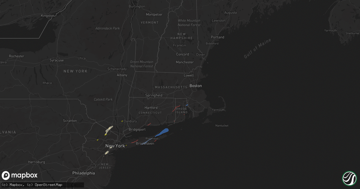
Hail Map in Massachusetts on November 13, 2021
Get this storm
November 13 map
$229
one time, instant access
Download today. No call, no setup
Keep the $229
Bought the map and want the full workflow? Apply the entire $229 to a subscription within 7 days. None of it is wasted.
Every map, not just this one
This buys you this map. Subscription and you get every map we run, in the markets you choose from a few cities to whole states to nationwide. Plus real-time alerts the moment a storm fires.
Contact data
Name, contact info, occupancy, even credit band for addresses in the footprint. You go from where it hit to who to call.
Become the source they trust
Unlimited branding weather history reports on demand. You already have the documented answer ready for the property owner, and you are the one who showed up with it.
Property data and RoofTrace estimates
Pull up any address you have got, its value and the exact code rules for that jurisdiction, straight from One Click Code. Then RoofTrace estimates the squares, pitch, and roof value, priced the way you price.
Storm reports in Massachusetts
Massachusetts
| Date | Description |
|---|---|
| 11/13/20215:40 PM CST | 2 utility poles down... A third utility pole cracked with wires down on old wharf road after beaten road. Road impassable. |
| 11/13/20214:45 PM CST | Tree down blocking adams street between hope st and linden ave |
| 11/13/20214:45 PM CST | Tree adn wires down on thayer street |
| 11/13/20214:44 PM CST | Tree down blocking right hand lane of i-495 near the route 44 exit |
| 11/13/20214:40 PM CST | Tree down blocking potomska road |
| 11/13/20214:25 PM CST | Tree and power lines down on northbridge st |
| 11/13/20214:10 PM CST | Tree down and blocking mine brook road at evergreen road. |
| 11/12/202111:55 PM CST | At 555 PM EST, severe thunderstorms were located along a line extending from Boston to Duxbury to Rochester, moving east at 50 mph. HAZARD...60 mph wind gusts. SOURCE...Radar indicated. IMPACT...Expect damage to trees and power lines. Locations impacted include... Boston, Cambridge, New Bedford, Brockton, Quincy, Lynn, Fall River, Newton, Somerville, Malden, Brookline, Plymouth, Medford, Taunton, Weymouth, Revere, Everett, Braintree, Chelsea and Randolph. |
| 11/12/202111:45 PM CST | At 545 PM EST, a severe thunderstorm was located over Aquinnah, moving northeast at 50 mph. HAZARD...60 mph wind gusts. SOURCE...Radar indicated. IMPACT...Expect damage to trees and power lines. Locations impacted include... Plymouth, Barnstable, Falmouth, Oak Bluffs, Edgartown, Tisbury, Aquinnah, Yarmouth, Sandwich, Bourne, Mashpee, West Tisbury, Chilmark, Gosnold and Hyannis. |
| 11/12/202111:12 PM CST | At 512 PM EST, severe thunderstorms were located along a line extending from near Coventry to near Exeter to near South Kingstown, moving northeast at 50 mph. HAZARD...60 mph wind gusts and penny size hail. SOURCE...Radar indicated. IMPACT...Expect damage to trees and power lines. Locations impacted include... Providence, New Bedford, Fall River, Warwick, Cranston, Pawtucket, Taunton, East Providence, Coventry, Dartmouth, South Kingstown, West Warwick, Johnston, North Kingstown, Newport, Bristol, Attleboro, Easton, Norton and Somerset. |
| 11/12/202110:09 PM CST | At 409 PM EST, a severe thunderstorm was located over Suffield, or near Enfield, moving northeast at 40 mph. HAZARD...60 mph wind gusts and penny size hail. SOURCE...Radar indicated. IMPACT...Expect damage to trees and power lines. Locations impacted include... Springfield, Enfield, Windsor, Agawam, West Springfield, Ludlow, Longmeadow, Suffield, East Longmeadow, Wilbraham, Windsor Locks, Palmer, Stafford, Somers, Granby, East Windsor, Monson, East Granby and Hampden. |
All States Impacted by Hail Map on November 13, 2021
Cities Impacted by Hail Map on November 13, 2021
- Tuxedo Park, NY
- Sloatsburg, NY
- Bayonne, NJ
- Elizabeth, NJ
- Elizabethport, NJ
- Toms River, NJ
- Edison, NJ
- Keasbey, NJ
- Sterling Forest, NY
- Ringwood, NJ
- East Brunswick, NJ
- Perth Amboy, NJ
- Sayreville, NJ
- Fords, NJ
- Woodbridge, NJ
- Staten Island, NY
- Port Reading, NJ
- Sewaren, NJ
- South Amboy, NJ
- Bloomingdale, NJ
- Hewitt, NJ
- West Milford, NJ
- Wanaque, NJ
- Butler, NJ
- Southfields, NY
- Pomona, NY
- Stony Point, NY
- Guilford, CT
- Branford, CT
- Moosup, CT
- Sterling, CT
- Plainfield, CT
- Foster, RI
- North Scituate, RI
- Providence, RI
- Rumford, RI
- Seekonk, MA
- East Providence, RI
- Pawcatuck, CT
- Westerly, RI
- North Kingstown, RI
- Kenvil, NJ
- Ledgewood, NJ
- Succasunna, NJ
- Mine Hill, NJ
- Haskell, NJ
- Mahopac, NY
- Hempstead, NY
- Uniondale, NY
- Huntington Station, NY
- Smithtown, NY
- Melville, NY
- Commack, NY
- Saint James, NY
- Manorville, NY
- Patchogue, NY
- Shirley, NY
- Bellport, NY
- Brookhaven, NY
- Yaphank, NY
- Mastic, NY
- Riverhead, NY
- Sag Harbor, NY
- East Hampton, NY
- Shelter Island, NY
- New Suffolk, NY
- Mattituck, NY
- Southold, NY
- Cutchogue, NY
- Shelter Island Heights, NY
- Hampton Bays, NY


